1001:(OPPD), were confident that enough redundancies were in place to ensure adequate safety. The complex's elevation is 1,004-foot (306 m) elevation above sea level and as of June 19 the river had risen to 1,005.5 feet (306.5 m). Officials from OPPD stated the Calhoun plant could handle water up to 1,014 feet (309 m). An 8 feet (2.4 m) high and 2,000 feet (610 m) long rubber berm surrounded the reactor building. On June 23 a helicopter being used by OPPD to survey transmission lines made an unplanned landing 1.5 miles (2.4 km) south of the plant. The helicopter was photographed lying on its side but there were no reports of injuries. On June 26 the 2,000 feet (610 m) long rubber berm at the plant collapsed after it was punctured by a small earth mover ("Bobcat"). It was reported more than 2 feet (0.61 m) of water rushed in around buildings and electrical transformers. Backup generators were then used to ensure the facility maintained electrical power for cooling. NRC officials were at the plant at the time and NRC statements said the plant remains safe. NRC Chairman
1168:
931:
36:
826:), the main levee suffered a partial collapse. One June 5, it suffered a second partial collapse. On June 7, it suffered a third partial collapse. Finally, on June 13, it suffered a total collapse and had a 300 feet (91 m) wide gap. After the first partial collapse, the Corps of Engineers initiated an emergency contract to raise the levee immediately surrounding the town in order to protect it from an estimated 10 feet (3.0 m) of flood water.
431:
72:
943:
242:
1148:
882:
creating an enormous water pool directly opposite the reactor. Authorities initially reported a 3-to-4-inch (76 to 102 mm) rise in the river after the levee was blown. Both the US Army Corps of
Engineers and the Iowa Department of Natural Resources said they did not regulate the levee. Flooding on the Iowa side had been a source of considerable concern after a June 25 levee breach upstream of the reactor near
734:
201:
1032:) was issued on June 19 due to the flooding. Similar to the situation at Fort Calhoun, the FAA placed a temporary no-fly zone within 2 miles (3.2 km) of the plant on June 7. Officials said, "There is no threat to plant employees or to the public; the plant continues to operate safely." In preparation for the flood more than 5,000 short tons (4,500,000 kg) of sand were bought in for barricades and
91:
723:
192:
80:
213:
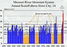
twice the previous record release in 1997. The Corps was criticized for not releasing the water earlier. However the Corps defended its practice noting that it did not foresee a cooler than normal spring which delayed the mountain snowmelt and the record sustained torrential spring rains in
Wyoming and Montana.
507:(Mile 616) – the pedestrian bridge between downtown Omaha and Council Bluffs which had been a popular viewing spot of the flood but was closed temporarily on June 30 while river debris was cleared from its base. The Council Bluffs side was closed on July 2 due to flooding on that side. It reopened September 3.
1135:
On July 13, OPPD said it had spent $ 26 million in June as a result of flooding affecting its power plants on the river ($ 20 million in work protecting its plants and $ 6 million in replacing lost generating capacity). OPPD has two coal-fired plants that are both larger than Fort
Calhoun at Nebraska
1098:
On July 9, the Corps of
Engineers said water behind the reservoirs had peaked on July 2 with only 1.5 percent left for flood storage. By July 9, the available storage increased to 3.1 percent. Officials said they planned to begin decreasing the water flowing to the Gavins Point Dam but noted that the
228:
satellites indicated that precipitation over the MRB undergoes a profound modulation during the transition points of the
Pacific quasi-decadal oscillation and associated teleconnections. The results infer a prominent teleconnection forcing in driving the wet/dry spells in the MRB, and this connection
910:
On July 1, the Corps reported that runoff on the river for June was the largest of any month on the river below Sioux City since record keeping began in 1898. June runoff was 13,800,000 acre-feet (17.0 km), beating the April 1952 record of 13,100,000 acre-feet (16.2 km). The third highest
1036:
protecting facilities at the plant. The plant is 13 feet (4.0 m) above natural grade. On June 19, the river was reported 11.5 feet (3.5 m) above flood stage at
Brownville. The Cooper plant sits at 903 feet (275 m) above sea level. The river hit 900.56 feet (274.49 m) on June 19
212:
to regulate the release of water through 850 miles (1,370 km) of open river from
Garrison Dam in North Dakota to the confluence with the Mississippi River at St. Louis. The Garrison Dam began releasing a record of 152,000 cubic feet (4,300 m) of water per second on June 1, 2011—more than
216:
In attempting to control the flood water release in since all the reservoirs were 100 percent or more of capacity (with the exception of the Fort
Randall Dam), the Corps of Engineers doubled the record release of water in the river's five North and South Dakota dams. Officials said that problems
1423:
The Amelia
Earhart Bridge at Atchison had effectively closed on June 28. Closings of Missouri River bridges had been the result of flooding on the approaches and not the bridge itself. However, on June 29 photos began circulating that the low-lying Atchison Union Pacific rail bridge was close to
921:
As flood waters started to recede by late August, flood damage to
Interstate highways 29 and 680 north of Council Bluffs, Iowa, was reported as extensive. Discounting the interstate system flood damage to county roads in Pottawattamie County alone was expected to amount to $ 40 million in repair
898:
on the DeSoto Bend. They had raised the levee height in anticipation of the flood but after the upstream breach they had sought permission to lower it so that water could flow back into the river. When both Iowa and the Corps said they did not have authority over it the levee board blew it up at
881:
On July 1, the privately owned Vanmann #30 levee at Mile Marker 637 to 637.5 on the Iowa side, about 10 river miles south of the reactor, was blown up by the local levee authority. The levee destruction was done to alleviate flooding in a bend of the river where water was pooling on cropland and
965:
On June 4, Omaha city officials began releasing 6,000,000 US gallons (23,000 m) of raw sewage per day into the river from its plant in South Omaha. The city generates about 86,000,000 US gallons (330,000 m) a day, but only a small percentage is dumped into the river. The city of Omaha
97:
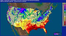
showing number of precipitation inches above/below year to date at June 18, 2011. The map shows that year to date precipitation in the Missouri headwaters basin of Montana had precipitation of 20 inches or more above normal while the rest of the basin precipitation was near normal. Above normal
1303:
in Holt County closed its tour route around its pools noting that it no longer control water levels in its pools and that it expects "critical habitat damage to our management areas including the moist soil units, wet prairie, and other priceless wildlife habitats and most habitats will be
134:
along with near-record spring rainfall in central and eastern Montana. All six major dams along the Missouri River released record amounts of water to prevent overflow which led to flooding threatening several towns and cities along the river from Montana to Missouri; in particular
705:
were evacuated on June 1. On June 20 after they returned, officials announced that a new crest from new heavy rains would result in the river being a foot higher than the first crest. On June 21, 12,000 people, a quarter of the town's population, were ordered to evacuate after
195:
U.S. Army Corps of Engineers Report on June 18, 2011, predicting that 54,600,000 acre-feet (67.3 km) of run off would occur above Sioux City in 2011 -- the most in the history of record keeping on the river. It tops the record flow of 49,000,000 acre-feet (60 km) in
1370:
On July 4 St. Charles held its Riverfront fireworks display on the river—although moved back a block to Riverside Drive from Frontier Park. It had crested there on July 3 at 28.03 feet (8.54 m)—well below its crest of 40.11 in 1884 and 40.04 feet (12.20 m) in 1993.
592:(Mile 396)- Scheduled resurfacing work on the bridge had started in May prior to the flood and traffic had been reduced to one lane. Since it was one of the few bridges open for traffic between Omaha and Kansas City, work on the bridge was halted indefinitely on July 1
183:, in the second half of the month of May 2011, almost a year's worth of rain fell over the upper Missouri River basin. Extremely heavy rainfall in conjunction with an estimated 212 percent of normal snowpack in the Rocky Mountains contributed to this flooding event.
1419:
was closed temporarily to pump water which had accumulated from rains. Elwood is also underwent voluntary evacuations. 200 National Guard troops were deployed to Doniphan County to assist in the evacuation. 400 of Elwood's 1,200 residents voluntarily evacuated.
1179:
via the Missouri River Bank Stabilization and Navigation Project and Missouri River Fish and Wildlife Mitigation Project that they were seeking willing sellers for land "for fish and wildlife habitat enhancements for aquatic species such as the
1236:, at Mile Marker 550. The crest at Brownville at 44.6 feet (13.6 m) was the highest in the history of the river there (breaking the 1993 record). It prompted officials to close the two northernmost Missouri River bridges in the state, the
988:
placed flight restrictions over the plant within a 2 miles (3.2 km) radius in which planes cannot fly lower than 3,500 feet (1,100 m) over the plant. On June 7, a fire broke out in the plant's switch gear room, prompting the
1459:
In 2023, the U.S. Court of Appeals for the Federal Circuit upheld a lower court’s 2020 ruling that the U.S. Army Corps of Engineers was responsible for worsened flooding since 2007 that killed crops and wrecked homes and businesses.
1065:
On July 1, the flood level at Omaha hit 36.29 feet (11.06 m), higher than the 30.26 feet (9.22 m) on July 10, 1993, during the 1993 flood but lower than the all-time record of 40.2 feet (12.3 m) on April 18, 1952.
911:
record was 10,500,000 acre-feet (13.0 km) which was set in May 2011. The combined runoff for May and June was 24,300,000 acre-feet (30.0 km). The normal for the entire year is 24,800,000 acre-feet (30.6 km).
1037:
before dropping slightly to 900.4 feet (274.4 m) on June 20. At 9:47 a.m., July 12 the plant ended its emergency status because the river had dropped to 895.8 feet—3 feet lower than the emergency status level.
1224:
after the railroad elevated its line near the community by 20 inches (510 mm) in preparation for the flood. Big Lake officials said the elevation would create a "bathtub" effect, trapping water in the community.
1184:." The letters arrived just as the floods began hitting their peak in Atchison County and subsequently were heavily criticized by state and federal politicians. The Corps reported that only 14 letters had been sent.
1130:
the river depth of the channel at Nebraska City is normally 12 to 16 feet (3.7 to 4.9 m) and, during high water, can be 25 to 30 feet (7.6 to 9.1 m) but during this event they recorded depths of 66 feet
442:
from just above Gavins Point to northern Missouri. The closings made it impossible to cross the river for more than 100 miles (160 km) between Sioux City and Omaha and another 100 miles (160 km) between
2647:
545:. The bridge was open between Atchison and the small unincorporated community of Winthrop, Missouri, immediately across the bridge; however, access to Kansas City or St. Joseph on the Missouri side via
3846:"Flooding on Missouri River slows down Bagnell Dam Plant procedures – Camdenton, MO – Serving Missouri's Lake of the Ozarks region including Osage Beach, Camdenton, Lake Ozark, Eldon and Sunrise Beach"
1009:
north of the plant effectively making the river impossible to drive across for 100 miles (160 km) from Sioux City to Omaha—although officials said they hoped to erect flood barriers to reopen it.
4142:
3100:
1526:
774:, after they drove their car down a washed out road. The fatalities were unrelated to flooding and increased releases on the Missouri River, but rather related to flash flooding from heavy rains
878:(16 miles north of Hamburg) breached in the early morning hours adding to the flooded conditions from the Hamburg breach. The breach occurred despite a month-long battle by the local residents.
4067:
3845:
2316:
3175:
2367:
3250:
1139:
In Omaha, after peaking at 36.29 feet (11.06 m) on July 2, 2011, the river was still more than 3 feet (0.91 m) above the flood stage of 29 feet (8.8 m) as of August 28.
1252:). The river had risen more than two feet in 24 hours in Atchison County. Officials said the surge in the river occurred when heavy rains in northern Iowa caused a major rise in the
4194:
962:, closed because of flood fears. Exhibits were moved and berms were built around the buildings. On July 13, officials said the flooding was not as severe as had been expected.
1175:
On June 6, the Kansas City Corps of Engineers sent letters from its Real Estate Division to landowners along the river in northwest Missouri, telling them that through the
2012:
970:
to evacuate storm and sewer water directly into the Missouri River. By June 22, the city estimated 3 million dollars had been spent directly towards this flooding event.
2416:
3997:
3975:
3298:
1363:
On July 3 a planned fireworks display in Richard Berkley Riverfront Park in Kansas City proceeded as planned and included the unveiling of a new lighting scheme on the
3472:
1777:
2725:
1490:
2038:
4296:
3702:
1882:
3446:
2669:
2617:
1136:
City. One of the rail lines providing coal was covered in water and the utility wanted to raise that track. The plants had been getting coal via a parallel line.
934:
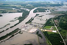
County Road 34 in Fort Calhoun, Nebraska, underwater on June 19. The closer treeline in the distance is the normal west bank of the Missouri River and is part of
4328:
4270:
1337:
reported that residents of Holt County had dubbed the flood "Corpstrina" (pronounced Kor-TRINA) evoking the Corps of Engineers which regulates the river and the
1073:
with a seepage berm to allow water to seep through the levee but hold the levee materials in place. The action came after the Corps reported there were multiple
2777:
2695:
737:
86:
of flooding areas on June 18, 2011. The Missouri River is reflected by gages in the middle and top. Purple reflects heavy flooding and orange moderate flooding.
3728:
2089:
984:, where the grounds of the plant were inundated by the flood, however, the plant had been in safe shutdown mode for refueling since April 2011. On June 6, the
204:
The flood in the last two weeks of June was made more intense by rains 600 percent or more above normal in the Missouri River basin below the Gavins Point Dam.
2487:
1530:
4146:
1367:(Mile 365). The crest at Kansas City of 32.46 feet (9.89 m) on July 2 was well below Kansas City's all time crest of 48.87 feet (14.90 m) in 1993.
973:
On June 9, Nebraska reported its first event-related fatality when a worker was killed while working on a levee at Fort Calhoun when his truck tipped over.
562:(Mile 648) -- The bridge closed for June 27-July 1 while flood barriers were erected in Iowa. It was also closed again July 6–7 for further shoring up work.
4019:
3949:
811:
known locally as "the Duck" was used to provide transportation from Sloan across the floodwaters to the casino. The Duck now makes annual appearances as a
252:
In May 2011, dams above Gavins Point began stepping up the release of water (in cubic feet/second), exceeding all previous nationwide records for release.
3104:
2320:
2291:"Gov. Calls For 'Country Club' Evacuation – KELOLAND.com | Sioux Falls News & Weather, South Dakota News & Weather, Minnesota and Iowa News"
2371:
4418:
918:
said they were experiencing higher ticket sales. They speculated that the difficulty of driving from Sioux City and Omaha had spurred the increase.
3849:
1555:
3398:
3183:
1475:
1364:
1176:
1127:
the river normally flows at 4 miles (6.4 km) per hour but in the early days of the flood it was flowing at 11.6 miles (18.7 km) per hour
1084:
977:
589:
439:
458:
During the flood, every bridge between Omaha and Kansas City was either closed entirely, had exit ramps blocked or had other work at some point.
4071:
3254:
1698:
2833:
2393:
1955:
1271:
474:. The bridge actually remained open but flooding on the Nebraska side made it a dead end. However some people (particularly employees at the
209:
2214:
230:
3569:
2594:
2241:
1824:
1669:
1577:
1300:
1216:(which had evacuated during several floods including one in 2010) evacuated in May. On June 16, 2011, the community filed an injunction in
935:
2139:
1289:
903:, officials initially said they were notified only minutes prior to the levee being blown up, but those overseeing the levee had notified
1605:"The Pacific quasi-decadal oscillation (QDO): An important precursor toward anticipating major flood events in the Missouri River Basin?"
478:) used motor boats, kayaks, chest waders and a homemade “swamp bike” to commute between the bridge and their cars outside the flood area.
4221:
3922:
3895:
3650:
1029:
994:
467:
3077:
498:
4428:
4045:
2268:
1025:
208:
The flood, rather than being a short term event, was anticipated to last from June through August 2011 as a result of attempts by the
4198:
2016:
1054:
On June 29, Nebraska reported its first flood-related death when the body of a 26-year-old fisherman was found in the river near the
1293:
481:
3872:
3781:
3623:
3591:
1982:
3754:
2290:
1436:
661:
4388:
3520:
2177:
3498:
2999:
1799:
1724:
1080:
On July 3, Lindbergh Road which rings Eppley by the levees was closed so work could continue on 70 relief wells by the levees.
1051:
in Omaha were functional. The wells pump water collecting around the airport over the levee wall back into the Missouri River.
985:
895:
861:
224:
A study by Utah State University examined the buildup of water storage leading to the 2011 Missouri River flooding observed by
4361:
3420:
3368:
3276:
3148:
2859:
2807:
2751:
2546:
2420:
2063:
1908:
1850:
4423:
3476:
1357:
1017:
4115:
3078:"Nebraska residents in no danger after floods hit nuke plant: Waters breach berm at Fort Calhoun nuclear station – ABC News"
2729:
1069:
On July 2, the Corps of Engineers awarded a $ 1.4 million contract to shore up the 9 miles (14 km) levee system around
4393:
3808:
3676:
2915:
2118:
1934:
1497:
2572:
1886:
1440:
1167:
990:
217:
downstream could have been alleviated by river control work and new levee construction that came about in the wake of the
4303:
3706:
3450:
2673:
2625:
45:
4168:
3342:
1006:
887:
698:
607:
559:
504:
103:
3228:
2417:"WinnaVegas closed its doors after county closed the road – KTIV NewsChannel 4 Sioux City IA: News, Weather and Sports"
930:
4335:
4274:
4023:
1205:
The United States Coast Guard closed the river to boaters from Gavins Point Dam (Mile Post 850) to Mile Post 450 near
998:
800:
2785:
2703:
1344:
On July 2 Amtrak announced that two miles (3 km) of track between Kansas City and St. Louis was flooded between
4143:"Leavenworth Closes Brush Site, Airfield and Finishes Sandbagging | Environment | Leavenworth County News"
4093:
3732:
2093:
179:. Many smaller towns were also at risk, suffering the same fate as the larger cities if not worse. According to the
3833:
2495:
2465:
900:
771:
760:
148:
144:
1647:
867:
On June 27, officials said water "could begin slopping" over the emergency levee at Hamburg on its west side. The
1229:
749:
75:
Corps of Engineers photo of June 16, 2011, showing the Fort Calhoun nuclear power plant surrounded by flood water
3953:
3277:"Missing Boater's Remains Found in Flooded Missouri – Action 3 News – Omaha, Nebraska News, Weather, and Sports"
3176:"Cooper Nuclear Station declares "Notification of Unusual Event" – Nebraska City, NE – Nebraska City News-Press"
682:
declared much of North Dakota a disaster area over flooding which began on February 14 and had been continuing.
3873:"KCP&L has boats ready as floodwaters rise near power plant – KCTV5 – Kansas City News, Weather and Sports"
3179:
1432:
1382:
475:
180:
172:
2946:
1087:
reported that 265 square miles (690 km) of Nebraska has been inundated by floods on the Missouri and the
1005:
confirmed the plant's safety when he visited the plant on June 27. On June 29 officials planned to close the
2891:
1375:
1195:
686:
673:
514:
2886:
2443:
1424:
water level. Union Pacific had embargoed its main rail line which goes between St. Joseph and Kansas City.
1013:
981:
959:
164:
136:
2517:
434:
Interchange of I-29 and I-680 north of Council Bluffs, Iowa, looking towards the Mormon Bridge on June 16
3546:
2977:
2202:
1405:
1378:
1334:
1217:
915:
904:
883:
857:
845:
740:
comparing the river between Sioux City and Leavenworth on June 30, 2011 (top) and June 29, 2010 (bottom)
538:
490:
444:
168:
1155:, as the River reached a width of more than 5 miles on June 26. The line going across the water is the
3394:
1619:
1206:
1041:
1021:
841:
781:
745:
617:
613:
524:
510:
448:
342:
221:. However, they were unsure whether the levees could sustain being waterlogged in a long-term flood.
160:
140:
4248:
1702:
1408:. On June 29 the levee was breached and water reached the hangars which had earlier been evacuated.
1374:
On July 6 a breach at Atchison County that had started on June 19 widened to 600 feet (180 m).
1116:
the flood water which is predominately coming from behind dams is clear rather than the traditional
248:
release gates discharging floodwater at 150,000 cu ft/s (4,200 m/s) on June 15, 2011.
1416:
1349:
1275:
1199:
1152:
816:
702:
653:
649:
579:
218:
176:
3976:"Advanced Hydrologic Prediction Service: Kansas City/Pleasant Hill: Missouri River at Kansas City"
1959:
1435:, on both sides of the river were either overtopped or breached. Included in the overtoppings was
1296:. Residents of the Sugar Lake area of Buchanan County were also under voluntary evacuation orders
1386:
1353:
1213:
1104:
1055:
967:
951:
830:
808:
573:
471:
452:
225:
2245:
1828:
1673:
1581:
1326:, sent 40 of its 135 employees home because of fears that the river would cut off its access on
796:
3627:
4362:"US engineers contributed to Missouri River flood damage and must pay landowners, court rules"
1393:
1338:
1327:
1253:
1237:
1233:
868:
694:
657:
641:
629:
520:
485:
4225:
3926:
3899:
3654:
1648:"Teleconnection and the buildup of water storage leading to the 2011 Missouri River flooding"
4046:"Residents of already flooded NW Mo. town evacuate – again – due to Missouri River flooding"
3524:
3320:
1752:
1627:
1448:
1345:
1257:
1059:
764:
726:
707:
693:
which comes close to the Missouri but is not a tributary as it flows instead north into the
633:
569:
542:
402:
380:
152:
430:
71:
3424:
3372:
2811:
2755:
2550:
2368:"Pierre officials estimate flood costs at $ 13.2 million – so far | The Argus Leader"
2067:
1912:
1854:
1444:
1428:
1323:
1282:
1264:
1181:
1160:
1070:
1048:
942:
853:
756:
625:
565:
546:
494:
241:
156:
123:
17:
3026:
2317:"Recent rain raises reservoirs, contributes to tributary trouble | The Argus Leader"
3785:
3598:
1986:
1623:
1360:
but continued to maintain other traffic via trains rerouted to the Sedalia subdivision.
1151:
Looking toward Rulo and Big Lake (the latter of which is obliterated in the trees) from
229:
implies persistence of dry conditions for the next 2 to 3 years, which is linked to the
106:
earlier in the year. Significantly lower than normal rain in eastern Arizona led to the
52:
Please help update this article to reflect recent events or newly available information.
4169:"Levee Breached Near Sherman Army Airfield – Kansas City News Story – KMBC Kansas City"
4119:
3758:
3677:"Flooding Grows In Holt, Atchison Counties – Kansas City News Story – KMBC Kansas City"
2394:"Corps of Engineers to inspect Big Bend Dam spillway on Missouri River in South Dakota"
2294:
1412:
1249:
1241:
1191:
1163:, powerplant. BNSF raised the line 20 inches but it was still overtopped and is closed.
1121:
1002:
875:
784:, officials estimated costs from the flood would be $ 13.2 million for that community.
770:
On June 21, South Dakota reported its first flood fatalities when two women drowned in
711:
583:
533:
115:
3205:
3126:
1147:
733:
200:
4412:
2181:
1604:
1187:
1099:
water going into Gavins Point would fill it in 1.5 days if the reservoir were empty.
1033:
891:
849:
834:
823:
645:
637:
621:
568:(Mile 602) – The bridge was closed June 27-July 2 due to flooding and sandbagging of
290:
119:
3003:
2342:
1983:"Evacuations begin in southern Buchanan County – St. Joseph News Story – St. Joseph"
1427:
On July 1 the Corps of Engineers reported that every non-federal levee from Rulo to
775:
3152:
3052:"Flood berm collapses at Nebraska nuclear plant – US news – Environment – NBC News"
2863:
1112:
researchers who are studying unique aspects of the flood. Among their discoveries:
1088:
955:
812:
690:
679:
358:
312:
3998:"Advanced Hydrologic Prediction Service: St. Louis: Missouri River at St. Charles"
1285:(via Rulo) after the river widened in Holt County to nearly 5+ miles by Big Lake.
1447:. Another report indicated that the only overtopped federal levee was the one at
1381:
were used to bring in 2,000 pound sand bags to reinforce the Sugar Tree levee in
787:
On June 30, the spillway at Big Bend Dam was temporarily closed for inspections.
3812:
3680:
2923:
1316:
1312:
1281:
On June 26 BNSF had to close its main rail line providing coal to Kansas City's
1245:
804:
529:
107:
3299:"Advanced Hydrologic Prediction Service: Omaha/Valley: Missouri River at Omaha"
2013:"More Missouri River crossings closing | Des Moines Register Staff Blogs"
767:) to evacuate. He noted that it might be two months before they could return.
99:
79:
4172:
3923:"Holt County continues to deal with flooding – Local News Story – St. Joseph"
3346:
3343:"Omaha's Spent $ 3.9 Million On Flood Fight - Omaha News Story - KETV Omaha"
1092:
1074:
90:
1527:"Record precipitation, reservoir releases to cause Missouri River flooding"
1159:
rail line which is the main line for providing coal to Kansas City's giant
722:
83:
3051:
2151:
4402:
1632:
586:, was closed temporarily on June 28 while storm water could be pumped off
334:
245:
2006:
2004:
1578:"South Dakota eyes stepped up Missouri River dam releases – Yahoo! News"
1091:. At the same time NASA released satellite photos of the flood from the
191:
131:
127:
3101:"The Associated Press: Flood berm collapses at Nebraska nuclear plant"
1778:"Corps alters flow from dam to protect Pierre | The Argus Leader"
1476:
Missouri River Near Williston, North Dakota - National Weather Service
1322:
On June 29, officials at Missouri's largest coal-fired power plant at
946:
Cooper Nuclear Power Station on the edge of the flood on June 15, 2011
4398:
1308:
729:
releasing record 150,000 cubic feet/second of water on June 14, 2011.
710:
had to step up its release of water. Amtrak suspended service on the
3896:"Iatan plant sends some people home – Local News Story – St. Joseph"
3703:"Overtopped levees prompt evacuations in Atchison and Holt counties"
2203:
James River near Grace City, North Dakota - National Weather Service
451:, at Mile Marker 450. Authorities were also considering closing the
94:
1330:. Employees were parking a mile from the plant being shuttled in.
1166:
1146:
941:
929:
732:
721:
429:
240:
199:
190:
89:
78:
70:
2242:"Flooding forces evacuations in two Midwest states – Yahoo! News"
1232:
was breached and the levee protecting Big Lake was breached near
1044:
bridge breached, prompting an evacuation in Atchison County, MO.
4394:
Spring 2011 Flood Information (Corps of Engineers - Kansas City)
4222:"Officials fight flooding river – Local News Story – St. Joseph"
3651:"Railway buildup causes concern – Local News Story – St. Joseph"
1825:"Missouri River flood closes 100 miles of bridges – Yahoo! News"
1292:
riverboat casino closed. Levee toppings prompted the closure of
1221:
1171:
Breaching of the levee at Mile 550 in Atchison County on June 19
1156:
1117:
1109:
1047:
On June 27, officials said 12 of 70 planned dewatering wells at
871:
on its east side was reported to be two feet above flood stage.
2518:"Levee breach in Iowa along Missouri River prompts evacuations"
3395:"NASA – Landsat 5 Captures Missouri River Flooding Near Omaha"
29:
4094:"In brief | Missouri River traffic closes; levee bursts"
4068:"Carroll County Residents Band Together to Save Levee – WDAF"
3782:"Flooding closes casino – St. Joseph News Story – St. Joseph"
938:, while the further treeline is the normal east bank of Iowa.
886:, prompted evacuations of 18 homes, temporary closing of the
3570:"McCaskill chides Corps for timing of letters to landowners"
2178:"FEMA: President Declares A Major Disaster For North Dakota"
1311:
to halt all outflows (including electrical generation) from
576:, had water up to the top of its basketball hoops on July 2.
549:
was closed. Residents of Winthrop were evacuated on June 27.
4389:
Spring 2011 Flood Information (Corps of Engineers - Omaha)
3950:"Flooding forces Amtrak to cut service – Independence, MO"
3321:"FEMA: National Situation Update: Thursday, June 30, 2011"
1556:"Nature, not the Corps of Engineers, is driving the flood"
1256:, which enters the Missouri River in Atchison County near
1040:
On June 23, the main levee 3 miles (4.8 km) north of
2595:"Explosives Used to Breach Levee, Investigation Underway"
4116:"UPDATE 5: Coast Guard closes portion of Missouri River"
572:. Flooding in Haworth Park at the base of the bridge in
2887:"Nebraska Nuclear Plant Lost Cooling System After Fire"
1356:. The railroad suspended the 311 and 316 trains of the
1095:
showing flooding from Blair to Plattsmouth to June 30.
829:
On June 22, a mandatory evacuation of all residents in
3809:"Flooding Evacuations Move South Along Missouri River"
3229:"Cooper Nuclear Station no longer at emergency status"
1389:
after a third of the landside part of the levee slid.
3729:"Flooding forces Lewis and Clark State Park to close"
2834:"Low-level emergency declared at nuclear power plant"
2119:"Flooding hits Huntley; Interstate 90 remains closed"
1520:
1518:
776:
according to the Lyman County Herald of Presho, S.D.
714:
through Minnesota, North Dakota and eastern Montana.
3027:"Nuclear Plant's Vital Equipment Dry, Officials Say"
2466:"Scramble to save Iowa town as floodwaters approach"
2269:"S. Dakota residents evacuate ahead of dam releases"
656:. Flooding on Pryor Creek, another tributary of the
2978:"River falls short of Nebraska nuke plant shutdown"
2916:"Nuke Plant Lost Spent Fuel Pump In Suspected Fire"
2113:
2111:
4271:"Businesses get ready for Missouri River flooding"
2696:"Missouri River Flooding To Leave Lasting Effects"
1693:
1691:
1550:
1548:
1392:On July 11 the Coast Guard closed the river above
2971:
2969:
2967:
48:may be compromised due to out-of-date information
3253:. ncnewspress.com. June 24, 2011. Archived from
2444:"Missouri River levee near Hamburg, Iowa, fails"
2370:. argusleader.com. June 22, 2011. Archived from
2319:. argusleader.com. June 22, 2011. Archived from
4249:"Atchison, Kan. | Flickr - Photo Sharing!"
3731:. KansasCity.com. June 24, 2011. Archived from
2343:"Flash Flood Claims two lives near Lower Brule"
1772:
1770:
993:to declare an "Alert", which is level 2 on the
759:urged residents in the Country Club section of
628:and the Wyoming state line. May 26 flooding on
4145:. Leavenworthcounty.fox4kc.com. Archived from
3206:"Swollen Missouri River spurs new evacuations"
493:(Mile 622) between Nebraska and Iowa north of
4195:"State Responds To Northeast Kansas Flooding"
3592:"Corps' response to "Willing Seller" letters"
3127:"Flood berm bursts at Nebraska nuclear plant"
3000:"No One Hurt In Emergency Helicopter Landing"
2015:. Blogs.desmoinesregister.com. Archived from
1805:. U.S. Army Corps of Engineers. June 28, 2011
890:(while flood walls were built to protect the
864:was also impacted by the break in the levee.
738:Moderate Resolution Imaging Spectroradiometer
447:(just south of Omaha) at Mile Marker 591 and
8:
2778:"Mayor's Office: $ 3 Million Spent On Flood"
2541:
2539:
2293:. Keloland.Com. June 3, 2011. Archived from
2152:"Montana flooding swamps towns, reservation"
1800:"Missouri River Mainstem Reservoir Bulletin"
1747:
1745:
1725:"Missouri River Mainstem Reservoir Bulletin"
807:, was inaccessible. Shortly after, a yellow
532:(Mile 497) between Nebraska and Missouri at
523:(Mile 535) between Nebraska and Missouri at
4020:"Rising waters force Riverfest to relocate"
2215:"Minot preparing for new Souris River high"
1730:. US Army Corps of Engineers. June 22, 2011
513:(Mile 561) between Nebraska and Iowa (near
27:2011 flood affecting multiple states in USA
2810:. Omaha.com. June 10, 2011. Archived from
1491:"Missouri River Mainstem Reservoir System"
644:created flooding that closed a portion of
541:(Mile 422) between Kansas and Missouri at
484:(Mile 691) between Nebraska and Iowa near
254:
4171:. Kmbc.com. June 24, 2007. Archived from
3002:. Wowt.com. June 23, 2011. Archived from
2754:. Omaha.com. June 4, 2011. Archived from
2236:
2234:
2232:
2058:
2056:
1911:. Omaha.com. July 2, 2011. Archived from
1876:
1874:
1872:
1631:
1267:in Holt County were ordered to evacuate.
966:installed giant water pumps just east of
3345:. Ketv.com. June 7, 2011. Archived from
2140:Flooding closes stretch of Interstate 90
1956:"City of Atchison, Kansas / Rumor Watch"
1935:"Iowa Side Of Pedestrian Bridge Reopens"
697:in Canada, which also experienced prior
438:The flood forced the closing of several
4297:"Non-Federal Levee Status Daily Report"
4118:. D8externalaffairs.com. Archived from
3547:"Pdf : Corps letter to landowners"
2217:. Bismarcktribune.com. November 3, 2010
1701:. Nwd-mr.usace.army.mil. Archived from
1670:"Riverwatch 2011 Missouri River Region"
1558:. Bismarcktribune.com. November 3, 2010
1468:
1177:Water Resources Development Act of 1986
1085:National Geospatial-Intelligence Agency
997:. Officials for the plant's owner, the
978:Fort Calhoun Nuclear Generating Station
590:Centennial Bridge (Leavenworth, Kansas)
470:between Nebraska and South Dakota near
1529:. Columbia Missourian. Archived from
837:and the Missouri River was declared.
822:On June 4, near River Mile 575 (near
7:
3848:. Lakenewsonline.com. Archived from
3369:"The latest on the flooding: July 5"
1958:. Cityofatchison.com. Archived from
1485:
1483:
1301:Squaw Creek National Wildlife Refuge
936:Boyer Chute National Wildlife Refuge
840:On June 25, a levee breach north of
122:was triggered by record snowfall in
4399:MightyMoRiver crowd-sourced project
4329:"Federal Levee Status Daily Report"
3755:"Customers – Weather Interruptions"
2726:"Cody ranch plans August reopening"
2121:. Billingsgazette.com. May 22, 2011
2039:"Iowa Department of Transportation"
468:Chief Standing Bear Memorial Bridge
4360:Beck, Margery A. (June 22, 2023).
4224:. Newspressnow.com. Archived from
3925:. Newspressnow.com. Archived from
3898:. Newspressnow.com. Archived from
3784:. Newspressnow.com. Archived from
3653:. Newspressnow.com. Archived from
3521:"Corps letter adds to flood anger"
3401:from the original on July 10, 2011
2011:Lucas Grundmeier (June 27, 2011).
1985:. Newspressnow.com. Archived from
1699:"Reservoir Control Center Reports"
1077:on the airport side of the levee.
744:On June 1, nearly 3,000 people in
25:
4141:Scott Macintosh (June 22, 2011).
3811:. OzarksFirst.com. Archived from
2922:. Omaha, Nebraska. Archived from
2840:. Lincoln, Nebraska. June 6, 2011
2702:. August 25, 2011. Archived from
2670:"The latest on flooding: July 11"
2573:"Breach brings flood to Percival"
2547:"The latest on flooding: June 28"
2488:"Mills County Residents Evacuate"
2090:"Flood halts bridge construction"
1851:"Flood forces creative commuting"
1294:Lewis and Clark Village, Missouri
1290:Terrible's St. Jo Frontier Casino
958:'s home near the Platte River in
899:approximately 10 a.m. on July 1.
755:On June 3, South Dakota governor
616:and nearby tributaries inundated
612:On May 22, 2011, flooding of the
597:Flood stages and effects by state
582:(Mile 448) – South bound exit in
554:Short term closings/interruptions
482:Burt County Missouri River Bridge
4419:2011 floods in the United States
4273:. KansasCity.com. Archived from
3921:Marshall White (June 30, 2011).
3705:. KansasCity.com. Archived from
2752:"City dumps raw sewage in river"
2618:"Citizens blow up private levee"
2244:. News.yahoo.com. Archived from
2092:. KansasCity.com. Archived from
2064:"The latest on flooding: July 3"
1909:"The latest on flooding: July 2"
1883:"The latest on flooding: July 1"
1827:. News.yahoo.com. Archived from
1780:. argusleader.com. June 21, 2011
1580:. News.yahoo.com. Archived from
1437:Kansas Department of Corrections
1415:, south bound exit ramp off the
1194:(across the Missouri River from
1028:" (the least-serious of the NRC
662:Pompeys Pillar National Monument
34:
3948:Evenson, Kelly (July 2, 2011).
3473:"OPPD flood bill so far: $ 26M"
3421:"Reservoirs gain a little room"
3076:Kerley, David (June 27, 2011).
3025:Wald, Matthew (June 27, 2011).
2945:Smollen, Gary (June 14, 2011).
2784:. June 23, 2001. Archived from
2616:Nelson, Andrew (July 2, 2011).
2442:Avok, Michael (June 13, 2011).
2415:Gannon, Katie (June 10, 2011).
1404:On June 22, Leavenworth closed
986:Federal Aviation Administration
896:DeSoto National Wildlife Refuge
874:On July 1, the main levee near
862:DeSoto National Wildlife Refuge
114:The 2011 flooding event on the
4247:City, Kansas (June 27, 2011).
3952:. The Examiner. Archived from
3251:"Levee Breach Near Brownville"
2494:. 24 June 2011. Archived from
1307:On June 28, the Corps ordered
1018:Nebraska Public Power District
995:NRC's emergency classification
799:Casino, which is owned by the
440:Missouri River traffic bridges
426:Missouri River bridge closings
1:
3151:. Tfr.faa.gov. Archived from
2862:. Tfr.faa.gov. Archived from
2396:. The Republic. June 30, 2011
1441:Lansing Correctional Facility
1396:, at Mile 226 to navigation.
1263:On June 21, 300 residents of
1026:Notification of Unusual Event
1020:'s (NPPD) nuclear plant near
991:Nuclear Regulatory Commission
4070:. Fox4kc.com. Archived from
2947:"Ft. Calhoun Flood Defenses"
2914:Cole, Kevin (June 8, 2011).
2885:Tracy, Ryan (June 8, 2011).
2267:CHET BROKAW (June 4, 2011).
1612:Geophysical Research Letters
1120:that gives the Missouri its
608:2011 Musselshell River flood
560:Blair Bridge (U.S. Route 30)
505:Bob Kerrey Pedestrian Bridge
231:2012–2013 Midwestern drought
104:2011 Mississippi River flood
3626:. Omaha.com. Archived from
3523:. Omaha.com. Archived from
3475:. Omaha.com. Archived from
3449:. Omaha.com. Archived from
3447:"USGS notes flood's quirks"
3423:. Omaha.com. Archived from
3397:. Nasa.gov. June 30, 2011.
3371:. Omaha.com. Archived from
2728:. Omaha.com. Archived from
2672:. Omaha.com. Archived from
2549:. Omaha.com. Archived from
2066:. Omaha.com. Archived from
1885:. Omaha.com. Archived from
1853:. Omaha.com. Archived from
999:Omaha Public Power District
801:Winnebago Tribe of Nebraska
4445:
4197:. Wibw.com. Archived from
4022:. ksdk.com. Archived from
3679:. Kmbc.com. Archived from
3227:the Lincoln Journal Star.
2648:"Niet compatibele browser"
2419:. Ktiv.com. Archived from
2180:. Fema.gov. Archived from
1753:"Niet compatibele browser"
1451:by Sherman Army Airfield.
1272:Lewis and Clark State Park
1190:closed in early June from
976:The flooding affected the
901:Pottawattamie County, Iowa
772:Lyman County, South Dakota
685:Some of the most dramatic
671:
605:
149:South Sioux City, Nebraska
145:Dakota Dunes, South Dakota
18:2011 Missouri River floods
4429:2011 in the United States
3499:"Missouri River at Omaha"
1030:emergency classifications
914:On July 11, officials at
3624:"The latest on flooding"
3208:. CNN.com. June 15, 2011
3180:Nebraska City News-Press
3129:. CNN.com. June 27, 2011
2808:"The latest on flooding"
1433:Wyandotte County, Kansas
1383:Carroll County, Missouri
476:Mike Durfee State Prison
181:National Weather Service
173:Jefferson City, Missouri
98:precipitation along the
95:U.S. Weather Service map
3894:St. Joseph News-Press.
2892:The Wall Street Journal
1376:Missouri National Guard
1365:Christopher Bond Bridge
1319:until at least July 5.
1196:Nebraska City, Nebraska
817:Winnebago High School's
689:in North Dakota was on
674:2011 Souris River flood
515:Nebraska City, Nebraska
237:Release of water by dam
3757:. BNSF. Archived from
3149:"1/6704 NOTAM Details"
2860:"1/6523 NOTAM Details"
1603:Wang, Shih-Yu (2014).
1228:On June 19 a levee in
1172:
1164:
1014:Cooper Nuclear Station
982:Fort Calhoun, Nebraska
947:
939:
741:
730:
632:inundated portions of
435:
249:
205:
197:
165:Saint Joseph, Missouri
137:Bismarck, North Dakota
111:
87:
76:
4424:Missouri River floods
4341:on September 28, 2011
4309:on September 20, 2011
3630:on September 19, 2012
3604:on September 28, 2011
2423:on September 28, 2011
1406:Sherman Army Airfield
1379:Blackhawk helicopters
1358:Missouri River Runner
1335:St. Joseph News-Press
1170:
1150:
945:
933:
916:Sioux Gateway Airport
907:, officials earlier.
905:Harrison County, Iowa
884:Missouri Valley, Iowa
858:Missouri Valley, Iowa
736:
725:
539:Amelia Earhart Bridge
445:Plattsmouth, Nebraska
433:
244:
203:
194:
169:Kansas City, Missouri
93:
82:
74:
3527:on September 6, 2012
3427:on September 7, 2012
3375:on September 5, 2012
2814:on September 6, 2012
2758:on September 5, 2012
2468:. CNN. June 14, 2011
1915:on September 6, 2012
1857:on September 6, 2012
1633:10.1002/2013GL059042
1207:St. Joseph, Missouri
782:Pierre, South Dakota
678:On May 10 President
660:prompted closing of
614:Little Bighorn River
525:Brownville, Nebraska
511:Nebraska City Bridge
449:St. Joseph, Missouri
269:Previous record year
264:Previous record flow
161:Council Bluffs, Iowa
141:Pierre, South Dakota
4122:on January 21, 2013
4026:on January 27, 2013
4000:. Water.weather.gov
3978:. Water.weather.gov
3301:. Water.weather.gov
2553:on January 30, 2013
2347:Lyman County Herald
2070:on January 30, 2013
1624:2014GeoRL..41..991W
1417:Pony Express Bridge
1385:, near Mile 300 at
1200:Rock Port, Missouri
1153:Fortescue, Missouri
1056:Little Nemaha River
848:which could impact
844:flooded an area of
819:homecoming parade.
701:. 10,000 people in
580:Pony Express Bridge
284:Flow June/July 2011
219:Great Flood of 1993
177:St. Louis, Missouri
3815:on October 3, 2011
3453:on August 13, 2012
3257:on August 11, 2011
3031:The New York Times
2732:on August 13, 2012
2622:Omaha World Herald
2184:on August 27, 2011
2041:. News.iowadot.gov
1881:The World-Herald.
1173:
1165:
1105:Omaha World-Herald
968:Qwest Center Omaha
948:
940:
809:amphibious vehicle
742:
731:
636:. Waters from the
574:Bellevue, Nebraska
472:Niobrara, Nebraska
462:Long term closings
453:Plattsmouth Bridge
436:
397:157,000 (planned)
375:165,000 (planned)
250:
210:Corps of Engineers
206:
198:
112:
88:
77:
4201:on March 25, 2012
4175:on March 22, 2012
3956:on March 20, 2012
3902:on March 14, 2012
3852:on March 21, 2012
3761:on April 12, 2011
3683:on March 22, 2012
3568:Messenger, Tony.
3349:on March 20, 2012
3231:. Journalstar.com
2926:on March 20, 2012
2895:. Omaha, Nebraska
2788:on March 20, 2012
2706:on March 20, 2012
2297:on March 22, 2012
1525:Schick, Anthony.
1394:Glasgow, Missouri
1339:Hurricane Katrina
1328:Missouri Route 45
1254:Nishnabotna River
1238:Brownville Bridge
1234:Corning, Missouri
952:Scouts Rest Ranch
894:) and closing of
869:Nishnabotna River
695:Assiniboine River
658:Yellowstone River
642:Yellowstone River
630:Musselshell River
521:Brownville Bridge
486:Decatur, Nebraska
423:
422:
307:65,500 (June 19)
279:Flow May 31, 2011
67:
66:
16:(Redirected from
4436:
4377:
4376:
4374:
4372:
4357:
4351:
4350:
4348:
4346:
4340:
4334:. Archived from
4333:
4325:
4319:
4318:
4316:
4314:
4308:
4302:. Archived from
4301:
4293:
4287:
4286:
4284:
4282:
4277:on June 30, 2011
4267:
4261:
4260:
4258:
4256:
4244:
4238:
4237:
4235:
4233:
4220:Marshall White.
4217:
4211:
4210:
4208:
4206:
4191:
4185:
4184:
4182:
4180:
4165:
4159:
4158:
4156:
4154:
4138:
4132:
4131:
4129:
4127:
4112:
4106:
4105:
4103:
4101:
4096:. KansasCity.com
4090:
4084:
4083:
4081:
4079:
4074:on July 10, 2011
4064:
4058:
4057:
4055:
4053:
4042:
4036:
4035:
4033:
4031:
4016:
4010:
4009:
4007:
4005:
3994:
3988:
3987:
3985:
3983:
3972:
3966:
3965:
3963:
3961:
3945:
3939:
3938:
3936:
3934:
3918:
3912:
3911:
3909:
3907:
3891:
3885:
3884:
3882:
3880:
3868:
3862:
3861:
3859:
3857:
3841:
3835:
3831:
3825:
3824:
3822:
3820:
3807:James Anderson.
3804:
3798:
3797:
3795:
3793:
3788:on June 30, 2011
3777:
3771:
3770:
3768:
3766:
3751:
3745:
3744:
3742:
3740:
3735:on June 27, 2011
3725:
3719:
3718:
3716:
3714:
3709:on June 21, 2011
3699:
3693:
3692:
3690:
3688:
3673:
3667:
3666:
3664:
3662:
3657:on July 24, 2011
3646:
3640:
3639:
3637:
3635:
3620:
3614:
3613:
3611:
3609:
3603:
3597:. Archived from
3596:
3588:
3582:
3581:
3579:
3577:
3565:
3559:
3558:
3556:
3554:
3543:
3537:
3536:
3534:
3532:
3517:
3511:
3510:
3508:
3506:
3495:
3489:
3488:
3486:
3484:
3479:on July 17, 2011
3469:
3463:
3462:
3460:
3458:
3443:
3437:
3436:
3434:
3432:
3417:
3411:
3410:
3408:
3406:
3391:
3385:
3384:
3382:
3380:
3365:
3359:
3358:
3356:
3354:
3339:
3333:
3332:
3330:
3328:
3317:
3311:
3310:
3308:
3306:
3295:
3289:
3288:
3286:
3284:
3273:
3267:
3266:
3264:
3262:
3247:
3241:
3240:
3238:
3236:
3224:
3218:
3217:
3215:
3213:
3202:
3196:
3195:
3193:
3191:
3186:on July 23, 2011
3182:. Archived from
3171:
3165:
3164:
3162:
3160:
3155:on June 22, 2011
3145:
3139:
3138:
3136:
3134:
3123:
3117:
3116:
3114:
3112:
3107:on June 30, 2011
3103:. Archived from
3096:
3090:
3089:
3087:
3085:
3080:. Abcnews.go.com
3073:
3067:
3066:
3064:
3062:
3048:
3042:
3041:
3039:
3037:
3022:
3016:
3015:
3013:
3011:
3006:on June 27, 2011
2996:
2990:
2989:
2987:
2985:
2976:Ross, Timberly.
2973:
2962:
2961:
2959:
2957:
2942:
2936:
2935:
2933:
2931:
2911:
2905:
2904:
2902:
2900:
2882:
2876:
2875:
2873:
2871:
2866:on July 26, 2011
2856:
2850:
2849:
2847:
2845:
2830:
2824:
2823:
2821:
2819:
2804:
2798:
2797:
2795:
2793:
2774:
2768:
2767:
2765:
2763:
2748:
2742:
2741:
2739:
2737:
2722:
2716:
2715:
2713:
2711:
2692:
2686:
2685:
2683:
2681:
2676:on July 14, 2011
2666:
2660:
2659:
2657:
2655:
2644:
2638:
2637:
2635:
2633:
2624:. Archived from
2613:
2607:
2606:
2604:
2602:
2591:
2585:
2584:
2582:
2580:
2569:
2563:
2562:
2560:
2558:
2543:
2534:
2533:
2531:
2529:
2514:
2508:
2507:
2505:
2503:
2498:on 20 March 2012
2484:
2478:
2477:
2475:
2473:
2462:
2456:
2455:
2453:
2451:
2439:
2433:
2432:
2430:
2428:
2412:
2406:
2405:
2403:
2401:
2390:
2384:
2383:
2381:
2379:
2374:on July 19, 2012
2364:
2358:
2357:
2355:
2353:
2339:
2333:
2332:
2330:
2328:
2323:on July 20, 2012
2313:
2307:
2306:
2304:
2302:
2287:
2281:
2280:
2278:
2276:
2264:
2258:
2257:
2255:
2253:
2248:on June 23, 2011
2238:
2227:
2226:
2224:
2222:
2211:
2205:
2200:
2194:
2193:
2191:
2189:
2174:
2168:
2167:
2165:
2163:
2148:
2142:
2137:
2131:
2130:
2128:
2126:
2115:
2106:
2105:
2103:
2101:
2086:
2080:
2079:
2077:
2075:
2060:
2051:
2050:
2048:
2046:
2035:
2029:
2028:
2026:
2024:
2019:on April 5, 2012
2008:
1999:
1998:
1996:
1994:
1989:on June 30, 2011
1981:Marshall White.
1978:
1972:
1971:
1969:
1967:
1952:
1946:
1945:
1943:
1941:
1931:
1925:
1924:
1922:
1920:
1905:
1899:
1898:
1896:
1894:
1878:
1867:
1866:
1864:
1862:
1847:
1841:
1840:
1838:
1836:
1831:on June 23, 2011
1821:
1815:
1814:
1812:
1810:
1804:
1796:
1790:
1789:
1787:
1785:
1774:
1765:
1764:
1762:
1760:
1749:
1740:
1739:
1737:
1735:
1729:
1721:
1715:
1714:
1712:
1710:
1705:on June 18, 2011
1695:
1686:
1685:
1683:
1681:
1676:on June 24, 2011
1672:. Archived from
1666:
1660:
1659:
1657:
1655:
1650:. Ams.confex.com
1644:
1638:
1637:
1635:
1609:
1600:
1594:
1593:
1591:
1589:
1584:on June 24, 2011
1574:
1568:
1567:
1565:
1563:
1552:
1543:
1542:
1540:
1538:
1533:on July 29, 2012
1522:
1513:
1512:
1510:
1508:
1503:on June 28, 2011
1502:
1496:. Archived from
1495:
1487:
1478:
1473:
1449:Fort Leavenworth
1283:Iatan Powerplant
1102:On July 11, the
795:On June 10, the
780:On the same day
765:Gavins Point Dam
763:(which is below
752:were evacuated.
727:Gavins Point Dam
708:Lake Darling Dam
570:Iowa Highway 370
543:Atchison, Kansas
403:Gavins Point Dam
381:Fort Randall Dam
274:Flow May 1, 2011
255:
153:Sioux City, Iowa
62:
59:
53:
46:factual accuracy
38:
37:
30:
21:
4444:
4443:
4439:
4438:
4437:
4435:
4434:
4433:
4409:
4408:
4385:
4380:
4370:
4368:
4359:
4358:
4354:
4344:
4342:
4338:
4331:
4327:
4326:
4322:
4312:
4310:
4306:
4299:
4295:
4294:
4290:
4280:
4278:
4269:
4268:
4264:
4254:
4252:
4246:
4245:
4241:
4231:
4229:
4228:on July 4, 2011
4219:
4218:
4214:
4204:
4202:
4193:
4192:
4188:
4178:
4176:
4167:
4166:
4162:
4152:
4150:
4149:on July 4, 2011
4140:
4139:
4135:
4125:
4123:
4114:
4113:
4109:
4099:
4097:
4092:
4091:
4087:
4077:
4075:
4066:
4065:
4061:
4051:
4049:
4044:
4043:
4039:
4029:
4027:
4018:
4017:
4013:
4003:
4001:
3996:
3995:
3991:
3981:
3979:
3974:
3973:
3969:
3959:
3957:
3947:
3946:
3942:
3932:
3930:
3929:on July 5, 2011
3920:
3919:
3915:
3905:
3903:
3893:
3892:
3888:
3878:
3876:
3870:
3869:
3865:
3855:
3853:
3843:
3842:
3838:
3832:
3828:
3818:
3816:
3806:
3805:
3801:
3791:
3789:
3779:
3778:
3774:
3764:
3762:
3753:
3752:
3748:
3738:
3736:
3727:
3726:
3722:
3712:
3710:
3701:
3700:
3696:
3686:
3684:
3675:
3674:
3670:
3660:
3658:
3648:
3647:
3643:
3633:
3631:
3622:
3621:
3617:
3607:
3605:
3601:
3594:
3590:
3589:
3585:
3575:
3573:
3567:
3566:
3562:
3552:
3550:
3545:
3544:
3540:
3530:
3528:
3519:
3518:
3514:
3504:
3502:
3497:
3496:
3492:
3482:
3480:
3471:
3470:
3466:
3456:
3454:
3445:
3444:
3440:
3430:
3428:
3419:
3418:
3414:
3404:
3402:
3393:
3392:
3388:
3378:
3376:
3367:
3366:
3362:
3352:
3350:
3341:
3340:
3336:
3326:
3324:
3319:
3318:
3314:
3304:
3302:
3297:
3296:
3292:
3282:
3280:
3279:. Action 3 News
3275:
3274:
3270:
3260:
3258:
3249:
3248:
3244:
3234:
3232:
3226:
3225:
3221:
3211:
3209:
3204:
3203:
3199:
3189:
3187:
3173:
3172:
3168:
3158:
3156:
3147:
3146:
3142:
3132:
3130:
3125:
3124:
3120:
3110:
3108:
3098:
3097:
3093:
3083:
3081:
3075:
3074:
3070:
3060:
3058:
3050:
3049:
3045:
3035:
3033:
3024:
3023:
3019:
3009:
3007:
2998:
2997:
2993:
2983:
2981:
2975:
2974:
2965:
2955:
2953:
2944:
2943:
2939:
2929:
2927:
2913:
2912:
2908:
2898:
2896:
2884:
2883:
2879:
2869:
2867:
2858:
2857:
2853:
2843:
2841:
2838:JournalStar.com
2832:
2831:
2827:
2817:
2815:
2806:
2805:
2801:
2791:
2789:
2776:
2775:
2771:
2761:
2759:
2750:
2749:
2745:
2735:
2733:
2724:
2723:
2719:
2709:
2707:
2694:
2693:
2689:
2679:
2677:
2668:
2667:
2663:
2653:
2651:
2646:
2645:
2641:
2631:
2629:
2628:on July 4, 2011
2615:
2614:
2610:
2600:
2598:
2593:
2592:
2588:
2578:
2576:
2571:
2570:
2566:
2556:
2554:
2545:
2544:
2537:
2527:
2525:
2524:. June 25, 2011
2516:
2515:
2511:
2501:
2499:
2486:
2485:
2481:
2471:
2469:
2464:
2463:
2459:
2449:
2447:
2441:
2440:
2436:
2426:
2424:
2414:
2413:
2409:
2399:
2397:
2392:
2391:
2387:
2377:
2375:
2366:
2365:
2361:
2351:
2349:
2341:
2340:
2336:
2326:
2324:
2315:
2314:
2310:
2300:
2298:
2289:
2288:
2284:
2274:
2272:
2271:. seattlepi.com
2266:
2265:
2261:
2251:
2249:
2240:
2239:
2230:
2220:
2218:
2213:
2212:
2208:
2201:
2197:
2187:
2185:
2176:
2175:
2171:
2161:
2159:
2150:
2149:
2145:
2138:
2134:
2124:
2122:
2117:
2116:
2109:
2099:
2097:
2096:on July 4, 2011
2088:
2087:
2083:
2073:
2071:
2062:
2061:
2054:
2044:
2042:
2037:
2036:
2032:
2022:
2020:
2010:
2009:
2002:
1992:
1990:
1980:
1979:
1975:
1965:
1963:
1954:
1953:
1949:
1939:
1937:
1933:
1932:
1928:
1918:
1916:
1907:
1906:
1902:
1892:
1890:
1889:on July 3, 2011
1880:
1879:
1870:
1860:
1858:
1849:
1848:
1844:
1834:
1832:
1823:
1822:
1818:
1808:
1806:
1802:
1798:
1797:
1793:
1783:
1781:
1776:
1775:
1768:
1758:
1756:
1751:
1750:
1743:
1733:
1731:
1727:
1723:
1722:
1718:
1708:
1706:
1697:
1696:
1689:
1679:
1677:
1668:
1667:
1663:
1653:
1651:
1646:
1645:
1641:
1607:
1602:
1601:
1597:
1587:
1585:
1576:
1575:
1571:
1561:
1559:
1554:
1553:
1546:
1536:
1534:
1524:
1523:
1516:
1506:
1504:
1500:
1493:
1489:
1488:
1481:
1474:
1470:
1466:
1457:
1445:Lansing, Kansas
1439:land below the
1429:Wolcott, Kansas
1402:
1333:On June 30 the
1324:Iatan, Missouri
1230:Atchison County
1182:pallid sturgeon
1161:Iatan, Missouri
1145:
1083:On July 5, the
1071:Eppley Airfield
1049:Eppley Airfield
928:
854:Blair, Nebraska
846:Harrison County
793:
757:Dennis Daugaard
720:
676:
670:
610:
604:
599:
566:Bellevue Bridge
556:
547:U.S. Highway 59
495:Omaha, Nebraska
464:
428:
239:
189:
157:Omaha, Nebraska
124:Rocky Mountains
63:
57:
54:
51:
43:This article's
39:
35:
28:
23:
22:
15:
12:
11:
5:
4442:
4440:
4432:
4431:
4426:
4421:
4411:
4410:
4407:
4406:
4396:
4391:
4384:
4383:External links
4381:
4379:
4378:
4352:
4320:
4288:
4262:
4239:
4212:
4186:
4160:
4133:
4107:
4085:
4059:
4048:. The Republic
4037:
4011:
3989:
3967:
3940:
3913:
3886:
3863:
3836:
3826:
3799:
3780:Jack Nicholl.
3772:
3746:
3720:
3694:
3668:
3649:Jack Nicholl.
3641:
3615:
3583:
3572:. Stltoday.com
3560:
3549:. Stltoday.com
3538:
3512:
3490:
3464:
3438:
3412:
3386:
3360:
3334:
3312:
3290:
3268:
3242:
3219:
3197:
3166:
3140:
3118:
3091:
3068:
3043:
3017:
2991:
2963:
2937:
2906:
2877:
2851:
2825:
2799:
2769:
2743:
2717:
2687:
2661:
2639:
2608:
2586:
2564:
2535:
2509:
2479:
2457:
2434:
2407:
2385:
2359:
2334:
2308:
2282:
2259:
2228:
2206:
2195:
2169:
2158:. May 26, 2011
2143:
2132:
2107:
2081:
2052:
2030:
2000:
1973:
1962:on 8 July 2011
1947:
1926:
1900:
1868:
1842:
1816:
1791:
1766:
1741:
1716:
1687:
1661:
1639:
1618:(3): 991–997.
1595:
1569:
1544:
1514:
1479:
1467:
1465:
1462:
1456:
1453:
1413:Elwood, Kansas
1411:On Jun 29 the
1401:
1398:
1192:Iowa Highway 2
1144:
1141:
1133:
1132:
1128:
1125:
1034:Hesco barriers
1003:Gregory Jaczko
927:
924:
842:Council Bluffs
792:
789:
719:
716:
712:Empire Builder
669:
666:
620:and shut down
603:
600:
598:
595:
594:
593:
587:
584:Elwood, Kansas
577:
563:
555:
552:
551:
550:
536:
534:Rulo, Nebraska
527:
518:
508:
502:
499:Interstate 680
488:
479:
463:
460:
427:
424:
421:
420:
417:
414:
411:
408:
405:
399:
398:
395:
392:
389:
386:
383:
377:
376:
373:
370:
367:
364:
361:
355:
354:
351:
348:
345:
340:
337:
331:
330:
327:
324:
321:
318:
315:
309:
308:
305:
302:
299:
296:
293:
287:
286:
281:
276:
271:
266:
261:
238:
235:
188:
185:
116:Missouri River
65:
64:
42:
40:
33:
26:
24:
14:
13:
10:
9:
6:
4:
3:
2:
4441:
4430:
4427:
4425:
4422:
4420:
4417:
4416:
4414:
4404:
4400:
4397:
4395:
4392:
4390:
4387:
4386:
4382:
4367:
4363:
4356:
4353:
4337:
4330:
4324:
4321:
4305:
4298:
4292:
4289:
4276:
4272:
4266:
4263:
4250:
4243:
4240:
4227:
4223:
4216:
4213:
4200:
4196:
4190:
4187:
4174:
4170:
4164:
4161:
4148:
4144:
4137:
4134:
4121:
4117:
4111:
4108:
4095:
4089:
4086:
4073:
4069:
4063:
4060:
4047:
4041:
4038:
4025:
4021:
4015:
4012:
3999:
3993:
3990:
3977:
3971:
3968:
3955:
3951:
3944:
3941:
3928:
3924:
3917:
3914:
3901:
3897:
3890:
3887:
3874:
3871:DeAnn Smith.
3867:
3864:
3851:
3847:
3840:
3837:
3834:
3830:
3827:
3814:
3810:
3803:
3800:
3787:
3783:
3776:
3773:
3760:
3756:
3750:
3747:
3734:
3730:
3724:
3721:
3708:
3704:
3698:
3695:
3682:
3678:
3672:
3669:
3656:
3652:
3645:
3642:
3629:
3625:
3619:
3616:
3600:
3593:
3587:
3584:
3571:
3564:
3561:
3548:
3542:
3539:
3526:
3522:
3516:
3513:
3500:
3494:
3491:
3478:
3474:
3468:
3465:
3452:
3448:
3442:
3439:
3426:
3422:
3416:
3413:
3400:
3396:
3390:
3387:
3374:
3370:
3364:
3361:
3348:
3344:
3338:
3335:
3322:
3316:
3313:
3300:
3294:
3291:
3278:
3272:
3269:
3256:
3252:
3246:
3243:
3230:
3223:
3220:
3207:
3201:
3198:
3185:
3181:
3177:
3170:
3167:
3154:
3150:
3144:
3141:
3128:
3122:
3119:
3106:
3102:
3095:
3092:
3079:
3072:
3069:
3057:
3053:
3047:
3044:
3032:
3028:
3021:
3018:
3005:
3001:
2995:
2992:
2979:
2972:
2970:
2968:
2964:
2952:
2948:
2941:
2938:
2925:
2921:
2917:
2910:
2907:
2894:
2893:
2888:
2881:
2878:
2865:
2861:
2855:
2852:
2839:
2835:
2829:
2826:
2813:
2809:
2803:
2800:
2787:
2783:
2779:
2773:
2770:
2757:
2753:
2747:
2744:
2731:
2727:
2721:
2718:
2705:
2701:
2697:
2691:
2688:
2675:
2671:
2665:
2662:
2649:
2643:
2640:
2627:
2623:
2619:
2612:
2609:
2596:
2590:
2587:
2574:
2568:
2565:
2552:
2548:
2542:
2540:
2536:
2523:
2519:
2513:
2510:
2497:
2493:
2489:
2483:
2480:
2467:
2461:
2458:
2445:
2438:
2435:
2422:
2418:
2411:
2408:
2395:
2389:
2386:
2373:
2369:
2363:
2360:
2348:
2344:
2338:
2335:
2322:
2318:
2312:
2309:
2296:
2292:
2286:
2283:
2270:
2263:
2260:
2247:
2243:
2237:
2235:
2233:
2229:
2216:
2210:
2207:
2204:
2199:
2196:
2183:
2179:
2173:
2170:
2157:
2153:
2147:
2144:
2141:
2136:
2133:
2120:
2114:
2112:
2108:
2095:
2091:
2085:
2082:
2069:
2065:
2059:
2057:
2053:
2040:
2034:
2031:
2018:
2014:
2007:
2005:
2001:
1988:
1984:
1977:
1974:
1961:
1957:
1951:
1948:
1936:
1930:
1927:
1914:
1910:
1904:
1901:
1888:
1884:
1877:
1875:
1873:
1869:
1856:
1852:
1846:
1843:
1830:
1826:
1820:
1817:
1801:
1795:
1792:
1779:
1773:
1771:
1767:
1754:
1748:
1746:
1742:
1726:
1720:
1717:
1704:
1700:
1694:
1692:
1688:
1675:
1671:
1665:
1662:
1649:
1643:
1640:
1634:
1629:
1625:
1621:
1617:
1613:
1606:
1599:
1596:
1583:
1579:
1573:
1570:
1557:
1551:
1549:
1545:
1532:
1528:
1521:
1519:
1515:
1499:
1492:
1486:
1484:
1480:
1477:
1472:
1469:
1463:
1461:
1454:
1452:
1450:
1446:
1442:
1438:
1434:
1430:
1425:
1421:
1418:
1414:
1409:
1407:
1399:
1397:
1395:
1390:
1388:
1384:
1380:
1377:
1372:
1368:
1366:
1361:
1359:
1355:
1351:
1347:
1342:
1340:
1336:
1331:
1329:
1325:
1320:
1318:
1314:
1310:
1305:
1302:
1297:
1295:
1291:
1286:
1284:
1279:
1277:
1273:
1268:
1266:
1261:
1259:
1255:
1251:
1247:
1243:
1239:
1235:
1231:
1226:
1223:
1219:
1215:
1212:Residents of
1210:
1208:
1203:
1201:
1197:
1193:
1189:
1188:Interstate 29
1185:
1183:
1178:
1169:
1162:
1158:
1154:
1149:
1142:
1140:
1137:
1129:
1126:
1123:
1119:
1115:
1114:
1113:
1111:
1107:
1106:
1100:
1096:
1094:
1090:
1086:
1081:
1078:
1076:
1072:
1067:
1063:
1061:
1057:
1052:
1050:
1045:
1043:
1038:
1035:
1031:
1027:
1023:
1019:
1015:
1010:
1008:
1004:
1000:
996:
992:
987:
983:
979:
974:
971:
969:
963:
961:
957:
953:
944:
937:
932:
925:
923:
919:
917:
912:
908:
906:
902:
897:
893:
892:Iowa approach
889:
885:
879:
877:
872:
870:
865:
863:
859:
855:
851:
850:U.S. Route 30
847:
843:
838:
836:
835:Interstate 29
832:
827:
825:
820:
818:
814:
810:
806:
802:
798:
790:
788:
785:
783:
778:
777:
773:
768:
766:
762:
758:
753:
751:
747:
739:
735:
728:
724:
717:
715:
713:
709:
704:
700:
696:
692:
688:
683:
681:
675:
667:
665:
663:
659:
655:
651:
647:
646:Interstate 90
643:
640:entering the
639:
638:Shields River
635:
631:
627:
623:
622:Interstate 90
619:
615:
609:
601:
596:
591:
588:
585:
581:
578:
575:
571:
567:
564:
561:
558:
557:
553:
548:
544:
540:
537:
535:
531:
528:
526:
522:
519:
516:
512:
509:
506:
503:
500:
496:
492:
491:Mormon Bridge
489:
487:
483:
480:
477:
473:
469:
466:
465:
461:
459:
456:
454:
450:
446:
441:
432:
425:
418:
415:
412:
409:
406:
404:
401:
400:
396:
393:
390:
387:
384:
382:
379:
378:
374:
371:
368:
365:
362:
360:
357:
356:
352:
349:
346:
344:
341:
338:
336:
333:
332:
328:
325:
322:
319:
316:
314:
311:
310:
306:
303:
300:
297:
294:
292:
291:Fort Peck Dam
289:
288:
285:
282:
280:
277:
275:
272:
270:
267:
265:
262:
260:
257:
256:
253:
247:
243:
236:
234:
232:
227:
222:
220:
214:
211:
202:
193:
186:
184:
182:
178:
174:
170:
166:
162:
158:
154:
150:
146:
142:
138:
133:
129:
125:
121:
120:United States
117:
109:
105:
101:
96:
92:
85:
81:
73:
69:
61:
58:December 2011
49:
47:
41:
32:
31:
19:
4401:(powered by
4369:. Retrieved
4365:
4355:
4343:. Retrieved
4336:the original
4323:
4311:. Retrieved
4304:the original
4291:
4279:. Retrieved
4275:the original
4265:
4253:. Retrieved
4242:
4230:. Retrieved
4226:the original
4215:
4203:. Retrieved
4199:the original
4189:
4177:. Retrieved
4173:the original
4163:
4151:. Retrieved
4147:the original
4136:
4124:. Retrieved
4120:the original
4110:
4098:. Retrieved
4088:
4076:. Retrieved
4072:the original
4062:
4050:. Retrieved
4040:
4028:. Retrieved
4024:the original
4014:
4002:. Retrieved
3992:
3980:. Retrieved
3970:
3958:. Retrieved
3954:the original
3943:
3931:. Retrieved
3927:the original
3916:
3904:. Retrieved
3900:the original
3889:
3877:. Retrieved
3866:
3854:. Retrieved
3850:the original
3839:
3829:
3817:. Retrieved
3813:the original
3802:
3790:. Retrieved
3786:the original
3775:
3763:. Retrieved
3759:the original
3749:
3737:. Retrieved
3733:the original
3723:
3711:. Retrieved
3707:the original
3697:
3685:. Retrieved
3681:the original
3671:
3659:. Retrieved
3655:the original
3644:
3632:. Retrieved
3628:the original
3618:
3606:. Retrieved
3599:the original
3586:
3574:. Retrieved
3563:
3551:. Retrieved
3541:
3529:. Retrieved
3525:the original
3515:
3503:. Retrieved
3493:
3481:. Retrieved
3477:the original
3467:
3455:. Retrieved
3451:the original
3441:
3429:. Retrieved
3425:the original
3415:
3403:. Retrieved
3389:
3377:. Retrieved
3373:the original
3363:
3351:. Retrieved
3347:the original
3337:
3325:. Retrieved
3315:
3303:. Retrieved
3293:
3281:. Retrieved
3271:
3259:. Retrieved
3255:the original
3245:
3233:. Retrieved
3222:
3210:. Retrieved
3200:
3188:. Retrieved
3184:the original
3169:
3157:. Retrieved
3153:the original
3143:
3131:. Retrieved
3121:
3109:. Retrieved
3105:the original
3094:
3082:. Retrieved
3071:
3059:. Retrieved
3055:
3046:
3034:. Retrieved
3030:
3020:
3008:. Retrieved
3004:the original
2994:
2982:. Retrieved
2954:. Retrieved
2950:
2940:
2928:. Retrieved
2924:the original
2919:
2909:
2897:. Retrieved
2890:
2880:
2868:. Retrieved
2864:the original
2854:
2842:. Retrieved
2837:
2828:
2816:. Retrieved
2812:the original
2802:
2790:. Retrieved
2786:the original
2781:
2772:
2760:. Retrieved
2756:the original
2746:
2734:. Retrieved
2730:the original
2720:
2708:. Retrieved
2704:the original
2699:
2690:
2678:. Retrieved
2674:the original
2664:
2652:. Retrieved
2642:
2630:. Retrieved
2626:the original
2621:
2611:
2599:. Retrieved
2589:
2577:. Retrieved
2567:
2555:. Retrieved
2551:the original
2526:. Retrieved
2521:
2512:
2500:. Retrieved
2496:the original
2491:
2482:
2470:. Retrieved
2460:
2448:. Retrieved
2437:
2425:. Retrieved
2421:the original
2410:
2398:. Retrieved
2388:
2376:. Retrieved
2372:the original
2362:
2350:. Retrieved
2346:
2337:
2325:. Retrieved
2321:the original
2311:
2299:. Retrieved
2295:the original
2285:
2273:. Retrieved
2262:
2250:. Retrieved
2246:the original
2219:. Retrieved
2209:
2198:
2186:. Retrieved
2182:the original
2172:
2160:. Retrieved
2155:
2146:
2135:
2123:. Retrieved
2098:. Retrieved
2094:the original
2084:
2072:. Retrieved
2068:the original
2043:. Retrieved
2033:
2021:. Retrieved
2017:the original
1991:. Retrieved
1987:the original
1976:
1964:. Retrieved
1960:the original
1950:
1938:. Retrieved
1929:
1917:. Retrieved
1913:the original
1903:
1891:. Retrieved
1887:the original
1859:. Retrieved
1855:the original
1845:
1833:. Retrieved
1829:the original
1819:
1807:. Retrieved
1794:
1782:. Retrieved
1757:. Retrieved
1732:. Retrieved
1719:
1707:. Retrieved
1703:the original
1678:. Retrieved
1674:the original
1664:
1654:December 17,
1652:. Retrieved
1642:
1615:
1611:
1598:
1586:. Retrieved
1582:the original
1572:
1560:. Retrieved
1535:. Retrieved
1531:the original
1505:. Retrieved
1498:the original
1471:
1458:
1426:
1422:
1410:
1403:
1391:
1373:
1369:
1362:
1343:
1332:
1321:
1306:
1304:submerged."
1298:
1287:
1280:
1270:On June 24,
1269:
1262:
1227:
1211:
1204:
1186:
1174:
1138:
1134:
1131:(20 m).
1103:
1101:
1097:
1089:Platte River
1082:
1079:
1068:
1064:
1053:
1046:
1039:
1011:
1007:Blair Bridge
975:
972:
964:
960:North Platte
956:Buffalo Bill
949:
920:
913:
909:
888:Blair Bridge
880:
873:
866:
839:
831:Mills County
828:
821:
794:
786:
779:
769:
761:Dakota Dunes
754:
743:
718:South Dakota
691:Souris River
684:
680:Barack Obama
677:
668:North Dakota
611:
457:
437:
359:Big Bend Dam
313:Garrison Dam
283:
278:
273:
268:
263:
258:
251:
223:
215:
207:
113:
68:
55:
44:
3844:Anonymous.
3174:Anonymous.
3099:Josh Funk.
2575:. Omaha.com
2352:December 8,
1317:Osage River
1313:Bagnell Dam
1299:On June 28
1288:On June 27
1246:Rulo Bridge
1218:Holt County
950:On June 2,
852:connecting
750:Fort Pierre
618:Crow Agency
530:Rulo Bridge
108:Wallow Fire
102:led to the
4413:Categories
3505:August 28,
3323:. Fema.gov
2710:August 28,
2650:. Facebook
2597:. Wowt.com
1755:. Facebook
1464:References
1341:disaster.
1244:) and the
1075:sand boils
1042:Brownville
1022:Brownville
797:WinnaVegas
672:See also:
654:Springdale
650:Livingston
606:See also:
187:Background
100:Ohio River
2980:. ajc.com
2920:KETV news
2782:KETV News
2700:KETV news
2492:WOWT News
2446:. Reuters
1455:Liability
1350:Lexington
1348:(west of
1276:Rushville
1124:nickname;
1122:Big Muddy
1093:Landsat 5
4403:Ushahidi
4371:June 23,
4281:June 30,
4255:June 30,
4251:. Flickr
4232:June 30,
4205:June 30,
4179:June 30,
4153:June 27,
4126:July 12,
4100:July 12,
3906:June 30,
3879:June 30,
3856:June 30,
3819:June 30,
3792:June 30,
3765:June 30,
3739:June 30,
3713:June 20,
3687:June 19,
3661:June 19,
3634:June 19,
3608:July 12,
3483:July 13,
3457:July 12,
3431:July 12,
3399:Archived
3283:June 30,
3261:July 30,
3235:July 13,
3212:June 20,
3190:June 19,
3159:June 27,
3133:June 27,
3111:June 27,
3084:June 27,
3061:June 27,
3056:NBC News
3010:June 27,
2984:June 20,
2951:WOWT.com
2870:June 27,
2792:June 23,
2762:June 27,
2736:July 13,
2680:July 12,
2557:June 30,
2528:June 26,
2472:June 19,
2450:June 19,
2427:June 30,
2378:June 27,
2327:June 27,
2301:June 20,
2275:June 20,
2252:June 22,
2221:June 20,
2188:June 20,
2162:June 20,
2156:NBC News
2125:June 27,
2045:June 28,
2023:June 28,
1993:June 30,
1861:July 13,
1835:June 22,
1809:June 28,
1784:June 27,
1759:June 22,
1734:June 22,
1709:June 27,
1680:June 22,
1588:June 20,
1562:June 20,
1537:June 20,
1507:July 12,
1387:Norborne
1354:Marshall
1278:closed.
1220:against
1214:Big Lake
1143:Missouri
926:Nebraska
876:Percival
833:between
699:flooding
687:flooding
624:between
419:160,700
353:160,300
335:Oahe Dam
329:150,200
246:Oahe Dam
84:NOAA map
4366:AP News
4345:July 2,
4313:July 2,
4078:July 8,
4052:July 8,
4030:July 6,
4004:July 6,
3982:July 6,
3960:July 6,
3933:July 6,
3875:. KCTV5
3576:July 6,
3553:July 6,
3531:July 6,
3405:July 8,
3379:July 6,
3353:July 6,
3327:July 6,
3305:July 6,
3036:July 2,
2956:May 13,
2930:June 8,
2899:June 8,
2844:June 7,
2818:July 6,
2654:July 6,
2632:July 2,
2601:July 2,
2579:July 1,
2522:Reuters
2502:26 June
2400:July 6,
2100:July 2,
2074:July 6,
1966:28 June
1940:May 13,
1919:July 6,
1893:July 2,
1620:Bibcode
1315:on the
1108:quoted
922:costs.
824:Hamburg
803:, near
634:Roundup
602:Montana
132:Wyoming
128:Montana
118:in the
3501:. NOAA
1400:Kansas
1352:) and
1346:Myrick
1309:Ameren
1258:Watson
1250:US 159
1242:US 136
1060:Nemaha
746:Pierre
626:Hardin
416:77,000
413:45,000
407:70,000
394:76,600
391:42,300
385:67,000
372:83,900
369:21,200
363:74,000
350:86,300
347:29,400
339:59,000
326:80,400
323:17,400
317:65,000
295:35,000
175:, and
4339:(PDF)
4332:(PDF)
4307:(PDF)
4300:(PDF)
3602:(PDF)
3595:(PDF)
1803:(PDF)
1728:(PDF)
1608:(PDF)
1501:(PDF)
1494:(PDF)
1431:, in
1274:near
1265:Craig
1198:) to
1024:, a "
980:near
813:float
805:Sloan
703:Minot
648:from
304:9,700
301:7,000
226:GRACE
196:1997.
4373:2023
4347:2011
4315:2011
4283:2011
4257:2011
4234:2011
4207:2011
4181:2011
4155:2011
4128:2011
4102:2011
4080:2011
4054:2011
4032:2011
4006:2011
3984:2011
3962:2011
3935:2011
3908:2011
3881:2011
3858:2011
3821:2011
3794:2011
3767:2011
3741:2011
3715:2011
3689:2011
3663:2011
3636:2011
3610:2011
3578:2011
3555:2011
3533:2011
3507:2011
3485:2011
3459:2011
3433:2011
3407:2011
3381:2011
3355:2011
3329:2011
3307:2011
3285:2011
3263:2011
3237:2011
3214:2011
3192:2011
3161:2011
3135:2011
3113:2011
3086:2011
3063:2011
3038:2011
3012:2011
2986:2011
2958:2013
2932:2011
2901:2011
2872:2011
2846:2011
2820:2011
2794:2011
2764:2011
2738:2011
2712:2011
2682:2011
2656:2011
2634:2011
2603:2011
2581:2011
2559:2011
2530:2011
2504:2011
2474:2011
2452:2011
2429:2011
2402:2011
2380:2011
2354:2014
2329:2011
2303:2011
2277:2011
2254:2011
2223:2011
2190:2011
2164:2011
2127:2011
2102:2011
2076:2011
2047:2011
2025:2011
1995:2011
1968:2011
1942:2013
1921:2011
1895:2011
1863:2011
1837:2011
1811:2011
1786:2011
1761:2011
1736:2011
1711:2011
1682:2011
1656:2015
1590:2011
1564:2011
1539:2011
1509:2011
1222:BNSF
1157:BNSF
1118:silt
1110:USGS
856:and
791:Iowa
748:and
410:1997
388:1997
366:1997
343:1997
320:1975
298:1975
130:and
1628:doi
1443:at
1058:at
1012:At
815:in
652:to
259:Dam
126:of
4415::
4364:.
3178:.
3054:.
3029:.
2966:^
2949:.
2918:.
2889:.
2836:.
2780:.
2698:.
2620:.
2538:^
2520:.
2490:.
2345:.
2231:^
2154:.
2110:^
2055:^
2003:^
1871:^
1769:^
1744:^
1690:^
1626:.
1616:41
1614:.
1610:.
1547:^
1517:^
1482:^
1260:.
1209:.
1202:.
1062:.
1016:,
954:,
860:.
664:.
455:.
233:.
171:;
167:;
163:;
159:;
155:;
151:,
147:;
143:;
139:;
4405:)
4375:.
4349:.
4317:.
4285:.
4259:.
4236:.
4209:.
4183:.
4157:.
4130:.
4104:.
4082:.
4056:.
4034:.
4008:.
3986:.
3964:.
3937:.
3910:.
3883:.
3860:.
3823:.
3796:.
3769:.
3743:.
3717:.
3691:.
3665:.
3638:.
3612:.
3580:.
3557:.
3535:.
3509:.
3487:.
3461:.
3435:.
3409:.
3383:.
3357:.
3331:.
3309:.
3287:.
3265:.
3239:.
3216:.
3194:.
3163:.
3137:.
3115:.
3088:.
3065:.
3040:.
3014:.
2988:.
2960:.
2934:.
2903:.
2874:.
2848:.
2822:.
2796:.
2766:.
2740:.
2714:.
2684:.
2658:.
2636:.
2605:.
2583:.
2561:.
2532:.
2506:.
2476:.
2454:.
2431:.
2404:.
2382:.
2356:.
2331:.
2305:.
2279:.
2256:.
2225:.
2192:.
2166:.
2129:.
2104:.
2078:.
2049:.
2027:.
1997:.
1970:.
1944:.
1923:.
1897:.
1865:.
1839:.
1813:.
1788:.
1763:.
1738:.
1713:.
1684:.
1658:.
1636:.
1630::
1622::
1592:.
1566:.
1541:.
1511:.
1248:(
1240:(
517:)
501:)
497:(
110:.
60:)
56:(
50:.
20:)
Text is available under the Creative Commons Attribution-ShareAlike License. Additional terms may apply.