132:
28:
140:
209:
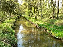
that secured the banks have largely rotted away, the canal has become a near-natural waterway. The canal runs through the deciduous woods of the
Barnbruch, which provides shade. This prevents the growth of weeds in the river bed, unlike the river Aller which is unshaded in most places.
167:. The canal is only about 5 m wide and 1 m deep. To appreciate the feat achieved by its builders it should be borne in mind that, at the time, there was almost no technical equipment and workers had to excavate the channel by hand using shovels.
183:
Allerkanal, erbaut 1860-63, Kostenaufwand 45.000 Thaler, den Bauern der Allerdörfer von
Wolfsburg bis Diekhorst, die ihn schufen, dem Wasserbauinspektor August Hess in Celle, der ihn baute und den Männern, die ihn betreuten zum
205:
report of 2004 assessed the chemical water contamination of the Aller Canal along with the river Aller itself as moderately polluted (water quality class II). Because the
193:, and the farmers of the Aller villages from Wolfsburg to Diekhorst who created it, hydraulic engineer, August Hess, in Celle, who designed it, and the men he oversaw."
283:
163:
for the regulation of the Aller. Its purpose was to control the spring floods in the Aller valley and to assist in draining the former swampland of the
95:. Here the Aller divides itself between its natural river channel and the canal. The canal runs in an almost straight line through the wetland of the
322:
337:
332:
234:
115:. The river flows parallel and north of the canal by several kilometres and, in this flat area of the Aller's old
103:
where it passes the town to the south. West of
Gifhorn the canal uses the upgraded and widened stream bed of the
111:, it rejoins the Aller. About a kilometre before that the water of the canal drops by about a metre over a
239:
67:. The nearly straight canal carries water from the Aller more quickly than the river itself can in its
342:
108:
327:
160:
156:
151:
The construction of the Aller Canal between 1860 and 1863 stemmed from a state treaty between
83:
The Aller Canal was completed in 1863 after a three-year construction period. It begins near
274:
219:
64:
40:
229:
131:
116:
72:
316:
202:
189:...which means: "To commemorate the Aller Canal, built 1860-63 at a cost of 45,000
92:
48:
261:
des
Niedersächsischen Landesbetriebs für Wasserwirtschaft, Küsten- und Naturschutz
224:
104:
27:
298:
285:
164:
144:
96:
88:
84:
52:
17:
120:
60:
275:
Water quality report Aller /source 2004 from the state of Lower Saxony
206:
175:
152:
139:
100:
68:
56:
190:
138:
130:
47:) is a canal built in the mid-19th century in the German state of
170:
A monument to the construction was erected by the canal between
112:
51:. The canal is 18 kilometres (11 mi) long and runs between
107:
and, 5 km west of
Gifhorn, near Brenneckenbrück on the
59:. It was built to protect agricultural land from
178:-Winkel. It carries the following inscription:
123:which reduce the water velocity in the river.
91:, where it is joined by the tributary of the
8:
135:Monument to the construction of the canal
26:
259:Gewässergütebericht Aller / Quelle 2004
251:
71:course through this section of the old
7:
25:
1:
359:
31:Course of the Aller Canal
87:just beyond the city of
143:The Aller Canal in the
119:, forms tightly-spaced
323:Canals in Lower Saxony
148:
136:
44:
32:
338:Canals opened in 1863
142:
134:
30:
235:Rötgesbütteler Riede
299:52.4778°N 10.4653°E
295: /
333:Gifhorn (district)
240:Vollbütteler Riede
161:Duchy of Brunswick
157:Kingdom of Hanover
149:
137:
33:
16:(Redirected from
350:
310:
309:
307:
306:
305:
304:52.4778; 10.4653
300:
296:
293:
292:
291:
288:
262:
256:
201:The Lower Saxon
21:
358:
357:
353:
352:
351:
349:
348:
347:
313:
312:
303:
301:
297:
294:
289:
286:
284:
282:
281:
271:
266:
265:
257:
253:
248:
216:
199:
172:Brenneckenbrück
129:
81:
23:
22:
15:
12:
11:
5:
356:
354:
346:
345:
340:
335:
330:
325:
315:
314:
279:
278:
270:
269:External links
267:
264:
263:
250:
249:
247:
244:
243:
242:
237:
232:
227:
222:
215:
212:
198:
195:
187:
186:
128:
125:
117:glacial valley
80:
77:
73:glacial valley
24:
14:
13:
10:
9:
6:
4:
3:
2:
355:
344:
341:
339:
336:
334:
331:
329:
326:
324:
321:
320:
318:
311:
308:
276:
273:
272:
268:
260:
255:
252:
245:
241:
238:
236:
233:
231:
228:
226:
223:
221:
218:
217:
213:
211:
208:
204:
203:water quality
197:Water quality
196:
194:
192:
185:
181:
180:
179:
177:
173:
168:
166:
162:
158:
154:
146:
141:
133:
126:
124:
122:
118:
114:
110:
106:
102:
98:
94:
90:
86:
78:
76:
74:
70:
66:
63:by the river
62:
58:
54:
50:
46:
42:
38:
29:
19:
280:
258:
254:
200:
188:
182:
171:
169:
150:
127:Construction
93:Kleine Aller
82:
49:Lower Saxony
36:
34:
343:Aller basin
302: /
277:(pdf, 1 MB)
230:Mühlenriede
225:Hehlenriede
214:Tributaries
105:Hehlenriede
37:Aller Canal
317:Categories
290:10°27′55″E
287:52°28′40″N
246:References
99:as far as
69:meandering
45:Allerkanal
18:Allerkanal
328:Wolfsburg
165:Barnbruch
145:Barnbruch
97:Barnbruch
89:Wolfsburg
85:Weyhausen
53:Wolfsburg
207:fascines
184:Gedenken
121:meanders
61:flooding
191:thalers
176:Gifhorn
153:Prussia
147:wetland
101:Gifhorn
57:Gifhorn
155:, the
41:German
220:Aller
109:B 188
79:Route
65:Aller
174:and
159:and
113:weir
55:and
35:The
319::
75:.
43::
39:(
20:)
Text is available under the Creative Commons Attribution-ShareAlike License. Additional terms may apply.