54:
66:
1131:
412:
1533:
84:
1096:
451:, Arghakhanchi District had a population of 197,632; 86,266 male and 111,366 female. The total number of households was 46,835 and the average household size 4.22 on the basis of usual place of residence. The sex ratio (number of males per 100 females) was 77.5 and population density was 166.
304:. Argha (Nepali:अर्घा) was the name given to ritual offerings made at the former principality's main Bhagwati Temple. Khanchi may come from the word Khajanchi (Nepali:खजाञ्चि) or tax collector since the center of the latter principality was known for its tax office. Both were two of the
594:
The major rivers of the district are Bangi Khola, Bangsari Khola, Mathurabesi Khola, Banganga Khola, Durga Khola, Sita Khola, Khakabesi Khola, Rangsing Khola, Ratne Khola, Jhimruk Khola, Khankbesi Khola and Thada Khola. Thada lake and
Sengleng lake are the major lakes of the district.
582:
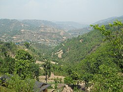
Arghakhanchi lies between 27'45"N and 28'6"N latitude, and 80'45"E to 83'23"E longitude. It covers 1,193 km. The altitude of the district varies from 305 to 2515 meter above the sea level. 68% of the district is in the mountainous
53:
243:
255:
1421:
288:
in the west. The district also covers 4.18 km of road connecting
Kapilvastu and Bhalubang, Lalmatiya, Dang with Rapti River as Mahendra Highway or Easy-West Highway.
65:
1990:
1064:
957:
1414:
1946:
946:
924:
935:
1407:
816:
1168:
823:
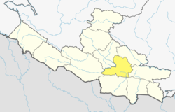
272:. The district covers an area of 1,193 km (461 sq mi) and has a population (2011) of 197,632. Its neighboring districts are
1057:
981:
855:
136:
126:
1985:
1050:
721:
which is the headquarters of
Arghakhanchi district. It is almost 300 km (190 mi) southwest of Nepal's capital of
1147:
696:
1388:
1139:
1157:
706:
1341:
1152:
701:
570:
The latest update of population of
Arghakhanchi district according to 2021 Nepal census is noted as 177,086 with
976:, . Forest & Landscape Development and Environment Series 2-2005 and CFC-TIS Document Series No.110., 2005,
1640:
76:
737:
733:
1635:
1454:
1384:
1231:
1102:
1884:
1874:
1864:
1776:
1708:
1670:
1494:
1251:
1356:
1316:
591:. Elevations range from 305 to 2575 m above sea level and about 40% of the total area is forested.
561:
970:
The Map of
Potential Vegetation of Nepal - a forestry/agroecological/biodiversity classification system
1771:
1484:
1191:
827:
498:
424:
1932:
1912:
1786:
1499:
1276:
787:
567:
Literacy: 72.5% could read and write, 2.2% could only read and 25.3% could neither read nor write.
475:
281:
1130:
1811:
1655:
1645:
1630:
1610:
1572:
1514:
1509:
1489:
1434:
1430:
752:
601:
571:
203:
96:
44:
1917:
1844:
1723:
1665:
1577:
1567:
1519:
1459:
1206:
977:
811:
809:
807:
775:
656:
553:
549:
448:
1927:
1902:
1897:
1869:
1854:
1829:
1821:
1801:
1766:
1748:
1738:
1733:
1713:
1703:
1688:
1680:
1650:
1625:
1620:
1615:
1602:
1587:
1582:
1549:
1504:
1474:
740:
615:
584:
518:
463:
313:
285:
261:
101:
1907:
1892:
1791:
1728:
1718:
1693:
1660:
1592:
1479:
744:
455:
248:
238:
208:
677:
The district consists of six municipalities, out of which three are urban municipalities
1849:
1839:
1834:
1806:
1796:
1781:
1761:
1698:
1562:
1469:
1446:
557:
459:
317:
305:
277:
273:
859:
312:
Basin. In 1786 A.D. (1843 BS) during the unification of Nepal the two were annexed by
1979:
1922:
1859:
1557:
1464:
1371:
1301:
1296:
1201:
779:
588:
526:
309:
1538:
1399:
1196:
1120:
1110:
1084:
968:
756:
748:
718:
691:
681:
542:
510:
502:
494:
467:
269:
111:
420:
1361:
1321:
1211:
534:
881:
1528:
1351:
1281:
767:
641:
195:
191:
1961:
1948:
1266:
1246:
1236:
1226:
1221:
791:
728:
There are many small villages in the district, including Mareng, Bhagawati,
722:
538:
186:
1095:
17:
444:
In 2001, the population was 208,391. In 1991, the population was 180,884.
1346:
1331:
1306:
1286:
1181:
1115:
771:
763:
686:
1042:
1336:
1271:
1241:
1216:
1186:
759:
729:
530:
522:
486:
342:
301:
419:
Graphs are unavailable due to technical issues. There is more info on
219:
1326:
1311:
1291:
1261:
1256:
1176:
783:
514:
490:
902:
1438:
1366:
506:
482:
320:. Arghakhanchi became a separate district in 1961 A.D. (2018 BS).
297:
265:
89:
1030:
471:
1403:
1046:
1037:
817:"National Population and Housing Census 2011(National Report)"
405:
337:
296:
The district consists of two pre-unification principalities
794:, Thada, Pharasawa Takura, Amarai, Pattharkot, and Jukena.
316:. Later the merger was renamed “Arghakhanchi” and added to
70:
1003:
1006:. Ministry of Federal Affairs and General Administration
826:. Government of Nepal. November 3, 2012. Archived from
1883:
1820:
1747:
1679:
1601:
1548:
1445:
1166:
1138:
1101:
214:
202:
185:
177:
169:
164:
156:
148:
143:
132:
122:
117:
107:
95:
75:
32:
1415:
1058:
8:
328:
1422:
1408:
1400:
1065:
1051:
1043:
897:
895:
850:
848:
327:
29:
597:
803:
213:
201:
184:
163:
142:
116:
106:
74:
62:
50:
1991:Districts of Nepal established in 1962
454:As their first language, 97.5% spoke
247:
176:
168:
155:
147:
131:
121:
94:
7:
308:(24 principalities) centred in the
152:1,199 km (463 sq mi)
27:District in Lumbini Province, Nepal
717:The major town in the district is
25:
620:below 300 meters (1,000 ft)
1531:
1129:
1094:
882:"NEPAL: Administrative Division"
410:
82:
64:
52:
58:Valley in Arghakhanchi district
858:. 28 June 2012. Archived from
268:. The district headquarter is
1:
697:Chhatradev Rural Municipality
525:, 0.5% Sanyasi/Dasnami, 0.4%
260:) is one of the districts of
1038:Arghakhanchi.com news portal
824:Central Bureau of Statistics
481:Ethnicity/caste: 32.8% were
707:Malarani Rural Municipality
2007:
1526:
1380:
1127:
1092:
1080:
702:Panini Rural Municipality
692:Bhumikasthan Municipality
682:Sandhikharka Municipality
437:
403:
355:—
242:
63:
51:
42:
738:Chhatragunj Arghakhanchi
663:6,400 to 9,800 ft.
648:3,300 to 6,600 ft.
633:1,000 to 3,300 ft.
790:, Khanadaha, Pali, and
734:Chhatradev Arghakhanchi
587:and the rest is in the
181:160/km (430/sq mi)
438:Source: Citypopulation
127:Coordination committee
1986:Arghakhanchi District
1962:28.00083°N 83.24667°E
1074:Arghakhanchi District
886:www.citypopulation.de
687:Sitganga Municipality
661:2,000 to 3,000 meters
646:1,000 to 2,000 meters
578:Geography and climate
548:Religion: 97.0% were
329:Historical population
249:[ʌɾɡakʰãt͡si]
34:Arghākhā̃chī District
1389:rural municipalities
1140:Rural municipalities
178: • Density
1958: /
631:300 to 1,000 meters
447:At the time of the
330:
282:Kapilvastu District
1967:28.00083; 83.24667
1004:"Local level body"
956:NepalMap Literacy
945:NepalMap Religion
923:NepalMap Language
713:Towns and villages
572:population density
170: • Total
149: • Total
1941:
1940:
1397:
1396:
1392:
903:"Nepal Districts"
670:
669:
545:and 0.1% others.
449:2011 Nepal census
442:
441:
432:
431:
284:in the south and
244:अर्घाखाँची जिल्ला
232:
231:
157: • Rank
133: • Body
123: • Type
37:अर्घाखाँची जिल्ला
16:(Redirected from
1998:
1973:
1972:
1970:
1969:
1968:
1963:
1959:
1956:
1955:
1954:
1951:
1541:
1536:
1535:
1534:
1424:
1417:
1410:
1401:
1382:
1133:
1098:
1067:
1060:
1053:
1044:
1034:
1033:
1031:Official website
1016:
1015:
1013:
1011:
1000:
994:
993:
992:
990:
975:
965:
959:
954:
948:
943:
937:
932:
926:
921:
915:
914:
912:
910:
899:
890:
889:
878:
872:
871:
869:
867:
862:on June 18, 2010
852:
843:
842:
840:
838:
832:
821:
813:
606:Elevation range
598:
585:Mahabharat Range
414:
413:
406:
344:
339:
331:
262:Lumbini Province
259:
258:
257:
251:
246:
228:
225:
223:
221:
204:Main Language(s)
102:Lumbini Province
88:
86:
85:
68:
56:
30:
21:
2006:
2005:
2001:
2000:
1999:
1997:
1996:
1995:
1976:
1975:
1966:
1964:
1960:
1957:
1952:
1949:
1947:
1945:
1944:
1942:
1937:
1879:
1816:
1743:
1675:
1597:
1544:
1537:
1532:
1530:
1524:
1441:
1428:
1398:
1393:
1376:
1162:
1134:
1125:
1099:
1088:
1076:
1071:
1029:
1028:
1025:
1020:
1019:
1009:
1007:
1002:
1001:
997:
988:
986:
984:
973:
967:
966:
962:
955:
951:
944:
940:
934:NepalMap Caste
933:
929:
922:
918:
908:
906:
901:
900:
893:
880:
879:
875:
865:
863:
854:
853:
846:
836:
834:
833:on May 25, 2013
830:
819:
815:
814:
805:
800:
715:
675:
662:
647:
632:
628:Upper Tropical
580:
433:
428:
415:
411:
326:
294:
254:
253:
252:
220:daoarghakhanchi
218:
83:
81:
71:
59:
47:
38:
35:
28:
23:
22:
15:
12:
11:
5:
2004:
2002:
1994:
1993:
1988:
1978:
1977:
1939:
1938:
1936:
1935:
1930:
1925:
1920:
1915:
1910:
1905:
1900:
1895:
1889:
1887:
1881:
1880:
1878:
1877:
1872:
1867:
1862:
1857:
1852:
1847:
1842:
1837:
1832:
1826:
1824:
1818:
1817:
1815:
1814:
1809:
1804:
1799:
1794:
1789:
1784:
1779:
1774:
1769:
1764:
1759:
1753:
1751:
1745:
1744:
1742:
1741:
1736:
1731:
1726:
1721:
1716:
1711:
1706:
1701:
1696:
1691:
1685:
1683:
1677:
1676:
1674:
1673:
1668:
1663:
1658:
1653:
1648:
1643:
1638:
1636:Kavrepalanchok
1633:
1628:
1623:
1618:
1613:
1607:
1605:
1599:
1598:
1596:
1595:
1590:
1585:
1580:
1575:
1570:
1565:
1560:
1554:
1552:
1546:
1545:
1543:
1542:
1527:
1525:
1523:
1522:
1517:
1512:
1507:
1502:
1497:
1492:
1487:
1482:
1477:
1472:
1467:
1462:
1457:
1451:
1449:
1443:
1442:
1429:
1427:
1426:
1419:
1412:
1404:
1395:
1394:
1385:municipalities
1381:
1378:
1377:
1375:
1374:
1369:
1364:
1359:
1354:
1349:
1344:
1339:
1334:
1329:
1324:
1319:
1314:
1309:
1304:
1299:
1294:
1289:
1284:
1279:
1274:
1269:
1264:
1259:
1254:
1249:
1244:
1239:
1234:
1229:
1224:
1219:
1214:
1209:
1204:
1199:
1194:
1189:
1184:
1179:
1173:
1171:
1164:
1163:
1161:
1160:
1155:
1150:
1144:
1142:
1136:
1135:
1128:
1126:
1124:
1123:
1118:
1113:
1107:
1105:
1103:Municipalities
1100:
1093:
1090:
1089:
1081:
1078:
1077:
1072:
1070:
1069:
1062:
1055:
1047:
1041:
1040:
1035:
1024:
1023:External links
1021:
1018:
1017:
995:
982:
960:
949:
938:
927:
916:
905:. statoids.com
891:
873:
844:
802:
801:
799:
796:
714:
711:
710:
709:
704:
699:
694:
689:
684:
674:
673:Administration
671:
668:
667:
664:
659:
653:
652:
649:
644:
638:
637:
634:
629:
625:
624:
621:
618:
611:
610:
607:
604:
579:
576:
513:, 0.9% Gharti/
440:
439:
435:
434:
430:
429:
418:
416:
409:
404:
401:
400:
397:
394:
390:
389:
386:
383:
379:
378:
375:
372:
368:
367:
364:
361:
357:
356:
353:
350:
346:
345:
340:
335:
325:
322:
318:Gulmi District
306:Chaubisi rajya
293:
290:
280:in the north,
230:
229:
216:
212:
211:
206:
200:
199:
189:
183:
182:
179:
175:
174:
171:
167:
166:
162:
161:
158:
154:
153:
150:
146:
145:
141:
140:
139:, Arghākhānchī
134:
130:
129:
124:
120:
119:
115:
114:
109:
105:
104:
99:
93:
92:
79:
73:
72:
69:
61:
60:
57:
49:
48:
43:
40:
39:
36:
33:
26:
24:
14:
13:
10:
9:
6:
4:
3:
2:
2003:
1992:
1989:
1987:
1984:
1983:
1981:
1974:
1971:
1934:
1931:
1929:
1926:
1924:
1921:
1919:
1916:
1914:
1911:
1909:
1906:
1904:
1901:
1899:
1896:
1894:
1891:
1890:
1888:
1886:
1885:Sudurpashchim
1882:
1876:
1875:Western Rukum
1873:
1871:
1868:
1866:
1863:
1861:
1858:
1856:
1853:
1851:
1848:
1846:
1843:
1841:
1838:
1836:
1833:
1831:
1828:
1827:
1825:
1823:
1819:
1813:
1810:
1808:
1805:
1803:
1800:
1798:
1795:
1793:
1790:
1788:
1785:
1783:
1780:
1778:
1777:Eastern Rukum
1775:
1773:
1770:
1768:
1765:
1763:
1760:
1758:
1755:
1754:
1752:
1750:
1746:
1740:
1737:
1735:
1732:
1730:
1727:
1725:
1722:
1720:
1717:
1715:
1712:
1710:
1707:
1705:
1702:
1700:
1697:
1695:
1692:
1690:
1687:
1686:
1684:
1682:
1678:
1672:
1671:Sindhupalchok
1669:
1667:
1664:
1662:
1659:
1657:
1654:
1652:
1649:
1647:
1644:
1642:
1639:
1637:
1634:
1632:
1629:
1627:
1624:
1622:
1619:
1617:
1614:
1612:
1609:
1608:
1606:
1604:
1600:
1594:
1591:
1589:
1586:
1584:
1581:
1579:
1576:
1574:
1571:
1569:
1566:
1564:
1561:
1559:
1556:
1555:
1553:
1551:
1547:
1540:
1529:
1521:
1518:
1516:
1513:
1511:
1508:
1506:
1503:
1501:
1498:
1496:
1495:Sankhuwasabha
1493:
1491:
1488:
1486:
1483:
1481:
1478:
1476:
1473:
1471:
1468:
1466:
1463:
1461:
1458:
1456:
1453:
1452:
1450:
1448:
1444:
1440:
1436:
1432:
1425:
1420:
1418:
1413:
1411:
1406:
1405:
1402:
1390:
1386:
1379:
1373:
1372:Thulo Pokhara
1370:
1368:
1365:
1363:
1360:
1358:
1355:
1353:
1350:
1348:
1345:
1343:
1340:
1338:
1335:
1333:
1330:
1328:
1325:
1323:
1320:
1318:
1315:
1313:
1310:
1308:
1305:
1303:
1300:
1298:
1295:
1293:
1290:
1288:
1285:
1283:
1280:
1278:
1275:
1273:
1270:
1268:
1265:
1263:
1260:
1258:
1255:
1253:
1250:
1248:
1245:
1243:
1240:
1238:
1235:
1233:
1230:
1228:
1225:
1223:
1220:
1218:
1215:
1213:
1210:
1208:
1205:
1203:
1200:
1198:
1195:
1193:
1190:
1188:
1185:
1183:
1180:
1178:
1175:
1174:
1172:
1170:
1165:
1159:
1156:
1154:
1151:
1149:
1146:
1145:
1143:
1141:
1137:
1132:
1122:
1119:
1117:
1114:
1112:
1109:
1108:
1106:
1104:
1097:
1091:
1087:
1086:
1082:Headquarter:
1079:
1075:
1068:
1063:
1061:
1056:
1054:
1049:
1048:
1045:
1039:
1036:
1032:
1027:
1026:
1022:
1005:
999:
996:
985:
983:87-7903-210-9
979:
972:
971:
964:
961:
958:
953:
950:
947:
942:
939:
936:
931:
928:
925:
920:
917:
904:
898:
896:
892:
887:
883:
877:
874:
861:
857:
851:
849:
845:
829:
825:
818:
812:
810:
808:
804:
797:
795:
793:
789:
785:
781:
777:
773:
769:
765:
761:
758:
754:
750:
746:
742:
739:
735:
731:
726:
724:
720:
712:
708:
705:
703:
700:
698:
695:
693:
690:
688:
685:
683:
680:
679:
678:
672:
665:
660:
658:
655:
654:
650:
645:
643:
640:
639:
635:
630:
627:
626:
622:
619:
617:
613:
612:
608:
605:
603:
600:
599:
596:
592:
590:
589:Siwalik Hills
586:
577:
575:
574:of 148.4/km.
573:
568:
565:
563:
559:
555:
551:
546:
544:
540:
536:
532:
529:, 0.2% Terai
528:
524:
520:
516:
512:
509:/Dholi, 2.8%
508:
504:
500:
496:
492:
488:
484:
479:
477:
473:
469:
465:
461:
457:
452:
450:
445:
436:
426:
425:MediaWiki.org
422:
417:
408:
407:
402:
398:
395:
392:
391:
387:
384:
381:
380:
376:
373:
370:
369:
365:
362:
359:
358:
354:
351:
348:
347:
341:
336:
333:
332:
323:
321:
319:
315:
311:
307:
303:
299:
291:
289:
287:
283:
279:
276:in the east,
275:
271:
267:
263:
256:
250:
245:
240:
236:
227:
217:
210:
207:
205:
197:
193:
190:
188:
180:
172:
159:
151:
138:
135:
128:
125:
113:
110:
103:
100:
98:
91:
80:
78:
67:
55:
46:
41:
31:
19:
1943:
1757:Arghakhanchi
1756:
1539:Nepal portal
1121:Bhumikasthan
1111:Sandhikharka
1085:Sandhikharka
1083:
1073:
1008:. Retrieved
998:
987:, retrieved
969:
963:
952:
941:
930:
919:
907:. Retrieved
885:
876:
864:. Retrieved
860:the original
835:. Retrieved
828:the original
757:Sandhikharka
727:
719:Sandhikharka
716:
676:
602:Climate zone
593:
581:
569:
566:
547:
483:Hill Brahmin
480:
453:
446:
443:
324:Demographics
295:
270:Sandhikharka
235:Arghakhanchi
234:
233:
112:Sandhikharka
1965: /
1787:Kapilavastu
1485:Okhaldhunga
1362:Subarnakhal
1342:Pokharathok
1212:Chhatraganj
1148:Chhatradev
856:"Districts"
837:November 3,
666: 0.2%
642:Subtropical
623: 0.2%
421:Phabricator
334:Census year
18:Arghakhachi
1980:Categories
1953:83°14′48″E
1933:Kanchanpur
1913:Dadeldhura
1515:Tehrathum
1500:Solukhumbu
1352:Simalapani
1282:Khanchikot
798:References
768:Khanchikot
609:% of area
165:Population
118:Government
1812:Rupandehi
1656:Ramechhap
1646:Makwanpur
1631:Kathmandu
1611:Bhaktapur
1573:Mahottari
1510:Taplejung
1490:Panchthar
1435:Districts
1431:Provinces
1267:Kimadanda
1247:Gorkhunga
1237:Dhatiwang
1232:Dharapani
1227:Dhanchaur
1222:Dhakawang
1207:Bhagawati
1010:1 October
909:18 August
866:18 August
792:Dhatiwang
753:Dharapani
723:Kathmandu
657:Temperate
562:Christian
560:and 0.1%
474:and 0.1%
192:UTC+05:45
187:Time zone
108:Admin HQ.
1950:28°0′3″N
1918:Darchula
1845:Jajarkot
1724:Nawalpur
1666:Sindhuli
1641:Lalitpur
1578:Rautahat
1568:Dhanusha
1520:Udayapur
1460:Dhankuta
1391:of Nepal
1383:List of
1347:Siddhara
1332:Pathauti
1307:Malarani
1287:Khandaha
1252:Hansapur
1182:Arghatos
1158:Malarani
1116:Sitganga
776:Phudbang
774:, Kura,
772:Kimadada
764:Dibharna
616:Tropical
554:Buddhist
519:Musalman
493:, 11.3%
489:, 18.0%
485:, 18.2%
97:Province
45:District
1928:Kailali
1903:Bajhang
1898:Baitadi
1870:Surkhet
1855:Kalikot
1830:Dailekh
1822:Karnali
1802:Pyuthan
1767:Bardiya
1749:Lumbini
1739:Tanahun
1734:Syangja
1714:Mustang
1704:Lamjung
1689:Baglung
1681:Gandaki
1651:Nuwakot
1626:Dolakha
1621:Dhading
1616:Chitwan
1603:Bagmati
1588:Sarlahi
1583:Saptari
1550:Madhesh
1505:Sunsari
1475:Khotang
1455:Bhojpur
1357:Sitapur
1337:Pathona
1317:Nuwakot
1272:Kerunga
1242:Dhikura
1217:Chidika
1187:Asurkot
1167:Former
989:Nov 22,
760:Dhikura
730:Asurkot
556:, 0.9%
552:, 1.9%
541:, 0.1%
537:, 0.1%
533:, 0.1%
531:Brahmin
523:Thakuri
521:, 0.6%
517:, 0.9%
505:, 3.2%
501:, 3.4%
497:, 6.1%
487:Chhetri
470:, 0.2%
466:, 0.2%
464:Kumhali
462:, 0.5%
458:, 1.3%
423:and on
396:177,200
385:197,632
374:208,391
363:180,884
352:157,304
343:±% p.a.
310:Gandaki
302:Khanchi
292:History
286:Pyuthan
215:Website
173:197,632
77:Country
1908:Bajura
1893:Achham
1865:Salyan
1792:Parasi
1729:Parbat
1719:Myagdi
1709:Manang
1694:Gorkha
1661:Rasuwa
1593:Siraha
1480:Morang
1327:Panena
1312:Mareng
1302:Maidan
1297:Khilji
1292:Khidim
1262:Juluke
1257:Jukena
1202:Bangla
1192:Balkot
1177:Adguri
1153:Panini
980:
784:Adguri
780:Bangla
745:Balkot
741:Lamchi
651:49.1%
636:50.5%
614:Lower
558:Muslim
527:Gurung
515:Bhujel
456:Nepali
399:−1.09%
388:−0.53%
377:+1.43%
366:+1.41%
314:Gorkha
239:Nepali
209:Nepali
87:
1850:Jumla
1840:Humla
1835:Dolpa
1807:Rolpa
1797:Palpa
1782:Gulmi
1762:Banke
1699:Kaski
1563:Parsa
1470:Jhapa
1447:Koshi
1439:Nepal
1367:Thada
1277:Khana
1197:Bangi
974:(PDF)
831:(PDF)
820:(PDF)
788:Khana
749:Bangi
550:Hindu
543:Tharu
539:Gaine
511:Newar
507:Damai
503:Kumal
499:Sarki
491:Magar
468:Newar
460:Magar
393:2021
382:2011
371:2001
360:1991
349:1981
298:Argha
278:Gulmi
274:Palpa
266:Nepal
222:.moha
90:Nepal
1923:Doti
1860:Mugu
1772:Dang
1558:Bara
1465:Ilam
1433:and
1387:and
1322:Pali
1169:VDCs
1012:2018
991:2013
978:ISBN
911:2012
868:2012
839:2012
535:Badi
495:Kami
476:Kham
472:Urdu
338:Pop.
300:and
224:.gov
144:Area
1437:of
264:in
226:.np
196:NPT
160:077
137:DCC
1982::
894:^
884:.
847:^
822:.
806:^
786:,
782:,
778:,
770:,
766:,
762:,
755:,
751:,
747:,
743:,
736:,
732:,
725:.
564:.
478:.
241::
1423:e
1416:t
1409:v
1066:e
1059:t
1052:v
1014:.
913:.
888:.
870:.
841:.
427:.
237:(
198:)
194:(
20:)
Text is available under the Creative Commons Attribution-ShareAlike License. Additional terms may apply.