109:
347:
747:
339:
96:
890:
734:
74:
716:
1224:
964:
64:
49:
675:
706:
116:
462:) with very warm summers and cool winters. The average annual temperature in Asakuchi is 15.6 °C. The average annual rainfall is 1289 mm with September as the wettest month. The temperatures are highest on average in July, at around 27.1 °C, and lowest in January, at around 4.9 °C.
410:
to the south. It is mostly hilly, with Mount Yosho and Mount
Chikurinji in the north, Mount Abe in the northwest, and Mount Ryuo in the center. The southern part of the city is close to the Mizushima industrial area (approximately 10 km kilometers and the Fukuyama industrial area (approximately 20
659:
Asakuchi has seven public elementary schools and three public junior high schools operated by the city government and one private junior high school. The city has one public high school operated by the
Okayama prefectural Board of Education and two private high schools.
605:
with the creation of the modern municipalities system on June 1, 1889. Yorishima was elevated to town status on
February 6, 1901 and Kamogata on October 25, 1925. On March 21, 2006 Kamogata and Yorishima merged with the town of
626:
city council of 16 members. Asakuchi, together with the town of Satoshō contributes two members to the
Okayama Prefectural Assembly. In terms of national politics, the city is part of the Okayama 3rd district of the
108:
1290:
1261:
889:
1280:
1208:
140:
879:
643:
Asakuchi is a regional commercial center with a mixed economy of agriculture and light manufacturing. The city is also increasing a
628:
95:
346:
1295:
456:
284:
394:
of 500 persons per km. The total area of the city is 66.464 square kilometres (25.662 sq mi). The headquarters of the
73:
963:
1254:
857:
63:
1285:
1084:
678:
602:
338:
1247:
1178:
1108:
907:
452:
289:
48:
1166:
1142:
184:
172:
709:
823:
1190:
1125:
1096:
1072:
738:
719:
682:
1154:
872:
972:
200:
944:
648:
435:
268:
1223:
193:
1046:
949:
893:
598:
425:
419:
391:
379:
205:
1147:
578:
470:
Per
Japanese census data, the population of Asakuchi has remained stable for the past 60 years.
1036:
1026:
607:
594:
590:
189:
1231:
939:
934:
865:
692:
688:
430:
1159:
1135:
440:
407:
375:
39:
586:
1101:
1006:
926:
1274:
1195:
1113:
644:
632:
619:
1077:
764:
834:
785:
589:
confirm that the area has been inhabited since prehistoric times. Following the
1089:
623:
387:
1118:
155:
142:
1183:
980:
733:
674:
259:
751:
1171:
395:
1130:
1056:
1041:
1016:
917:
902:
279:
3050 Rokujō-in Naka, Kamogata-machi, Asakuchi-shi, Okayama-ken 719-0295
849:
1051:
1021:
996:
582:
326:
264:
406:
Asakuchi is in the southwestern
Okayama Prefecture, bordered by the
1031:
1011:
810:
746:
383:
345:
337:
301:
177:
487:
861:
610:(also from Asakuchi District) to form the city of Asakuchi.
482:
386:. As of 1 March 2023, the city had an estimated
1235:
622:
form of government with a directly elected mayor and a
1065:
989:
971:
925:
916:
322:
295:
283:
275:
258:
250:
242:
237:
229:
224:
216:
211:
199:
183:
171:
21:
365:
1230:This Okayama Prefecture location article is a
359:
27:
1255:
873:
8:
473:
811:"Kasaoka Asakuchi city official statistics"
1262:
1248:
922:
880:
866:
858:
786:"山陽高がスイーツ甲子園特別賞 世界平和への願い込めたケーキ | 中国新聞デジタル"
673:
472:
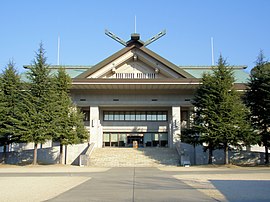
342:Konkokyo Headquarters Central Worship Hall
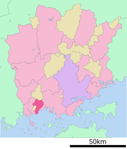
88:Location of Asakuchi in Okayama Prefecture
18:
790:山陽高がスイーツ甲子園特別賞 世界平和への願い込めたケーキ | 中国新聞デジタル
777:
317:
294:
282:
274:
257:
236:
223:
210:
170:
135:
101:
85:
57:
45:
1209:List of mergers in Okayama Prefecture
577:The Asakuchi area is part of ancient
390:of 33,322 in 14,409 households and a
321:
249:
241:
233:66.46 km (25.66 sq mi)
228:
215:
198:
182:
92:
7:
1220:
1218:
220:Yasuhiko Kuriyama (since April 2010)
350:Aerial view of Asakuchi city center
1234:. You can help Knowledge (XXG) by
14:
1291:Populated coastal places in Japan
1222:
962:
888:
745:
732:
714:
704:
115:
114:
107:
94:
72:
62:
47:
850:Asakuchi City official website
835:Asakuchi population statistics
1:
457:Köppen climate classification
1281:Cities in Okayama Prefecture
366:
1312:
1217:
759:Noted people from Asakuchi
603:Asakuchi District, Okayama
1206:
960:
900:
500:—
453:humid subtropical climate
398:religion is in Asakuchi.
360:
332:
318:
313:
309:
254:500/km (1,300/sq mi)
136:
102:
93:
86:
58:
46:
37:
28:
601:were established within
415:Adjoining municipalities
1296:Okayama geography stubs
739:City of Tea Tree Gully
351:
343:
156:34.52472°N 133.58750°E
824:Asakuchi climate data
813:(in Japanese). Japan.
720:National Route 2
474:Historical population
349:
341:
251: • Density
53:Asakuchi city office
475:
269:Japan Standard Time
161:34.52472; 133.58750
152: /
894:Okayama Prefecture
741:, Australia (2007)
593:, the villages of
420:Okayama Prefecture
392:population density
380:Okayama Prefecture
352:
344:
243: • Total
230: • Total
217: • Mayor
1286:Asakuchi, Okayama
1243:
1242:
1215:
1214:
1085:Asakuchi District
958:
957:
911:
710:San'yō Expressway
591:Meiji restoration
570:
569:
336:
335:
276:City hall address
1303:
1264:
1257:
1250:
1226:
1219:
1179:Tsukubo District
1109:Katsuta District
966:
923:
905:
892:
882:
875:
868:
859:
854:
837:
832:
826:
821:
815:
814:
807:
801:
800:
798:
797:
782:
767:, movie director
750:
749:
737:
736:
718:
717:
708:
707:
683:San'yō Main Line
677:
489:
484:
476:
373:
372:
369:
363:
362:
305:
304:
302:Official website
167:
166:
164:
163:
162:
157:
153:
150:
149:
148:
145:
118:
117:
111:
98:
76:
66:
51:
32:
31:
30:
19:
1311:
1310:
1306:
1305:
1304:
1302:
1301:
1300:
1271:
1270:
1269:
1268:
1216:
1211:
1202:
1167:Tomata District
1143:Maniwa District
1061:
985:
967:
954:
912:
896:
886:
852:
846:
841:
840:
833:
829:
822:
818:
809:
808:
804:
795:
793:
784:
783:
779:
774:
761:
744:
731:
728:
715:
705:
701:
671:
666:
657:
651:and Kurashiki.
641:
618:Asakuchi has a
616:
579:Bitchū Province
575:
468:
451:Asakuchi has a
449:
417:
408:Seto Inland Sea
404:
370:
357:
300:
299:
192:
160:
158:
154:
151:
146:
143:
141:
139:
138:
132:
131:
130:
129:
126:
125:
124:
123:
119:
89:
82:
81:
80:
79:
70:
69:
54:
42:
33:
26:
24:
17:
12:
11:
5:
1309:
1307:
1299:
1298:
1293:
1288:
1283:
1273:
1272:
1267:
1266:
1259:
1252:
1244:
1241:
1240:
1227:
1213:
1212:
1207:
1204:
1203:
1201:
1200:
1199:
1198:
1188:
1187:
1186:
1176:
1175:
1174:
1164:
1163:
1162:
1152:
1151:
1150:
1140:
1139:
1138:
1133:
1123:
1122:
1121:
1116:
1106:
1105:
1104:
1094:
1093:
1092:
1082:
1081:
1080:
1069:
1067:
1063:
1062:
1060:
1059:
1054:
1049:
1044:
1039:
1034:
1029:
1024:
1019:
1014:
1009:
1004:
999:
993:
991:
987:
986:
984:
983:
977:
975:
969:
968:
961:
959:
956:
955:
953:
952:
947:
942:
937:
931:
929:
920:
914:
913:
901:
898:
897:
887:
885:
884:
877:
870:
862:
856:
855:
845:
844:External links
842:
839:
838:
827:
816:
802:
776:
775:
773:
770:
769:
768:
760:
757:
756:
755:
754:, China (2009)
742:
727:
724:
723:
722:
712:
700:
697:
696:
695:
670:
667:
665:
664:Transportation
662:
656:
653:
640:
637:
615:
612:
574:
571:
568:
567:
564:
561:
557:
556:
553:
550:
546:
545:
542:
539:
535:
534:
531:
528:
524:
523:
520:
517:
513:
512:
509:
506:
502:
501:
498:
495:
491:
490:
485:
480:
467:
464:
448:
445:
444:
443:
438:
433:
428:
416:
413:
403:
400:
334:
333:
330:
329:
324:
320:
319:
316:
315:
311:
310:
307:
306:
297:
293:
292:
287:
281:
280:
277:
273:
272:
262:
256:
255:
252:
248:
247:
244:
240:
239:
235:
234:
231:
227:
226:
222:
221:
218:
214:
213:
209:
208:
203:
197:
196:
187:
181:
180:
175:
169:
168:
134:
133:
127:
121:
120:
113:
112:
106:
105:
104:
103:
100:
99:
91:
90:
87:
84:
83:
77:
71:
67:
61:
60:
59:
56:
55:
52:
44:
43:
38:
35:
34:
25:
22:
15:
13:
10:
9:
6:
4:
3:
2:
1308:
1297:
1294:
1292:
1289:
1287:
1284:
1282:
1279:
1278:
1276:
1265:
1260:
1258:
1253:
1251:
1246:
1245:
1239:
1237:
1233:
1228:
1225:
1221:
1210:
1205:
1197:
1194:
1193:
1192:
1191:Wake District
1189:
1185:
1182:
1181:
1180:
1177:
1173:
1170:
1169:
1168:
1165:
1161:
1158:
1157:
1156:
1153:
1149:
1146:
1145:
1144:
1141:
1137:
1134:
1132:
1129:
1128:
1127:
1126:Kume District
1124:
1120:
1117:
1115:
1112:
1111:
1110:
1107:
1103:
1100:
1099:
1098:
1097:Kaga District
1095:
1091:
1088:
1087:
1086:
1083:
1079:
1076:
1075:
1074:
1073:Aida District
1071:
1070:
1068:
1064:
1058:
1055:
1053:
1050:
1048:
1045:
1043:
1040:
1038:
1035:
1033:
1030:
1028:
1025:
1023:
1020:
1018:
1015:
1013:
1010:
1008:
1005:
1003:
1000:
998:
995:
994:
992:
988:
982:
979:
978:
976:
974:
970:
965:
951:
948:
946:
943:
941:
938:
936:
933:
932:
930:
928:
924:
921:
919:
915:
909:
904:
899:
895:
891:
883:
878:
876:
871:
869:
864:
863:
860:
853:(in Japanese)
851:
848:
847:
843:
836:
831:
828:
825:
820:
817:
812:
806:
803:
792:(in Japanese)
791:
787:
781:
778:
771:
766:
763:
762:
758:
753:
748:
743:
740:
735:
730:
729:
726:Sister cities
725:
721:
713:
711:
703:
702:
698:
694:
690:
687:
686:
685:
684:
680:
676:
668:
663:
661:
654:
652:
650:
646:
645:commuter town
638:
636:
634:
633:Diet of Japan
630:
625:
621:
620:mayor-council
613:
611:
609:
604:
600:
596:
592:
588:
584:
583:shell middens
581:and numerous
580:
572:
565:
562:
559:
558:
554:
551:
548:
547:
543:
540:
537:
536:
532:
529:
526:
525:
521:
518:
515:
514:
510:
507:
504:
503:
499:
496:
493:
492:
486:
481:
478:
477:
471:
465:
463:
461:
458:
454:
446:
442:
439:
437:
434:
432:
429:
427:
424:
423:
422:
421:
414:
412:
411:kilometers).
409:
401:
399:
397:
393:
389:
385:
381:
377:
368:
356:
348:
340:
331:
328:
325:
312:
308:
303:
298:
291:
288:
286:
278:
270:
266:
263:
261:
253:
245:
232:
219:
207:
204:
202:
195:
191:
188:
186:
179:
176:
174:
165:
137:Coordinates:
110:
97:
75:
65:
50:
41:
36:
20:
16:City in Japan
1236:expanding it
1229:
1155:Oda District
1078:Nishiawakura
1001:
830:
819:
805:
794:. Retrieved
789:
780:
765:Hideo Nakata
681:(JR West) -
672:
658:
642:
617:
587:Jōmon period
576:
469:
466:Demographics
459:
450:
418:
405:
367:Asakuchi-shi
354:
353:
629:lower house
378:located in
159: /
147:133°35′15″E
1275:Categories
796:2022-10-21
772:References
624:unicameral
614:Government
388:population
238:Population
212:Government
201:Prefecture
144:34°31′29″N
1184:Hayashima
1066:Districts
1047:Takahashi
981:Kurashiki
973:Core city
655:Education
599:Yorishima
585:from the
426:Kurashiki
402:Geography
260:Time zone
1172:Kagamino
1102:Kibichūō
1037:Setouchi
1027:Mimasaka
1002:Asakuchi
699:Highways
693:Kamogata
649:Fukuyama
595:Kamogata
396:Konkokyo
355:Asakuchi
122:Asakuchi
23:Asakuchi
1131:Kumenan
1090:Satoshō
1057:Tsuyama
1017:Kasaoka
945:Higashi
918:Okayama
908:capital
903:Okayama
679:JR West
669:Railway
639:Economy
631:of the
573:History
447:Climate
436:Satoshō
431:Kasaoka
314:Symbols
296:Website
285:Climate
206:Okayama
190:Chūgoku
173:Country
1160:Yakage
1148:Shinjō
1136:Misaki
1052:Tamano
1022:Maniwa
997:Akaiwa
990:Cities
950:Minami
752:Gao'an
563:36,064
552:37,724
541:39,415
533:+12.8%
530:39,360
519:34,889
508:37,002
497:39,126
441:Yakage
327:Sakura
246:33,322
194:San'yō
185:Region
128:
1032:Niimi
1012:Ibara
1007:Bizen
927:Wards
689:Konkō
608:Konkō
566:−4.4%
560:2010
555:−4.3%
549:2000
544:+0.1%
538:1990
527:1980
522:−5.7%
516:1970
511:−5.4%
505:1960
494:1950
384:Japan
374:is a
265:UTC+9
178:Japan
1232:stub
1196:Wake
1119:Shōō
1114:Nagi
1042:Sōja
940:Naka
935:Kita
647:for
597:and
483:Pop.
479:Year
376:city
323:Tree
225:Area
78:Seal
68:Flag
40:City
460:Cfa
361:浅口市
290:Cfa
29:浅口市
1277::
788:.
691:-
635:.
488:±%
382:,
364:,
1263:e
1256:t
1249:v
1238:.
910:)
906:(
881:e
874:t
867:v
799:.
455:(
371:)
358:(
271:)
267:(
Text is available under the Creative Commons Attribution-ShareAlike License. Additional terms may apply.