922:. Among the rock types charnockite, hornblende gneiss, migmatitic amphibolite, quartz biotite gneiss, quartz-feldspathic gneiss, and biotite granite gneiss have been identified that belong to the Peninsular Gneissic Complex. The granite and pegmatite of Attappadi represent the post-kinematic intrusives. Many dolerite dykes also have been reported in this area. The bands and layers of ultramafics and mafic rocks (Ultramafic and mafic rocks represented by meta pyroxenite, talc-tremolite-actinolite schist, and amphibolites) of varying dimensions, banded iron formation(BIF), sillimanite/kyanite bearing quartzite and fuchsite quartzite occurring within the Peninsular Gneissic Complex of Attappadi area designated as Attappadi Supracrustals. Remnants and enclaves of Attappadi supracrustals occur within the gneisses. BIF is another important rock type occurring in close association with the meta pyroxenite and amphibolites.
930:
planar penetrative foliation and is defined mainly by hornblende and to a lesser extent by chlorite and is co-parallel to the lithoboundaries identified as S0. S1 schistosity is defined by hornblende and chlorite, and this mineralogical association suggests that the deformation occurred under upper greenschist to lower amphibolite facies conditions. The subsequent F2 resulted in refolding of S1 and transposition of S1 subparallel to the F2 axial trace. The most prominent planar structures are the discrete mylonitic foliation S2 attributed to the regional NE-SW trending
Bhavani shear. Mylonite development, biotitization, chlorination, and micro granulation are found associated with these surfaces.
134:
151:
955:
BIF, metavolcanics, and hornblende and biotite gneiss. Deccan Gold Mines
Limited later confirmed the earlier reported gold grades and has given the following values, Kottathara prospect: Three zones have been delineated and the prospect has ore resource of grading 13.63g/t gold according to the Geological Survey of India. While tracing the NE extension of the Kottathara prospect, stringers of quartz analyzing 9 g/t 35 g/t and 49g/t gold have been picked up in stream beds.
184:
494:
427:
1100:
943:
geomorphologic mapping combined with panning of
Siruvani River which led to the discovery of primary gold mineralization in epigenetic quartz vein in Puttumala. The veining, mineralization, and associated lithology of this deposit appear to be typical of the greenstone-hosted lode gold deposit. On the basis of mode of occurrence, two types of gold mineralization are recognized in Attappadi,
698:
36:
257:
1822:
191:
158:
125:
1095:
Only one government school in Agali is having the facilities of a fully equipped education center. A college of applied sciences (IHRD College) is started in Agali, in the year 2010 for higher education. Govt. College
Attappadi is the first Arts and Science College in the Attappadi region established
972:
In
Attappadi, region gold grains are found only in the native state and occur in different shapes and sizes. Visible specks of gold were noticed in the samples collected from veins, particularly where the associated sulfides have been subjected to weathering and leaching resulting in the formation of
1050:
The total number of literates in
Attappadi was 43,021 with an overall literacy rate of 75% which is lower than the state average of 94%. Male literacy stands at 80.2% and Female literacy at 70%. Attappadi taluk/CD Block had scheduled tribal population of 27,627 (43% of total population) where 13,708
954:
The
Geological Survey of India has confirmed the high gold-bearing potentiality of the rocks in the 834sq km area of the Attappadi. Gold mineralization is known from Kottathara, Puttumala, Pothupadi, Mundaiyur, and Kariyur-Vannathorai Prospects of Attappadi. Gold occurs in quartz veins traversing in
772:
formally approved by the Kerala
Cabinet on 6 June 2007. The Cabinet also sanctioned 35 staff to protect the area and two new forest stations in the Bhavani range at Anavai and Thudukki. The zone is aimed at checking the illicit cultivation of ganja (cannabis), poaching, and illicit brewing in areas
1122:
In 1970 the State
Planning Board assessed Attappadi as the most backward block in the state and the first Integrated Tribal Development Project in Kerala was initiated there. Since then, the state government has implemented several special development projects including the Attappadi Co-operative
1046:
As of the 2011 census report, Attappadi taluk/Attappadi CD Block had a total population of 64,318 where 32,035 are males and 32,283 are females. The total number of households was 16,865. The population of children in the age group of 0-6 was 7,009 (10.9%) among which 3,551 are boys and 3,458 are
929:
The area had undergone polyphase deformation. The planar S0 is defined by the layering within chromogenic precipitate (BIF). The earliest folds F1, apart from being tight and appressed occur in intrafamilial positions and also constitute the rootless folds. This folding has given rise to an axial
942:
reported the panning for gold by local miners in the
Siruvani River of Attappadi. Detailed studies to assess the economic potential of the Attappadi area were carried out subsequently by the Geological Survey of India. However, no primary gold prospects were identified. Nair 1993 carried out the
925:
Attappadi is unique in that a number of rock types varying in composition from ultramafic to metapelites occur as supracrustals. The metapelites are of granulite facies and the ultramafics are of greenschist facies and the enclosing gneisses represent amphibolites facies.
1134:, to provide employment training in weaving, pottery, embroidery, and food processing to the women of this rural area. The property was occasionally occupied personally by Chandra Shekar but employment training never happened. The leaders of
997:
Attappadi RF in the southwest portion of Mannarghat Forest Division receives a high rainfall of 4700 mm (185 in). Moving eastward along the Attappadi valley towards Agali, the rainfall steadily decreases to a low of 900 mm.
824:
which rises to 1,664 meters (5,459 ft) from the center of the valley. The Bhavani River flows from the Northwest around the mountain in a tight bend past Attappadi village and continues to the Southeast.
1138:(GSS), the major tribal body in Attappadi, stated that the center was built on original tribal lands possessed illegally. In 2000 The Centre at Attappadi and its huge building were deserted and unoccupied.
653:
of Mankada, Perinthalmanna, and Mannarkkad were included in the Perinthalmanna Taluk, while Ottapalam, Sreekrishnapuram, and Pattambi were transferred to the newly formed Ottapalam Taluk. Later Attappadi
1518:
1785:
973:
limonite. Gold grains with a maximum dimension of 2 mm were reported. Pyrite is the dominant sulfide phase within the quartz lodes (occurring as stringers and fracture fillings).
1123:
Farming Society, the Western Ghats Development Programme, the Attappadi Valley Irrigation Programme, and the People's Planning Programme implemented in Attappadi in 1997–2002.
1861:
454:
787:
1710:
959:
Puttumala prospect: A 60 cm sample of vein quartz carrying galena (lead sulfide) from old trenches showed high spot values of gold up to 21g/t.
1528:
914:
are the predominant rocks in Attappadi. All rock types of Attappadi other than supracrustals could be categorized into seven broad types. They are
768:
to the West. 81 km of this forest was separated to become most of the new 94 km Bhavani Forest Range which is part of the 147.22 km
1841:
219:
1826:
1801:
269:
1288:
1450:
1254:
133:
1846:
1587:
1349:
83:
649:) of British Malabar. On 1 November 1957, the Walluvanad Taluk was divided into two: Perinthalmanna Taluk and Ottapalam Taluk. The
150:
1271:
848:
65:
46:
965:
Mundaiyur Prospect: Gold occurs in quartz veins over a length of 300 m with gold-bearing sulfides enveloping the quartz veins.
1216:
1189:
1603:
918:, hornblende gneiss, migmatitic amphibolite, quartz biotite gneiss, quartz-feldspathic gneiss, biotite granite gneiss, and
844:
1851:
183:
1006:
Attappady tribal taluk has administration over Attappady block panchayat, Agali, Sholayur and Pudur grama panchayats.
834:
769:
765:
686:
548:
1115:
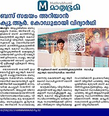
introduced a digital website for the development tourism in Attappadi. The website was created by a Plus Two student
638:
391:
281:
1856:
1502:
1434:
840:
478:
450:
61:
1394:
1371:
1319:
1112:
1127:
1084:
868:
1135:
1072:
There are mainly three Communities of tribes living in Attappadi they are Irulas, Mudugas, and Kurumbas.
689:
area of Attappadi. In February 2021, Attappadi tribal taluk formed by carving out from Mannarkkad taluk.
532:
968:
Kariyur-Vannathorai Prospect: Samples of vein quartz have shown gold contents ranging from 3 to 20 g/t.
1551:
1023:
383:
1798:
645:. Walluvanad was one of the two Taluks included in the Malappuram Revenue Division (the other being
860:
754:
722:
682:
659:
544:
470:
1711:"'പന്ത്രണ്ടാം ക്ലാസുകാരന്റെ ഡിജിറ്റല് അട്ടപ്പാടി ടൂറിസം'; മക്കൾ രാജ പ്രൊഡക്ഷൻസ് ഹിറ്റാകട്ടെ..."
578:
During the last decades of the eighteenth century, the region came under the control of the vast
572:
1292:
666:
of Mannarkkad and Attappadi were separated from Perinthalmanna Taluk to form Mannarkkad Taluk.
1583:
1345:
1126:
The monumental palace-like "Bharat Yatra Centre" at Agali was established in 1984 by a former
892:
872:
615:
579:
564:
446:
286:
1247:
1172:
595:
587:
309:
1339:
1805:
1506:
1438:
1258:
1147:
1131:
1031:
1015:
900:
1786:"ഇനി പരിഹാസം വേണ്ട... അട്ടപ്പാടിയെ ഡിജിറ്റലാക്കാൻ പന്ത്രണ്ടാം ക്ലാസ്സുകാരൻ, വീഡിയോ കാണാം"
1221:
1194:
1099:
896:
630:
599:
591:
540:
57:
962:
Pothupadi Prospect: A sample of vein quartz traversing amphibolite assayed 4 g/t gold.
493:
1835:
1669:
884:
746:
718:
714:
710:
670:
663:
655:
650:
622:
552:
947:
Primary gold mineralization is associated with quartz veins intruding to AS and PGC.
753:
revenue villages of Mannarghat taluk of the Palghat District and Ernad taluk of the
974:
888:
880:
773:
adjacent to Silent Valley and help long-term sustainability of the protected area.
742:
674:
646:
453:
comprising 249 km of land in the western parts of Attappadi. It is one of the
441:
state covering an area of 735 km (284 sq mi). It was carved out of
1636:
1620:
1652:
1580:
Counsel from the Ancients: A Study of Badaga Proverbs, Prayers, Omens and Curses
915:
781:
761:
697:
611:
583:
536:
426:
1559:. Thiruvananthapuram: Directorate of Census Operations, Kerala. p. 260,261
1152:
982:
864:
750:
738:
726:
603:
568:
528:
442:
803:
789:
234:
221:
1523:
1027:
1019:
978:
919:
777:
734:
634:
379:
374:
366:
1821:
1431:
1402:. Thiruvananthapuram: Directorate of Census Operations, Kerala. p. 3.
1035:
911:
876:
856:
730:
678:
642:
462:
458:
17:
1081:
852:
626:
607:
1499:
1080:
The local governments of Attappadi are the Agali, Pudur, and Sholayur
586:, it was a part of Valluvanad Taluk of Malappuram Revenue Division in
124:
1685:
1063:
1059:
1055:
986:
706:
466:
438:
274:
1496:
NILAMBUR-SILENT VALLEY-COIMBATORE – PERSPECTIVE FOR THE RESERVE
1477:
457:. Attappadi valley in Palakkad district along with the neighbouring
1413:
1760:
1098:
1066:
780:
of Attappadi valley ranges from 750 meters (2,460 ft) to the
696:
556:
425:
262:
1467:
pradeepsz PhD thesis Genesis of gold mineralization in Attappady
594:
was the headquarters of the Old Walluvanad Taluk in the British
474:
413:
1686:"Makkal Raja Productions - Wikisource, the free online library"
658:
was separated from Mannarkkad Block. During the formation of
488:
29:
1116:
701:
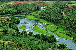
Chemmannur Bridge in Bhavani River, Attappadi, Kerala, India
1671:
The Imperial Gazetteer Of India Vol Ix Bomjur-central India
1735:
1069:
and a section of settlers from Other Districts of Kerala.
535:
dynasty in the medieval period with their headquarters at
1657:. Superintendent Government, Calcutta. 1908. p. 183.
899:
river, originating in the vicinity of Silent Valley. The
571:, held once in 12 years and the endless wars against the
563:, and left for pilgrimage. Valluvanad was famous for the
1283:
1281:
760:
The 249 km Attappadi Reserve Forest is an informal
504:
53:
1641:. Atlantic Publishers & Distri. 1937. p. 100.
1173:"The Kerala Official Language (Legislation) Act, 1969"
1396:
District Census Handbook – Malappuram (Part-C) – 1971
1654:
Imperial gazetteer of India provincial series Madras
64:, and by adding encyclopedic content written from a
477:fields which are also seen in the other regions of
408:
400:
390:
373:
362:
357:
349:
341:
336:
328:
323:
315:
305:
300:
292:
280:
268:
250:
103:
1519:"Proposal for Attappady tribal taluk gathers dust"
1014:Attappady taluk comprises 6 revenue villages like
875:, are located around Silent Valley National Park.
1327:. Chennai: Government of Madras. 1953. p. 1.
1119:, who is the founder of Makkal Raja Productions.
989:are commonly observed in the mineral assemblage.
879:peak, the fifth-highest peak in South India, and
950:Placer deposit along the bank of Siruvani River.
449:in February 2021. Attappadi Reserve Forest is a
455:reserved forests and protected forests of India
1452:Cabinet approves buffer zone for Silent Valley
1449:J The Hindu, Frontpage, retrieved 8 June 2007
1373:District Census Handbook (3) – Palakkad (1961)
1054:The tribal population of the valley is mostly
1494:Asian Nature Conservation Foundation (2006) "
1463:
1461:
729:, on the north by the Nilgiris, south by the
8:
1217:"അട്ടപ്പാടി താലൂക്ക്: ഉദ്യോഗസ്ഥരെ നിയമിച്ചു"
1550:Kerala, Directorate of Census Operations.
1365:
1363:
1361:
839:It is located in the rich biodiversity of
100:
1605:Imperial Gazetteer of India, v. 9, p. 301
1314:
1312:
1310:
84:Learn how and when to remove this message
1862:Tourist attractions in Palakkad district
1388:
1386:
1321:1951 census handbook – Malabar district
1246:" Free India Media, retrieved 4/3/2007
1164:
551:ruler gave a vast extension of land in
547:. According to local legends, the last
407:
389:
372:
356:
335:
332:734.62 km (283.64 sq mi)
322:
299:
249:
214:
142:
130:
121:
116:
1414:"History | Palakkad | India"
1244:Remote adivasis face health care chasm
903:has also its origin in Silent Valley.
621:Walluvanad Taluk was divided into six
598:. Mannarkkad, along with the towns of
45:contains content that is written like
1344:(2007 ed.). Kottayam: DC Books.
614:, was one of the main centres of the
399:
361:
348:
340:
327:
314:
304:
291:
279:
267:
7:
1190:"അട്ടപ്പാടി താലൂക്ക് യാഥാർത്ഥ്യമായി"
1051:were males and 13,919 were females.
1625:. Mittal Publications. p. 183.
705:Attappadi is an extensive mountain
1799:Interdisciplinary Biannual Journal
1553:District Census Handbook, Palakkad
883:are also located in its vicinity.
25:
1379:. Shoranur: Government of Kerala.
190:
157:
1820:
1716:(in Malayalam). 18 February 2022
867:Taluk of Palakkad district, and
721:. It is bordered to the east by
677:(now Karuvarakundu is a part of
492:
437:(HQ:Agali) is a tribal taluk in
255:
189:
182:
156:
149:
132:
123:
34:
1096:under the Govt. sector in 2012.
863:, Attappadi Reserved Forest in
849:New Amarambalam Reserved Forest
669:Later some years, a portion of
1842:Geography of Palakkad district
1527:. 17 June 2015. Archived from
1478:"Agali, attappady – Wikimapia"
1:
1272:"Mineral Resources in Kerala"
845:Karimpuzha Wildlife Sanctuary
1338:Sreedhara Menon, A. (2007).
531:and Attappadi were parts of
1736:"Dhayanidhi Sk - Wikiquote"
1500:PERSPECTIVE FOR THE RESERVE
1498:" retrieved 29 March 2007
1289:"princelystatesofindia.com"
835:Silent Valley National Park
829:Silent Valley National Park
766:Silent Valley National Park
559:to one of their governors,
27:Tehsil in Palakkad district
1878:
1341:A Survey of Kerala History
832:
733:taluk, and on the west by
1847:Reserved forests of India
1426:keralaatbest.com (2002) "
841:Nilgiri Biosphere Reserve
770:Silent Valley Buffer Zone
709:at the headwaters of the
479:Nilgiri Biosphere Reserve
430:Digital Attappadi Project
319:Attappadi Block Panchayat
215:
170:Location in Kerala, India
143:
131:
122:
117:
110:
1622:Gazetteer of South India
138:Attappady Reserve Forest
1578:Hockings, Paul (1988).
1505:2 February 2007 at the
1370:Devassy, M. K. (1965).
1242:Suchitra M.(8/8/2005) "
1113:Makkal Raja Productions
685:was transferred to the
1804:6 October 2014 at the
1765:www.visitattappadi.com
1668:Frowde, Henry (1908).
1430:", retrieved 4/1/2007
1104:
1103:Digital Attappadi News
869:Mukurthi National Park
702:
555:during his journey to
501:This section is empty.
431:
353:87/km (230/sq mi)
98:Taluk in Kerala, India
1829:at Wikimedia Commons
1437:18 April 2007 at the
1393:K. Narayanan (1972).
1257:12 April 2007 at the
1102:
804:11.10889°N 76.55222°E
700:
662:on 16 June 1969, the
473:is known for natural
429:
363: • Official
235:11.08333°N 76.58333°E
66:neutral point of view
1619:Francis, W. (1988).
1608:. DSAL. p. 301.
1108:Development projects
1010:Constituent Villages
533:Valluvanad Swaroopam
392:Vehicle registration
350: • Density
1852:Mountains of Kerala
1250:Remote adivasis..."
1136:Girijan Sevak Samaj
934:Gold Mineralization
861:Malappuram district
799: /
755:Malappuram district
723:Coimbatore district
683:Malappuram district
660:Malappuram district
545:Malappuram district
543:in the present-day
471:Malappuram district
231: /
58:promotional content
1105:
809:11.10889; 76.55222
713:nestled below the
703:
573:Zamorin of Calicut
565:Mamankam festivals
432:
342: • Total
329: • Total
240:11.08333; 76.58333
173:Show map of Kerala
60:and inappropriate
1825:Media related to
1761:"Visit Attappadi"
1690:en.wikisource.org
895:, a tributary of
893:Kunthipuzha River
887:, a tributary of
873:Nilgiris district
616:Malabar Rebellion
580:Kingdom of Mysore
521:
520:
447:Palakkad district
424:
423:
316: • Body
306: • Type
287:Palakkad district
206:Show map of India
203:Attappadi (India)
94:
93:
86:
16:(Redirected from
1869:
1857:Valleys of India
1824:
1809:
1796:
1790:
1789:
1782:
1776:
1775:
1773:
1771:
1757:
1751:
1750:
1748:
1746:
1740:en.wikiquote.org
1732:
1726:
1725:
1723:
1721:
1707:
1701:
1700:
1698:
1696:
1682:
1676:
1675:
1665:
1659:
1658:
1649:
1643:
1642:
1633:
1627:
1626:
1616:
1610:
1609:
1600:
1594:
1593:
1575:
1569:
1568:
1566:
1564:
1558:
1547:
1541:
1540:
1538:
1536:
1515:
1509:
1492:
1486:
1485:
1474:
1468:
1465:
1456:
1447:
1441:
1424:
1418:
1417:
1410:
1404:
1403:
1401:
1390:
1381:
1380:
1378:
1367:
1356:
1355:
1335:
1329:
1328:
1326:
1316:
1305:
1304:
1302:
1300:
1295:on 16 March 2012
1291:. Archived from
1285:
1276:
1275:
1268:
1262:
1240:
1234:
1233:
1231:
1229:
1213:
1207:
1206:
1204:
1202:
1186:
1180:
1179:
1177:
1169:
823:
822:
820:
819:
818:
816:
815:Malleswaran peak
811:
810:
805:
800:
797:
796:
795:
792:
639:Sreekrishnapuram
596:Malabar District
588:Malabar District
561:Valluvakonathiri
549:Cheraman Perumal
516:
513:
503:You can help by
496:
489:
465:region (Eastern
420:
417:
415:
261:
259:
258:
246:
245:
243:
242:
241:
236:
232:
229:
228:
227:
224:
207:
193:
192:
186:
174:
160:
159:
153:
136:
127:
101:
89:
82:
78:
75:
69:
47:an advertisement
38:
37:
30:
21:
1877:
1876:
1872:
1871:
1870:
1868:
1867:
1866:
1832:
1831:
1827:Attappadi taluk
1818:
1813:
1812:
1806:Wayback Machine
1797:
1793:
1784:
1783:
1779:
1769:
1767:
1759:
1758:
1754:
1744:
1742:
1734:
1733:
1729:
1719:
1717:
1714:ETV Bharat News
1709:
1708:
1704:
1694:
1692:
1684:
1683:
1679:
1667:
1666:
1662:
1651:
1650:
1646:
1638:Hyderabad State
1635:
1634:
1630:
1618:
1617:
1613:
1602:
1601:
1597:
1590:
1577:
1576:
1572:
1562:
1560:
1556:
1549:
1548:
1544:
1534:
1532:
1531:on 27 June 2022
1517:
1516:
1512:
1507:Wayback Machine
1493:
1489:
1476:
1475:
1471:
1466:
1459:
1448:
1444:
1439:Wayback Machine
1425:
1421:
1412:
1411:
1407:
1399:
1392:
1391:
1384:
1376:
1369:
1368:
1359:
1352:
1337:
1336:
1332:
1324:
1318:
1317:
1308:
1298:
1296:
1287:
1286:
1279:
1270:
1269:
1265:
1259:Wayback Machine
1241:
1237:
1227:
1225:
1215:
1214:
1210:
1200:
1198:
1188:
1187:
1183:
1175:
1171:
1170:
1166:
1161:
1148:P. R. G. Mathur
1144:
1142:Notable peoples
1132:Chandra Shekhar
1110:
1093:
1078:
1044:
1012:
1004:
995:
936:
909:
901:Kadalundi River
837:
831:
814:
812:
808:
806:
802:
801:
798:
793:
790:
788:
786:
785:
695:
526:
517:
511:
508:
487:
416:.visitattappadi
412:
256:
254:
239:
237:
233:
230:
225:
222:
220:
218:
217:
211:
210:
209:
208:
205:
204:
201:
200:
199:
198:
194:
177:
176:
175:
172:
171:
168:
167:
166:
165:
161:
139:
113:
106:
99:
90:
79:
73:
70:
51:
39:
35:
28:
23:
22:
15:
12:
11:
5:
1875:
1873:
1865:
1864:
1859:
1854:
1849:
1844:
1834:
1833:
1817:
1816:External links
1814:
1811:
1810:
1791:
1777:
1752:
1727:
1702:
1677:
1674:. p. 301.
1660:
1644:
1628:
1611:
1595:
1588:
1570:
1542:
1510:
1487:
1469:
1457:
1442:
1419:
1405:
1382:
1357:
1350:
1330:
1306:
1277:
1263:
1235:
1222:Kerala Kaumudi
1208:
1195:Kerala Kaumudi
1181:
1163:
1162:
1160:
1157:
1156:
1155:
1150:
1143:
1140:
1128:Prime Minister
1109:
1106:
1092:
1089:
1077:
1076:Infrastructure
1074:
1043:
1040:
1011:
1008:
1003:
1002:Administration
1000:
994:
991:
970:
969:
966:
963:
960:
952:
951:
948:
935:
932:
908:
905:
897:Bharathappuzha
855:Rainforest in
833:Main article:
830:
827:
764:bordering the
694:
691:
664:Revenue blocks
651:Revenue blocks
633:, Mannarkkad,
631:Perinthalmanna
623:Revenue blocks
600:Perinthalmanna
592:Perinthalmanna
541:Perinthalmanna
525:
522:
519:
518:
499:
497:
486:
483:
461:valley of the
451:protected area
422:
421:
410:
406:
405:
402:
398:
397:
394:
388:
387:
377:
371:
370:
364:
360:
359:
355:
354:
351:
347:
346:
343:
339:
338:
334:
333:
330:
326:
325:
321:
320:
317:
313:
312:
307:
303:
302:
298:
297:
294:
290:
289:
284:
278:
277:
272:
266:
265:
252:
248:
247:
213:
212:
202:
196:
195:
188:
187:
181:
180:
179:
178:
169:
163:
162:
155:
154:
148:
147:
146:
145:
144:
141:
140:
137:
129:
128:
120:
119:
115:
114:
111:
108:
107:
104:
97:
92:
91:
62:external links
42:
40:
33:
26:
24:
14:
13:
10:
9:
6:
4:
3:
2:
1874:
1863:
1860:
1858:
1855:
1853:
1850:
1848:
1845:
1843:
1840:
1839:
1837:
1830:
1828:
1823:
1815:
1807:
1803:
1800:
1795:
1792:
1787:
1781:
1778:
1766:
1762:
1756:
1753:
1741:
1737:
1731:
1728:
1715:
1712:
1706:
1703:
1691:
1687:
1681:
1678:
1673:
1672:
1664:
1661:
1656:
1655:
1648:
1645:
1640:
1639:
1632:
1629:
1624:
1623:
1615:
1612:
1607:
1606:
1599:
1596:
1591:
1589:9783110113747
1585:
1581:
1574:
1571:
1555:
1554:
1546:
1543:
1530:
1526:
1525:
1520:
1514:
1511:
1508:
1504:
1501:
1497:
1491:
1488:
1483:
1482:wikimapia.org
1479:
1473:
1470:
1464:
1462:
1458:
1454:
1453:
1446:
1443:
1440:
1436:
1433:
1429:
1423:
1420:
1415:
1409:
1406:
1398:
1397:
1389:
1387:
1383:
1375:
1374:
1366:
1364:
1362:
1358:
1353:
1351:9788126415786
1347:
1343:
1342:
1334:
1331:
1323:
1322:
1315:
1313:
1311:
1307:
1294:
1290:
1284:
1282:
1278:
1273:
1267:
1264:
1261:
1260:
1256:
1252:
1251:
1245:
1239:
1236:
1224:
1223:
1218:
1212:
1209:
1197:
1196:
1191:
1185:
1182:
1174:
1168:
1165:
1158:
1154:
1151:
1149:
1146:
1145:
1141:
1139:
1137:
1133:
1129:
1124:
1120:
1118:
1117:Dhayanidhi Sk
1114:
1107:
1101:
1097:
1090:
1088:
1086:
1083:
1075:
1073:
1070:
1068:
1067:tribal people
1065:
1061:
1057:
1052:
1048:
1041:
1039:
1037:
1033:
1029:
1025:
1021:
1017:
1009:
1007:
1001:
999:
992:
990:
988:
984:
980:
976:
967:
964:
961:
958:
957:
956:
949:
946:
945:
944:
941:
933:
931:
927:
923:
921:
917:
913:
906:
904:
902:
898:
894:
890:
886:
885:Bhavani River
882:
878:
874:
870:
866:
862:
858:
854:
850:
846:
842:
836:
828:
826:
821:
783:
779:
774:
771:
767:
763:
758:
756:
752:
748:
744:
740:
736:
732:
728:
724:
720:
719:Western Ghats
716:
715:Nilgiri Hills
712:
711:Bhavani River
708:
699:
692:
690:
688:
687:Silent Valley
684:
680:
676:
672:
671:Karuvarakundu
667:
665:
661:
657:
656:Revenue block
652:
648:
644:
640:
636:
632:
628:
624:
619:
617:
613:
609:
605:
601:
597:
593:
589:
585:
581:
576:
574:
570:
566:
562:
558:
554:
553:South Malabar
550:
546:
542:
538:
534:
530:
523:
515:
506:
502:
498:
495:
491:
490:
484:
482:
480:
476:
472:
468:
464:
460:
456:
452:
448:
444:
440:
436:
428:
419:
411:
403:
395:
393:
385:
381:
378:
376:
368:
365:
352:
344:
331:
318:
311:
308:
296:Dhayanidhi SK
295:
288:
285:
283:
276:
273:
271:
264:
253:
244:
216:Coordinates:
185:
152:
135:
126:
109:
102:
96:
88:
85:
77:
67:
63:
59:
55:
49:
48:
43:This article
41:
32:
31:
19:
1819:
1794:
1780:
1768:. Retrieved
1764:
1755:
1743:. Retrieved
1739:
1730:
1718:. Retrieved
1713:
1705:
1693:. Retrieved
1689:
1680:
1670:
1663:
1653:
1647:
1637:
1631:
1621:
1614:
1604:
1598:
1579:
1573:
1561:. Retrieved
1552:
1545:
1533:. Retrieved
1529:the original
1522:
1513:
1495:
1490:
1481:
1472:
1451:
1445:
1427:
1422:
1408:
1395:
1372:
1340:
1333:
1320:
1297:. Retrieved
1293:the original
1266:
1253:
1249:
1243:
1238:
1226:. Retrieved
1220:
1211:
1199:. Retrieved
1193:
1184:
1167:
1125:
1121:
1111:
1094:
1079:
1071:
1053:
1049:
1045:
1042:Demographics
1013:
1005:
996:
975:Chalcopyrite
971:
953:
939:
937:
928:
924:
910:
889:Kaveri River
881:Anginda peak
838:
775:
759:
743:Pottassery-I
704:
675:Eranad Taluk
668:
647:Eranad Taluk
620:
577:
560:
527:
509:
505:adding to it
500:
434:
433:
401:Nearest city
95:
80:
71:
56:by removing
52:Please help
44:
1720:17 February
1455:6 June 2007
1228:28 February
1201:18 February
916:charnockite
807: /
782:Malleswaran
762:buffer zone
673:village in
612:Tirurangadi
584:British Raj
537:Angadipuram
512:August 2023
469:region) in
238: /
74:August 2020
1836:Categories
1582:. Berlin.
1159:References
1153:Nanjiyamma
1085:Panchayats
1024:Kottathara
983:chalcocite
865:Mannarkkad
853:Nedumkayam
813: (
751:Mannarghat
727:Tamil Nadu
681:Taluk) of
604:Malappuram
569:Tirunavaya
529:Mannarkkad
443:Mannarkkad
337:Population
301:Government
293:Founded by
54:improve it
1524:The Hindu
1091:Education
1028:Padavayal
1020:Kallamala
979:covellite
920:pegmatite
859:Taluk of
794:76°33′8″E
791:11°6′32″N
784:peak at
778:elevation
735:Karimba-I
693:Geography
635:Ottapalam
618:of 1921.
485:Etymology
445:taluk in
435:Attappadi
375:Time zone
369:, English
367:Malayalam
358:Languages
226:76°35′0″E
197:Attappadi
164:Attappadi
118:Attappadi
105:Attappadi
18:Attappady
1808:PDF file
1802:Archived
1745:18 March
1695:18 March
1503:Archived
1435:Archived
1255:Archived
1036:Sholayur
912:Gneisses
877:Mukurthi
857:Nilambur
731:Palakkad
679:Nilambur
643:Pattambi
582:. Under
463:Nilambur
459:Chaliyar
404:Palakkad
380:UTC+5:30
282:District
223:11°5′0″N
1563:27 June
1535:27 June
1299:19 July
1064:Kurumba
1047:girls.
993:Climate
907:Geology
717:of the
627:Mankada
608:Manjeri
524:History
409:Website
251:Country
1770:25 May
1586:
1432:Palgat
1428:Palgat
1348:
1056:Muduga
987:galena
985:, and
891:, and
851:, and
749:, and
707:valley
641:, and
610:, and
467:Eranad
439:Kerala
345:64,083
275:Kerala
260:
1557:(PDF)
1400:(PDF)
1377:(PDF)
1325:(PDF)
1176:(PDF)
1082:Grama
1060:Irula
1032:Pudur
1016:Agali
938:Mani
557:Mecca
539:near
396:KL-50
310:Taluk
270:State
263:India
112:Taluk
1772:2024
1747:2024
1722:2024
1697:2024
1584:ISBN
1565:2022
1537:2022
1346:ISBN
1301:2016
1230:2021
1203:2021
1034:and
940:1965
776:The
745:and
737:and
475:Gold
418:.com
324:Area
871:of
725:in
567:at
507:.
414:www
384:IST
1838::
1763:.
1738:.
1688:.
1521:.
1480:.
1460:^
1385:^
1360:^
1309:^
1280:^
1219:.
1192:.
1130:,
1087:.
1062:,
1058:,
1038:.
1030:,
1026:,
1022:,
1018:,
981:,
977:,
847:,
843:.
757:.
747:II
741:,
739:II
637:,
629:,
625::
606:,
602:,
590:.
575:.
481:.
1788:.
1774:.
1749:.
1724:.
1699:.
1592:.
1567:.
1539:.
1484:.
1416:.
1354:.
1303:.
1274:.
1248:"
1232:.
1205:.
1178:.
817:)
514:)
510:(
386:)
382:(
87:)
81:(
76:)
72:(
68:.
50:.
20:)
Text is available under the Creative Commons Attribution-ShareAlike License. Additional terms may apply.