296:
308:
180:
282:
270:
258:
246:
27:
229:
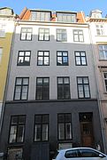
The southeast side of the street consists of just two properties. Boldhusgade 1/Admiralgade 28 is from 1798-1799 and was built by Frantz
Phillip Lange (1756-1805) and Lauritz Thrane (1757-1809). The high cellar and ground floor are dressed while the upper floors stand in exposed, red brick.
225:
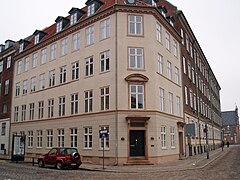
The north west side of the street (even numbers) consists of four properties. Studenterforeningen was for a while based at No. 2 in the first half of the 19th century. It was later home to a theatre, Boldhus
Teatret.
206:
but the old one is still mentioned in the middle of the century and it is therefore unclear when it was demolished. Boldhusgade was created in 1624. The street was completely destroyed in the
219:
195:
constructed a so-called ball house on the south side of the street in 1597. It was used for ball play and other recreational activities.
202:. Skipperboderne, a development of naval barracks, was built close to the ball house in circa 1614. A new ball house was then built on
91:
218:
All the buildings in the street were built in the years just after the
Copenhagen Fire of 1795 and have all been listed on the
379:
295:
307:
56:
184:
207:
192:
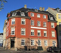
234:, with nine bays towards Boldhusgade, was built for the goldsmith Christian Nielsen Lindbach in 1796–1797.
79:
281:
148:
179:
334:
269:
257:
245:
313:
287:
231:
373:
160:
126:
203:
164:
136:
199:
152:
45:
106:
93:
363:
168:
26:
61:
156:
49:
178:
151:"Ball House Street) is a short, cobbled street in the Old Town of
191:
The street was original called
Adelstredet. The 20-year-old king
132:
122:
85:
75:
67:
55:
41:
33:
220:Danish registry of protected buildings and places
8:
167:in the northeast from where it continues as
19:
18:
326:
241:
7:
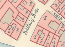
183:Boldhusgade seen on a detail from
14:
306:
294:
280:
268:
256:
244:
25:
1:
16:Street in Copenhagen, Denmark
396:
198:The area was then part of
187:of the East Quarter, 1757.
24:
214:Buildings and residents
208:Copenhagen Fire of 1795
107:55.677306°N 12.581833°E
37:53 m (174 ft)
301:No. 1 (Admiralgade 28)
188:
380:Streets in Copenhagen
366:at indenforvoldene.dk
339:hovedstadshistorie.dk
182:
76:Nearest metro station
163:in the southwest to
112:55.677306; 12.581833
103: /
21:
189:
133:Northeast end
123:Southwest end
142:
141:
387:
351:
350:
348:
346:
331:
310:
298:
284:
272:
260:
248:
118:
117:
115:
114:
113:
108:
104:
101:
100:
99:
96:
29:
22:
395:
394:
390:
389:
388:
386:
385:
384:
370:
369:
360:
355:
354:
344:
342:
333:
332:
328:
323:
316:
311:
302:
299:
290:
285:
276:
273:
264:
261:
252:
249:
240:
216:
177:
159:. It runs from
111:
109:
105:
102:
97:
94:
92:
90:
89:
17:
12:
11:
5:
393:
391:
383:
382:
372:
371:
368:
367:
359:
358:External links
356:
353:
352:
325:
324:
322:
319:
318:
317:
314:Ved Stranden 8
312:
305:
303:
300:
293:
291:
288:Sundorph House
286:
279:
277:
274:
267:
265:
262:
255:
253:
250:
243:
239:
236:
232:Ved Stranden 8
215:
212:
176:
173:
140:
139:
134:
130:
129:
124:
120:
119:
87:
83:
82:
77:
73:
72:
69:
65:
64:
59:
53:
52:
43:
39:
38:
35:
31:
30:
15:
13:
10:
9:
6:
4:
3:
2:
392:
381:
378:
377:
375:
365:
362:
361:
357:
340:
336:
335:"Boldhusgade"
330:
327:
320:
315:
309:
304:
297:
292:
289:
283:
278:
271:
266:
259:
254:
247:
242:
237:
235:
233:
227:
223:
221:
213:
211:
209:
205:
201:
196:
194:
186:
181:
174:
172:
170:
166:
162:
158:
154:
150:
146:
138:
135:
131:
128:
125:
121:
116:
88:
84:
81:
80:Gammel Strand
78:
74:
70:
66:
63:
60:
58:
54:
51:
47:
44:
40:
36:
32:
28:
23:
343:. Retrieved
338:
329:
228:
224:
217:
197:
193:Christian IV
190:
161:Ved Stranden
144:
143:
127:Ved Stranden
98:12°34′54.6″E
95:55°40′38.3″N
364:Boldhusgade
345:20 November
341:(in Danish)
204:Slotsholmen
185:Gedde's mao
165:Admiralgade
145:Boldhusgade
137:Admiralgade
110: /
86:Coordinates
68:Postal code
20:Boldhusgade
321:References
200:Bremerholm
153:Copenhagen
46:Copenhagen
169:Laksegade
374:Category
62:Indre By
42:Location
238:Gallery
175:History
157:Denmark
57:Quarter
50:Denmark
34:Length
275:No. 6
263:No. 4
251:No. 2
347:2018
149:lit.
71:1062
376::
337:.
222:.
210:.
171:.
155:,
48:,
349:.
147:(
Text is available under the Creative Commons Attribution-ShareAlike License. Additional terms may apply.