56:
40:
63:
481:
298:
In the early
Islamic period, the port of Burullus was situated near the mouth of the lake (the place where it was connected to the sea through a small opening). Burullus port functioned as one of the defensive frontier settlements of the Nile Delta coast. An island settlement within the lake called
338:
The lake is separated from the sea by a strip of land approximately 5.5 km (3.4 mi) wide. It is connected to the
Mediterranean by the Burullus outlet, a channel about 250 m (820 ft) wide and 5 m (16 ft) deep. There are approximately 50 islands in the lake with a total
398:
According to a
Biodiversity Report of the Egyptian Environmental Affairs Agency 33 species of fish, 23 species of reptiles, 112 species of birds, and 18 species of mammals live in and around the lake. Fish species declined from 52 recorded at the beginning of the 20th century, mostly due to the
382:
322:
373:. Agriculture drainage water accounts for 97% of the total inflow to the lake (3.9 billion m per year), followed by rain water (2%) and groundwater (1%). 16% of the lake's water evaporates and 84% flows to the sea.
299:
Nastaru lent its name to the lake as a whole. Canals connected the lake to the
Rosetta branch of the Nile. At this time the lake was growing and expanding southwards as a result of changes in
386:
390:
388:
384:
383:
389:
325:
329:
328:
324:
323:
387:
330:
611:
88:
327:
491:
385:
365:
The lake receives drainage waters from surrounding agricultural land and fresh water from the
Brembal Canal. It is considered to be a lake and
604:
792:
326:
55:
536:
436:
552:
782:
620:
597:
797:
701:
576:
486:
584:
696:
736:
746:
691:
686:
279:
646:
731:
681:
751:
661:
726:
787:
636:
756:
628:
507:
207:
641:
229:
761:
303:
802:
676:
585:
Ministry of
Environment Egyptian Environmental Affairs Agency - Natural Protectorates Description
532:
457:
432:
370:
287:
161:
570:
339:
area of 0.7 km (0.27 sq mi). The lake's north shore is formed primarily of
254:
198:
242:
218:
776:
741:
262:
39:
526:
426:
721:
716:
706:
671:
353:
711:
651:
340:
310:
246:
103:
90:
399:
inflow of agricultural drainage into the lake resulting in lower salinity.
589:
366:
348:
17:
344:
307:
300:
283:
656:
234:
528:
The
Medieval Nile: Route, Navigation, and Landscape in Islamic Egypt
569:
452:
380:
320:
250:
593:
510:[The names of some Egyptian countries in Coptic -21].
555:, Chapter on Biodiversity, 2008, accessed on November 8, 2009
265:
222:
531:. The American University in Cairo Press. pp. 72–73.
369:
212:
627:
176:
168:
159:
155:
147:
139:
131:
123:
119:
80:
32:
425:Finkl, Charles W.; Makowski, Christopher (2017).
290:in the north and agricultural land to the south.
495:. Vol. 2. London: John Murray. p. 946.
420:
418:
416:
414:
412:
81:
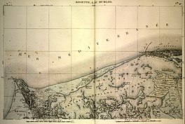
44:Map of Lake Burullus from the early 19th century
605:
8:
428:Coastal Wetlands: Alteration and Remediation
612:
598:
590:
553:Egypt State of the Environment Report 2007
29:
27:Lake in Kafr el-Sheikh Governorate, Egypt
508:"21- أسماء بعض البلاد المصرية بالقبطية"
492:Dictionary of Greek and Roman Geography
408:
551:Egyptian Environmental Affairs Agency:
253:, the name coming from Burullus town (
175:
167:
158:
62:
7:
202:
351:. The dominant lake vegetation is
25:
479:
61:
54:
38:
146:
138:
135:6–21 km (3.7–13.0 mi)
130:
122:
577:New International Encyclopedia
151:75–100 cm (30–39 in)
143:46,200 ha (114,000 acres)
1:
334:Small island on Lake Burullus
489:, ed. (1857). "Sebennytus".
347:, while the south is mainly
235:
213:
819:
793:Kafr El Sheikh Governorate
747:White Desert National Park
394:Fishermen on Lake Burullus
280:Kafr el-Sheikh Governorate
266:
258:
223:
127:c. 54 km (34 mi)
460:Sites Information Service
431:. Springer. p. 418.
188:
184:
49:
37:
752:Gilf Kebir National Park
783:National parks of Egypt
727:Wadi Degla Protectorate
621:National Parks of Egypt
453:"Bahía de Samborombón"
395:
335:
798:Ramsar sites in Egypt
525:Cooper, John (2014).
393:
333:
278:). It is located in
214:Buḥayrat al-Burullus
100: /
396:
336:
286:, bordered by the
177:Reference no.
770:
769:
702:Saluga and Ghazal
391:
371:Ramsar Convention
331:
288:Mediterranean Sea
237:limnē Sebennytikē
232:
224:λίμνη Σεβεννυτική
211:
192:
191:
104:31.483°N 30.867°E
16:(Redirected from
810:
687:Petrified Forest
614:
607:
600:
591:
581:
573:
556:
549:
543:
542:
522:
516:
515:
503:
497:
496:
483:
482:
477:
471:
470:
468:
466:
449:
443:
442:
422:
392:
332:
306:and generalized
269:
268:
260:
240:
228:
226:
225:
216:
206:
204:
172:9 September 1988
115:
114:
112:
111:
110:
105:
101:
98:
97:
96:
93:
83:
65:
64:
58:
42:
30:
21:
818:
817:
813:
812:
811:
809:
808:
807:
773:
772:
771:
766:
652:El Hassana Dome
647:Ashtum El Gamil
623:
618:
568:
565:
560:
559:
550:
546:
539:
524:
523:
519:
506:Pauline Todry.
505:
504:
500:
485:
480:
478:
474:
464:
462:
451:
450:
446:
439:
424:
423:
410:
405:
381:
379:
363:
321:
319:
296:
164:
108:
106:
102:
99:
94:
91:
89:
87:
86:
76:
75:
74:
73:
72:
71:
70:
66:
45:
28:
23:
22:
15:
12:
11:
5:
816:
814:
806:
805:
800:
795:
790:
788:Lakes of Egypt
785:
775:
774:
768:
767:
765:
764:
759:
754:
749:
744:
739:
734:
732:Wadi El Assuti
729:
724:
719:
714:
709:
704:
699:
694:
689:
684:
679:
674:
669:
664:
659:
654:
649:
644:
639:
633:
631:
625:
624:
619:
617:
616:
609:
602:
594:
588:
587:
582:
571:"Burlos"
564:
563:External links
561:
558:
557:
544:
537:
517:
498:
487:Smith, William
472:
444:
437:
407:
406:
404:
401:
378:
375:
362:
359:
318:
315:
295:
292:
274:" or ⲛⲓⲕⲉϫⲱⲟⲩ
272:coast, seaside
243:brackish water
190:
189:
186:
185:
182:
181:
178:
174:
173:
170:
166:
165:
162:Ramsar Wetland
160:
157:
156:
153:
152:
149:
145:
144:
141:
137:
136:
133:
129:
128:
125:
121:
120:
117:
116:
109:31.483; 30.867
84:
78:
77:
68:
67:
60:
59:
53:
52:
51:
50:
47:
46:
43:
35:
34:
26:
24:
14:
13:
10:
9:
6:
4:
3:
2:
815:
804:
801:
799:
796:
794:
791:
789:
786:
784:
781:
780:
778:
763:
760:
758:
755:
753:
750:
748:
745:
743:
742:Wadi El Rayan
740:
738:
737:Wadi El Gamal
735:
733:
730:
728:
725:
723:
720:
718:
715:
713:
710:
708:
705:
703:
700:
698:
697:St. Catherine
695:
693:
690:
688:
685:
683:
680:
678:
675:
673:
670:
668:
667:Lake Burullus
665:
663:
660:
658:
655:
653:
650:
648:
645:
643:
640:
638:
635:
634:
632:
630:
629:Protectorates
626:
622:
615:
610:
608:
603:
601:
596:
595:
592:
586:
583:
579:
578:
572:
567:
566:
562:
554:
548:
545:
540:
538:9789774166143
534:
530:
529:
521:
518:
513:
509:
502:
499:
494:
493:
488:
476:
473:
461:
459:
454:
448:
445:
440:
438:9783319561790
434:
430:
429:
421:
419:
417:
415:
413:
409:
402:
400:
376:
374:
372:
368:
360:
358:
356:
355:
350:
346:
342:
316:
314:
312:
309:
305:
302:
293:
291:
289:
285:
281:
277:
273:
264:
263:Ancient Greek
256:
252:
248:
244:
239:
238:
231:
220:
215:
209:
200:
196:
195:Lake Burullus
187:
183:
179:
171:
163:
154:
150:
148:Average depth
142:
134:
126:
118:
113:
85:
79:
69:Lake Burullus
57:
48:
41:
36:
33:Lake Burullus
31:
19:
762:Black Desert
692:Ras Muhammad
682:Nile Islands
666:
575:
547:
527:
520:
514:(in Arabic).
512:St-Takla.org
511:
501:
490:
475:
463:. Retrieved
456:
447:
427:
397:
364:
352:
341:salt marshes
337:
297:
275:
271:
245:lake in the
236:
203:بحيرة البرلس
194:
193:
140:Surface area
722:Wadi Allaqi
707:Sannur Cave
354:Potamogeton
124:Max. length
107: /
82:Coordinates
803:Nile Delta
777:Categories
712:Siwa Oasis
672:Lake Qarun
662:Gabal Elba
403:References
311:subsidence
304:deposition
247:Nile Delta
169:Designated
132:Max. width
657:El Omayed
637:Abu Galum
361:Hydrology
349:reed beds
317:Geography
308:substrate
230:translit.
208:romanized
465:25 April
377:Wildlife
367:wetlands
345:mudflats
282:east of
267:παράλιος
259:Ϯⲡⲁⲣⲁⲗⲓⲁ
18:Burullus
757:Zaranik
580:. 1905.
301:fluvial
294:History
284:Rosetta
276:Nikejow
261:, from
241:) is a
210::
95:30°52′E
92:31°29′N
642:Ahrash
535:
484:
458:Ramsar
435:
255:Coptic
233:
199:Arabic
677:Nabaq
251:Egypt
219:Greek
717:Taba
533:ISBN
467:2018
433:ISBN
343:and
270:, "
249:in
180:408
779::
574:.
455:.
411:^
357:.
313:.
257::
227:,
221::
217:;
205:,
201::
613:e
606:t
599:v
541:.
469:.
441:.
197:(
20:)
Text is available under the Creative Commons Attribution-ShareAlike License. Additional terms may apply.