68:
44:
75:
181:
376:
A church was built in
Claonaig in 1756. The current Parish Church, built in the late-18th or early-19th century, may incorporate some of its fabric. Its western gable has a bell-cot. It has been converted to a house.
237:
221:
245:
205:
373:
can be reached in 28 mi (45 km) via the B842 coast road or via the B8001 and the A83 which runs down the west coast of
Kintyre (36 mi or 58 km).
517:
361:
and the location of the slipway for the seasonal ferry for Arran. The ferry terminal has a small car park and bus shelter for the bus service to
193:
278:
263:
198:
165:
131:
67:
115:
556:
268:
210:
327:
315:
145:
99:
28:
369:. From Claonaig, Tarbert is 10 mi (16 km) away via the minor B8001 road and the A83. To the south,
43:
410:
344:
53:
495:
362:
170:
186:
88:
550:
415:
340:
49:
370:
348:
449:
532:
519:
293:
280:
427:
366:
336:
155:
358:
137:
332:
472:
389:
365:. The nearest sizeable villages are Tarbert, Skipness and
357:
Claonaig is a hamlet 1 mile (2 kilometres) south of
236:
220:
204:
192:
180:
164:
154:
144:
130:
114:
98:
23:
8:
20:
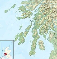
335:peninsula in western Scotland, linked to
379:
441:
331:) is a hamlet on the east coast of the
219:
175:
153:
129:
40:
326:
235:
203:
191:
179:
163:
143:
113:
97:
7:
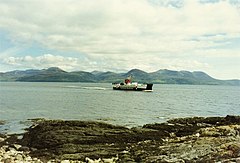
56:ferry from the slipway at Claonaig
14:
497:Claonaig, Skipness Parish Church
74:
73:
66:
42:
1:
18:Human settlement in Scotland
573:
426:
409:
401:
254:
216:
176:
61:
41:
238:Scottish Parliament
354:in the summer months.
328:[ˈkʰl̪ˠɯːnɛkʲ]
319:
166:Postcode district
32:
116:Lieutenancy area
533:55.75575°N 5.39605°W
411:Caledonian MacBrayne
146:Sovereign state
557:Villages in Kintyre
529: /
290: /
538:55.75575; -5.39605
397:Following station
383:Preceding station
294:55.7572°N 5.3932°W
222:UK Parliament
433:
432:
421:
309:
308:
100:Council area
564:
544:
543:
541:
540:
539:
534:
530:
527:
526:
525:
522:
509:
508:
507:
505:
492:
486:
485:
484:
482:
469:
463:
462:
461:
459:
446:
414:
380:
330:
325:
305:
304:
302:
301:
300:
299:55.7572; -5.3932
295:
291:
288:
287:
286:
283:
260:
140:
87:Location within
77:
76:
70:
46:
21:
572:
571:
567:
566:
565:
563:
562:
561:
547:
546:
537:
535:
531:
528:
523:
520:
518:
516:
515:
513:
512:
503:
501:
494:
493:
489:
480:
478:
471:
470:
466:
457:
455:
448:
447:
443:
438:
419:
413:
323:
316:Scottish Gaelic
298:
296:
292:
289:
284:
281:
279:
277:
276:
275:
258:
250:
246:Argyll and Bute
232:
229:Argyll and Bute
136:
126:
123:Argyll and Bute
110:
107:Argyll and Bute
94:
93:
92:
91:
89:Argyll and Bute
85:
84:
83:
82:
78:
57:
37:
29:Scottish Gaelic
19:
12:
11:
5:
570:
568:
560:
559:
549:
548:
511:
510:
487:
477:, ports.org.uk
464:
440:
439:
437:
434:
431:
430:
425:
422:
408:
405:
399:
398:
395:
392:
387:
384:
307:
306:
274:
273:
271:
266:
261:
259:List of places
255:
252:
251:
249:
248:
242:
240:
234:
233:
231:
230:
226:
224:
218:
217:
214:
213:
208:
202:
201:
196:
190:
189:
184:
178:
177:
174:
173:
168:
162:
161:
158:
152:
151:
150:United Kingdom
148:
142:
141:
134:
128:
127:
125:
124:
120:
118:
112:
111:
109:
108:
104:
102:
96:
95:
86:
80:
79:
72:
71:
65:
64:
63:
62:
59:
58:
47:
39:
38:
36:
35:
25:
17:
13:
10:
9:
6:
4:
3:
2:
569:
558:
555:
554:
552:
545:
542:
499:
498:
491:
488:
476:
475:
468:
465:
453:
452:
445:
442:
435:
429:
423:
420:(Summer only)
417:
412:
406:
404:
400:
396:
393:
391:
388:
385:
382:
381:
378:
374:
372:
368:
364:
360:
355:
353:
352:
346:
342:
341:Isle of Arran
338:
334:
329:
321:
317:
313:
303:
272:
270:
267:
265:
262:
257:
256:
253:
247:
244:
243:
241:
239:
228:
227:
225:
223:
215:
212:
209:
207:
200:
197:
195:
188:
185:
183:
172:
169:
167:
159:
157:
149:
147:
139:
135:
133:
122:
121:
119:
117:
106:
105:
103:
101:
90:
69:
60:
55:
51:
50:Isle of Arran
45:
34:
30:
27:
26:
22:
16:
514:
502:, retrieved
496:
490:
479:, retrieved
473:
467:
456:, retrieved
454:, Argyll.org
450:
444:
402:
375:
356:
350:
311:
310:
15:
536: /
504:22 February
481:20 February
371:Campbeltown
297: /
521:55°45′21″N
436:References
324:pronounced
282:55°45′26″N
524:5°23′46″W
500:, Canmore
428:Lochranza
367:Carradale
337:Lochranza
285:5°23′36″W
206:Ambulance
156:Post town
551:Category
474:Claonaig
451:Claonaig
403:Terminus
359:Skipness
351:Catriona
349:MV
320:Claonaig
312:Claonaig
269:Scotland
211:Scottish
199:Scottish
187:Scotland
138:Scotland
81:Claonaig
52:and the
33:Claonaig
24:Claonaig
424:
407:
394:
386:
363:Tarbert
343:by the
339:on the
333:Kintyre
160:TARBERT
132:Country
458:4 June
347:ferry
345:CalMac
182:Police
54:CalMac
418:Ferry
416:Arran
390:Ferry
506:2017
483:2017
460:2014
194:Fire
171:PA29
48:The
553::
322:,
318::
264:UK
31::
314:(
Text is available under the Creative Commons Attribution-ShareAlike License. Additional terms may apply.