49:
215:
312:
61:
330:
Aside from those formed by volcanic eruptions, coulees are commonly canyons characterized by steep walls that have been shaped by erosion. These types of coulees are generally found in the northwestern
347:
caused catastrophic flooding which removed bedrock by massive down-cutting erosion, forming deep canyons. Some coulees may be seasonally dry or contain small streams, however these small
287:
it is applied to valleys. These valleys tend to have high, steep walls. "Hollow" is used as a synonym, often for the smallest of such valleys. The term is also applied to the greater
577:
362:
slopes. These are formed when chunks of the canyon wall give way in a rockslide. Left alone, the valleys are often woodland, with the ridgetops transitioning into
533:
570:
808:
1176:
468:
563:
503:
1802:
460:
1333:
183:
but becoming sizable during rainy weather. As stream channels were dredged or canalized, the term was increasingly applied to
1797:
369:
Coulees provide shelter from wind and concentrated water supplies to plants which would otherwise struggle to survive in the
131:) is a term applied rather loosely to different landforms, all of which refer to a kind of valley or drainage zone. The word
1499:
1449:
1343:
219:
1777:
549:
Easterbrook, Don J. (1999). Surface
Processes and Landforms. Prentice Hall, Upper Saddle River New Jersey. Pp. 381-385
194:
In the northwestern United States, coulee is defined as a large, steep-walled, trench-like trough, which also include
1828:
1823:
1003:
1787:
1739:
1622:
426:
1772:
1489:
1454:
1296:
247:
1782:
1474:
1239:
431:
354:
In
Wisconsin, they are the product of nearly a half million years of erosion, unmodified by glaciation (see
35:
519:
1724:
1582:
1133:
1018:
254:, where pre-flood tributaries enter the coulees at least 100 m (330 ft) above the coulee floor.
1562:
1409:
1371:
820:
759:
395: – Landscape in eastern Washington state scoured by cataclysmic floods during the Pleistocene epoch
1792:
1514:
1338:
1098:
905:
699:
288:
1688:
1683:
1484:
1328:
950:
803:
724:
631:
392:
280:
In the western United States, tongue-like protrusions of solidified lava, forming a sort of canyon.
231:
1714:
1627:
1592:
1444:
960:
865:
769:
661:
594:
235:
223:
1434:
1693:
1532:
1524:
1464:
1424:
1313:
1128:
890:
880:
666:
499:
464:
363:
454:
439:
1607:
1509:
1414:
1013:
1008:
925:
754:
626:
373:
184:
108:
82:
48:
1612:
1572:
1567:
1358:
1171:
1058:
1053:
837:
774:
744:
709:
704:
671:
636:
607:
274:
262:
143:
136:
53:
1673:
1557:
1537:
1419:
1404:
1291:
1276:
1271:
1231:
1211:
1123:
965:
955:
945:
910:
842:
827:
734:
656:
616:
496:
Channeled
Scablands: A Megaflood Landscape, in Geomorphological Landscapes of the World
355:
251:
1817:
1754:
1749:
1734:
1719:
1668:
1663:
1429:
1394:
1348:
1308:
1303:
1063:
935:
895:
641:
621:
348:
332:
266:
199:
520:"The Coulee Region - La Crosse, WI - Wisconsin Historical Markers on Waymarking.com"
214:
1744:
1494:
1479:
1469:
1318:
1249:
1118:
1083:
998:
940:
815:
714:
676:
651:
398:
316:
299:
295:
243:
239:
153:
420:
1653:
1577:
1281:
1244:
1191:
915:
900:
875:
749:
1759:
1439:
1323:
1263:
1221:
1093:
930:
798:
739:
729:
646:
555:
351:
do not have the magnitude of force necessary to form such expansive erosion.
320:
1729:
1678:
1648:
1617:
1547:
1459:
1216:
1103:
1088:
1028:
975:
970:
870:
793:
783:
681:
311:
284:
168:
31:
30:
This article is about the valley-related landform. For lava dome flows, see
453:
Edwards, Jay
Dearborn; Nicolas Kariouk Pecquet du Bellay de Verton (2004).
1399:
1366:
1043:
885:
852:
377:
195:
60:
1709:
1658:
1186:
1181:
1163:
1143:
1048:
985:
920:
857:
380:
344:
340:
324:
258:
65:
17:
1504:
1376:
1201:
1196:
1148:
1138:
1108:
1033:
788:
691:
590:
336:
270:
203:
180:
161:
42:
1602:
1587:
1542:
1286:
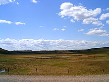
1259:
1206:
1073:
1068:
1038:
1023:
832:
602:
586:
370:
359:
310:
213:
191:. The term is also used for small ditches or canals in the swamp.
188:
59:
47:
52:
This side canyon of Grand Coulee in
Washington was carved by the
1632:
1597:
1153:
1113:
1078:
540:, September 1976 (James R. Batt, (ed.)), Retrieved July 26, 2007
358:). The loose rocks at the base of the wall form what are called
157:
559:
1552:
993:
123:
117:
91:
230:
The dry, braided channels formed by glacial drainage of the
298:
may have been a contributing factor to the flooding of the
97:
401: – Ancient river bed in the U.S. state of Washington
383:
along streams in coulees and at the base of their walls.
68:, with steep but lower sides, and water in the bottom.
114:
88:
366:
when not turned into pasture or used for row crops.
179:) originally meant a gully or ravine usually dry or
120:
94:
1702:
1641:
1523:
1385:
1357:
1258:
1230:
1162:
984:
851:
768:
690:
601:
111:
85:
419:
456:A Creole lexicon: architecture, landscape, people
261:channeling rain runoff in the area east of the
152:The term is often used interchangeably in the
571:
534:"Coulees and the coulee country of Wisconsin"
291:metropolitan area (i.e. the "Coulee Region").
8:
578:
564:
556:
494:Baker, Victor (2010). Migon, Piotr (ed.).
339:. In the American west, rapid melting of
1177:International scale of river difficulty
489:
487:
411:
156:for any number of water features, from
7:
440:participating institution membership
315:A view upward into a coulee in the
25:
461:Louisiana State University Press
107:
81:
1334:Flooded grasslands and savannas
27:Type of valley or drainage zone
1:
1500:Universal Soil Loss Equation
1450:Hydrological transport model
1344:Storm Water Management Model
498:. Springer. pp. 21–28.
376:. Trees are often found in
250:, lower Grand Coulee, have
218:Drumheller Channels in the
64:A view through a coulee in
1845:
1004:Antecedent drainage stream
40:
29:
1768:
1740:River valley civilization
1623:Riparian-zone restoration
427:Oxford English Dictionary
187:, generally smaller than
1803:Countries without rivers
1778:Rivers by discharge rate
1490:Runoff model (reservoir)
1455:Infiltration (hydrology)
538:Wisconsin Academy Review
41:Not to be confused with
1475:River Continuum Concept
1240:Agricultural wastewater
432:Oxford University Press
343:at the end of the last
36:Coulee (disambiguation)
1798:River name etymologies
1725:Hydraulic civilization
1583:Floodplain restoration
1359:Point source pollution
1134:Sedimentary structures
327:
294:The Gassman Coulee in
226:
69:
57:
34:. For other uses, see
1410:Discharge (hydrology)
1372:Industrial wastewater
853:Sedimentary processes
314:
217:
63:
51:
1515:Volumetric flow rate
1099:Riffle-pool sequence
289:La Crosse, Wisconsin
1689:Whitewater kayaking
1684:Whitewater canoeing
1485:Runoff curve number
1329:Flood pulse concept
430:(Online ed.).
393:Channeled Scablands
273:at the base of the
246:. Moses Coulee and
1715:Aquatic toxicology
1628:Stream restoration
1593:Infiltration basin
1445:Hydrological model
961:Sediment transport
784:Estavelle/Inversac
662:Subterranean river
328:
227:
210:Types and examples
70:
58:
1829:Erosion landforms
1824:Fluvial landforms
1811:
1810:
1788:Whitewater rivers
1694:Whitewater slalom
1525:River engineering
1425:Groundwater model
1386:River measurement
1314:Flood forecasting
1129:Sedimentary basin
986:Fluvial landforms
891:Bed material load
667:River bifurcation
470:978-0-8071-2764-3
438:(Subscription or
364:tallgrass prairie
335:and southwestern
202:incised into the
185:perennial streams
16:(Redirected from
1836:
1773:Rivers by length
1608:River morphology
1510:Wetted perimeter
1415:Drainage density
926:Headward erosion
755:Perennial stream
627:Blackwater river
580:
573:
566:
557:
550:
547:
541:
530:
524:
523:
516:
510:
509:
491:
482:
481:
479:
477:
450:
444:
443:
435:
423:
416:
374:sagebrush steppe
130:
129:
126:
125:
122:
119:
116:
113:
104:
103:
100:
99:
96:
93:
90:
87:
21:
1844:
1843:
1839:
1838:
1837:
1835:
1834:
1833:
1814:
1813:
1812:
1807:
1783:Drainage basins
1764:
1698:
1637:
1613:Retention basin
1573:Erosion control
1568:Detention basin
1519:
1435:Hjulström curve
1387:
1381:
1353:
1297:Non-water flood
1254:
1226:
1172:Helicoidal flow
1158:
1059:Fluvial terrace
1054:Floating island
980:
855:
847:
838:Rhythmic spring
772:
764:
745:Stream gradient
686:
672:River ecosystem
637:Channel pattern
605:
597:
584:
554:
553:
548:
544:
532:Cotton Mather,
531:
527:
518:
517:
513:
506:
493:
492:
485:
475:
473:
471:
452:
451:
447:
437:
418:
417:
413:
408:
389:
309:
275:Rocky Mountains
265:in the western
263:Missouri Coteau
252:hanging valleys
212:
137:Canadian French
135:comes from the
110:
106:
84:
80:
54:Missoula floods
46:
39:
28:
23:
22:
15:
12:
11:
5:
1842:
1840:
1832:
1831:
1826:
1816:
1815:
1809:
1808:
1806:
1805:
1800:
1795:
1790:
1785:
1780:
1775:
1769:
1766:
1765:
1763:
1762:
1757:
1752:
1747:
1742:
1737:
1732:
1727:
1722:
1717:
1712:
1706:
1704:
1700:
1699:
1697:
1696:
1691:
1686:
1681:
1676:
1674:Stone skipping
1671:
1666:
1661:
1656:
1651:
1645:
1643:
1639:
1638:
1636:
1635:
1630:
1625:
1620:
1615:
1610:
1605:
1600:
1595:
1590:
1585:
1580:
1575:
1570:
1565:
1560:
1558:Drop structure
1555:
1550:
1545:
1540:
1538:Balancing lake
1535:
1529:
1527:
1521:
1520:
1518:
1517:
1512:
1507:
1502:
1497:
1492:
1487:
1482:
1477:
1472:
1467:
1465:Playfair's law
1462:
1457:
1452:
1447:
1442:
1437:
1432:
1427:
1422:
1420:Exner equation
1417:
1412:
1407:
1405:Bradshaw model
1402:
1397:
1391:
1389:
1383:
1382:
1380:
1379:
1374:
1369:
1363:
1361:
1355:
1354:
1352:
1351:
1346:
1341:
1336:
1331:
1326:
1321:
1316:
1311:
1306:
1301:
1300:
1299:
1294:
1292:Urban flooding
1284:
1279:
1277:Crevasse splay
1274:
1272:100-year flood
1268:
1266:
1256:
1255:
1253:
1252:
1247:
1242:
1236:
1234:
1232:Surface runoff
1228:
1227:
1225:
1224:
1219:
1214:
1212:Stream capture
1209:
1204:
1199:
1194:
1189:
1184:
1179:
1174:
1168:
1166:
1160:
1159:
1157:
1156:
1151:
1146:
1141:
1136:
1131:
1126:
1124:Rock-cut basin
1121:
1116:
1111:
1106:
1101:
1096:
1091:
1086:
1081:
1076:
1071:
1066:
1061:
1056:
1051:
1046:
1041:
1036:
1031:
1026:
1021:
1016:
1011:
1006:
1001:
996:
990:
988:
982:
981:
979:
978:
973:
968:
966:Suspended load
963:
958:
956:Secondary flow
953:
948:
946:Retrogradation
943:
938:
933:
928:
923:
918:
913:
911:Dissolved load
908:
903:
898:
893:
888:
883:
878:
873:
868:
862:
860:
849:
848:
846:
845:
843:Spring horizon
840:
835:
830:
828:Mineral spring
825:
824:
823:
813:
812:
811:
809:list in the US
806:
796:
791:
786:
780:
778:
766:
765:
763:
762:
757:
752:
747:
742:
737:
735:Stream channel
732:
727:
722:
717:
712:
707:
702:
696:
694:
688:
687:
685:
684:
679:
674:
669:
664:
659:
657:Drainage basin
654:
649:
644:
639:
634:
629:
624:
619:
617:Alluvial river
613:
611:
599:
598:
585:
583:
582:
575:
568:
560:
552:
551:
542:
525:
511:
504:
483:
469:
463:. p. 73.
445:
410:
409:
407:
404:
403:
402:
396:
388:
385:
356:Driftless Area
349:misfit streams
308:
305:
304:
303:
292:
281:
278:
255:
220:Columbia Basin
211:
208:
200:flood channels
175:(also spelled
26:
24:
14:
13:
10:
9:
6:
4:
3:
2:
1841:
1830:
1827:
1825:
1822:
1821:
1819:
1804:
1801:
1799:
1796:
1794:
1791:
1789:
1786:
1784:
1781:
1779:
1776:
1774:
1771:
1770:
1767:
1761:
1758:
1756:
1755:Surface water
1753:
1751:
1750:Sacred waters
1748:
1746:
1743:
1741:
1738:
1736:
1735:Riparian zone
1733:
1731:
1728:
1726:
1723:
1721:
1720:Body of water
1718:
1716:
1713:
1711:
1708:
1707:
1705:
1701:
1695:
1692:
1690:
1687:
1685:
1682:
1680:
1677:
1675:
1672:
1670:
1669:Riverboarding
1667:
1665:
1664:River surfing
1662:
1660:
1657:
1655:
1652:
1650:
1647:
1646:
1644:
1640:
1634:
1631:
1629:
1626:
1624:
1621:
1619:
1616:
1614:
1611:
1609:
1606:
1604:
1601:
1599:
1596:
1594:
1591:
1589:
1586:
1584:
1581:
1579:
1576:
1574:
1571:
1569:
1566:
1564:
1561:
1559:
1556:
1554:
1551:
1549:
1546:
1544:
1541:
1539:
1536:
1534:
1531:
1530:
1528:
1526:
1522:
1516:
1513:
1511:
1508:
1506:
1503:
1501:
1498:
1496:
1493:
1491:
1488:
1486:
1483:
1481:
1478:
1476:
1473:
1471:
1468:
1466:
1463:
1461:
1458:
1456:
1453:
1451:
1448:
1446:
1443:
1441:
1438:
1436:
1433:
1431:
1428:
1426:
1423:
1421:
1418:
1416:
1413:
1411:
1408:
1406:
1403:
1401:
1398:
1396:
1393:
1392:
1390:
1388:and modelling
1384:
1378:
1375:
1373:
1370:
1368:
1365:
1364:
1362:
1360:
1356:
1350:
1349:Return period
1347:
1345:
1342:
1340:
1337:
1335:
1332:
1330:
1327:
1325:
1322:
1320:
1317:
1315:
1312:
1310:
1309:Flood control
1307:
1305:
1304:Flood barrier
1302:
1298:
1295:
1293:
1290:
1289:
1288:
1285:
1283:
1280:
1278:
1275:
1273:
1270:
1269:
1267:
1265:
1261:
1257:
1251:
1248:
1246:
1243:
1241:
1238:
1237:
1235:
1233:
1229:
1223:
1220:
1218:
1215:
1213:
1210:
1208:
1205:
1203:
1200:
1198:
1195:
1193:
1190:
1188:
1185:
1183:
1180:
1178:
1175:
1173:
1170:
1169:
1167:
1165:
1161:
1155:
1152:
1150:
1147:
1145:
1142:
1140:
1137:
1135:
1132:
1130:
1127:
1125:
1122:
1120:
1117:
1115:
1112:
1110:
1107:
1105:
1102:
1100:
1097:
1095:
1092:
1090:
1087:
1085:
1082:
1080:
1077:
1075:
1072:
1070:
1067:
1065:
1062:
1060:
1057:
1055:
1052:
1050:
1047:
1045:
1042:
1040:
1037:
1035:
1032:
1030:
1027:
1025:
1022:
1020:
1017:
1015:
1012:
1010:
1007:
1005:
1002:
1000:
997:
995:
992:
991:
989:
987:
983:
977:
974:
972:
969:
967:
964:
962:
959:
957:
954:
952:
949:
947:
944:
942:
939:
937:
936:Palaeochannel
934:
932:
929:
927:
924:
922:
919:
917:
914:
912:
909:
907:
904:
902:
899:
897:
896:Granular flow
894:
892:
889:
887:
884:
882:
879:
877:
874:
872:
869:
867:
864:
863:
861:
859:
854:
850:
844:
841:
839:
836:
834:
831:
829:
826:
822:
819:
818:
817:
814:
810:
807:
805:
802:
801:
800:
797:
795:
792:
790:
787:
785:
782:
781:
779:
776:
771:
767:
761:
758:
756:
753:
751:
748:
746:
743:
741:
738:
736:
733:
731:
728:
726:
723:
721:
718:
716:
713:
711:
708:
706:
703:
701:
698:
697:
695:
693:
689:
683:
680:
678:
675:
673:
670:
668:
665:
663:
660:
658:
655:
653:
650:
648:
645:
643:
642:Channel types
640:
638:
635:
633:
630:
628:
625:
623:
622:Braided river
620:
618:
615:
614:
612:
609:
604:
600:
596:
592:
588:
581:
576:
574:
569:
567:
562:
561:
558:
546:
543:
539:
536:, pp. 22-25,
535:
529:
526:
521:
515:
512:
507:
505:9789048130542
501:
497:
490:
488:
484:
472:
466:
462:
458:
457:
449:
446:
441:
433:
429:
428:
422:
415:
412:
405:
400:
397:
394:
391:
390:
386:
384:
382:
379:
375:
372:
367:
365:
361:
357:
352:
350:
346:
342:
338:
334:
333:United States
326:
322:
318:
313:
307:Geomorphology
306:
302:in June 2011.
301:
297:
293:
290:
286:
282:
279:
276:
272:
268:
267:United States
264:
260:
257:The furrowed
256:
253:
249:
248:Lenore Canyon
245:
241:
237:
233:
229:
228:
225:
221:
216:
209:
207:
205:
201:
197:
192:
190:
186:
182:
178:
174:
170:
165:
163:
159:
155:
150:
148:
145:
141:
138:
134:
128:
102:
78:
74:
67:
62:
55:
50:
44:
37:
33:
19:
1793:Flash floods
1745:River cruise
1642:River sports
1495:Stream gauge
1480:Rouse number
1470:Relief ratio
1319:Flood-meadow
1250:Urban runoff
1164:Fluvial flow
1149:River valley
1119:River island
1084:Meander scar
999:Alluvial fan
941:Progradation
816:Karst spring
760:Winterbourne
719:
715:Chalk stream
677:River source
652:Distributary
545:
537:
528:
514:
495:
474:. Retrieved
455:
448:
425:
414:
399:Grand Coulee
368:
353:
329:
317:Oldman River
300:Souris River
296:North Dakota
269:and western
244:Moses Coulee
240:Grand Coulee
193:
181:intermittent
176:
172:
167:In southern
166:
154:Great Plains
151:
146:
139:
132:
76:
72:
71:
32:Lava coulées
1654:Fly fishing
1578:Fish ladder
1563:Daylighting
1282:Flash flood
1245:First flush
1192:Plunge pool
916:Downcutting
901:Debris flow
876:Aggradation
750:Stream pool
234:of eastern
149:'to flow'.
1818:Categories
1760:Wild river
1440:Hydrograph
1430:Hack's law
1395:Baer's law
1339:Inundation
1324:Floodplain
1264:stormwater
1222:Whitewater
1094:Oxbow lake
931:Knickpoint
906:Deposition
799:Hot spring
740:Streamflow
730:Stream bed
647:Confluence
442:required.)
406:References
321:Lethbridge
319:valley in
238:, such as
236:Washington
224:Washington
1730:Limnology
1679:Triathlon
1649:Canyoning
1618:Revetment
1548:Check dam
1460:Main stem
1217:Waterfall
1104:Point bar
1089:Mouth bar
1029:Billabong
976:Water gap
971:Wash load
951:Saltation
871:Anabranch
794:Holy well
682:Tributary
285:Wisconsin
232:Scablands
206:plateau.
196:spillways
171:the word
169:Louisiana
1533:Aqueduct
1400:Baseflow
1367:Effluent
1044:Cut bank
1009:Avulsion
886:Bed load
866:Abrasion
421:"coulee"
387:See also
381:habitats
378:riparian
341:glaciers
259:moraines
1710:Aquifer
1703:Related
1659:Rafting
1187:Meander
1182:Log jam
1144:Thalweg
1049:Estuary
921:Erosion
858:erosion
770:Springs
725:Current
692:Streams
632:Channel
595:springs
591:streams
476:15 July
345:ice age
325:Alberta
142:, from
66:Alberta
18:Coulees
1505:WAFLEX
1377:Sewage
1260:Floods
1202:Riffle
1197:Rapids
1139:Strath
1109:Ravine
1034:Canyon
789:Geyser
720:Coulee
705:Bourne
700:Arroyo
603:Rivers
587:Rivers
502:
467:
337:Canada
271:Canada
204:basalt
189:bayous
177:coolie
173:coulée
162:creeks
147:couler
144:French
140:coulée
133:coulee
77:coulée
73:Coulee
43:Coolie
1603:Levee
1588:Flume
1543:Canal
1287:Flood
1207:Shoal
1074:Gully
1069:Gulch
1039:Chine
1024:Bayou
881:Armor
833:Ponor
608:lists
436:
371:xeric
360:scree
158:ponds
75:, or
1633:Weir
1598:Leat
1262:and
1154:Wadi
1114:Rill
1079:Glen
1064:Gill
1014:Bank
856:and
821:list
804:list
775:list
710:Burn
593:and
500:ISBN
478:2011
465:ISBN
242:and
198:and
1553:Dam
1019:Bar
994:Ait
283:In
222:of
160:to
105:or
1820::
589:,
486:^
459:.
424:.
323:,
164:.
124:iː
118:uː
98:eɪ
92:uː
777:)
773:(
610:)
606:(
579:e
572:t
565:v
522:.
508:.
480:.
434:.
277:.
127:/
121:l
115:k
112:ˈ
109:/
101:/
95:l
89:k
86:ˈ
83:/
79:(
56:.
45:.
38:.
20:)
Text is available under the Creative Commons Attribution-ShareAlike License. Additional terms may apply.