29:
540:
278:
267:
41:
428:). When the dam was built 1963–1966, a nice lake for holidays and watersports was created. A few kilometers further on, the Innerste leaves the Harz Mountains near the town of
562:
572:
518:
468:
145:
402:, one of the first tributaries, flows into the Innerste in the middle of Wildemann. The Innerste turns to the North to
577:
582:
567:
407:
359:. As a small brook, the Innerste flows west and passes a system of lakes, the first of which is called
28:
414:
flows into the
Innerste in the middle of Lautenthal. The name of the town means "Laute Valley". Near
352:
399:
483:
459:(12 km (7.5 mi) in length). Some more towns on its course are the southern quarters of
456:
476:
424:
271:
444:
406:(300 m), another town on its course and flows parallel to the abandoned track of the
277:
231:
543:
Umweltkartendienst des
Niedersächsischen Ministeriums für Umwelt, Energie und Klimaschutz
556:
502:
486:. About 18 km (11 mi) further on, it flows into the Leine near the town of
433:
252:
66:
429:
116:
472:
464:
460:
415:
403:
387:
332:
282:
160:
147:
395:
239:
487:
266:
491:
256:
56:
432:(204 m) and turns to the Northwest. The first tributary is river
330:. It may be the name referred to in the name of the battlefield of
40:
452:
448:
411:
276:
265:
260:
235:
227:
131:
348:
95:
451:(21 km (13 mi) in length), river Bruchgraben, river
419:
355:
to the southwest at an elevation of 615 m and is called
443:, a hilly countryside. Further tributaries are river
322:(1013), probably goes back to the Indo-Germanic root
398:(390 m), one of the smallest towns in Germany.
351:
mountains, 4 km (2.5 mi) from the town of
386:Having passed through the middle of the village of
223:
218:
204:
196:
184:
176:
137:
125:
115:
101:
89:
81:
72:
62:
52:
47:
21:
294:The river name is not related to the German word
263:river and 101 km (63 mi) in length.
482:North of Hildesheim, the Innerste enters the
8:
541:Environmental map service of Lower Saxony (
447:(42 km (26 mi) in length), river
536:
534:
439:From here, the Innerste flows through the
39:
530:
436:(12 km (7.5 mi) in length).
18:
7:
210:±10 m/s (350 cu ft/s)
188:1,265 km (488 sq mi)
14:
259:. It is a right tributary of the
494:, at an elevation of 65 m.
281:River Innerste in the center of
27:
519:List of rivers of Lower Saxony
302:, in earlier times called the
139: • coordinates
1:
347:The river's source is in the
180:100.7 km (62.6 mi)
73:Physical characteristics
103: • elevation
127: • location
91: • location
599:
479:in the North of the City.
206: • average
107:615 m (2,018 ft)
394:and turns to the west to
365:Oberer Nassenwieser Teich
214:
192:
111:
77:
38:
26:
563:Tributaries of the Leine
33:The Innerste in Sarstedt
505:wrote a novelle titled
408:Innerste Valley Railway
573:Rivers of Lower Saxony
467:. The Innerste passes
390:, the Innerste passes
286:
274:
363:. The next lakes are
280:
269:
353:Clausthal-Zellerfeld
270:River Innerste near
161:52.24722°N 9.82500°E
298:meaning innermost.
219:Basin features
157: /
578:Rivers of the Harz
484:North German Plain
379:. The German word
373:Ziegenberger Teich
369:Bärenbrucher Teich
290:Origin of the name
287:
275:
583:Rivers of Germany
477:Steuerwald Castle
469:Marienburg Castle
425:Innerstetalsperre
328:turbulent, strong
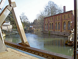
272:Steuerwald Castle
245:
244:
166:52.24722; 9.82500
590:
547:
538:
475:(90 m) and
471:, the centre of
418:the Innerste is
207:
172:
171:
169:
168:
167:
162:
158:
155:
154:
153:
150:
104:
92:
43:
31:
19:
16:River in Germany
598:
597:
593:
592:
591:
589:
588:
587:
553:
552:
551:
550:
539:
532:
527:
515:
500:
345:
292:
205:
165:
163:
159:
156:
151:
148:
146:
144:
143:
140:
128:
102:
90:
34:
17:
12:
11:
5:
596:
594:
586:
585:
580:
575:
570:
568:Innerste basin
565:
555:
554:
549:
548:
529:
528:
526:
523:
522:
521:
514:
511:
499:
496:
383:means "pond".
357:Innerstesprung
344:
341:
291:
288:
251:is a river in
243:
242:
225:
221:
220:
216:
215:
212:
211:
208:
202:
201:
198:
194:
193:
190:
189:
186:
182:
181:
178:
174:
173:
141:
138:
135:
134:
129:
126:
123:
122:
119:
113:
112:
109:
108:
105:
99:
98:
93:
87:
86:
83:
79:
78:
75:
74:
70:
69:
64:
60:
59:
54:
50:
49:
45:
44:
36:
35:
32:
24:
23:
15:
13:
10:
9:
6:
4:
3:
2:
595:
584:
581:
579:
576:
574:
571:
569:
566:
564:
561:
560:
558:
546:
544:
537:
535:
531:
524:
520:
517:
516:
512:
510:
508:
504:
503:Wilhelm Raabe
497:
495:
493:
489:
485:
480:
478:
474:
470:
466:
462:
458:
454:
450:
446:
442:
437:
435:
431:
427:
426:
421:
417:
413:
409:
405:
401:
397:
393:
389:
384:
382:
378:
374:
370:
366:
362:
358:
354:
350:
342:
340:
338:
337:
335:
329:
325:
321:
317:
313:
309:
305:
301:
297:
289:
284:
279:
273:
268:
264:
262:
258:
254:
250:
241:
237:
233:
229:
226:
222:
217:
213:
209:
203:
199:
195:
191:
187:
183:
179:
175:
170:
142:
136:
133:
130:
124:
120:
118:
114:
110:
106:
100:
97:
94:
88:
84:
80:
76:
71:
68:
65:
61:
58:
55:
51:
46:
42:
37:
30:
25:
20:
542:
507:Die Innerste
506:
501:
481:
440:
438:
423:
392:Prinzenteich
391:
385:
380:
376:
372:
368:
364:
360:
356:
346:
333:
331:
327:
323:
319:
315:
311:
307:
303:
299:
295:
293:
253:Lower Saxony
248:
246:
67:Lower Saxony
490:, south of
441:Harzvorland
430:Langelsheim
410:. Here the
339:(16 A.D.).
318:(1065) and
224:Progression
164: /
557:Categories
525:References
473:Hildesheim
465:Hildesheim
461:Salzgitter
455:and river
416:Lautenthal
404:Lautenthal
388:Buntenbock
377:Sumpfteich
361:Entensumpf
283:Hildesheim
185:Basin size
149:52°14′50″N
396:Wildemann
312:Indistria
285:in winter
240:North Sea
197:Discharge
152:9°49′30″E
513:See also
488:Sarstedt
400:Grumbach
320:Indrista
316:Entrista
314:(1313),
310:(1567),
308:Inderste
306:(1805),
300:Innerste
296:innerste
249:Innerste
48:Location
22:Innerste
492:Hanover
457:Beuster
257:Germany
57:Germany
53:Country
420:dammed
375:, and
343:Course
334:Idista
200:
177:Length
121:
85:
82:Source
498:Media
453:Neile
449:Lamme
445:Nette
434:Grane
422:(the
412:Laute
381:Teich
304:Inste
261:Leine
236:Weser
232:Aller
228:Leine
132:Leine
117:Mouth
63:State
463:and
349:Harz
336:viso
247:The
96:Harz
324:oid
559::
533:^
509:.
371:,
367:,
326:=
255:,
238:→
234:→
230:→
545:)
Text is available under the Creative Commons Attribution-ShareAlike License. Additional terms may apply.