91:
697:
246:
Agriculture is the main industry of Kŭmch'ŏn. Mainly rice but also several other products like beans, wheat, ginseng and tobacco are cultivated. Kŭmch'ŏn, like many other parts of northern Korea, is a resource-rich region. Some resources are for example asbestos, molybdenum, mercury, cinnabar,
217:
Kŭmch'ŏn had a fairly severe climate, with an average temperature of 10.2 degrees. Inland, the average
January temperature is -7 degrees, while the average August temperature is 25.6 degrees. The county receives an average of 1,100 mm of rain per year.
46:
590:
591:"United Nations Statistics Division; Preliminary results of the 2008 Census of Population of the Democratic People's Republic of Korea conducted on 1–15 October 2008"
830:
90:
663:
728:
568:
123:
597:
869:
705:
656:
621:
563:
111:
672:
649:
116:
209:). According to preliminary results from the 2008 population census, it has a population of 3,255,388.
231:
786:
190:
186:
781:
761:
736:
435:
422:
235:
771:
756:
741:
206:
158:
863:
816:
811:
796:
776:
766:
746:
194:
801:
227:
182:
806:
791:
696:
162:
104:
845:
832:
641:
202:
198:
718:
713:
686:
178:
174:
17:
549:
546:
543:
530:
527:
524:
511:
508:
505:
492:
489:
486:
473:
470:
467:
454:
451:
448:
409:
406:
403:
390:
387:
384:
371:
368:
365:
352:
349:
346:
333:
330:
327:
314:
311:
308:
295:
292:
289:
271:
625:
276:
645:
238:. There is also a highway which runs through Kŭmch'ŏn-ŭp.
95:
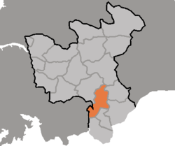
Map of North
Hwanghae showing the location of Kumchon
727:
704:
679:
144:
139:
122:
110:
100:
77:
66:
58:
53:
32:
27:County in North Hwanghae Province, North Korea
657:
8:
585:
583:
664:
650:
642:
193:county. It is bordered to the east by the
29:
265:
579:
569:Administrative divisions of North Korea
138:
121:
99:
87:
76:
52:
255:The county is divided into one town (
143:
109:
65:
57:
7:
173:Kŭmch'ŏn is bordered to the west by
25:
165:. It has a population of 68,216.
695:
89:
1:
226:The county is served by the
54:Korean transcription(s)
886:
870:Counties of North Hwanghae
185:, and to the north by Mt.
693:
88:
44:
564:Geography of North Korea
251:Administrative divisions
124:Administrative divisions
36:
673:North Hwanghae Province
117:North Hwanghae Province
846:38.16111°N 126.47611°E
181:, to the northwest by
622:"중앙일보 - 아시아 첫 인터넷 신문"
234:, which stops in at
232:Korean State Railway
80:Revised Romanization
851:38.16111; 126.47611
842: /
259:) and 14 villages (
157:is a county in the
177:, to the south by
145: • Total
59: • Hanja
825:
824:
555:
554:
152:
151:
69:McCune-Reischauer
16:(Redirected from
877:
857:
856:
854:
853:
852:
847:
843:
840:
839:
838:
835:
699:
666:
659:
652:
643:
637:
636:
634:
633:
624:. Archived from
618:
612:
611:
609:
608:
603:on 25 March 2009
602:
596:. Archived from
595:
587:
266:
247:serpentine etc.
236:Kŭmch'ŏn station
93:
81:
70:
39:
30:
21:
885:
884:
880:
879:
878:
876:
875:
874:
860:
859:
850:
848:
844:
841:
836:
833:
831:
829:
828:
826:
821:
723:
700:
691:
675:
670:
640:
631:
629:
620:
619:
615:
606:
604:
600:
593:
589:
588:
581:
577:
560:
253:
244:
224:
215:
171:
155:Kŭmch'ŏn County
96:
79:
68:
49:
40:
37:
35:
34:Kŭmch'ŏn County
28:
23:
22:
15:
12:
11:
5:
883:
881:
873:
872:
862:
861:
823:
822:
820:
819:
814:
809:
804:
799:
794:
789:
784:
779:
774:
769:
764:
759:
754:
749:
744:
739:
733:
731:
725:
724:
722:
721:
716:
710:
708:
702:
701:
694:
692:
690:
689:
683:
681:
677:
676:
671:
669:
668:
661:
654:
646:
639:
638:
613:
578:
576:
573:
572:
571:
566:
559:
556:
553:
552:
541:
538:
534:
533:
522:
519:
515:
514:
503:
500:
496:
495:
484:
481:
477:
476:
465:
462:
458:
457:
446:
443:
439:
438:
433:
430:
426:
425:
420:
417:
413:
412:
401:
398:
394:
393:
382:
379:
375:
374:
363:
360:
356:
355:
344:
341:
337:
336:
325:
322:
318:
317:
306:
303:
299:
298:
287:
284:
280:
279:
274:
269:
252:
249:
243:
240:
223:
222:Transportation
220:
214:
211:
207:South Hwanghae
170:
167:
159:North Hwanghae
150:
149:
146:
142:
141:
137:
136:
126:
120:
119:
114:
108:
107:
102:
98:
97:
94:
86:
85:
82:
75:
74:
71:
64:
63:
60:
56:
55:
51:
50:
45:
42:
41:
33:
26:
24:
14:
13:
10:
9:
6:
4:
3:
2:
882:
871:
868:
867:
865:
858:
855:
818:
815:
813:
810:
808:
805:
803:
800:
798:
795:
793:
790:
788:
785:
783:
780:
778:
775:
773:
770:
768:
765:
763:
760:
758:
755:
753:
750:
748:
745:
743:
740:
738:
735:
734:
732:
730:
726:
720:
717:
715:
712:
711:
709:
707:
703:
698:
688:
685:
684:
682:
678:
674:
667:
662:
660:
655:
653:
648:
647:
644:
628:on 2011-07-13
627:
623:
617:
614:
599:
592:
586:
584:
580:
574:
570:
567:
565:
562:
561:
557:
551:
548:
545:
542:
539:
536:
535:
532:
529:
526:
523:
520:
517:
516:
513:
510:
507:
504:
501:
498:
497:
494:
491:
488:
485:
482:
479:
478:
475:
472:
469:
466:
463:
460:
459:
456:
453:
450:
447:
444:
441:
440:
437:
434:
431:
428:
427:
424:
421:
418:
415:
414:
411:
408:
405:
402:
399:
396:
395:
392:
389:
386:
383:
380:
377:
376:
373:
370:
367:
364:
361:
358:
357:
354:
351:
348:
345:
342:
339:
338:
335:
332:
329:
326:
323:
320:
319:
316:
313:
310:
307:
304:
301:
300:
297:
294:
291:
288:
285:
282:
281:
278:
275:
273:
270:
268:
267:
264:
262:
258:
250:
248:
241:
239:
237:
233:
229:
228:P'yongbu line
221:
219:
212:
210:
208:
204:
200:
196:
195:Ryesŏng River
192:
188:
184:
180:
176:
168:
166:
164:
160:
156:
147:
135:
131:
127:
125:
118:
115:
113:
106:
103:
92:
84:Geumcheon-gun
83:
78: •
72:
67: •
61:
48:
43:
31:
19:
827:
751:
630:. Retrieved
626:the original
616:
605:. Retrieved
598:the original
461:Ryongsŏng-ri
429:Paek'yang-ri
260:
256:
254:
245:
225:
216:
189:(562 m) and
172:
161:province of
154:
153:
133:
129:
73:Kŭmch'ŏn-gun
849: /
837:126°28′34″E
537:Wŏnmyŏng-ri
442:Ryanghap-ri
378:Munmyŏng-ri
283:Kŭmch'ŏn-ŭp
205:county (in
163:North Korea
105:North Korea
834:38°09′40″N
632:2009-12-10
607:2018-08-21
575:References
480:Singang-ri
416:Paengma-ri
397:Namjŏng-ri
359:Kyejŏng-ri
340:Kangnam-ri
321:Kangbuk-ri
302:Hyŏnnae-ri
272:Chosŏn'gŭl
140:Population
782:Sinp'yŏng
762:P'yŏngsan
499:Tŏksal-li
203:Pongch'ŏn
199:P'yŏngsan
169:Geography
864:Category
752:Kŭmch'ŏn
737:Chunghwa
729:Counties
558:See also
518:Wŏlam-ri
242:Industry
179:Kaep'ung
112:Province
817:Yŏnt'an
777:Sin'gye
772:Sangwŏn
757:Pongsan
742:Hwangju
719:Songrim
714:Sariwŏn
687:Sariwŏn
680:Capital
230:of the
213:Climate
191:Sin'gye
187:Pakbong
175:Kaesŏng
101:Country
18:Kumchon
812:Yŏnsan
802:T'osan
797:Sŭngho
787:Sŏhŭng
767:Rinsan
747:Koksan
706:Cities
277:Hancha
201:, and
183:T'osan
148:68,216
47:County
807:Ŭnp'a
601:(PDF)
594:(PDF)
132:, 14
792:Suan
540:원명리
521:월암리
502:덕산리
483:신강리
464:룡성리
445:량합리
436:白陽里
432:백양리
423:白馬里
419:백마리
400:남정리
381:문명리
362:계정리
343:강남리
324:강북리
305:현내리
286:금천읍
263:).
62:金川郡
38:금천군
866::
582:^
261:ri
257:ŭp
197:,
134:ri
130:ŭp
128:1
665:e
658:t
651:v
635:.
610:.
550:里
547:明
544:圓
531:里
528:岩
525:月
512:里
509:山
506:德
493:里
490:江
487:新
474:里
471:城
468:龍
455:里
452:合
449:兩
410:里
407:亭
404:南
391:里
388:明
385:文
372:里
369:井
366:鷄
353:里
350:南
347:江
334:里
331:北
328:江
315:里
312:內
309:峴
296:邑
293:川
290:金
20:)
Text is available under the Creative Commons Attribution-ShareAlike License. Additional terms may apply.