347:
59:
302:
84:
422:
329:
320:
311:
338:
91:
66:
42:
293:
280:
The World
Waterfall Database declared this waterfall to be one of the "best in the world". In March 2011 CNN/Budget Travel sat Langfossen as one of the worlds ten most beautiful waterfalls. The waterfall is one of the few in Norway that has not been used in hydroelectric power generation, so it is
133:
463:
58:
492:
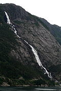
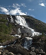
269:. The water falls down a towering mountain, a total distance of about 612 metres (2,008 ft) before the water leaps out into
487:
456:
402:
83:
126:
449:
346:
274:
360:
380:
301:
254:
225:
265:. The waterfall is located about 5 kilometres (3.1 mi) southwest of the village of
433:
270:
482:
476:
421:
328:
319:
148:
135:
250:
170:
165:
310:
429:
266:
258:
115:
337:
17:
292:
41:
262:
119:
277:
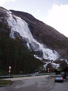
runs along the base of the waterfall, making access very easy.
437:
234:
224:
216:
208:
200:
192:
184:
176:
164:
125:
111:
32:
457:
8:
464:
450:
40:
29:
372:
288:
46:View of the Langfossen waterfall (2006)
7:
418:
416:
240:8 m/s (280 cu ft/s)
90:
65:
25:
420:
361:List of waterfalls § Norway
345:
336:
327:
318:
309:
300:
291:
89:
82:
64:
57:
233:
207:
191:
183:
175:
403:"10 most beautiful waterfalls"
1:
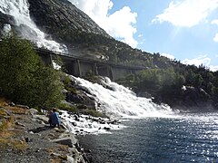
273:at the base of the mountain.
27:Waterfall in Vestland, Norway
436:. You can help Knowledge by
401:Collins, Beth (2011-03-11).
281:still in its natural state.
509:
415:
383:. World Waterfall Database
230:710 metres (2,330 ft)
204:612 metres (2,008 ft)
188:612 metres (2,008 ft)
149:59.8400276°N 6.343217529°E
107:
51:
39:
493:Vestland geography stubs
212:107 metres (351 ft)
180:228 metres (748 ft)
220:76 metres (249 ft)
154:59.8400276; 6.343217529
488:Waterfalls of Vestland
432:location article is a
73:Show map of Vestland
275:European route E134
145: /
98:Show map of Norway
445:
444:
255:Etne Municipality
244:
243:
171:Sliding horsetail
16:(Redirected from
500:
466:
459:
452:
424:
417:
407:
406:
398:
392:
391:
389:
388:
377:
349:
340:
331:
322:
313:
304:
295:
160:
159:
157:
156:
155:
150:
146:
143:
142:
141:
138:
99:
93:
92:
86:
74:
68:
67:
61:
44:
30:
21:
508:
507:
503:
502:
501:
499:
498:
497:
473:
472:
471:
470:
413:
411:
410:
400:
399:
395:
386:
384:
379:
378:
374:
369:
357:
350:
341:
332:
323:
314:
305:
296:
287:
236:
193:Number of drops
153:
151:
147:
144:
139:
136:
134:
132:
131:
103:
102:
101:
100:
97:
96:
95:
94:
77:
76:
75:
72:
71:
70:
69:
47:
34:
28:
23:
22:
15:
12:
11:
5:
506:
504:
496:
495:
490:
485:
475:
474:
469:
468:
461:
454:
446:
443:
442:
425:
409:
408:
393:
371:
370:
368:
365:
364:
363:
356:
353:
352:
351:
344:
342:
335:
333:
326:
324:
317:
315:
308:
306:
299:
297:
290:
286:
283:
242:
241:
238:
232:
231:
228:
222:
221:
218:
214:
213:
210:
206:
205:
202:
198:
197:
194:
190:
189:
186:
182:
181:
178:
174:
173:
168:
162:
161:
129:
123:
122:
113:
109:
108:
105:
104:
88:
87:
81:
80:
79:
78:
63:
62:
56:
55:
54:
53:
52:
49:
48:
45:
37:
36:
26:
24:
14:
13:
10:
9:
6:
4:
3:
2:
505:
494:
491:
489:
486:
484:
481:
480:
478:
467:
462:
460:
455:
453:
448:
447:
441:
439:
435:
431:
426:
423:
419:
414:
404:
397:
394:
382:
376:
373:
366:
362:
359:
358:
354:
348:
343:
339:
334:
330:
325:
321:
316:
312:
307:
303:
298:
294:
289:
284:
282:
278:
276:
272:
268:
264:
260:
256:
252:
248:
239:
229:
227:
223:
219:
217:Average width
215:
211:
203:
199:
195:
187:
179:
172:
169:
167:
163:
158:
130:
128:
124:
121:
117:
114:
110:
106:
85:
60:
50:
43:
38:
31:
19:
438:expanding it
427:
412:
396:
385:. Retrieved
375:
279:
246:
245:
201:Longest drop
185:Total height
271:Åkrafjorden
253:located in
209:Total width
152: /
127:Coordinates
477:Categories
387:2015-04-01
381:"Langfoss"
367:References
247:Langfossen
137:59°50′24″N
33:Langfossen
251:waterfall
237:flow rate
177:Elevation
140:6°20′36″E
430:Vestland
355:See also
261:county,
259:Vestland
116:Vestland
112:Location
35:Langfoss
18:Langfoss
285:Gallery
235:Average
405:. CNN.
263:Norway
120:Norway
428:This
267:Fjæra
249:is a
483:Etne
434:stub
166:Type
257:in
226:Run
479::
118:,
465:e
458:t
451:v
440:.
390:.
196:1
20:)
Text is available under the Creative Commons Attribution-ShareAlike License. Additional terms may apply.