83:
75:
59:
20:
372:
303:
134:. The Lappwald was a border forest for many centuries between the Brunswick and Prussian territories. Numerous smugglers and other criminals, including the well-known figure of "Robber Captain Rose" (
296:
289:
724:
98:
hills, which lie about 10 km further west. The forests of the
Lappwald are almost entirely uninhabited. The only settlements are the Helmstedt hamlet of
252:
729:
34:
is a heavily wooded range of hills, 20 km long and up to 5 km wide, in central
Germany. It stretches northwards from the town of
197:
era created large areas of bog in the
Helmstedt Basin that were transformed under sub-tropical climatic conditions into massive
189:, a period of some 71 million years, the sea washed chalk, marls and sands in several flood phases into the Helmstedt and
146:
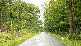
505:
590:
126:
in the year 1147. There is no clear derivation for the name "Lappwald". The most likely theory is to do with the
47:
244:
111:
46:
runs through the woods, of which about three quarters is on Lower Saxon terrain. The
Lappwald is part of the
145:
In the
Lappwald northeast of Helmstedt are the remains of a defensive ditch forming part of the old dyke to
555:
138:, real name: Carl Wallmann) used the forest's border situation to their advantage. In the 20th century the
605:
427:
650:
695:
640:
437:
665:
595:
530:
520:
462:
139:
99:
87:
24:
328:
630:
615:
600:
580:
560:
495:
162:
703:
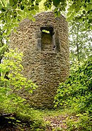
620:
575:
535:
447:
442:
190:
281:
193:
hollow and thus covered the underlying rock. Further flooding by the sea in the succeeding
585:
182:
660:
570:
475:
380:
312:
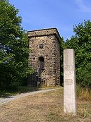
177:
From a geological point of view, the
Lappwald, which reaches a height of 211 m on the
718:
550:
414:
403:
361:
43:
153:
from the 13th century which are referred to as the 1st and 2nd
Walbeck Watchtowers (
82:
685:
525:
510:
452:
336:
320:
39:
490:
432:
346:
239:
95:
74:
58:
19:
398:
393:
316:
198:
186:
150:
63:
267:
254:
480:
388:
166:
35:
655:
371:
670:
635:
625:
565:
540:
485:
470:
194:
158:
675:
645:
610:
500:
351:
341:
127:
142:
divided the
Lappwald, following the old Brunswick-Prussian boundary.
103:
185:
due to the sharply downfaulted terrain it is surrounded by. In the
680:
545:
515:
422:
94:
The
Lappwald runs from north-west to south-east parallel to the
285:
234:
110:
in the south, and the installations of the old airbase of
694:
461:
412:
379:
327:
219:Helmstedt - die Geschichte einer deutschen Stadt
149:. The structures that have survived include two
181:, is a hollow, that only appears like a raised
122:The first records describe the Lappwald as the
161:watchtower is located immediately next to the
297:
8:
304:
290:
282:
81:
73:
57:
18:
210:
725:Forests and woodlands of Lower Saxony
240:Private website about the Nature Park
7:
78:Magdeburg watchtower near Helmstedt
14:
370:
16:Wooded hills in central Germany
1:
169:on the edge of the Lappwald.
730:Hill ranges of Lower Saxony
62:The 1st Walbecker Warte, a
746:
157:). Another well-preserved
23:Road in the Lappwald near
368:
268:52.2559778°N 11.0398056°E
86:Watchtower on the former
235:Official tourism website
48:Elm-Lappwald Nature Park
245:Lappwald Nature Reserve
221:, 2. Aufl. 2004, S. 184
66:on the Helmstedt dyke (
273:52.2559778; 11.0398056
91:
79:
71:
27:
217:Hans-Ehrhard Müller:
85:
77:
61:
38:. The border between
22:
696:East Hesse Highlands
136:Räuberhauptmann Rose
463:Weser-Leine Uplands
264: /
140:Inner German Border
88:Inner German Border
428:Lübbecke Loessland
329:North German Plain
92:
80:
72:
28:
712:
711:
606:Reinhausen Forest
561:Hildesheim Forest
496:Calenberg Uplands
438:Osnabrück Uplands
737:
704:Kaufungen Forest
651:Solling Foreland
621:Salzgitter Hills
576:Innerste Uplands
531:Göttingen Forest
506:Dransfeld Forest
448:Teutoburg Forest
443:Ravensberg Hills
374:
306:
299:
292:
283:
279:
278:
276:
275:
274:
269:
265:
262:
261:
260:
257:
222:
215:
165:federal road to
745:
744:
740:
739:
738:
736:
735:
734:
715:
714:
713:
708:
690:
641:Silkerode Hills
586:Kleiner Deister
457:
408:
375:
366:
323:
310:
272:
270:
266:
263:
258:
255:
253:
251:
250:
231:
226:
225:
216:
212:
207:
175:
155:Walbecker Warte
120:
90:in the Lappwald
56:
17:
12:
11:
5:
743:
741:
733:
732:
727:
717:
716:
710:
709:
707:
706:
700:
698:
692:
691:
689:
688:
683:
678:
673:
668:
663:
658:
653:
648:
643:
638:
633:
628:
623:
618:
613:
608:
603:
598:
593:
588:
583:
578:
573:
571:Homburg Forest
568:
563:
558:
553:
548:
543:
538:
533:
528:
523:
518:
513:
508:
503:
498:
493:
488:
483:
478:
476:Alfeld Uplands
473:
467:
465:
459:
458:
456:
455:
450:
445:
440:
435:
430:
425:
419:
417:
410:
409:
407:
406:
401:
396:
391:
385:
383:
381:Harz Mountains
377:
376:
369:
367:
365:
364:
359:
354:
349:
344:
339:
333:
331:
325:
324:
311:
309:
308:
301:
294:
286:
248:
247:
242:
237:
230:
229:External links
227:
224:
223:
209:
208:
206:
203:
174:
171:
119:
116:
114:in the north.
55:
52:
15:
13:
10:
9:
6:
4:
3:
2:
742:
731:
728:
726:
723:
722:
720:
705:
702:
701:
699:
697:
693:
687:
684:
682:
679:
677:
674:
672:
669:
667:
664:
662:
659:
657:
654:
652:
649:
647:
644:
642:
639:
637:
634:
632:
629:
627:
624:
622:
619:
617:
614:
612:
609:
607:
604:
602:
599:
597:
596:Nörten Forest
594:
592:
589:
587:
584:
582:
579:
577:
574:
572:
569:
567:
564:
562:
559:
557:
554:
552:
549:
547:
544:
542:
539:
537:
534:
532:
529:
527:
524:
522:
521:Ellenser Wald
519:
517:
514:
512:
509:
507:
504:
502:
499:
497:
494:
492:
489:
487:
484:
482:
479:
477:
474:
472:
469:
468:
466:
464:
460:
454:
451:
449:
446:
444:
441:
439:
436:
434:
431:
429:
426:
424:
421:
420:
418:
416:
415:Weser Uplands
411:
405:
404:Harz Foreland
402:
400:
397:
395:
392:
390:
387:
386:
384:
382:
378:
373:
363:
362:Rehburg Hills
360:
358:
355:
353:
350:
348:
345:
343:
340:
338:
335:
334:
332:
330:
326:
322:
318:
314:
307:
302:
300:
295:
293:
288:
287:
284:
280:
277:
259:11°02′23.30″E
256:52°15′21.52″N
246:
243:
241:
238:
236:
233:
232:
228:
220:
214:
211:
204:
202:
200:
196:
192:
191:Schöppenstedt
188:
184:
180:
172:
170:
168:
164:
160:
156:
152:
148:
143:
141:
137:
133:
129:
125:
117:
115:
113:
109:
105:
101:
100:Bad Helmstedt
97:
89:
84:
76:
69:
65:
60:
53:
51:
49:
45:
44:Saxony-Anhalt
41:
37:
33:
26:
25:Bad Helmstedt
21:
661:Thüster Berg
526:Giesen Hills
511:Duinger Berg
453:Wiehen Hills
356:
321:Lower Saxony
249:
218:
213:
178:
176:
154:
144:
135:
131:
123:
121:
107:
93:
67:
40:Lower Saxony
31:
29:
686:Weser Hills
433:Melle Hills
317:hill ranges
271: /
151:watchtowers
719:Categories
399:Upper Harz
394:Lower Harz
205:References
201:deposits.
199:brown coal
187:Cretaceous
132:Einlappens
106:sector of
64:watchtower
616:Rotenberg
601:Osterwald
591:Steinberg
556:Hellberge
491:Bückeberg
481:Amtsberge
389:High Harz
167:Magdeburg
112:Mariental
36:Helmstedt
671:Vorberge
636:Sauberge
631:Sandwald
626:Sackwald
581:Katzberg
566:Holzberg
541:Harplage
536:Hainberg
486:Bramwald
471:Ahlsburg
357:Lappwald
313:Mountain
195:Tertiary
179:Heidberg
159:medieval
124:Lapvualt
108:Autobahn
102:and the
68:Landwehr
54:Location
32:Lappwald
676:Vorholz
646:Solling
611:Reuberg
501:Deister
342:Drawehn
173:Geology
147:Walbeck
128:hunting
118:History
666:Vogler
656:Süntel
413:Lower
104:Harbke
681:Weper
551:Heber
546:Harrl
516:Elfas
183:horst
130:term
423:Gehn
352:Külf
337:Asse
315:and
42:and
30:The
347:Elm
319:of
163:B 1
96:Elm
721::
50:.
305:e
298:t
291:v
70:)
Text is available under the Creative Commons Attribution-ShareAlike License. Additional terms may apply.