29:
261:
250:
405:, incorporating part of the former Talbot Inn, and with 15th-century origins; the 17th-century 74 Low Petergate, built as a house; 74 Low Petergate formerly served as the Petergate frontage to the Old White Swan Inn. In 1552 both properties were in the possession of Robert Hall; the 15th-century 76 Low Petergate; and 17th-century 78 Low Petergate. On the south-west side are
351:; 8 High Petergate, with a 14th-century roof truss; the Hole in the Wall pub, mostly 18th-century but with some earlier timber framing; 12–18 High Petergate, an early-20th century range built in imitation of an earlier building which stood on the site; 24–36 High Petergate, facing the Minster, built in 1838 but incorporating parts of a Georgian building;
240:
The street remained important over the following centuries, and in the 17th century, the Talbot Inn was established, one of the main inns in the city. In the 18th- and 19th-centuries, parts of the street were rebuilt, and buildings around the front of York
Minster were demolished, to open up access
224:
The current property boundaries largely date from the 10th century, and the street has always been a desirable area, with its junction with
Stonegate a particularly high-status location. In the Mediaeval period, the street lay immediately outside the precinct of the minster. As the minster is
409:, built in the 14th century; 49 and 51 Low Petergate, with Mediaeval origins; 55 and 57 Low Petergate, both 17th-century; the 14th-century 67 Low Petergate; and then a timber-framed row, seven of which have their gable ends facing the street: 17th-century 71 Low Petergate, 16th-century
413:, 14th-century 79 Low Petergate, 15th-century 81 Low Petergate, and 83 Low Petergate, built about 1600. 87 Low Petergate has 14th-century origins; 89 Low Petergate is 17th-century; and 91–93 Low Petergate has some 17th-century material.
619:
213:
argues that the street fell out of use immediately after the Roman period, but was re-established while the Roman walls still survived. This may have been as early as 627, when the first
389:
The street numbering continues in Low
Petergate, and on the north-east side lie 48–50 Low Petergate, with some Mediaeval stonework in the basement; the 18th-century
324:
leads off the south-west side, as does the snickelway Lund's Court, while another snickelway, Hornpot Lane, leads off the north-east side. The street ends at
229:, this led to the name "Petergate", which was first recorded in about 1190. In 1283, a wall was constructed around the precinct, with gateways opposite
686:
205:. The main deviation from the Roman route is around its junction with Grape Lane, and this has been associated with destruction occurring when the
233:
and
Stonegate. Buildings on the north-east side of the street were built up against the wall. Almost the whole street lay within the parish of
1089:
348:
544:
292:(also known as Little Peculiar Lane), the shortest official snickelway in the city, leads off its north-east side. At the front of
336:. Until the creation of King's Square, in the 18th century, it was considered to continue slightly further, to a junction with
217:
was built. In its early years, the minster had a large cemetery, which extended as far as
Petergate, around its junction with
603:
347:
On High
Petergate, notable buildings on the north-east side include 4 High Petergate, built in 1782 and possibly designed by
66:
679:
410:
383:
379:
359:. On the south-west side lie 3 High Petergate, mostly early 18th-century but with some earlier timber framing;
1084:
887:
699:
695:
672:
394:
285:
817:
406:
402:
325:
202:
154:
1038:
932:
747:
398:
364:
390:
352:
234:
927:
494:
429:
992:
922:
912:
857:
837:
752:
742:
737:
519:
329:
301:
178:
121:
28:
982:
962:
872:
727:
1079:
206:
260:
1023:
1008:
907:
867:
732:
644:
599:
465:
375:
356:
1058:
967:
822:
591:
360:
313:
218:
210:
131:
897:
892:
832:
382:, built in the 1700s; 31 High Petergate, with 15th-century origins; and the timber-framed
368:
281:
273:
190:
237:, the church, on the street and next to the Minster, having been first recorded in 1294.
249:
1013:
937:
862:
807:
782:
717:
372:
309:
297:
230:
116:
1073:
917:
847:
337:
317:
136:
957:
942:
852:
762:
305:
293:
288:, built around 1840 and today occupied by The Fat Badger inn. The Hole-in-the-Wall
241:
to it. Despite this, numerous
Mediaeval buildings survive, all in commercial use.
214:
126:
34:
545:"The Fat Badger, York: a characterful 4-star inn built into the ancient city wall"
363:, with 16th-century origins; the 16th-century 7 High Petergate; the 17th-century
1043:
947:
797:
757:
341:
333:
269:
254:
226:
198:
1028:
977:
842:
812:
802:
767:
664:
321:
289:
141:
81:
68:
1033:
972:
952:
877:
787:
371:; and the 17th-century 17–19 High Petergate. Beyond Duncombe Place are the
177:. The well-known view of the Minster from Low Petergate is described by the
467:
An
Inventory of the Historical Monuments in City of York, Volume 5, Central
1053:
1048:
987:
882:
792:
777:
772:
194:
280:
terminates, and it runs south-east. Immediately beside the walls is the
1018:
277:
101:
569:
827:
722:
259:
248:
703:
166:
53:
668:
209:
entered York in 866. Based on archaeological records, the
320:, past which the street continues as Low Petergate.
397:, built by John Stockdale in about 1500; the former
201:, to the Porta Principalis Sinistra, in what is now
1001:
710:
264:
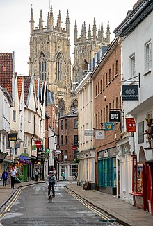
View south on High
Petergate, towards Low Petergate
197:, which ran from the Porta Principalis Dextra, now
150:
107:
97:
60:
49:
521:A History of the County of York: the City of York
570:"Petergate (High and Low), York - Jorvik.co.uk"
189:Petergate generally follows the course of the
680:
8:
620:"Building record MYO1264 – 74 Low Petergate"
296:, it opens up to form a major junction with
253:Looking north along High Petergate, towards
21:
598:. Yale University Press. pp. 220–224.
460:
458:
456:
454:
452:
450:
687:
673:
665:
33:View north-west along Low Petergate, with
27:
20:
430:"Character area 10: The medieval streets"
524:. London: Victoria County History. 1961
489:
487:
485:
421:
7:
596:Yorkshire: York and the East Riding
543:Strick, Katie (29 September 2022).
169:, in England. It is divided into
165:is a street in the city centre of
14:
624:York Historic Environment Record
1:
1090:Odonyms referring to religion
355:church; and the 15th-century
312:. The next junction is with
367:pub; the large 18th-century
411:73, 75 and 77 Low Petergate
1106:
268:High Petergate starts at
42:
26:
407:41 and 43 Low Petergate
403:64 and 66 Low Petergate
245:Layout and architecture
16:Street in York, England
649:British History Online
399:York College for Girls
308:, with access also to
265:
257:
353:St Michael-le-Belfrey
263:
252:
235:St Michael-le-Belfrey
993:Whip-Ma-Whop-Ma-Gate
738:Chapter House Street
645:"Houses – Petergate"
470:. London: HMSO. 1981
434:City of York Council
384:33–35 High Petergate
380:25–29 High Petergate
179:City of York Council
44:Location within York
933:St Sampson's Square
395:56–60 Low Petergate
286:2–2A High Petergate
151:South east end
98:North west end
78: /
23:
928:St Leonard's Place
344:and King's Court.
266:
258:
207:Great Heathen Army
82:53.9614°N 1.0824°W
1067:
1066:
1024:Exhibition Square
1009:Bishopthorpe Road
1002:Outside the walls
923:St Helen's Square
913:Precentor's Court
888:Parliament Street
592:Pevsner, Nikolaus
572:. 30 January 2013
376:23 High Petergate
365:Eagle & Child
357:38 High Petergate
328:, where it meets
302:Precentor's Court
160:
159:
122:Precentor's Court
37:in the background
1097:
689:
682:
675:
666:
660:
659:
657:
655:
641:
635:
634:
632:
630:
616:
610:
609:
588:
582:
581:
579:
577:
566:
560:
559:
557:
555:
549:Evening Standard
540:
534:
533:
531:
529:
516:
510:
509:
507:
505:
499:York Civic Trust
491:
480:
479:
477:
475:
462:
445:
444:
442:
440:
426:
361:5 High Petergate
211:York Civic Trust
181:as "excellent".
93:
92:
90:
89:
88:
87:53.9614; -1.0824
83:
79:
76:
75:
74:
71:
56:, United Kingdom
31:
24:
1105:
1104:
1100:
1099:
1098:
1096:
1095:
1094:
1085:Streets in York
1070:
1069:
1068:
1063:
1039:Lawrence Street
997:
898:Peasholme Green
833:Little Shambles
748:Clifford Street
706:
693:
663:
653:
651:
643:
642:
638:
628:
626:
618:
617:
613:
606:
590:
589:
585:
575:
573:
568:
567:
563:
553:
551:
542:
541:
537:
527:
525:
518:
517:
513:
503:
501:
493:
492:
483:
473:
471:
464:
463:
448:
438:
436:
428:
427:
423:
419:
369:Petergate House
282:grade-II listed
274:York city walls
247:
191:via principalis
187:
146:
109:
86:
84:
80:
77:
72:
69:
67:
65:
64:
45:
38:
17:
12:
11:
5:
1103:
1101:
1093:
1092:
1087:
1082:
1072:
1071:
1065:
1064:
1062:
1061:
1056:
1051:
1046:
1041:
1036:
1031:
1026:
1021:
1016:
1014:Blossom Street
1011:
1005:
1003:
999:
998:
996:
995:
990:
985:
980:
975:
970:
965:
960:
955:
950:
945:
940:
938:St Saviourgate
935:
930:
925:
920:
915:
910:
905:
900:
895:
890:
885:
880:
875:
870:
865:
860:
855:
850:
845:
840:
835:
830:
825:
820:
815:
810:
805:
800:
795:
790:
785:
783:Duncombe Place
780:
775:
770:
765:
760:
755:
750:
745:
740:
735:
730:
725:
720:
714:
712:
708:
707:
694:
692:
691:
684:
677:
669:
662:
661:
636:
611:
604:
583:
561:
535:
511:
481:
446:
420:
418:
415:
373:grade I listed
349:Peter Atkinson
298:Duncombe Place
246:
243:
231:Duncombe Place
186:
183:
171:High Petergate
158:
157:
152:
148:
147:
145:
144:
139:
134:
129:
124:
119:
117:Duncombe Place
113:
111:
105:
104:
99:
95:
94:
62:
58:
57:
51:
47:
46:
43:
40:
39:
32:
15:
13:
10:
9:
6:
4:
3:
2:
1102:
1091:
1088:
1086:
1083:
1081:
1078:
1077:
1075:
1060:
1057:
1055:
1052:
1050:
1047:
1045:
1042:
1040:
1037:
1035:
1032:
1030:
1027:
1025:
1022:
1020:
1017:
1015:
1012:
1010:
1007:
1006:
1004:
1000:
994:
991:
989:
986:
984:
981:
979:
976:
974:
971:
969:
966:
964:
961:
959:
956:
954:
951:
949:
946:
944:
941:
939:
936:
934:
931:
929:
926:
924:
921:
919:
918:St Andrewgate
916:
914:
911:
909:
906:
904:
901:
899:
896:
894:
891:
889:
886:
884:
881:
879:
876:
874:
871:
869:
866:
864:
861:
859:
858:Museum Street
856:
854:
851:
849:
848:Minster Gates
846:
844:
841:
839:
838:Market Street
836:
834:
831:
829:
826:
824:
823:King's Staith
821:
819:
818:King's Square
816:
814:
811:
809:
806:
804:
801:
799:
796:
794:
791:
789:
786:
784:
781:
779:
776:
774:
771:
769:
766:
764:
761:
759:
756:
754:
753:College Green
751:
749:
746:
744:
743:Church Street
741:
739:
736:
734:
731:
729:
726:
724:
721:
719:
716:
715:
713:
709:
705:
701:
697:
690:
685:
683:
678:
676:
671:
670:
667:
650:
646:
640:
637:
625:
621:
615:
612:
607:
601:
597:
593:
587:
584:
571:
565:
562:
550:
546:
539:
536:
523:
522:
515:
512:
500:
496:
490:
488:
486:
482:
469:
468:
461:
459:
457:
455:
453:
451:
447:
435:
431:
425:
422:
416:
414:
412:
408:
404:
400:
396:
392:
387:
385:
381:
377:
374:
370:
366:
362:
358:
354:
350:
345:
343:
339:
338:St Andrewgate
335:
331:
330:Church Street
327:
326:King's Square
323:
319:
318:Minster Gates
315:
311:
307:
303:
299:
295:
291:
287:
283:
279:
275:
271:
262:
256:
251:
244:
242:
238:
236:
232:
228:
225:dedicated to
222:
220:
216:
212:
208:
204:
203:King's Square
200:
196:
192:
184:
182:
180:
176:
175:Low Petergate
172:
168:
164:
156:
155:King's Square
153:
149:
143:
140:
138:
137:Minster Gates
135:
133:
130:
128:
125:
123:
120:
118:
115:
114:
112:
106:
103:
100:
96:
91:
63:
59:
55:
52:
48:
41:
36:
30:
25:
19:
983:Tower Street
963:Station Road
958:Spurriergate
902:
873:North Street
853:Minster Yard
763:Coney Street
728:Blake Street
652:. Retrieved
648:
639:
627:. Retrieved
623:
614:
595:
586:
574:. Retrieved
564:
552:. Retrieved
548:
538:
526:. Retrieved
520:
514:
504:25 September
502:. Retrieved
498:
472:. Retrieved
466:
439:15 September
437:. Retrieved
433:
424:
388:
346:
306:Minster Yard
294:York Minster
284:building at
267:
239:
223:
215:York Minster
188:
174:
170:
162:
161:
127:Minster Yard
35:York Minster
18:
1044:Layerthorpe
948:Skeldergate
798:Goodramgate
758:Colliergate
711:City centre
495:"Petergate"
391:Adams House
342:Colliergate
334:Goodramgate
310:Dean's Park
270:Bootham Bar
255:Bootham Bar
227:Saint Peter
199:Bootham Bar
85: /
61:Coordinates
1074:Categories
1029:Fishergate
978:Tanner Row
908:Piccadilly
868:New Street
843:Micklegate
813:Jubbergate
803:Grape Lane
768:Coppergate
733:Castlegate
605:0300095937
576:22 January
554:22 January
417:References
322:Grape Lane
290:snickelway
142:Grape Lane
70:53°57′41″N
1080:Petergate
1059:The Mount
1034:Gillygate
973:Swinegate
968:Stonegate
953:Spen Lane
903:Petergate
878:Ogleforth
788:Feasegate
314:Stonegate
219:Stonegate
193:of Roman
163:Petergate
132:Stonegate
110:junctions
73:1°04′57″W
22:Petergate
1054:Monkgate
1049:Marygate
988:Walmgate
943:Shambles
893:Pavement
883:Ousegate
793:Fossgate
778:Deangate
773:Davygate
654:3 August
629:3 August
594:(1995).
528:7 August
474:7 August
276:, where
195:Eboracum
50:Location
1019:Bootham
863:Newgate
808:Hungate
718:Aldwark
700:streets
696:Squares
278:Bootham
272:on the
185:History
102:Bootham
828:Lendal
723:Bedern
602:
108:Major
704:York
698:and
656:2024
631:2024
600:ISBN
578:2023
556:2023
530:2020
506:2020
476:2020
441:2020
332:and
316:and
304:and
173:and
167:York
54:York
702:of
1076::
647:.
622:.
547:.
497:.
484:^
449:^
432:.
401:;
393:;
386:.
378:;
340:,
300:,
221:.
688:e
681:t
674:v
658:.
633:.
608:.
580:.
558:.
532:.
508:.
478:.
443:.
Text is available under the Creative Commons Attribution-ShareAlike License. Additional terms may apply.