34:
327:
50:
57:
209:
462:
pavement was found about 1 mile (1.6 km) north-northwest of the church; it measured approximately 14 feet (4.3 m) by 10 feet (3.0 m) and was well preserved, having a pattern of concentric rings and a floral decoration, but it was destroyed by treasure-hunters.
1266:
249:
123:
941:
233:
226:
96:
1251:
450:'s 2013 mid-year estimate for the population of Rampisham parish is 110. The principal means of making a living is agricultural, mainly grain production.
257:
792:
489:
south tower which was built in phases in the early 14th (1326) and 15th centuries. The rest of the building was largely rebuilt in two bouts of
858:
1331:
1326:
937:
221:
505:
for the village, though this is now a private house. The second restoration involved an extension to the tower and a rebuilding of the
293:
1321:
826:
661:
1093:
906:
275:
33:
1280:
238:
193:
159:
528:
Rampisham village is sited on greensand at an altitude of 125 to 145 metres (410 to 476 ft) in a tributary valley of the
326:
49:
916:
1336:
89:
1246:
1357:
1311:
1231:
113:
1306:
1296:
1286:
1226:
280:
1221:
285:
173:
853:
Bartholomew 1:100,000 National Map Series, Sheet 4 Dorset, published by John
Bartholomew & Son Ltd, 1980.
1301:
1236:
1120:
490:
447:
516:
A quarter of a mile north-northeast of the church is the base and part of the shaft of a 15th-century
1271:
1130:
1125:
995:
899:
685:"'Rampisham', An Inventory of the Historical Monuments in Dorset, Volume 1: West (1952), pp. 191–193"
532:. It is surrounded by the chalk hills of the Dorset Downs, which rise to 224 metres (735 ft) at
105:
1316:
1261:
1185:
1165:
1160:
1135:
1110:
947:
529:
1055:
1015:
1005:
985:
568:, a hill southwest of the village. It became the location of one of the main transmitters of the
541:
475:
471:
421:
149:
141:
1291:
1276:
1256:
1241:
1200:
854:
822:
657:
569:
533:
479:
879:
684:
1085:
1080:
378:
343:
198:
1075:
970:
892:
841:
769:
1216:
814:
710:
619:
565:
494:
437:
409:
1351:
1195:
1190:
1065:
844:
1:25,000 Pathfinder Series, Sheet ST 40/50 Crewkerne & Beaminster, published 1984
517:
467:
459:
214:
1180:
1000:
873:
736:
510:
433:
405:
536:
to the north. Measured directly, the village is 8 miles (13 km) northeast of
793:"In the footsteps of Treves – The Tollers, Wynford Eagle, Rampisham and Evershot"
1175:
1170:
1155:
1145:
1115:
1040:
975:
627:
620:"Rampisham BBC World Service Towers Demolition. BBC Spotlight. Ovenden Allworks"
486:
1150:
1140:
1050:
1025:
1020:
990:
965:
884:
502:
330:
308:
295:
1045:
425:
420:, situated approximately 11 miles (18 km) northwest of the county town
183:
509:; this was undertaken by John Hicks, possibly with assistance from a young
576:
until it was shut in 2011. There were 26 transmitter pylons on the down.
1010:
980:
549:
537:
485:
Rampisham's parish church, dedicated to St
Michael and All Saints, has a
1070:
1060:
691:. University of London & History of Parliament Trust. November 2013
498:
497:
was involved in the first restoration, designing a new east window and
417:
165:
596:
1030:
922:
573:
545:
413:
131:
70:
1035:
429:
506:
888:
561:
396:
367:
880:
http://tx.mb21.co.uk/gallery/rampisham/rampisham-mc-04.jpg
470:
in 1086 Rampisham was recorded as
Ramesham. It was in the
364:
387:
361:
352:
478:, had seventeen households and the tenant-in-chief was
393:
390:
384:
358:
349:
1209:
1103:
956:
930:
381:
355:
346:
248:
232:
220:
208:
192:
182:
172:
158:
140:
122:
104:
88:
80:
26:
878:Image of Merlin - BBCWS Relay Station Signage -
821:(4 ed.). Robert Hale Ltd. pp. 16, 95.
333:, a former rectory, designed by Augustus Pugin
900:
8:
791:Steve White; Clive Hannay (November 2009).
679:
677:
675:
673:
564:acquired 189 acres (76 ha) of land on
907:
893:
885:
23:
599:. Dorset County Council. 20 January 2015
325:
585:
493:: first in 1845–7 and then in 1858–60.
247:
203:
181:
157:
87:
30:
647:
645:
544:and 8.5 miles (13.7 km) south of
764:
762:
760:
758:
591:
589:
540:, 11 miles (18 km) northwest of
231:
219:
207:
191:
171:
139:
121:
103:
7:
938:Bournemouth, Christchurch and Poole
618:Ovenden Allworks (25 August 2017).
14:
630:from the original on 23 June 2022
56:
1094:List of civil parishes in Dorset
656:. Robert Hale Ltd. p. 102.
377:
342:
55:
48:
32:
1252:Population of major settlements
717:. domesdaybook.co.uk. 1999–2013
444:northwest of the main village.
428:in a valley surrounded by the
1:
874:mb21 - BBCWS Transmitter Site
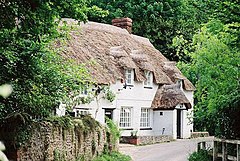
38:Cottages in Rampisham village
90:OS grid reference
21:Human settlement in England
1374:
1332:Grade II* listed buildings
436:. The parish includes the
424:. The village is sited on
16:Village in Dorset, England
1327:Grade II listed buildings
266:
244:
204:
43:
31:
1322:Grade I listed buildings
715:The Domesday Book Online
597:"Parish Population Data"
795:. Dorset Life Magazine
689:British History Online
556:Communications station
334:
194:Postcode district
106:Unitary authority
560:In November 1939 the
491:Victorian restoration
480:Bishop Odo of Bayeaux
448:Dorset County Council
329:
772:. Dorset OPC Project
652:Roland Gant (1980).
227:Dorset and Wiltshire
174:Sovereign state
1337:Scheduled monuments
959:(cities in italics)
931:Unitary authorities
743:. domesdaymap.co.uk
404:) is a village and
305: /
1358:Villages in Dorset
1056:Sturminster Newton
819:Portrait of Dorset
737:"Place: Rampisham"
501:. He also built a
335:
309:50.8186°N 2.6238°W
250:UK Parliament
1345:
1344:
1281:English Civil War
957:Major settlements
942:areas and suburbs
917:Ceremonial county
570:BBC World Service
324:
323:
124:Shire county
1365:
1297:Lord Lieutenants
1086:Wimborne Minster
925:
919:
909:
902:
895:
886:
861:
851:
845:
839:
833:
832:
811:
805:
804:
802:
800:
788:
782:
781:
779:
777:
766:
753:
752:
750:
748:
733:
727:
726:
724:
722:
707:
701:
700:
698:
696:
681:
668:
667:
649:
640:
639:
637:
635:
615:
609:
608:
606:
604:
593:
403:
402:
399:
398:
395:
392:
389:
386:
383:
374:
373:
370:
369:
366:
363:
360:
357:
354:
351:
348:
320:
319:
317:
316:
315:
314:50.8186; -2.6238
310:
306:
303:
302:
301:
298:
272:
168:
100:
99:
69:Location within
59:
58:
52:
36:
24:
1373:
1372:
1368:
1367:
1366:
1364:
1363:
1362:
1348:
1347:
1346:
1341:
1205:
1099:
1088:
971:Blandford Forum
958:
952:
926:
921:
915:
913:
870:
865:
864:
852:
848:
842:Ordnance Survey
840:
836:
829:
813:
812:
808:
798:
796:
790:
789:
785:
775:
773:
768:
767:
756:
746:
744:
735:
734:
730:
720:
718:
709:
708:
704:
694:
692:
683:
682:
671:
664:
654:Dorset Villages
651:
650:
643:
633:
631:
617:
616:
612:
602:
600:
595:
594:
587:
582:
558:
526:
456:
380:
376:
345:
341:
313:
311:
307:
304:
299:
296:
294:
292:
291:
290:
270:
262:
164:
154:
136:
118:
95:
94:
76:
75:
74:
73:
67:
66:
65:
64:
60:
39:
22:
17:
12:
11:
5:
1371:
1369:
1361:
1360:
1350:
1349:
1343:
1342:
1340:
1339:
1334:
1329:
1324:
1319:
1314:
1309:
1304:
1299:
1294:
1289:
1284:
1274:
1269:
1264:
1259:
1254:
1249:
1244:
1239:
1237:County Council
1234:
1229:
1224:
1219:
1213:
1211:
1207:
1206:
1204:
1203:
1198:
1193:
1188:
1183:
1178:
1173:
1168:
1163:
1158:
1153:
1148:
1143:
1138:
1133:
1128:
1123:
1118:
1113:
1107:
1105:
1101:
1100:
1098:
1097:
1083:
1078:
1073:
1068:
1063:
1058:
1053:
1048:
1043:
1038:
1033:
1028:
1023:
1018:
1013:
1008:
1003:
998:
993:
988:
983:
978:
973:
968:
962:
960:
954:
953:
951:
950:
945:
934:
932:
928:
927:
914:
912:
911:
904:
897:
889:
883:
882:
876:
869:
868:External links
866:
863:
862:
846:
834:
827:
815:Ralph Wightman
806:
783:
754:
728:
702:
669:
662:
641:
610:
584:
583:
581:
578:
566:Rampisham Down
557:
554:
525:
522:
495:Augustus Pugin
455:
452:
322:
321:
289:
288:
283:
278:
273:
271:List of places
267:
264:
263:
261:
260:
254:
252:
246:
245:
242:
241:
236:
230:
229:
224:
218:
217:
212:
206:
205:
202:
201:
196:
190:
189:
186:
180:
179:
178:United Kingdom
176:
170:
169:
162:
156:
155:
153:
152:
146:
144:
138:
137:
135:
134:
128:
126:
120:
119:
117:
116:
110:
108:
102:
101:
92:
86:
85:
82:
78:
77:
68:
62:
61:
54:
53:
47:
46:
45:
44:
41:
40:
37:
29:
28:
20:
15:
13:
10:
9:
6:
4:
3:
2:
1370:
1359:
1356:
1355:
1353:
1338:
1335:
1333:
1330:
1328:
1325:
1323:
1320:
1318:
1315:
1313:
1310:
1308:
1305:
1303:
1302:High Sheriffs
1300:
1298:
1295:
1293:
1290:
1288:
1285:
1282:
1278:
1275:
1273:
1270:
1268:
1265:
1263:
1260:
1258:
1255:
1253:
1250:
1248:
1245:
1243:
1240:
1238:
1235:
1233:
1230:
1228:
1225:
1223:
1220:
1218:
1215:
1214:
1212:
1208:
1202:
1199:
1197:
1194:
1192:
1191:Sydling Water
1189:
1187:
1184:
1182:
1179:
1177:
1174:
1172:
1169:
1167:
1164:
1162:
1159:
1157:
1154:
1152:
1149:
1147:
1144:
1142:
1139:
1137:
1134:
1132:
1129:
1127:
1124:
1122:
1119:
1117:
1114:
1112:
1109:
1108:
1106:
1102:
1096:
1095:
1091:
1087:
1084:
1082:
1079:
1077:
1074:
1072:
1069:
1067:
1064:
1062:
1059:
1057:
1054:
1052:
1049:
1047:
1044:
1042:
1039:
1037:
1034:
1032:
1029:
1027:
1024:
1022:
1019:
1017:
1014:
1012:
1009:
1007:
1004:
1002:
999:
997:
994:
992:
989:
987:
984:
982:
979:
977:
974:
972:
969:
967:
964:
963:
961:
955:
949:
946:
943:
939:
936:
935:
933:
929:
924:
918:
910:
905:
903:
898:
896:
891:
890:
887:
881:
877:
875:
872:
871:
867:
860:
859:0 7028 0327 8
856:
850:
847:
843:
838:
835:
830:
828:0 7090 0844 9
824:
820:
816:
810:
807:
794:
787:
784:
771:
765:
763:
761:
759:
755:
742:
741:Open Domesday
738:
732:
729:
716:
712:
706:
703:
690:
686:
680:
678:
676:
674:
670:
665:
663:0-7091-8135-3
659:
655:
648:
646:
642:
629:
625:
621:
614:
611:
598:
592:
590:
586:
579:
577:
575:
571:
567:
563:
555:
553:
551:
547:
543:
539:
535:
531:
523:
521:
519:
518:wayside cross
514:
512:
508:
504:
500:
496:
492:
488:
483:
481:
477:
473:
469:
468:Domesday Book
464:
461:
453:
451:
449:
445:
443:
439:
435:
432:hills of the
431:
427:
423:
419:
415:
411:
407:
401:
372:
339:
332:
328:
318:
287:
284:
282:
279:
277:
274:
269:
268:
265:
259:
256:
255:
253:
251:
243:
240:
239:South Western
237:
235:
228:
225:
223:
216:
213:
211:
200:
197:
195:
187:
185:
177:
175:
167:
163:
161:
151:
148:
147:
145:
143:
133:
130:
129:
127:
125:
115:
112:
111:
109:
107:
98:
93:
91:
83:
79:
72:
51:
42:
35:
25:
19:
1092:
1089:
1001:Corfe Mullen
996:Christchurch
849:
837:
818:
809:
797:. Retrieved
786:
774:. Retrieved
745:. Retrieved
740:
731:
719:. Retrieved
714:
711:"Dorset H–R"
705:
693:. Retrieved
688:
653:
632:. Retrieved
623:
613:
601:. Retrieved
559:
527:
515:
511:Thomas Hardy
484:
465:
457:
446:
441:
434:Dorset Downs
416:in southern
406:civil parish
337:
336:
18:
1222:Settlements
1041:Shaftesbury
976:Bournemouth
770:"Rampisham"
530:River Frome
312: /
258:West Dorset
1272:Healthcare
1051:Stalbridge
1026:Lyme Regis
1021:Highcliffe
1016:Gillingham
1006:Dorchester
991:Chickerell
986:Broadstone
966:Beaminster
580:References
542:Dorchester
476:Tollerford
458:In 1799 a
422:Dorchester
331:Pugin Hall
297:50°49′07″N
188:Dorchester
150:South West
81:Population
1317:Transport
1262:Geography
1090:See also:
1046:Sherborne
534:West Hill
524:Geography
503:a rectory
426:greensand
338:Rampisham
300:2°37′26″W
234:Ambulance
184:Post town
84:110
63:Rampisham
27:Rampisham
1352:Category
1232:Churches
1081:Weymouth
1011:Ferndown
981:Bridport
817:(1983).
799:31 March
776:31 March
695:30 March
628:Archived
550:Somerset
538:Bridport
487:medieval
97:ST562022
1307:Museums
1292:Tourism
1287:Schools
1277:History
1257:Geology
1242:Economy
1227:Beaches
1196:Tarrant
1076:Wareham
1071:Verwood
1061:Swanage
747:5 April
721:5 April
634:23 June
624:YouTube
603:7 March
499:chancel
472:hundred
466:In the
454:History
418:England
408:in the
281:England
166:England
160:Country
1312:People
1247:Places
1210:Topics
1181:Piddle
1131:Bourne
1104:Rivers
1031:Merley
948:Dorset
923:Dorset
857:
825:
660:
574:Europe
546:Yeovil
442:Uphall
438:hamlet
414:Dorset
410:county
286:Dorset
215:Dorset
210:Police
142:Region
132:Dorset
114:Dorset
71:Dorset
1267:SSSIs
1186:Stour
1176:Moors
1171:Hooke
1166:Frome
1161:Crane
1156:Corfe
1146:Cerne
1136:Bride
1116:Asker
1111:Allen
1066:Upton
1036:Poole
460:Roman
430:chalk
1217:Flag
1151:Char
1141:Brit
1121:Avon
855:ISBN
823:ISBN
801:2014
778:2014
749:2014
723:2014
697:2014
658:ISBN
636:2022
605:2015
507:nave
222:Fire
1201:Wey
1126:Axe
920:of
572:in
562:BBC
548:in
474:of
440:of
412:of
375:or
199:DT2
1354::
757:^
739:.
713:.
687:.
672:^
644:^
626:.
622:.
588:^
552:.
520:.
513:.
482:.
397:əm
368:əm
276:UK
1283:)
1279:(
944:)
940:(
908:e
901:t
894:v
831:.
803:.
780:.
751:.
725:.
699:.
666:.
638:.
607:.
400:/
394:s
391:n
388:æ
385:r
382:ˈ
379:/
371:/
365:ʃ
362:ɪ
359:p
356:m
353:æ
350:r
347:ˈ
344:/
340:(
Text is available under the Creative Commons Attribution-ShareAlike License. Additional terms may apply.