312:
75:
320:
277:
1010:
51:
462:
144:
82:
334:
Surapura is known for the Shree
Venugopala Swami Temple. Even today, all the disciplines offered in the Tirumala Temple at Tirupati were started from the contributions of the then Surapura (Shorapur) kings. They never visit the Tirumala temple, but a representative would be sent on their behalf. From
331:, Surapura had a population of 43,591. Males constituted 51% of the population and females 49%. Surapura has an average literacy rate of 55%, lower than the national average of 59.5%: male literacy is 65% and female literacy is 46%. In Surapura, 16% of the population is under 6 years of age.
342:
The major occupation of the people in and around
Surapura is farming. Surapura is a large producer of cotton, pulses and paddy. Major attractions are the fort (Durbaar), Taylor Manzil, Gopalswami Temple, Jain Temple and Devar Baavi.
1078:
1059:
450:
1088:
180:
376:
106:
1083:
74:
428:
292:
156:
1052:
443:
335:
1703 the bedara (tribal) kingdom rose and ruled it up to 1858, with the last king being Raja
Nalvadi Venkatappa Naayaka.
265:
168:
1045:
436:
311:
586:
300:
972:
400:
356:
852:
319:
50:
377:"Census of India 2001: Data from the 2001 Census, including cities, villages and towns (Provisional)"
982:
767:
336:
237:
380:
977:
909:
709:
644:
581:
245:
538:
509:
802:
624:
1029:
827:
777:
719:
649:
629:
556:
504:
1017:
939:
782:
669:
659:
614:
519:
494:
466:
288:
276:
299:
and a historical place. Surapura was the land of the famous prince of
Surapura aasthana,
992:
901:
882:
797:
1072:
987:
729:
724:
674:
967:
893:
822:
654:
634:
404:
1009:
914:
792:
679:
571:
121:
108:
1021:
832:
787:
734:
591:
546:
499:
470:
296:
233:
228:
161:
867:
807:
762:
694:
684:
664:
639:
619:
601:
566:
561:
514:
173:
17:
837:
812:
772:
704:
699:
689:
609:
576:
551:
221:
185:
931:
842:
817:
757:
749:
739:
714:
480:
328:
315:
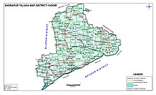
Shorapur Taluk Zilla
Panchayat Map before creation of Hunasagi Taluk
1025:
318:
310:
275:
149:
432:
323:
Shorapur Taluk
Panchayat Map before creation of Hunasagi Taluk
303:, the young rebel freedom fighter against British rule.
1033:
421:
280:
Shorapur Taluk Map before creation of
Hunasagi Taluk
958:
881:
866:
851:
748:
600:
537:
528:
487:
264:
256:
244:
227:
217:
212:
204:
199:
191:
179:
167:
155:
137:
34:
408:, by M. Taylor. Ed. by his daughter (A.M. Taylor)
1053:
444:
8:
379:. Census Commission of India. Archived from
339:is located about 10 km from Surapura.
1060:
1046:
534:
451:
437:
429:
31:
368:
351:The town has been vividly described in
243:
226:
211:
198:
190:
136:
101:
67:
59:
47:
1016:This article related to a location in
422:"Official Website of Yadgir District"
263:
255:
216:
203:
178:
166:
154:
7:
1006:
1004:
359:and also Jamiya Masjid of Timmapur.
63:Surpur Paddy, Pulses and Cotton City
1079:Cities and towns in Yadgir district
1032:. You can help Knowledge (XXG) by
25:
1008:
460:
142:
81:
80:
73:
49:
1089:Yadgir district geography stubs
1:
94:Location in Karnataka, India
1105:
1084:Taluks in Yadgiri district
1003:
410:. Oxford University, 1882.
287:, is a city and taluka in
195:428 m (1,404 ft)
477:
102:
68:
60:
48:
41:
29:City in Karnataka, India
355:, the autobiography of
324:
316:
301:Raja Venkatappa Nayaka
281:
181:Lok Sabha Constituency
401:Philip Meadows Taylor
357:Philip Meadows Taylor
322:
314:
279:
218: • Official
983:Bonal Bird Sanctuary
406:The story of my life
353:The story of my life
337:Bonal Bird Sanctuary
266:Vehicle registration
973:Lumbini Park Yadgir
959:Parks, reserves and
592:Wanadurga (Wandurg)
118: /
961:places of interest
325:
317:
282:
205: • Total
61:Nickname(s):
55:Surapura Taluk Map
1041:
1040:
1001:
1000:
954:
953:
853:Gurumitkal Taluka
531:other settlements
515:Shorapur (Surpur)
327:As of 2001 India
274:
273:
16:(Redirected from
1096:
1062:
1055:
1048:
1012:
1005:
720:Narayanpur Rural
535:
488:Cities and towns
465:
464:
463:
453:
446:
439:
430:
425:
393:
392:
390:
388:
373:
148:
146:
145:
133:
132:
130:
129:
128:
123:
119:
116:
115:
114:
111:
84:
83:
77:
53:
32:
21:
1104:
1103:
1099:
1098:
1097:
1095:
1094:
1093:
1069:
1068:
1067:
1066:
1018:Yadgir district
1002:
997:
960:
950:
877:
862:
847:
744:
602:Shorapur Taluka
596:
539:Shahapur Taluka
530:
524:
495:Bhimarayanagudi
483:
473:
467:Yadgir district
461:
459:
457:
420:
417:
397:
396:
386:
384:
383:on 16 June 2004
375:
374:
370:
365:
349:
309:
289:Yadgir district
252:
143:
141:
126:
124:
122:16.52°N 76.76°E
120:
117:
112:
109:
107:
105:
104:
98:
97:
96:
95:
92:
91:
90:
89:
85:
64:
56:
44:
37:
30:
23:
22:
15:
12:
11:
5:
1102:
1100:
1092:
1091:
1086:
1081:
1071:
1070:
1065:
1064:
1057:
1050:
1042:
1039:
1038:
1013:
999:
998:
996:
995:
993:Vanadurga Fort
990:
988:Narayanpur Dam
985:
980:
975:
970:
964:
962:
956:
955:
952:
951:
949:
948:
945:
942:
937:
936:Tewar Wadagera
934:
929:
926:
923:
920:
917:
912:
907:
904:
899:
896:
891:
887:
885:
883:Wadgera Taluka
879:
878:
876:
875:
872:
870:
868:Hunsagi Taluka
864:
863:
861:
860:
857:
855:
849:
848:
846:
845:
840:
835:
830:
825:
820:
815:
810:
805:
800:
795:
790:
785:
780:
775:
770:
765:
760:
754:
752:
746:
745:
743:
742:
737:
732:
727:
722:
717:
712:
707:
702:
697:
692:
687:
682:
677:
672:
667:
662:
657:
652:
647:
642:
637:
632:
627:
622:
617:
612:
606:
604:
598:
597:
595:
594:
589:
584:
579:
574:
569:
564:
559:
554:
549:
543:
541:
532:
526:
525:
523:
522:
517:
512:
507:
502:
497:
491:
489:
485:
484:
478:
475:
474:
458:
456:
455:
448:
441:
433:
427:
426:
416:
415:External links
413:
412:
411:
395:
394:
367:
366:
364:
361:
348:
345:
308:
305:
291:in the Indian
272:
271:
268:
262:
261:
258:
257:Telephone code
254:
253:
250:
248:
242:
241:
231:
225:
224:
219:
215:
214:
210:
209:
206:
202:
201:
197:
196:
193:
189:
188:
183:
177:
176:
171:
165:
164:
159:
153:
152:
139:
135:
134:
100:
99:
93:
87:
86:
79:
78:
72:
71:
70:
69:
66:
65:
62:
58:
57:
54:
46:
45:
42:
39:
38:
35:
28:
24:
14:
13:
10:
9:
6:
4:
3:
2:
1101:
1090:
1087:
1085:
1082:
1080:
1077:
1076:
1074:
1063:
1058:
1056:
1051:
1049:
1044:
1043:
1037:
1035:
1031:
1027:
1023:
1019:
1014:
1011:
1007:
994:
991:
989:
986:
984:
981:
979:
978:Hattikuni Dam
976:
974:
971:
969:
966:
965:
963:
957:
946:
943:
941:
938:
935:
933:
930:
927:
924:
921:
918:
916:
913:
911:
908:
905:
903:
900:
897:
895:
892:
889:
888:
886:
884:
880:
874:
873:
871:
869:
865:
859:
858:
856:
854:
850:
844:
841:
839:
836:
834:
831:
829:
826:
824:
821:
819:
816:
814:
811:
809:
806:
804:
801:
799:
796:
794:
791:
789:
786:
784:
781:
779:
776:
774:
771:
769:
766:
764:
761:
759:
756:
755:
753:
751:
750:Yadgir Taluka
747:
741:
738:
736:
733:
731:
728:
726:
723:
721:
718:
716:
713:
711:
708:
706:
703:
701:
698:
696:
693:
691:
688:
686:
683:
681:
678:
676:
673:
671:
668:
666:
663:
661:
658:
656:
653:
651:
648:
646:
643:
641:
638:
636:
633:
631:
628:
626:
623:
621:
618:
616:
613:
611:
608:
607:
605:
603:
599:
593:
590:
588:
585:
583:
580:
578:
575:
573:
570:
568:
565:
563:
560:
558:
555:
553:
550:
548:
545:
544:
542:
540:
536:
533:
527:
521:
518:
516:
513:
511:
508:
506:
503:
501:
498:
496:
493:
492:
490:
486:
482:
479:District HQ:
476:
472:
468:
454:
449:
447:
442:
440:
435:
434:
431:
423:
419:
418:
414:
409:
407:
402:
399:
398:
382:
378:
372:
369:
362:
360:
358:
354:
346:
344:
340:
338:
332:
330:
321:
313:
306:
304:
302:
298:
294:
290:
286:
278:
269:
267:
259:
249:
247:
239:
235:
232:
230:
223:
220:
207:
194:
187:
184:
182:
175:
172:
170:
163:
160:
158:
151:
140:
131:
103:Coordinates:
76:
52:
40:
33:
27:
19:
1034:expanding it
1015:
725:Peth Ammapur
675:Jogandabhavi
529:Villages and
405:
385:. Retrieved
381:the original
371:
352:
350:
341:
333:
326:
307:Demographics
284:
283:
127:16.52; 76.76
26:
968:Yadgir Fort
947:Ulle Sugoor
922:Kadamgera B
894:Bendebembli
823:Ramasamudra
655:Chikanhalli
645:Bhagyanagar
635:Bardevanhal
125: /
1073:Categories
915:Hayyal (B)
910:Gundgurthi
793:Hedgimadra
680:Kachaknoor
572:Hattigudur
387:1 November
363:References
347:Literature
200:Population
1022:Karnataka
833:Thangunda
788:Hattikuni
768:Badepalli
735:Wagingera
547:Agastihal
500:Gurmatkal
471:Karnataka
297:Karnataka
229:Time zone
213:Languages
192:Elevation
162:Karnataka
944:Tadabidi
928:Kurkunda
906:Gulsaram
808:Munderga
803:Mailapur
778:Gopalpur
763:Azalapur
710:Mailapur
695:Kembhavi
685:Kanhalli
665:Hunasagi
640:Baichbal
620:Agthirth
582:Rastapur
567:Gogipeth
562:Gogikona
505:Saidapur
285:Shorapur
234:UTC+5:30
174:Yadagiri
169:District
88:Shorapur
36:Shorapur
18:Shorapur
919:Halgera
838:Yelahar
813:Paspool
783:Halgera
773:Badiyal
705:Kodekal
700:Kodalgi
690:Kekkera
660:Devapur
625:Ainapur
610:Adwadgi
577:Hoskera
552:Agnihal
520:Wadgera
510:Shahpur
222:Kannada
208:412,291
186:Raichur
138:Country
113:76°46′E
110:16°31′N
940:Tumkur
932:Naikal
925:Konkal
843:Yergol
818:Putpak
798:Konkal
758:Achola
740:Wajjal
715:Marnal
630:Aldhal
557:Aldhal
481:Yadgir
329:census
251:585224
147:
1028:is a
1026:India
902:Gonal
898:Bilar
890:Aikur
828:Talak
730:Sugur
670:Gonal
650:Bonal
587:Sagar
293:state
270:KA 33
260:08443
157:State
150:India
1030:stub
615:Agni
389:2008
43:City
295:of
246:PIN
238:IST
1075::
1024:,
1020:,
469:,
403:.
1061:e
1054:t
1047:v
1036:.
452:e
445:t
438:v
424:.
391:.
240:)
236:(
20:)
Text is available under the Creative Commons Attribution-ShareAlike License. Additional terms may apply.