28:
141:
184:
148:
112:
177:
105:
544:
601:
319:
372:
and
Southballo hills and the ridge north and west of Long Loch; Lundie Craigs are a significant southeast facing exposure of this formation. They are also found across the larger part of Carlunie Hill and Berry Hillock together with Kinpurney Hill. The overlying Scone Sandstone forms the hill of
356:
which interleave with the rocks of the overlying Ochil
Volcanic Formation. They form the bulk of the hills along the southern margin of the range from Scotston Hill and the eastern slopes of Balkello Hill in the west, through Craigowl Hill, much of Gallow Hill, Ironside Hill and Finlarg Hill to
357:
Kincaldrum Hill in the east, together with the outlying
Fothringham Hill and Carrot Hill ridge. The Dundee Flagstones were intruded by rocks of the 'Midland Valley Siluro-Devonian Mafic Intrusion Suite'; these outcrop on parts of Auchterhouse and Scotston hills, Blacklaw and West Mains hills.
291:
was built in the 18th century and can be seen for many miles on the
Strathmore side of the Sidlaws. There is a local legend that a poacher named Brandon Henderson lived as a hermit in the tower for seven years in order to win a £100 bet.
399:, which formed over millions of years in cavities (originally gas bubbles) in the volcanic lava which formed the hills, are occasionally to be found weathered out of the rock in the surrounding fields.
671:
666:
585:
661:
140:
691:
642:
60:
686:
27:
578:
176:
498:
104:
696:
676:
571:
635:
53:
681:
628:
307:
385:
381:
452:
543:
551:
280:
247:
161:
612:
555:
331:
270:
608:
502:
369:
251:
235:
223:
125:
495:
361:
288:
266:
655:
423:
342:
262:
231:
418:
327:
255:
600:
514:
299:
219:
265:, north of Dundee, is the highest of the Sidlaws. Points of interest include
75:
62:
475:
413:
408:
365:
349:
345:
318:
284:
376:
Much of the lower ground around and within the hills is covered by glacial
476:"Kinpurnie Tower (C) Douglas Nelson :: Geograph Britain and Ireland"
389:
353:
335:
227:
197:
275:
396:
303:
243:
239:
43:
373:
Castleward and underlies the low ground of
Strathmore to the north.
317:
377:
616:
559:
442:
United
Kingdom Ordnance Survey Map, Landranger (2005)
388:
from the late stages of the ice age and post-glacial
91:
52:
42:
37:
20:
230:that extend for 30 miles (45 km) from
360:The Ochil Volcanics form the sometimes craggy
341:The Dundee Flagstones are a mix of slabby and
636:
579:
8:
643:
629:
586:
572:
17:
334:originating during the early part of the
672:Mountains and hills of Perth and Kinross
218:are a range of hills in the counties of
435:
667:Mountains and hills of Angus, Scotland
326:The Sidlaws are formed from a mix of
7:
662:Hills of the Scottish Midland Valley
597:
595:
540:
538:
283:, which was the site of an ancient
615:. You can help Knowledge (XXG) by
558:. You can help Knowledge (XXG) by
14:
692:Perth and Kinross geography stubs
302:" marching tune composed for the
599:
542:
496:Tom Hughes and His Border Fiddle
182:
175:
146:
139:
110:
103:
26:
183:
147:
111:
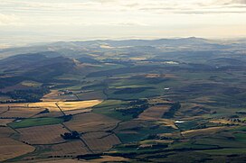
32:Aerial view of the Sidlaw Hills
1:
166:Show map of Perth and Kinross
455:. The Gazetteer for Scotland
322:The summit of Dunsinane Hill
287:. The ruined observatory on
687:Mountain ranges of Scotland
517:. British Geological Survey
261:At 1492 feet (455 metres),
713:
594:
537:
48:455 m (1,493 ft)
96:
25:
501:28 February 2007 at the
242:. A continuation of the
298:is also the name of a "
611:location article is a
554:location article is a
386:Glaciofluvial deposits
323:
250:to the north from the
697:Angus geography stubs
677:Volcanism of Scotland
395:Beautifully coloured
392:are also widespread.
321:
254:on the shore of the
202:Show map of Scotland
72: /
682:Devonian volcanism
515:"GeoIndex Onshore"
380:, a legacy of the
324:
38:Highest point
624:
623:
567:
566:
552:Perth and Kinross
474:Nelson, Douglas.
332:sedimentary rocks
306:by Jim Watson of
281:Auchterhouse Hill
212:
211:
162:Perth and Kinross
130:Show map of Angus
704:
645:
638:
631:
603:
596:
588:
581:
574:
546:
539:
527:
526:
524:
522:
511:
505:
493:
487:
486:
484:
482:
471:
465:
464:
462:
460:
449:
443:
440:
246:, they separate
203:
186:
185:
179:
167:
150:
149:
143:
131:
114:
113:
107:
87:
86:
84:
83:
82:
77:
76:56.500°N 3.167°W
73:
70:
69:
68:
65:
30:
18:
712:
711:
707:
706:
705:
703:
702:
701:
652:
651:
650:
649:
593:
592:
536:
531:
530:
520:
518:
513:
512:
508:
503:Wayback Machine
494:
490:
480:
478:
473:
472:
468:
458:
456:
451:
450:
446:
441:
437:
432:
405:
316:
269:, mentioned in
252:Carse of Gowrie
238:, northeast to
208:
207:
206:
205:
204:
201:
200:
194:
193:
192:
191:
187:
170:
169:
168:
165:
164:
158:
157:
156:
155:
151:
134:
133:
132:
129:
128:
122:
121:
120:
119:
115:
80:
78:
74:
71:
66:
63:
61:
59:
58:
33:
12:
11:
5:
710:
708:
700:
699:
694:
689:
684:
679:
674:
669:
664:
654:
653:
648:
647:
640:
633:
625:
622:
621:
604:
591:
590:
583:
576:
568:
565:
564:
547:
535:
534:External links
532:
529:
528:
506:
488:
466:
453:"Sidlaw Hills"
444:
434:
433:
431:
428:
427:
426:
421:
416:
411:
404:
401:
315:
312:
289:Kinpurnie Hill
267:Dunsinane Hill
210:
209:
195:
189:
188:
181:
180:
174:
173:
172:
171:
159:
153:
152:
145:
144:
138:
137:
136:
135:
123:
117:
116:
109:
108:
102:
101:
100:
99:
98:
97:
94:
93:
89:
88:
81:56.500; -3.167
56:
50:
49:
46:
40:
39:
35:
34:
31:
23:
22:
13:
10:
9:
6:
4:
3:
2:
709:
698:
695:
693:
690:
688:
685:
683:
680:
678:
675:
673:
670:
668:
665:
663:
660:
659:
657:
646:
641:
639:
634:
632:
627:
626:
620:
618:
614:
610:
605:
602:
598:
589:
584:
582:
577:
575:
570:
569:
563:
561:
557:
553:
548:
545:
541:
533:
516:
510:
507:
504:
500:
497:
492:
489:
477:
470:
467:
454:
448:
445:
439:
436:
429:
425:
424:Wester Denoon
422:
420:
417:
415:
412:
410:
407:
406:
402:
400:
398:
393:
391:
387:
383:
379:
374:
371:
367:
363:
358:
355:
351:
347:
344:
339:
337:
333:
329:
320:
313:
311:
310:(1868–1931).
309:
305:
301:
297:
293:
290:
286:
282:
278:
277:
272:
271:Shakespeare's
268:
264:
263:Craigowl Hill
259:
257:
253:
249:
245:
241:
237:
233:
232:Kinnoull Hill
229:
225:
221:
217:
199:
178:
163:
142:
127:
106:
95:
90:
85:
57:
55:
51:
47:
45:
41:
36:
29:
24:
19:
16:
617:expanding it
606:
560:expanding it
549:
519:. Retrieved
509:
491:
479:. Retrieved
469:
457:. Retrieved
447:
438:
419:Newtyle Hill
394:
382:last ice age
375:
359:
343:cross-bedded
340:
325:
296:Sidlaw Hills
295:
294:
274:
260:
215:
213:
196:Location in
160:Location in
124:Location in
15:
362:King's Seat
308:Blairgowrie
300:Schottische
79: /
54:Coordinates
656:Categories
430:References
370:Northballo
350:siltstones
348:with some
346:sandstones
248:Strathmore
220:Perthshire
414:Gask Hill
409:B954 road
366:Gask Hill
354:mudstones
285:hill fort
92:Geography
44:Elevation
499:Archived
459:30 March
403:See also
390:alluvium
338:period.
336:Devonian
228:Scotland
198:Scotland
521:17 July
481:15 July
328:igneous
314:Geology
276:Macbeth
234:, near
216:Sidlaws
190:Sidlaws
154:Sidlaws
118:Sidlaws
64:56°30′N
21:Sidlaws
397:agates
304:fiddle
279:, and
244:Ochils
240:Forfar
67:3°10′W
609:Angus
607:This
550:This
273:play
236:Perth
224:Angus
126:Angus
613:stub
556:stub
523:2020
483:2014
461:2021
378:till
352:and
330:and
222:and
214:The
258:.
256:Tay
226:in
658::
384:.
368:,
364:,
644:e
637:t
630:v
619:.
587:e
580:t
573:v
562:.
525:.
485:.
463:.
Text is available under the Creative Commons Attribution-ShareAlike License. Additional terms may apply.