71:
53:
115:
78:
85:
422:
60:
229:
925:
554:
544:
300:
Due to its elevation it is also the site of the oldest home in
Washington, D.C., Charles Jones's home, called “The Rest,” is believed to have originally been built around 1700 and significantly expanded around 1800. This home stayed in the Jones family until 1920 when the
1779:
https://mobilitylab.org/transportation-demand-management/commuter-services/how-washington-dc-universities-get-commuters-out-of-cars/https://mobilitylab.org/transportation-demand-management/commuter-services/how-washington-dc-universities-get-commuters-out-of-cars/
266:
In 1790, locals began calling the neighborhood "Tennally's Town" after area tavern owner John
Tennally. Over time, the spelling has evolved and by the 19th century the area was commonly known by its current name, although the spelling
531:, and Yuma Street. On Tenley Circle itself is St. Ann's Catholic Church, a large imposing stone church which serves area Catholics. On the opposite side of the circle is Wisconsin Avenue Baptist Church. American University's
361:
on
Wisconsin Avenue at Albemarle Street. At the time the store was notable for its size and for its 300-car rooftop parking lot. In the 1990s, Sears abandoned its retail operation at the location and the building was used by
633:
358:
316:
developed into an
African-American community. This community existed in tension with the white residents of Tenleytown, as well as major landholders. Eventually, a coalition of groups persuaded the
982:
851:
37:
1797:
286:
to protect the capital against invasions. It proved to be the crucial lookout point for preventing a siege of
Washington, because it is the highest natural elevation point in the
868:
885:
1792:
1778:
820:
975:
114:
837:
96:
504:. American University offers a free shuttle bus between campus and the Tenleytown metro station at 40th and Albemarle Street, runs between the Metro stop and
335:
Within the park boundaries lies the highest natural point in the
District of Columbia, 409 feet above sea level. Fort Reno also hosts community gardens, free
637:
968:
350:
in the winter, and tennis courts, playing fields, and dog-walkers year round. Jackson-Reed HS baseball now uses the ball field for its home games.
1761:
329:
601:
1585:
1221:
955:
645:
517:
617:
70:
1736:
1650:
1105:
1019:
1014:
906:
889:
872:
855:
597:
564:
1645:
1231:
1049:
132:
1504:
1039:
991:
938:
821:
https://mobilitylab.org/transportation-demand-management/commuter-services/how-washington-dc-universities-get-commuters-out-of-cars/
715:
649:
297:. The last remains of Fort Reno were removed about 1900, when the land owned by the Dyer family was being prepared for a reservoir.
104:
433:, which houses a baseball field and a soccer field. Due to the high altitude, the neighborhood is home to nearly all of the city's
1680:
1443:
1433:
1236:
1226:
387:
1560:
1519:
1408:
1378:
1261:
1181:
1110:
1059:
52:
1716:
1610:
1413:
1312:
1292:
1166:
317:
272:
320:
and the
Federal Government to clear the community for segregated neighborhood resources: Deal Middle School, a park, and a
1635:
1600:
1524:
1453:
1322:
1282:
1100:
1741:
1630:
1625:
1615:
1555:
1468:
1398:
1388:
1383:
1373:
1317:
1302:
1246:
1080:
1044:
800:
779:
756:
629:
586:
279:
237:
477:
started to build an even higher tower, 756 feet (about 230 meters) tall, which could support 169 transmitters, but the
1766:
1731:
1726:
1711:
1620:
1458:
1403:
1332:
1135:
1085:
1054:
513:
501:
305:(local grocers) bought the home. In 1974, the current family owning the home bought the house and still own it today.
252:
425:
The
Cityline Building, home to The Container Store, condominiums, and the west entrance of the Tenleytown-AU Station
1756:
1685:
1655:
1540:
1428:
1418:
1186:
1156:
371:
957:(Historic Preservation Review Board's staff report on proposed multi-property historic designation for Tenleytown)
494:
394:
17:
1357:
621:
532:
1352:
1151:
1130:
661:
657:
579:
571:
557:
547:
520:, 33, 30S, 30N, 37, D32, H2, H3, H4, M4, W45, and W47 serve the neighborhood, all making stops at the station.
490:
386:
underground, located within the parking garage that serves the aforementioned stores. The west entrance to the
207:
1201:
1125:
943:
653:
641:
593:, whose 2021 campus expansion allowed its lower and middle schools to join the high school in Tenleytown.
434:
1499:
1206:
949:
681:
590:
367:
77:
1514:
1327:
1256:
1216:
930:
478:
421:
84:
59:
1802:
1438:
1115:
805:
784:
761:
505:
398:
379:
228:
1665:
1307:
1191:
309:
283:
508:'s main campus. The station is located in the heart of the neighborhood at the intersection of
1565:
1161:
711:
1721:
1675:
1590:
1570:
1494:
1297:
995:
731:
605:
528:
509:
498:
294:
287:
256:
177:
120:
100:
535:, on the site of the former Immaculata School, also bounds the western edge of the circle.
366:
hardware until its demise in the late 1990s. In the 2000s, the building was converted to a
1751:
1595:
1545:
1393:
1287:
481:
government reversed its position, and the incomplete tower was demolished in August 2006.
1660:
1463:
1251:
1211:
1171:
1024:
833:
474:
430:
402:
313:
233:
200:
1786:
1550:
1484:
1448:
1347:
1337:
1277:
1090:
1034:
524:
354:
302:
241:
167:
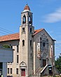
103:(right); bottom: Metropolitan Memorial Church (left), St. Ann's Church (center), and
960:
1640:
1489:
1120:
1095:
1029:
1009:
553:
383:
1746:
1670:
1605:
1580:
1196:
1176:
393:
In 2010, the Top of the Town: Tenleytown
Heritage Trail opened. Starting at the
325:
321:
16:
This article is about the
Washington D.C. neighborhood. For the Metro stop, see
1706:
1342:
920:
336:
147:
134:
1701:
819:{{Cite web | How Washington, DC universities get commuters out of cars |url=
543:
442:
363:
902:
1575:
1423:
1075:
625:
375:
347:
339:
282:, one of the forts that formed a ring around Washington, D.C. during the
470:
462:
458:
450:
446:
585:
Tenleytown is the location of several independent schools, including
406:
343:
638:
Chesapeake and Potomac Telephone Company, Cleveland-Emerson Exchange
271:
continued to be used for some time in certain capacities, including
552:
542:
420:
227:
1509:
466:
454:
438:
390:
is at the front of the building across from Whole Foods Market.
964:
823:|access-date=2023-09-12 |website=Mobility Lab |language=en-US}}
708:
Tenleytown, D.C. : Country Village into City Neighborhood
410:
232:
Aerial view of Tenleytown from the southwest, looking towards
429:
The neighborhood is home to the highest point in Washington,
656:. There are two educational properties listed on the NRHP:
220:
332:, is one of the few remaining traces of this community.
632:. Commercial properties listed on the NRHP include the
293:
Fort Reno was decommissioned with the surrender of the
939:
Cultural Tourism entry for African-American landmarks
801:"Steel 'Monstrosity' In Tenleytown To Be Dismantled"
353:
Tenleytown was transformed on October 2, 1941, when
1694:
1533:
1477:
1366:
1270:
1144:
1068:
1002:
527:which lies at the intersection of Nebraska Avenue,
216:
206:
196:
191:
183:
173:
163:
28:
397:, the trail passes neighborhood landmarks such as
378:(later closed and replaced by a Target store) and
437:including the studios and/or towers for WRC-TV,
774:
772:
616:Several Tenleytown landmarks are listed on the
370:complex called Cityline at Tenley, with luxury
952:- History blog post by local blog Ghosts of DC
946:- History blog post by local blog Ghosts of DC
838:Washington Metropolitan Area Transit Authority
710:. Washington, DC: Tennally Press. p. 64.
1798:Neighborhoods in Northwest (Washington, D.C.)
976:
8:
604:, whose 2011 building sits at the corner of
682:"Tenleytown, Tennallytown, or Tenallytown?"
634:Sears, Roebuck and Company Department Store
983:
969:
961:
620:(NRHP). Residential listings include the
25:
950:Tenleytown, Tennallytown, or Tenallytown?
1793:1790 establishments in the United States
944:When Did Tennallytown Become Tenleytown?
673:
215:
205:
190:
162:
127:
111:
43:
755:Forgey, Benjamin (September 3, 2005).
602:Tenley-Friendship Neighborhood Library
646:Immaculata Seminary Historic District
195:
182:
172:
7:
799:Schwartzman, Paul (March 18, 2006).
618:National Register of Historic Places
374:(The Cityline) on the top levels, a
123:, with Tenleytown highlighted in red
907:District of Columbia Public Library
890:District of Columbia Public Schools
873:District of Columbia Public Schools
856:District of Columbia Public Schools
736:www.tenleytownhistoricalsociety.org
732:"the Tenleytown Historical Society"
598:District of Columbia Public Library
565:District of Columbia Public Schools
14:
650:Eldbrooke United Methodist Church
1055:U Street Corridor (Cardozo/Shaw)
923:
909:. Retrieved on October 21, 2009.
113:
83:
76:
69:
58:
51:
38:Neighborhood of Washington, D.C.
523:The neighborhood is defined by
640:. Religious listings include
251:is a historic neighborhood in
1:
892:. Retrieved on May 27, 2018.
875:. Retrieved on May 27, 2018.
858:. Retrieved on May 27, 2018.
630:Grant Road Historic District
587:National Presbyterian School
328:building, built in 1903 for
318:unelected government of D.C.
888:" (2016-2017 School Year).
871:" (2016-2017 School Year).
854:" (2016-2017 School Year).
395:Tenleytown–AU metro station
1819:
1454:Stronghold-Metropolis View
869:Middle School Boundary Map
706:Helm, Judith Beck (2000).
567:. Tenleytown is zoned to:
563:The area is served by the
197: • Councilmember
23:Place in the United States
15:
622:N. Webster Chappell House
533:Washington College of Law
330:African-American students
128:
112:
97:Washington College of Law
44:
35:
1353:Sixteenth Street Heights
1152:American University Park
1131:Southwest Federal Center
886:High School Boundary Map
780:"Digital Signal Sources"
662:Janney Elementary School
658:Jackson-Reed High School
580:Jackson-Reed High School
576:Alice Deal Middle School
572:Janney Elementary School
558:Janney Elementary School
548:Jackson-Reed High School
491:American University Park
489:Tenleytown and adjacent
382:at street level, and an
278:The area is the site of
221:http://tenleytowndc.org/
757:"Top Floor: Home Goods"
608:and Albemarle Streets.
244:is at the bottom right.
642:Convent de Bon Secours
560:
550:
512:and Albemarle Street.
435:radio masts and towers
426:
245:
1500:Mount Vernon Triangle
1207:Massachusetts Heights
903:Hours & Locations
591:Georgetown Day School
556:
546:
465:, and radio stations
424:
413:-affiliated station.
405:, and the studios of
368:mixed-use development
231:
18:Tenleytown–AU station
1762:Washington Highlands
1515:Southwest Waterfront
1328:North Portal Estates
1257:Woodland Normanstone
1217:North Cleveland Park
931:United States portal
600:system operates the
479:District of Columbia
359:its department store
288:District of Columbia
1439:North Michigan Park
1116:Mount Vernon Square
806:The Washington Post
785:The Washington Post
762:The Washington Post
506:American University
399:American University
380:The Container Store
275:through the 1920s.
144: /
1666:Northeast Boundary
1586:East River Heights
1308:Fort Stevens Ridge
1222:Observatory Circle
1192:Friendship Heights
852:Elementary Schools
654:Methodist Cemetery
652:and its adjoining
612:Historic landmarks
561:
551:
493:are served by the
427:
310:American Civil War
284:American Civil War
246:
1775:
1774:
1566:Central Northeast
1162:Cathedral Heights
1106:Sheridan-Kalorama
1020:Kalorama Triangle
417:Geographic impact
226:
225:
148:38.946°N 77.079°W
1810:
1737:Garfield Heights
1722:Congress Heights
1676:Randle Highlands
1651:Marshall Heights
1591:Eastland Gardens
1571:Civic Betterment
1495:Judiciary Square
1298:Colonial Village
1015:Columbia Heights
996:Washington, D.C.
985:
978:
971:
962:
933:
928:
927:
926:
910:
899:
893:
882:
876:
865:
859:
848:
842:
841:
830:
824:
817:
811:
810:
796:
790:
789:
776:
767:
766:
752:
746:
745:
743:
742:
728:
722:
721:
703:
697:
696:
694:
692:
678:
606:Wisconsin Avenue
529:Wisconsin Avenue
510:Wisconsin Avenue
499:Washington Metro
295:Confederate army
257:Washington, D.C.
178:Washington, D.C.
159:
158:
156:
155:
154:
149:
145:
142:
141:
140:
137:
121:Washington, D.C.
117:
105:Eldbrooke Church
101:Wisconsin Avenue
87:
80:
73:
62:
55:
26:
1818:
1817:
1813:
1812:
1811:
1809:
1808:
1807:
1783:
1782:
1776:
1771:
1752:Shipley Terrace
1690:
1646:Lincoln Heights
1596:Fairfax Village
1546:Benning Heights
1529:
1473:
1394:Carver Langston
1362:
1288:Brightwood Park
1266:
1232:Potomac Heights
1140:
1064:
1050:Pleasant Plains
998:
989:
929:
924:
922:
919:
914:
913:
900:
896:
883:
879:
866:
862:
849:
845:
832:
831:
827:
818:
814:
798:
797:
793:
778:
777:
770:
754:
753:
749:
740:
738:
730:
729:
725:
718:
705:
704:
700:
690:
688:
680:
679:
675:
670:
614:
541:
487:
419:
409:, Washington's
264:
153:38.946; -77.079
152:
150:
146:
143:
138:
135:
133:
131:
130:
124:
108:
93:
92:
91:
90:
89:
88:
81:
74:
65:
64:
63:
56:
40:
31:
24:
21:
12:
11:
5:
1816:
1814:
1806:
1805:
1800:
1795:
1785:
1784:
1773:
1772:
1770:
1769:
1764:
1759:
1754:
1749:
1744:
1739:
1734:
1729:
1724:
1719:
1714:
1709:
1704:
1698:
1696:
1692:
1691:
1689:
1688:
1683:
1678:
1673:
1668:
1663:
1661:Naylor Gardens
1658:
1653:
1648:
1643:
1638:
1633:
1628:
1623:
1618:
1613:
1608:
1603:
1598:
1593:
1588:
1583:
1578:
1573:
1568:
1563:
1558:
1553:
1548:
1543:
1537:
1535:
1531:
1530:
1528:
1527:
1522:
1517:
1512:
1507:
1505:Near Northeast
1502:
1497:
1492:
1487:
1481:
1479:
1475:
1474:
1472:
1471:
1466:
1464:Truxton Circle
1461:
1456:
1451:
1446:
1441:
1436:
1431:
1426:
1421:
1416:
1411:
1406:
1401:
1396:
1391:
1386:
1381:
1376:
1370:
1368:
1364:
1363:
1361:
1360:
1355:
1350:
1345:
1340:
1335:
1330:
1325:
1320:
1315:
1310:
1305:
1300:
1295:
1290:
1285:
1280:
1274:
1272:
1268:
1267:
1265:
1264:
1259:
1254:
1252:Wesley Heights
1249:
1244:
1239:
1234:
1229:
1224:
1219:
1214:
1212:McLean Gardens
1209:
1204:
1199:
1194:
1189:
1184:
1179:
1174:
1172:Cleveland Park
1169:
1164:
1159:
1154:
1148:
1146:
1142:
1141:
1139:
1138:
1133:
1128:
1123:
1118:
1113:
1108:
1103:
1098:
1093:
1088:
1083:
1078:
1072:
1070:
1066:
1065:
1063:
1062:
1057:
1052:
1047:
1042:
1040:Mount Pleasant
1037:
1032:
1027:
1025:Lanier Heights
1022:
1017:
1012:
1006:
1004:
1000:
999:
990:
988:
987:
980:
973:
965:
959:
958:
953:
947:
941:
935:
934:
918:
917:External links
915:
912:
911:
894:
877:
860:
843:
825:
812:
791:
768:
747:
723:
716:
698:
672:
671:
669:
666:
613:
610:
583:
582:
577:
574:
540:
537:
486:
485:Transportation
483:
475:American Tower
431:Fort Reno Park
418:
415:
403:Fort Reno Park
314:Fort Reno Park
312:, what is now
263:
260:
234:Fort Reno Park
224:
223:
218:
214:
213:
210:
204:
203:
201:Matthew Frumin
198:
194:
193:
189:
188:
185:
181:
180:
175:
171:
170:
165:
161:
160:
126:
125:
118:
110:
109:
94:
82:
75:
68:
67:
66:
57:
50:
49:
48:
47:
46:
45:
42:
41:
36:
33:
32:
29:
22:
13:
10:
9:
6:
4:
3:
2:
1815:
1804:
1801:
1799:
1796:
1794:
1791:
1790:
1788:
1781:
1780:
1768:
1765:
1763:
1760:
1758:
1755:
1753:
1750:
1748:
1745:
1743:
1740:
1738:
1735:
1733:
1730:
1728:
1725:
1723:
1720:
1718:
1715:
1713:
1710:
1708:
1705:
1703:
1700:
1699:
1697:
1693:
1687:
1684:
1682:
1681:River Terrace
1679:
1677:
1674:
1672:
1669:
1667:
1664:
1662:
1659:
1657:
1654:
1652:
1649:
1647:
1644:
1642:
1639:
1637:
1634:
1632:
1629:
1627:
1624:
1622:
1619:
1617:
1614:
1612:
1609:
1607:
1604:
1602:
1599:
1597:
1594:
1592:
1589:
1587:
1584:
1582:
1579:
1577:
1574:
1572:
1569:
1567:
1564:
1562:
1559:
1557:
1554:
1552:
1551:Benning Ridge
1549:
1547:
1544:
1542:
1539:
1538:
1536:
1532:
1526:
1523:
1521:
1518:
1516:
1513:
1511:
1508:
1506:
1503:
1501:
1498:
1496:
1493:
1491:
1488:
1486:
1485:Barney Circle
1483:
1482:
1480:
1476:
1470:
1467:
1465:
1462:
1460:
1457:
1455:
1452:
1450:
1449:Queens Chapel
1447:
1445:
1444:Pleasant Hill
1442:
1440:
1437:
1435:
1434:Michigan Park
1432:
1430:
1427:
1425:
1422:
1420:
1417:
1415:
1412:
1410:
1407:
1405:
1402:
1400:
1397:
1395:
1392:
1390:
1387:
1385:
1382:
1380:
1377:
1375:
1372:
1371:
1369:
1365:
1359:
1356:
1354:
1351:
1349:
1348:Shepherd Park
1346:
1344:
1341:
1339:
1338:Queens Chapel
1336:
1334:
1331:
1329:
1326:
1324:
1321:
1319:
1316:
1314:
1311:
1309:
1306:
1304:
1301:
1299:
1296:
1294:
1291:
1289:
1286:
1284:
1281:
1279:
1278:Barnaby Woods
1276:
1275:
1273:
1269:
1263:
1260:
1258:
1255:
1253:
1250:
1248:
1245:
1243:
1240:
1238:
1237:Spring Valley
1235:
1233:
1230:
1228:
1227:The Palisades
1225:
1223:
1220:
1218:
1215:
1213:
1210:
1208:
1205:
1203:
1200:
1198:
1195:
1193:
1190:
1188:
1185:
1183:
1180:
1178:
1175:
1173:
1170:
1168:
1165:
1163:
1160:
1158:
1155:
1153:
1150:
1149:
1147:
1143:
1137:
1134:
1132:
1129:
1127:
1124:
1122:
1119:
1117:
1114:
1112:
1109:
1107:
1104:
1102:
1099:
1097:
1094:
1092:
1091:Dupont Circle
1089:
1087:
1084:
1082:
1079:
1077:
1074:
1073:
1071:
1067:
1061:
1058:
1056:
1053:
1051:
1048:
1046:
1043:
1041:
1038:
1036:
1035:Meridian Hill
1033:
1031:
1028:
1026:
1023:
1021:
1018:
1016:
1013:
1011:
1008:
1007:
1005:
1001:
997:
993:
992:Neighborhoods
986:
981:
979:
974:
972:
967:
966:
963:
956:
954:
951:
948:
945:
942:
940:
937:
936:
932:
921:
916:
908:
904:
898:
895:
891:
887:
881:
878:
874:
870:
864:
861:
857:
853:
847:
844:
839:
835:
829:
826:
822:
816:
813:
808:
807:
802:
795:
792:
787:
786:
781:
775:
773:
769:
764:
763:
758:
751:
748:
737:
733:
727:
724:
719:
717:0-9606986-1-2
713:
709:
702:
699:
687:
683:
677:
674:
667:
665:
663:
659:
655:
651:
647:
643:
639:
635:
631:
627:
623:
619:
611:
609:
607:
603:
599:
594:
592:
588:
581:
578:
575:
573:
570:
569:
568:
566:
559:
555:
549:
545:
538:
536:
534:
530:
526:
525:Tenley Circle
521:
519:
515:
511:
507:
503:
500:
496:
495:Tenleytown–AU
492:
484:
482:
480:
476:
472:
468:
464:
460:
456:
452:
448:
444:
440:
436:
432:
423:
416:
414:
412:
408:
404:
400:
396:
391:
389:
388:Metro station
385:
381:
377:
373:
369:
365:
360:
356:
355:Sears Roebuck
351:
349:
345:
341:
338:
333:
331:
327:
323:
319:
315:
311:
306:
304:
298:
296:
291:
289:
285:
281:
276:
274:
270:
261:
259:
258:
254:
250:
243:
242:Tenley Circle
239:
235:
230:
222:
219:
211:
209:
202:
199:
186:
179:
176:
169:
168:United States
166:
157:
129:Coordinates:
122:
116:
106:
102:
98:
86:
79:
72:
61:
54:
39:
34:
27:
19:
1777:
1641:Kingman Park
1611:Fort Stanton
1561:Capitol View
1520:Sursum Corda
1490:Capitol Hill
1409:Fort Lincoln
1379:Bloomingdale
1262:Woodley Park
1241:
1182:Forest Hills
1121:Penn Quarter
1111:Logan Circle
1096:Foggy Bottom
1060:Woodley Park
1030:LeDroit Park
1010:Adams Morgan
897:
880:
863:
846:
834:"Timetables"
828:
815:
804:
794:
783:
760:
750:
739:. Retrieved
735:
726:
707:
701:
689:. Retrieved
686:Ghosts of DC
685:
676:
615:
595:
584:
562:
522:
497:stop on the
488:
428:
392:
384:Ace Hardware
372:condominiums
352:
334:
307:
299:
292:
277:
269:Tennallytown
268:
265:
248:
247:
1747:Park Naylor
1717:Buena Vista
1671:Penn Branch
1606:Fort Dupont
1581:Dupont Park
1414:Fort Totten
1313:Fort Totten
1293:Chevy Chase
1197:Glover Park
1177:Colony Hill
1167:Chevy Chase
589:(PS-6) and
516:routes 31,
326:Reno School
322:water tower
151: /
99:(left) and
1803:Tenleytown
1787:Categories
1707:Barry Farm
1636:Kenilworth
1601:Fort Davis
1525:Swampoodle
1343:Riggs Park
1323:Manor Park
1283:Brightwood
1242:Tenleytown
1101:Georgetown
741:2016-03-23
668:References
648:, and the
308:After the
273:streetcars
249:Tenleytown
192:Government
139:77°04′44″W
136:38°56′46″N
30:Tenleytown
1742:Navy Yard
1702:Anacostia
1631:Hillcrest
1626:Hillbrook
1616:Good Hope
1556:Burrville
1469:Woodridge
1399:Eckington
1389:Brookland
1384:Brentwood
1374:Arboretum
1318:Hawthorne
1303:Crestwood
1247:Wakefield
1081:Chinatown
1045:Park View
691:29 August
539:Education
364:Hechinger
303:Magruders
280:Fort Reno
253:Northwest
238:Wakefield
208:Area code
1767:Woodland
1732:Fairlawn
1727:Douglass
1712:Bellevue
1621:Greenway
1576:Deanwood
1459:Trinidad
1424:Ivy City
1404:Edgewood
1333:Petworth
1136:West End
1086:Downtown
1076:Burleith
626:Dumblane
514:Metrobus
502:Red Line
376:Best Buy
348:sledding
340:concerts
174:District
1757:Skyland
1686:Twining
1656:Mayfair
1541:Benning
1429:Langdon
1419:Gateway
1187:Foxhall
1157:Berkley
471:WTOP-FM
463:WJLA-TV
459:WPXW-TV
451:WHUT-TV
447:WETA-TV
357:opened
342:in the
262:History
217:Website
164:Country
119:Map of
107:(right)
1695:Ward 8
1534:Ward 7
1478:Ward 6
1367:Ward 5
1358:Takoma
1271:Ward 4
1145:Ward 3
1069:Ward 2
1003:Ward 1
714:
644:, the
628:, and
518:32, 36
407:WRC-TV
344:summer
324:. The
187:Ward 3
95:Top:
1510:NoMa
1202:Kent
1126:Shaw
712:ISBN
693:2015
660:and
636:and
596:The
469:and
467:WAMU
455:WDCA
443:WUSA
439:WTTG
337:rock
236:and
184:Ward
994:in
905:."
411:NBC
212:202
1789::
836:.
803:.
782:.
771:^
759:.
734:.
684:.
664:.
624:,
473:.
461:,
457:,
453:,
449:,
445:,
441:,
401:,
346:,
290:.
255:,
240:.
984:e
977:t
970:v
901:"
884:"
867:"
850:"
840:.
809:.
788:.
765:.
744:.
720:.
695:.
20:.
Text is available under the Creative Commons Attribution-ShareAlike License. Additional terms may apply.