595:
751:
773:
sandy soils with poor fertility and moisture holding capacity are produced in this zone. Sandstones are used to make them. Marine heavy clay soils, also known as vertisols, are found in some regions. Coastal limestones also provide red, well-drained soils with a thick texture. The second zone extends west of the coastal sediments geologically. Gneisses and granulites make up this zone of pre-cambrian basement rocks. The soils in this basement are diverse. To the north of Masasi town, there are deep, well-drained red clays. These are the best soils in the area since they are most suited to the region's upland crops. Course-grained sandy soils are common south of Masasi.
544:
683:. The Makonde are the dominant ethnic group in Mtwara Region and are native to east and central Mtwara, specifically in Mtwara-Mikindani District, Mtwara District, Newala, and Tandahimba districts. As of 1967, the Makonde made up 60% of the region. The second-largest group in terms of the territory is the Makua people, who are native to Nanyumbu and Masasi Districts. The Yao are native to parts of Tandahimba District. Since 1988, the region has been facing mass migration as younger people seek economic opportunities in Dar es Salaam creating a vibrant Makonde community in
95:
84:
798:
produces 40% of the country's cashew nut production. Tanzanian cashew nut production is mostly for export and predictably, only a small portion of the yield is consumed. The Mtwara Region is officially recognized as the country's leading cashew nut grower, producing roughly half of the country's output. Newala district produces more over half of the region's cashewnut harvest. Masasi comes in second with a 29 percent contribution, and Mtwara district comes in last with a 19 percent average contribution.
131:
764:
the highlands and plateau. At Masasi
Mission, the rainfall is 893 mm, whereas at Newala, it is 1001 mm. It also ranges between Mtopwa and Lukwika Mission, ranging from 1133 mm to 832 mm. Similarly, the highest monthly mean temperature at Mtwara on the seashore in December is 27 degrees Celsius, while the lowest monthly mean temperature is 23 degrees Celsius in July. In Mtwara, relative humidity ranges from 87 percent in March to 79 percent in October. Inland, temperatures and humidity are lower.
106:
561:
821:. Forest reserves occupy about 8.33 percent of the region's 1,672,000 ha of land. This area is 139,295 hectares. Masasi district has the greatest amount of forest cover in the region. The central government manages 130,545 hectares of forest reserves. This equates to 93.7 percent. District councils possess another 8,749 hectares, or 6.3 percent of total forest reserves. In total, there are 16 forest reserves in the region. The majority of them are located in the Masasi district.
510:
527:
825:
1591:
578:
872:
712:(OFC). The purpose was to alleviate the worldwide shortage of vegetable oils. However, inadequate research and adverse environmental conditions due to poor planning resulted in the complete and disastrous failure of the scheme. In this region, the exported crop was to go through the port of Mtwara. This port was created for the scheme; it was linked to the growing areas near Nachingwea by a new railway.
182:
763:
The rainy season, which runs from
November/December to April/May, has only one peak. The storm's peak typically occurs in January, but may also occur in February or March. The overall amount of annual precipitation varies with altitude. Rainfall in the Mtwara district ranges from 935 mm to 1160 mm in
662:
Mtwara Region is home for being the nation's largest producer of Cashew nuts. According to the 2012 national census, the region had a population of 1,270,854, which was lower than the pre-census projection of 1,374,767. For 2002-2012, the region's 1.2 percent average annual population growth rate was
797:
nuts, followed by groundnuts and sesame. Because livestock rearing is not a common practice among the people of the region, its economic contribution is negligible. The cashew nut crop, which accounts for about 25% of the region's GDP, is one of Mtwara's significant contributors. The Mtwara Region
772:
Soils are determined by geology. There are two geological zones in the region, resulting in two geologically determined soil types. The first zone is the coastal sedimentary deposit, which stretches 31-125 kilometers from the Indian Ocean to the tip of Newala's
Makonde Plateau. Deep, well-drained,
785:
Mtwara, like the rest of
Tanzania, is mostly a farming community. Farming is the main source of income for the region's residents. Agribusiness employs over 92 percent of the population, in addition to other rural activities such as fishing, beekeeping, and small-scale manufacturing. Arable land
776:
The region is separated into two sections in terms of topography. The coastal plain's landforms are complicated. Second, at 300mm to 400mm, the
Makonde Plateau dominates the basement plain. It's mostly low-lying, with scattered rocky outcroppings and steep riverbanks. The western part, which is
786:
makes up about 85 percent of the region's total area. However, only about a quarter of this is cultivated. The average farm size per rural home (169,482 households - 1988 Census) is projected to be 1.5 ha, with an average of 4.4 people.
1071:
473:
723:
Mtwara is both the most eastern and southern region in the country. The region is located between 10 and 11 degrees south of the
Equator. Mtwara is the third smallest region after
750:
1928:
1430:
1303:
801:
The mining industry in the region has a bright future. On a limited scale, 35 minerals have been discovered and mined. The Masasi
District has been mining
731:
at 16,710 km (6,450 sq mi), only occupying about 1.9% of the country. In comparison, Mtwara is slightly smaller than the
African nation of
1068:
594:
1370:
777:
beyond the
Makonde Plateau, flows to the south via the Ruvuma River's tributaries. The Makonde Plateau is drained by the Maombi and Mbuo rivers.
1122:
144:
1374:
793:, millet, and sorghum are all important food crops, with maize only recently gaining popularity. The most important cash crop in the area is
1858:
814:
739:
with Mtwara Region's highest point being Masasi peak at 837 meters above sea level. The largest and longest river in Mtwara Region is the
1921:
1423:
789:
Mechanization and oxenization of farms are still developing. In this area, the hand hoe is the most popular agricultural implement.
379:
543:
1660:
130:
663:
the 26th highest in the country. It was also the fourteenth most densely populated region with 76 people per square kilometer.
639:. Mtwara is home to Tanzania's 4th president Benjamin Mkapa and is home to a number of influential artists. The boundary with
1043:
2022:
1914:
1416:
754:
Admiralty Chart No 1808 Africa east coast Cape
Delgado to Kilwa, showing the coast of Mtwara in between, Published1875
705:
1334:
1272:
1241:
1210:
1150:
1094:
1182:
1296:
1956:
1693:
877:
246:
1754:
709:
676:
441:
403:
83:
94:
1366:
461:
2017:
1653:
1607:
1937:
1590:
843:
560:
549:
233:
1118:
105:
1599:
1005:
736:
724:
817:
that is one of the largest marine parks in the country. The marine park is a sanctuary for breeding
1996:
1961:
1733:
1698:
1627:
1622:
1439:
957:
887:
744:
628:
354:
323:
284:
251:
68:
1358:
994:
1617:
1612:
1495:
728:
509:
1986:
1723:
1447:
937:
274:
1797:
1555:
1361:[Population Estimates in Administrative Areas for the Year 2016, Mainland Tanzania]
620:
526:
423:
56:
1991:
1976:
1728:
1713:
1646:
1520:
1075:
1011:
947:
917:
684:
532:
279:
264:
1359:
2016 Makadirio ya Idadi ya Watu katika Majimbo ya Uchaguzi kwa Mwaka 2016, Tanzania Bara
1906:
1749:
1565:
1505:
988:
824:
818:
672:
636:
566:
399:
389:
577:
2011:
1966:
1703:
1575:
1570:
1560:
1550:
1535:
1530:
1490:
1485:
1480:
1475:
1465:
1460:
1455:
897:
842:
Mtwara Region is divided into two towns (Mtwara Municipal and Masasi Town) and seven
735:
at 17,230 square kilometers. Mtwara's central area is of high elevation, home to the
648:
256:
1981:
1813:
1792:
1759:
1718:
1580:
1545:
1540:
1515:
1500:
1470:
927:
740:
680:
656:
652:
644:
515:
407:
269:
1069:
Population Distribution by Administrative Units, United Republic of Tanzania, 2013
871:
1971:
1708:
1510:
907:
635:. Mtwara Region is home to one of the most infuluential people in Tanzania, the
17:
1035:
640:
159:
146:
1775:
414:
121:
1945:
1327:
1265:
1234:
1203:
1143:
1087:
802:
732:
624:
600:
451:
210:
187:
1174:
790:
688:
369:
120:
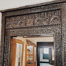
Bird's eye view of Mikindani Bay, Swahili Door in Mtwara and historic
1408:
1679:
805:, christalbella, alexandrite, tourmaline, and rhodolite since 1995.
794:
632:
583:
419:
226:
216:
31:
691:, which is named after the Mbagala River located in Mtwara Region.
823:
749:
1638:
1910:
1642:
1412:
48:
593:
576:
559:
542:
525:
508:
1402:
747:
within the region as one of Ruvuma's many tributaries.
700:
Groundnut scheme during the British colonial occupation
484:
1017:
Hasnain Murji, former member of parliament of Tanzania
1866:
Sanjesi Game Reserve (Nanyumbu & Masasi District)
1036:"Sub-national HDI - Area Database - Global Data Lab"
30:
This article is about the region. For the city, see
1890:
1873:
1851:
1831:
1806:
1785:
1768:
1742:
1686:
1598:
1446:
589:
572:
555:
538:
521:
504:
479:
460:
450:
440:
430:
413:
395:
385:
378:
368:
360:
350:
342:
337:
329:
319:
311:
306:
298:
293:
232:
222:
209:
201:
193:
175:
42:
1297:"Tanzania Whale Network, Mnazi Bay, Mtwara Region"
1863:Lukwika Lumesule Game Reserve (Nanyumbu District)
997:, Member of the UVCCM National Council Tanzanian
704:In 1948, the British Government formulated the "
671:The native peoples of the Mtwara Region are the
1922:
1654:
1424:
1064:
1062:
1060:
8:
715:Mtwara was part of Lindi Region until 1971.
1929:
1915:
1907:
1661:
1647:
1639:
1431:
1417:
1409:
631:, with its capital as the municipality of
39:
848:
1027:
499:
478:
459:
429:
412:
377:
367:
336:
328:
305:
292:
244:
221:
200:
174:
139:
127:
74:
315:16,710 km (6,450 sq mi)
647:. To the west, Mtwara is bordered by
588:
571:
554:
537:
520:
503:
449:
439:
394:
384:
359:
349:
341:
318:
310:
297:
231:
208:
192:
7:
1859:Mnazi Bay-Ruvuma Estuary Marine Park
815:Mnazi Bay-Ruvuma Estuary Marine Park
983:Notable Persons from Mtwara Region
846:, each administered by a council:
809:National Parks and Forest Reserves
299: • Regional Commissioner
25:
1001:2022-2027 (Ambassador of Mtwara)
1589:
870:
180:
129:
104:
93:
82:
1380:from the original on 2021-12-27
1340:from the original on 2021-07-21
1309:from the original on 2022-07-07
1278:from the original on 2021-07-21
1247:from the original on 2021-07-21
1216:from the original on 2021-07-21
1185:from the original on 2022-06-17
1156:from the original on 2021-07-21
1125:from the original on 2022-06-06
1100:from the original on 2021-07-21
1046:from the original on 2018-09-23
687:of Dar es Dalaam especially in
643:to the south is formed by the
1:
1371:National Bureau of Statistics
991:, former Tanzanian president.
813:Mtwara Region is home to the
1852:National Parks and Reserves
852:Districts of Mtwara Region
828:Humpback whale illustration
706:Tanganyika groundnut scheme
496:Symbols of Tanzania
37:Region in Coastal, Tanzania
2039:
333:837 m (2,746 ft)
29:
1952:
1676:
1587:
1119:"Country size comparison"
869:
851:
710:Overseas Food Corporation
655:, and to the east is the
606:
500:
495:
491:
247:Mtwara-Mikindani District
160:10.6417000°S 39.2376000°E
140:
135:Mtwara Region in Tanzania
128:
75:
66:
1897:Nyerere House, Mikindani
833:Administrative divisions
1769:National Historic Sites
1367:Dar es Salaam, Tanzania
1365:(Report) (in Swahili).
1328:"Mtwara Region Profile"
1266:"Mtwara Region Profile"
1235:"Mtwara Region Profile"
1204:"Mtwara Region Profile"
1144:"Mtwara Region Profile"
1088:"Mtwara Region Profile"
165:-10.6417000; 39.2376000
1832:Major Cities and Towns
829:
755:
598:
581:
564:
547:
530:
513:
364:98/km (250/sq mi)
330:Highest elevation
49:
1040:hdi.globaldatalab.org
1008:, Tanzanian musician.
827:
753:
627:'s 31 administrative
597:
580:
563:
550:Dash-and-dot goatfish
546:
529:
512:
252:Masasi Urban District
202:Administrative Region
1600:Zanzibar Archipelago
743:which is fed by the
725:Dar es Salaam Region
533:White-barred emperor
386: • Settler
361: • Density
2023:Regions of Tanzania
1962:Masasi Town Council
1699:Masasi Town Council
1440:Regions of Tanzania
958:Tandahimba District
396: • Native
285:Tandahimba District
156: /
117:From top to bottom:
1891:National Monuments
1874:National Landmarks
1074:2013-05-02 at the
1014:, Tanzanian rapper
830:
756:
729:Kilimanjaro Region
651:, to the north by
599:
582:
565:
548:
531:
514:
343: • Total
312: • Total
27:Region of Tanzania
2005:
2004:
1904:
1903:
1636:
1635:
1448:Mainland Tanzania
980:
979:
938:Nanyumbu District
610:
609:
351: • Rank
320: • Rank
302:Ahmed Abbas Ahmed
275:Nanyumbu District
16:(Redirected from
2030:
1957:Mtwara-Mikindani
1931:
1924:
1917:
1908:
1807:Rivers and Lakes
1798:Nakitumbe Island
1694:Mtwara-Mikindani
1663:
1656:
1649:
1640:
1593:
1433:
1426:
1419:
1410:
1405:
1403:Official website
1389:
1388:
1386:
1385:
1379:
1364:
1355:
1349:
1348:
1346:
1345:
1339:
1332:
1324:
1318:
1317:
1315:
1314:
1308:
1301:
1293:
1287:
1286:
1284:
1283:
1277:
1270:
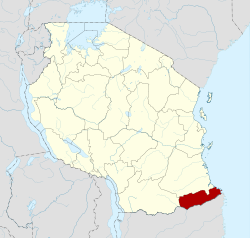
1262:
1256:
1255:
1253:
1252:
1246:
1239:
1231:
1225:
1224:
1222:
1221:
1215:
1208:
1200:
1194:
1193:
1191:
1190:
1171:
1165:
1164:
1162:
1161:
1155:
1148:
1140:
1134:
1133:
1131:
1130:
1115:
1109:
1108:
1106:
1105:
1099:
1092:
1084:
1078:
1066:
1055:
1054:
1052:
1051:
1032:
878:Mtwara Mikindani
874:
849:
487:
485:Official website
471:
186:
184:
183:
171:
170:
168:
167:
166:
161:
157:
154:
153:
152:
149:
133:
108:
97:
86:
61:
60:
52:
40:
21:
18:Mtwara, Tanzania
2038:
2037:
2033:
2032:
2031:
2029:
2028:
2027:
2008:
2007:
2006:
2001:
1948:
1935:
1905:
1900:
1886:
1883:Makonde Plateau
1869:
1847:
1827:
1802:
1781:
1764:
1738:
1682:
1672:
1667:
1637:
1632:
1608:Mjini Magharibi
1594:
1585:
1442:
1437:
1401:
1398:
1393:
1392:
1383:
1381:
1377:
1362:
1357:
1356:
1352:
1343:
1341:
1337:
1330:
1326:
1325:
1321:
1312:
1310:
1306:
1299:
1295:
1294:
1290:
1281:
1279:
1275:
1268:
1264:
1263:
1259:
1250:
1248:
1244:
1237:
1233:
1232:
1228:
1219:
1217:
1213:
1206:
1202:
1201:
1197:
1188:
1186:
1173:
1172:
1168:
1159:
1157:
1153:
1146:
1142:
1141:
1137:
1128:
1126:
1117:
1116:
1112:
1103:
1101:
1097:
1090:
1086:
1085:
1081:
1076:Wayback Machine
1067:
1058:
1049:
1047:
1034:
1033:
1029:
1024:
985:
948:Newala District
928:Mtwara District
918:Masasi District
864:
840:
835:
819:Humpback whales
811:
783:
770:
761:
737:Makonde plateau
721:
702:
697:
685:Temeke District
669:
483:
469:
468:
436:
289:
280:Newala District
265:Masasi District
243:
242:
181:
179:
164:
162:
158:
155:
150:
147:
145:
143:
142:
136:
124:
119:
114:
113:
112:
111:
110:
109:
100:
99:
98:
89:
88:
87:
71:
62:
54:
47:
45:
38:
35:
28:
23:
22:
15:
12:
11:
5:
2036:
2034:
2026:
2025:
2020:
2010:
2009:
2003:
2002:
2000:
1999:
1994:
1989:
1984:
1979:
1974:
1969:
1964:
1959:
1953:
1950:
1949:
1936:
1934:
1933:
1926:
1919:
1911:
1902:
1901:
1899:
1898:
1894:
1892:
1888:
1887:
1885:
1884:
1881:
1877:
1875:
1871:
1870:
1868:
1867:
1864:
1861:
1855:
1853:
1849:
1848:
1846:
1845:
1842:
1839:
1835:
1833:
1829:
1828:
1826:
1825:
1822:
1819:
1816:
1810:
1808:
1804:
1803:
1801:
1800:
1795:
1789:
1787:
1783:
1782:
1780:
1779:
1772:
1770:
1766:
1765:
1763:
1762:
1757:
1752:
1746:
1744:
1743:Native Peoples
1740:
1739:
1737:
1736:
1731:
1726:
1721:
1716:
1711:
1706:
1701:
1696:
1690:
1688:
1684:
1683:
1677:
1674:
1673:
1668:
1666:
1665:
1658:
1651:
1643:
1634:
1633:
1631:
1630:
1625:
1620:
1615:
1610:
1604:
1602:
1596:
1595:
1588:
1586:
1584:
1583:
1578:
1573:
1568:
1563:
1558:
1553:
1548:
1543:
1538:
1533:
1528:
1523:
1518:
1513:
1508:
1503:
1498:
1493:
1488:
1483:
1478:
1473:
1468:
1463:
1458:
1452:
1450:
1444:
1443:
1438:
1436:
1435:
1428:
1421:
1413:
1407:
1406:
1397:
1396:External links
1394:
1391:
1390:
1373:. 2016-04-01.
1350:
1319:
1288:
1257:
1226:
1195:
1166:
1135:
1110:
1079:
1056:
1026:
1025:
1023:
1020:
1019:
1018:
1015:
1009:
999:
998:
992:
989:Benjamin Mkapa
984:
981:
978:
977:
972:
970:
964:
963:
960:
954:
953:
950:
944:
943:
940:
934:
933:
930:
924:
923:
920:
914:
913:
910:
904:
903:
900:
894:
893:
890:
884:
883:
880:
875:
867:
866:
861:
858:
854:
853:
839:
836:
834:
831:
810:
807:
782:
779:
769:
766:
760:
757:
745:Mbangala River
720:
717:
708:" through the
701:
698:
696:
693:
668:
665:
617:Mkoa wa Mtwara
608:
607:
604:
603:
591:
587:
586:
574:
570:
569:
567:Humpback whale
557:
553:
552:
540:
536:
535:
523:
519:
518:
506:
502:
501:
498:
497:
493:
492:
489:
488:
481:
477:
476:
465:
458:
457:
454:
448:
447:
444:
438:
437:
434:
432:
428:
427:
417:
411:
410:
397:
393:
392:
387:
383:
382:
376:
375:
372:
366:
365:
362:
358:
357:
352:
348:
347:
344:
340:
339:
335:
334:
331:
327:
326:
321:
317:
316:
313:
309:
308:
304:
303:
300:
296:
295:
291:
290:
288:
287:
282:
277:
272:
267:
262:
259:
254:
249:
240:
239:
238:
236:
230:
229:
224:
220:
219:
213:
207:
206:
203:
199:
198:
195:
191:
190:
177:
173:
172:
138:
137:
134:
126:
125:
115:
103:
102:
101:
92:
91:
90:
81:
80:
79:
78:
77:
76:
73:
72:
67:
64:
63:
50:Mkoa wa Mtwara
46:
43:
36:
26:
24:
14:
13:
10:
9:
6:
4:
3:
2:
2035:
2024:
2021:
2019:
2018:Mtwara Region
2016:
2015:
2013:
1998:
1995:
1993:
1990:
1988:
1985:
1983:
1980:
1978:
1975:
1973:
1970:
1968:
1967:Nanyamba Town
1965:
1963:
1960:
1958:
1955:
1954:
1951:
1947:
1943:
1942:Mtwara Region
1939:
1932:
1927:
1925:
1920:
1918:
1913:
1912:
1909:
1896:
1895:
1893:
1889:
1882:
1879:
1878:
1876:
1872:
1865:
1862:
1860:
1857:
1856:
1854:
1850:
1843:
1840:
1837:
1836:
1834:
1830:
1823:
1820:
1818:Mbagala River
1817:
1815:
1812:
1811:
1809:
1805:
1799:
1796:
1794:
1791:
1790:
1788:
1784:
1778:Historic Town
1777:
1774:
1773:
1771:
1767:
1761:
1758:
1756:
1753:
1751:
1748:
1747:
1745:
1741:
1735:
1732:
1730:
1727:
1725:
1722:
1720:
1717:
1715:
1712:
1710:
1707:
1705:
1704:Nanyamba Town
1702:
1700:
1697:
1695:
1692:
1691:
1689:
1685:
1681:
1675:
1671:
1670:Mtwara Region
1664:
1659:
1657:
1652:
1650:
1645:
1644:
1641:
1629:
1626:
1624:
1621:
1619:
1616:
1614:
1611:
1609:
1606:
1605:
1603:
1601:
1597:
1592:
1582:
1579:
1577:
1574:
1572:
1569:
1567:
1564:
1562:
1559:
1557:
1554:
1552:
1549:
1547:
1544:
1542:
1539:
1537:
1534:
1532:
1529:
1527:
1524:
1522:
1519:
1517:
1514:
1512:
1509:
1507:
1504:
1502:
1499:
1497:
1494:
1492:
1489:
1487:
1484:
1482:
1479:
1477:
1474:
1472:
1469:
1467:
1464:
1462:
1461:Dar es Salaam
1459:
1457:
1454:
1453:
1451:
1449:
1445:
1441:
1434:
1429:
1427:
1422:
1420:
1415:
1414:
1411:
1404:
1400:
1399:
1395:
1376:
1372:
1368:
1360:
1354:
1351:
1336:
1329:
1323:
1320:
1305:
1298:
1292:
1289:
1274:
1267:
1261:
1258:
1243:
1236:
1230:
1227:
1212:
1205:
1199:
1196:
1184:
1180:
1176:
1175:"Masasi Peak"
1170:
1167:
1152:
1145:
1139:
1136:
1124:
1120:
1114:
1111:
1096:
1089:
1083:
1080:
1077:
1073:
1070:
1065:
1063:
1061:
1057:
1045:
1041:
1037:
1031:
1028:
1021:
1016:
1013:
1010:
1007:
1004:
1003:
1002:
996:
993:
990:
987:
986:
982:
976:
973:
971:
969:
966:
965:
961:
959:
956:
955:
951:
949:
946:
945:
941:
939:
936:
935:
931:
929:
926:
925:
921:
919:
916:
915:
911:
909:
906:
905:
901:
899:
898:Nanyamba Town
896:
895:
891:
889:
886:
885:
881:
879:
876:
873:
868:
862:
859:
856:
855:
850:
847:
845:
837:
832:
826:
822:
820:
816:
808:
806:
804:
799:
796:
792:
787:
780:
778:
774:
767:
765:
758:
752:
748:
746:
742:
738:
734:
730:
726:
718:
716:
713:
711:
707:
699:
694:
692:
690:
686:
682:
678:
674:
666:
664:
660:
658:
654:
650:
649:Ruvuma Region
646:
642:
638:
634:
630:
626:
623:) is one of
622:
618:
614:
613:Mtwara Region
605:
602:
596:
592:
585:
579:
575:
568:
562:
558:
551:
545:
541:
534:
528:
524:
517:
511:
507:
494:
490:
486:
482:
475:
466:
463:
455:
453:
452:ISO 3166 code
445:
443:
433:
425:
421:
418:
416:
409:
405:
401:
398:
391:
388:
381:
380:Ethnic groups
373:
371:
363:
356:
353:
345:
332:
325:
322:
314:
301:
286:
283:
281:
278:
276:
273:
271:
268:
266:
263:
260:
258:
257:Nanyamba Town
255:
253:
250:
248:
245:
237:
235:
228:
225:
218:
214:
212:
204:
196:
189:
178:
169:
151:39°14′15.36″E
148:10°38′30.12″S
141:Coordinates:
132:
123:
118:
107:
96:
85:
70:
65:
58:
51:
44:Mtwara Region
41:
33:
19:
1941:
1880:Ruvuma River
1821:Maombi River
1814:Ruvuma River
1793:Mongo Island
1669:
1628:Unguja South
1623:Unguja North
1525:
1382:. Retrieved
1353:
1342:. Retrieved
1322:
1311:. Retrieved
1291:
1280:. Retrieved
1260:
1249:. Retrieved
1229:
1218:. Retrieved
1198:
1187:. Retrieved
1178:
1169:
1158:. Retrieved
1138:
1127:. Retrieved
1113:
1102:. Retrieved
1082:
1048:. Retrieved
1039:
1030:
1000:
995:sameer murji
974:
967:
841:
812:
800:
788:
784:
775:
771:
762:
741:Ruvuma River
722:
714:
703:
670:
661:
657:Indian Ocean
653:Lindi Region
645:Ruvuma River
616:
612:
611:
516:Gray sunbird
270:Mtwara Rural
215:The port of
116:
1972:Newala Town
1709:Newala Town
1618:Pemba South
1613:Pemba North
1496:Kilimanjaro
908:Newala Town
888:Masasi Town
261:Newala Town
163: /
2012:Categories
1997:Tandahimba
1824:Mbuo River
1734:Tandahimba
1384:2022-07-03
1344:2022-06-17
1313:2022-06-17
1282:2022-06-17
1251:2022-06-17
1220:2022-06-17
1189:2022-06-17
1160:2022-06-17
1129:2022-06-17
1104:2022-06-17
1050:2020-02-26
1022:References
863:Population
667:Population
641:Mozambique
474:22nd of 25
355:20th of 31
338:Population
324:23rd of 31
294:Government
1938:Districts
1844:Mikindani
1776:Mikindani
1687:Districts
1678:Capital:
1556:Shinyanga
1179:peakvisor
1006:Harmonize
975:1,334,606
860:District
844:districts
838:Districts
719:Geography
522:Butterfly
442:Area code
415:Time zone
346:1,634,947
234:Districts
211:Named for
122:Mikindani
1987:Nanyumbu
1946:Tanzania
1724:Nanyumbu
1521:Morogoro
1375:Archived
1335:Archived
1304:Archived
1273:Archived
1242:Archived
1211:Archived
1183:Archived
1151:Archived
1123:Archived
1095:Archived
1072:Archived
1044:Archived
962:238,927
952:122,072
942:158,425
932:132,329
922:273,940
902:107,112
882:113,732
803:sapphire
733:Eswatini
679:and the
625:Tanzania
601:Sapphire
431:Postcode
188:Tanzania
1786:Islands
1750:Makonde
1566:Singida
1506:Manyara
912:93,728
892:94,342
865:(2016)
791:Cassava
781:Economy
768:Geology
759:Climate
695:History
689:Mbagala
673:Makonde
637:Makonde
629:regions
621:Swahili
590:Mineral
480:Website
400:Makonde
390:Swahili
374:Mtwaran
370:Demonym
223:Capital
197:Coastal
176:Country
57:Swahili
1992:Newala
1982:Mtwara
1977:Masasi
1841:Masasi
1838:Mtwara
1729:Newala
1719:Mtwara
1714:Masasi
1680:Mtwara
1576:Tabora
1571:Songwe
1561:Simiyu
1551:Ruvuma
1536:Njombe
1531:Mwanza
1526:Mtwara
1491:Kigoma
1486:Katavi
1481:Kagera
1476:Iringa
1466:Dodoma
1456:Arusha
795:cashew
675:, the
633:Mtwara
584:Cashew
556:Mammal
464:(2018)
406:&
227:Mtwara
217:Mtwara
185:
69:Region
53:
32:Mtwara
1760:Makua
1581:Tanga
1546:Rukwa
1541:Pwani
1516:Mbeya
1501:Lindi
1471:Geita
1378:(PDF)
1363:(PDF)
1338:(PDF)
1331:(PDF)
1307:(PDF)
1300:(PDF)
1276:(PDF)
1269:(PDF)
1245:(PDF)
1238:(PDF)
1214:(PDF)
1207:(PDF)
1154:(PDF)
1147:(PDF)
1098:(PDF)
1091:(PDF)
968:Total
681:Makua
467:0.507
456:TZ-17
435:21xxx
420:UTC+3
408:Makua
1511:Mara
857:Map
727:and
573:Tree
539:Fish
505:Bird
307:Area
241:List
205:1971
194:Zone
1940:of
1755:Yao
1012:A.Y
677:Yao
619:in
470:low
462:HDI
446:023
424:EAT
404:Yao
2014::
1944:,
1369::
1333:.
1302:.
1271:.
1240:.
1209:.
1181:.
1177:.
1149:.
1121:.
1093:.
1059:^
1042:.
1038:.
659:.
472:·
402:,
1930:e
1923:t
1916:v
1662:e
1655:t
1648:v
1432:e
1425:t
1418:v
1387:.
1347:.
1316:.
1285:.
1254:.
1223:.
1192:.
1163:.
1132:.
1107:.
1053:.
615:(
426:)
422:(
59:)
55:(
34:.
20:)
Text is available under the Creative Commons Attribution-ShareAlike License. Additional terms may apply.