89:
569:
663:
147:
78:
1306:
529:
60:
621:
1231:
71:
1396:
344:
96:
132:
1149:
1168:
1141:
1122:
290:
1406:
399:, Southern District. In 1929, the municipal council was replaced by a municipal delegation. By 1954, the mining company "El Boleo" ceased operations, which resulted in many people moving to other parts of the country, but three years later, Fomento Minero decided to take over the company and restarted the copper exploitation work.
330:
is located in the municipality, between the
Pacific Ocean and the Gulf of California. With a landmass of over 24,930 km (9,625 sq mi), it is the largest wildlife refuge in Mexico and borders on the northern edge of the
831:(3,834 hab.), Bahía Tortugas (2,367 hab.), classified as urban; and San Francisco (1,919 hab.), Bahía Asunción (1,453 hab.), Las Margaritas (1,145 hab.), and Estero de la Bocana (1,013 hab.), classified as rural.
824:
403:
was founded in 1957 on the
Pacific Coast to supply the demand of salt in the western United States. When Baja California Sur became a state in 1972, the municipality of Mulegé was formally established.
476:
Agriculture and livestock are principally concentrated in the area of Vizcaíno Valley and employs 36% of the population. There were 2,987.7 ha of crop land in the municipality. The main crops are
388:
Rich copper deposits were discovered in 1868, later developed as mines. In 1872, Eiseman y Valle was incorporated as a business for the exploitation of copper. In 1885, the French mining company
382:
1197:
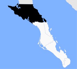
315:. It is the largest municipality by area in Mexico, with an area of 33,092.20 km (12,777 sq mi). In the 2020 Census, it had a population of 64,022 inhabitants.
1467:
1068:
359:
1219:
972:
88:
568:
407:
There is an initiative to split the municipality into two, with the division along the ridge dividing the current municipality. The
Pacific side, with
1295:
107:
1375:
1351:
1184:
146:
374:
111:
1344:
1316:
1033:
816:
637:
557:
434:
323:
182:
44:
1423:
411:
and Villa
Alberto Andrés Alvarado Arámburo would be separated from the Gulf of California side, which includes Santa Rosalía and Mulegé.
378:
115:
1061:
914:
679:
1212:
377:
in the area locally known as Caaman
Cagaleja, which means "river between two rocks." Other important Jesuit missions in Mulegé were
1290:
633:
454:
327:
1462:
1275:
549:
628:
The tourism sector has been growing in the last years. The municipality is home of two jesuit missions of the XVII century in
867:
201:
662:
1409:
951:
1270:
1054:
1399:
1205:
370:
1380:
1356:
1265:
1245:
640:
it's another spot, famous for being an historical mining town and their many buildings in french architectural style.
415:
263:
1105:
659:
during the months of
December to April. Mulegé also has many popular beaches, many of which are nearby Mulegé town.
576:
The fishing sector employs 10.6 % of the population. There were 19,329 tons of fish products in 2021, of which
933:
Baja
California Sur - Los Cabos - Cabo San Lucas - Loreto - La Paz: Guía de viaje del Estado de Baja California Sur
392:
began its operations and built the town of Santa Rosalía; the first copper smelting furnace was installed in 1886.
351:
1285:
835:
396:
301:
355:
1327:
1260:
1177:
675:
77:
1363:
1332:
414:
As of March 1, 2021, the municipality reported 1,188 recoveries, 46 active cases, and 109 deaths from the
131:
1095:
528:
59:
1305:
815:
The municipality has 381 localities, the largest of which (with 2020 populations in parentheses) were:
1368:
273:
1236:
1230:
620:
385:. In 1768, the Franciscans took over responsibility for colonial Baja California from the Jesuits.
332:
312:
195:
172:
1156:
847:
652:
119:
439:
70:
468:
There are four main economic sectors in Mulegé: agriculture, mining, livestock and tourism.
308:
167:
911:
1280:
1109:
1099:
918:
1046:
843:
820:
656:
644:
541:
444:
426:
Including the municipal seat of Santa Rosalía, the municipality is subdivided into six
408:
400:
316:
260:
1456:
1132:
1089:
678:, although many of them requires trips by mule of 3-5 days. There are minor sites at
481:
17:
891:
493:
343:
95:
994:"Coronavirus – Baja California Sur Situation Report – Información de Coronavirus"
648:
636:, these two towns also have oasis, which are a popular sightview in the desert.
373:
in 1705. Three years later, the Jesuit missionary Juan de Basaldúa founded the
1438:
1425:
674:
sites in Baja
California Sur and Mexico. The best known sites are located at
280:
256:
605:
589:
489:
363:
251:
973:"Proposal to split Mulegé in two municipalities sent to the State Congress"
828:
683:
629:
449:
993:
289:
671:
609:
581:
477:
389:
580:
represented more than 62 % of the captures. Other products include
839:
601:
597:
593:
545:
585:
553:
501:
485:
305:
160:
354:
was the first explorer to navigate the coastline of Mulegé, whereas
661:
619:
567:
527:
513:
509:
342:
288:
708:
577:
537:
517:
505:
497:
1201:
1050:
560:(11 thousand tons), and employs 21.6 % of the population.
395:
The municipality was first incorporated in 1916 as part of the
1304:
703:
536:
The mining sector is concentrated around the production of
369:
The first
Spanish missionary to visit the area was Father
27:
Municipality in the
Mexican state of Baja California Sur
1029:
1027:
1025:
1023:
1021:
1019:
1017:
1015:
516:(11 tons). There is also a significant production of
834:
Mulegé is crossed by the Carretera Transpeninsular (
1315:
1253:
270:
250:
242:
234:
226:
221:
213:
208:
193:
188:
178:
166:
156:
35:
870:(in Spanish). Unidad de Microrregiones, SEDESOL
1213:
1062:
1000:(in Spanish). Gobierno de Baja California Sur
931:Jiménez González, Victor Manuel (July 2015).
892:"Censo de Población y Vivienda 2020 - SCITEL"
500:. The meat production comes principally from
217:33,092.20 km (12,776.97 sq mi)
8:
886:
884:
694:
30:Municipality in Baja California Sur, Mexico
1220:
1206:
1198:
1069:
1055:
1047:
693:
358:explored the inlands in 1596 on behalf of
151:Location of Mulegé in Baja California Sur.
32:
946:
944:
942:
846:. Regional flights are available at the
859:
249:
220:
207:
187:
155:
143:
125:
50:
1077:Places adjacent to Mulegé Municipality
825:Villa Alberto Andrés Alvarado Arámburo
1468:Municipalities of Baja California Sur
670:Mulegé also contains the most famous
269:
241:
233:
225:
212:
192:
177:
165:
7:
1405:
1084:
624:Whale watching at San Ignacio Lagoon
179:Municipal seat and largest city
596:. There also processing centers of
335:Protected Area of Flora and Fauna.
25:
532:Salt production in Guerrero Negro
322:The municipal seat is located in
1404:
1395:
1394:
1229:
1166:
1147:
1139:
1120:
145:
130:
94:
87:
76:
69:
58:
690:Demographics and Transportation
686:, which can be reached by car.
666:Cave paintings at El Ratón Cave
375:Santa Rosalía de Mulegé mission
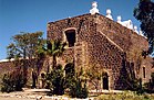
112:Mission Santa Rosalía de Mulegé
116:Mission San Ignacio Kadakaamán
1:
1167:
1121:
868:"Mulegé, General Information"
572:Fishing boats at Mulegé beach
328:El Vizcaíno Biosphere Reserve
319:is part of the municipality.
200:Edith Aguilar Villavicencio (
1148:
1140:
108:San Francisco Cave Paintings
643:Ecotourism revolves around
416:COVID-19 pandemic in Mexico
1484:
975:(in Spanish). BCS Noticias
1390:
1302:
1243:
1082:
836:Mexican Federal Highway 1
721:—
472:Agriculture and livestock
397:Baja California Territory
371:Juan María de Salvatierra
144:
126:
51:
42:
1106:San Quintín Municipality
118:; Bottom: Mulegé Oasis,
1034:2020 Mulegé Estratégico
921:. Retrieved 01-03-2015.
676:Sierra de San Francisco
352:Juan Rodríguez Cabrillo
238:1.9/km (5.0/sq mi)
1309:
998:coronavirus.bcs.gob.mx
917:March 4, 2016, at the
667:
625:
573:
552:(1.3 million ton) and
533:
348:
294:
1308:
1096:Ensenada Municipality
912:ANP 282 - El Vizcaíno
695:Historical population
665:
623:
571:
531:
520:from goats and cows.
346:
292:
272: • Summer (
18:Mulegé (municipality)
1178:Comondú Municipality
954:(in Spanish). INAFED
544:(4.8 million tons),
300:is the northernmost
235: • Density
1463:Mulegé Municipality
1435: /
1333:Ciudad Constitución
1237:Baja California Sur
1185:Loreto Municipality
1145:Mulegé Municipality
952:"History of Mulegé"
894:(in Spanish). INEGI
838:), which runs from
696:
680:Sierra de Guadalupe
347:San Ignacio Mission
333:Valle de los Cirios
313:Baja California Sur
173:Baja California Sur
1439:27.250°N 113.250°W
1317:Municipalities and
1310:
1157:Gulf of California
850:in Santa Rosalía.
848:Palo Verde Airport
668:
653:San Ignacio Lagoon
626:
574:
534:
356:Sebastián Vizcaíno
349:
295:
227: • Total
214: • Total
120:San Ignacio Lagoon
1418:
1417:
1369:San José del Cabo
1195:
1194:
1190:
1189:
813:
812:
550:San Marcos Island
287:
286:
243: • Seat
16:(Redirected from
1475:
1450:
1449:
1447:
1446:
1445:
1444:27.250; -113.250
1440:
1436:
1433:
1432:
1431:
1428:
1408:
1407:
1398:
1397:
1234:
1233:
1222:
1215:
1208:
1199:
1170:
1169:
1151:
1150:
1143:
1142:
1124:
1123:
1085:
1071:
1064:
1057:
1048:
1036:
1031:
1010:
1009:
1007:
1005:
990:
984:
983:
981:
980:
969:
963:
962:
960:
959:
948:
937:
936:
928:
922:
909:
903:
902:
900:
899:
888:
879:
878:
876:
875:
864:
710:
705:
697:
512:(14.9 tons) and
360:Gaspar de Zúñiga
277:
149:
134:
110: ; Middle:
98:
91:
80:
73:
62:
33:
21:
1483:
1482:
1478:
1477:
1476:
1474:
1473:
1472:
1453:
1452:
1443:
1441:
1437:
1434:
1429:
1426:
1424:
1422:
1421:
1419:
1414:
1386:
1319:municipal seats
1318:
1311:
1300:
1291:South Territory
1281:The Californias
1249:
1239:
1228:
1226:
1196:
1191:
1152:
1110:Baja California
1100:Baja California
1093:
1078:
1075:
1045:
1040:
1039:
1032:
1013:
1003:
1001:
992:
991:
987:
978:
976:
971:
970:
966:
957:
955:
950:
949:
940:
930:
929:
925:
919:Wayback Machine
910:
906:
897:
895:
890:
889:
882:
873:
871:
866:
865:
861:
856:
827:(10,897 hab.),
823:(13,596 hab.),
819:(14,357 hab.),
692:
618:
566:
526:
474:
466:
424:
341:
271:
152:
140:
139:
138:
137:
122:
104:
103:
102:
101:
100:
99:
92:
83:
82:
81:
74:
65:
64:
63:
47:
38:
31:
28:
23:
22:
15:
12:
11:
5:
1481:
1479:
1471:
1470:
1465:
1455:
1454:
1416:
1415:
1413:
1412:
1402:
1391:
1388:
1387:
1385:
1384:
1372:
1360:
1348:
1336:
1323:
1321:
1313:
1312:
1303:
1301:
1299:
1298:
1293:
1288:
1283:
1278:
1273:
1268:
1263:
1257:
1255:
1251:
1250:
1244:
1241:
1240:
1227:
1225:
1224:
1217:
1210:
1202:
1193:
1192:
1188:
1187:
1182:
1180:
1174:
1173:
1171:
1164:
1161:
1160:
1153:
1138:
1136:
1128:
1127:
1125:
1118:
1115:
1114:
1112:
1103:
1083:
1080:
1079:
1076:
1074:
1073:
1066:
1059:
1051:
1044:
1043:External links
1041:
1038:
1037:
1011:
985:
964:
938:
923:
904:
880:
858:
857:
855:
852:
844:Cabo San Lucas
821:Guerrero Negro
811:
810:
807:
804:
800:
799:
796:
793:
789:
788:
785:
782:
778:
777:
774:
771:
767:
766:
763:
760:
756:
755:
752:
749:
745:
744:
741:
738:
734:
733:
730:
727:
723:
722:
719:
716:
712:
711:
706:
701:
691:
688:
657:Guerrero Negro
645:whale watching
617:
614:
565:
562:
542:Guerrero Negro
525:
522:
508:(117.6 tons),
504:(697.8 tons),
473:
470:
465:
462:
461:
460:
457:
452:
447:
445:Guerrero Negro
442:
440:Bahía Tortugas
437:
423:
420:
409:Guerrero Negro
401:Guerrero Negro
340:
337:
317:Isla Natividad
285:
284:
278:
268:
267:
254:
248:
247:
244:
240:
239:
236:
232:
231:
228:
224:
223:
219:
218:
215:
211:
210:
206:
205:
198:
191:
190:
186:
185:
180:
176:
175:
170:
164:
163:
158:
154:
153:
150:
142:
141:
135:
129:
128:
127:
124:
123:
105:
93:
86:
85:
84:
75:
68:
67:
66:
57:
56:
55:
54:
53:
52:
49:
48:
43:
40:
39:
36:
29:
26:
24:
14:
13:
10:
9:
6:
4:
3:
2:
1480:
1469:
1466:
1464:
1461:
1460:
1458:
1451:
1448:
1411:
1403:
1401:
1393:
1392:
1389:
1382:
1378:
1377:
1373:
1370:
1366:
1365:
1361:
1358:
1354:
1353:
1349:
1346:
1345:Santa Rosalía
1342:
1341:
1337:
1334:
1330:
1329:
1325:
1324:
1322:
1320:
1314:
1307:
1297:
1294:
1292:
1289:
1287:
1284:
1282:
1279:
1277:
1274:
1272:
1269:
1267:
1264:
1262:
1259:
1258:
1256:
1252:
1247:
1242:
1238:
1232:
1223:
1218:
1216:
1211:
1209:
1204:
1203:
1200:
1186:
1183:
1181:
1179:
1176:
1175:
1172:
1165:
1163:
1162:
1159:
1158:
1154:
1146:
1137:
1135:
1134:
1133:Pacific Ocean
1130:
1129:
1126:
1119:
1117:
1116:
1113:
1111:
1107:
1104:
1101:
1097:
1092:
1091:
1090:Pacific Ocean
1087:
1086:
1081:
1072:
1067:
1065:
1060:
1058:
1053:
1052:
1049:
1042:
1035:
1030:
1028:
1026:
1024:
1022:
1020:
1018:
1016:
1012:
999:
995:
989:
986:
974:
968:
965:
953:
947:
945:
943:
939:
934:
927:
924:
920:
916:
913:
908:
905:
893:
887:
885:
881:
869:
863:
860:
853:
851:
849:
845:
841:
837:
832:
830:
826:
822:
818:
817:Santa Rosalía
808:
805:
802:
801:
797:
794:
791:
790:
786:
783:
780:
779:
775:
772:
769:
768:
764:
761:
758:
757:
753:
750:
747:
746:
742:
739:
736:
735:
731:
728:
725:
724:
720:
717:
714:
713:
707:
702:
699:
698:
689:
687:
685:
681:
677:
673:
664:
660:
658:
654:
650:
646:
641:
639:
638:Santa Rosalía
635:
631:
622:
615:
613:
611:
607:
603:
599:
595:
591:
587:
583:
579:
570:
563:
561:
559:
558:Santa Rosalía
555:
551:
547:
543:
539:
530:
523:
521:
519:
515:
511:
507:
503:
499:
495:
491:
487:
483:
482:chili peppers
479:
471:
469:
463:
458:
456:
453:
451:
448:
446:
443:
441:
438:
436:
435:Santa Rosalía
433:
432:
431:
429:
421:
419:
417:
412:
410:
405:
402:
398:
393:
391:
386:
384:
380:
376:
372:
367:
365:
362:, viceroy of
361:
357:
353:
345:
338:
336:
334:
329:
325:
324:Santa Rosalía
320:
318:
314:
310:
307:
303:
299:
291:
282:
279:
275:
265:
264:(US Mountain)
262:
258:
255:
253:
245:
237:
229:
216:
203:
199:
197:
194: •
184:
183:Santa Rosalía
181:
174:
171:
169:
162:
159:
148:
133:
121:
117:
113:
109:
97:
90:
79:
72:
61:
46:
41:
34:
19:
1420:
1374:
1362:
1350:
1339:
1338:
1326:
1155:
1144:
1131:
1088:
1002:. Retrieved
997:
988:
977:. Retrieved
967:
956:. Retrieved
932:
926:
907:
896:. Retrieved
872:. Retrieved
862:
833:
814:
669:
642:
627:
575:
535:
494:strawberries
475:
467:
428:delegaciones
427:
425:
422:Subdivisions
413:
406:
394:
387:
368:
350:
321:
302:municipality
297:
296:
293:Mulegé oasis
136:Coat of arms
45:Municipality
1442: /
649:gray whales
634:San Ignacio
455:San Ignacio
379:San Ignacio
1457:Categories
979:2021-02-10
958:2021-02-10
898:2021-01-27
874:2021-02-10
854:References
222:Population
189:Government
1364:Los Cabos
1296:Volcanoes
1286:Territory
1276:Governors
1271:Etymology
1248:(capital)
1235:State of
682:, nearby
590:shellfish
490:cucumbers
383:Guadalupe
364:New Spain
283:(Pacific)
252:Time zone
1430:113°15′W
1400:Category
1004:March 1,
915:Archived
672:rock art
610:mackerel
582:lobsters
478:tomatoes
459:Vizcaíno
390:El Boleo
1427:27°15′N
1410:Commons
1328:Comondú
840:Tijuana
616:Tourism
602:abalone
598:lobster
594:octopus
564:Fishing
546:plaster
464:Economy
339:History
306:Mexican
304:of the
261:Pacific
157:Country
1381:Loreto
1376:Loreto
1357:La Paz
1352:La Paz
1340:Mulegé
1261:Anthem
1254:Topics
1246:La Paz
829:Mulegé
806:64,022
795:60,171
787:+12.1%
784:59,114
776:+14.7%
773:52,743
762:45,989
754:+19.3%
751:45,963
743:+42.8%
740:38,528
732:+39.0%
729:26,983
718:19,416
684:Mulegé
630:Mulegé
586:sharks
554:copper
524:Mining
502:cattle
486:onions
450:Mulegé
326:. The
298:Mulegé
246:14,357
230:64,022
161:Mexico
37:Mulegé
809:+6.4%
803:2020
798:+1.8%
792:2015
781:2010
770:2005
765:+0.1%
759:2000
748:1995
737:1990
726:1980
715:1970
606:snail
514:sheep
510:goats
309:state
281:UTC−6
257:UTC−7
196:Mayor
168:State
106:Top:
1266:Seal
1006:2021
704:Pop.
700:Year
655:and
632:and
608:and
592:and
578:fish
538:salt
518:milk
506:pigs
498:figs
496:and
381:and
209:Area
842:to
651:at
647:of
556:in
548:in
540:in
311:of
274:DST
202:PAN
1459::
1108:,
1098:,
1014:^
996:.
941:^
883:^
709:±%
612:.
604:,
600:,
588:,
584:,
492:,
488:,
484:,
480:,
430::
418:.
366:.
114:,
1383:)
1379:(
1371:)
1367:(
1359:)
1355:(
1347:)
1343:(
1335:)
1331:(
1221:e
1214:t
1207:v
1102:)
1094:(
1070:e
1063:t
1056:v
1008:.
982:.
961:.
935:.
901:.
877:.
276:)
266:)
259:(
204:)
20:)
Text is available under the Creative Commons Attribution-ShareAlike License. Additional terms may apply.