20:
65:
The use of SBASs, such as MSAS, enables an individual GPS receiver to correct its own position, offering a much greater accuracy. Typically GPS signal accuracy is improved from some 20 meters to approximately 1.5–2 meters in both the horizontal and vertical dimensions.
55:
305:
458:
130:
484:
433:
402:
126:
520:
515:
418:
353:
298:
274:
200:
443:
291:
142:
103:
86:
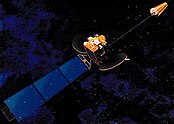
39:
407:
169:
423:
338:
453:
438:
148:
122:
448:
214:
59:
43:
54:
system by reporting (then improving) on the reliability and accuracy of those signals. MSAS is operated by Japan's
348:
62:(JCAB). Tests have been accomplished successfully, MSAS for aviation use was commissioned on 27 September 2007.
333:
271:
250:
232:
314:
384:
374:
474:
394:
194:
47:
278:
509:
479:
176:
283:
218:
412:
379:
489:
343:
369:
328:
19:
494:
18:
287:
51:
467:
393:
362:
321:
131:System for Differential Corrections and Monitoring
485:United Kingdom Global Navigation Satellite System
127:European Geostationary Navigation Overlay Service
56:Ministry of Land, Infrastructure and Transport
28:Multi-functional Satellite Augmentation System
299:
8:
16:Japanese satellite based augmentation system
306:
292:
284:
68:
161:
251:"NASA - NSSDCA - Spacecraft - Details"
233:"NASA - NSSDCA - Spacecraft - Details"
199:: CS1 maint: archived copy as title (
192:
272:Information on WAAS, EGNOS & MSAS
7:
521:Satellite-based augmentation systems
143:Multi-Functional Transport Satellite
516:Navigation satellite constellations
121:MSAS provides a similar service to
40:satellite based augmentation system
14:
215:"Wide Area Augmentation System"
1:
149:Quasi-Zenith Satellite System
123:Wide Area Augmentation System
72:Satellite Name & Details
315:Satellite navigation systems
23:Artist’s rendering of MSAT-1
44:satellite navigation system
537:
125:(WAAS) in North America,
50:(DGPS) to supplement the
129:(EGNOS) in Europe and
24:
60:Civil Aviation Bureau
22:
109:NMEA #50 / PRN #137
92:NMEA #42 / PRN #129
255:nssdc.gsfc.nasa.gov
237:nssdc.gsfc.nasa.gov
475:GNSS reflectometry
277:2021-02-11 at the
133:(SDCM) in Russia.
25:
503:
502:
395:GNSS augmentation
221:on June 12, 2007.
119:
118:
115:18 February 2006
98:26 February 2005
528:
439:QZSS / Michibiki
308:
301:
294:
285:
259:
258:
247:
241:
240:
229:
223:
222:
217:. Archived from
211:
205:
204:
198:
190:
188:
187:
181:
175:. Archived from
174:
166:
69:
48:differential GPS
38:) is a Japanese
536:
535:
531:
530:
529:
527:
526:
525:
506:
505:
504:
499:
463:
389:
358:
317:
312:
279:Wayback Machine
268:
263:
262:
249:
248:
244:
231:
230:
226:
213:
212:
208:
191:
185:
183:
179:
172:
170:"Archived copy"
168:
167:
163:
158:
139:
46:which supports
42:(SBAS), i.e. a
17:
12:
11:
5:
534:
532:
524:
523:
518:
508:
507:
501:
500:
498:
497:
492:
487:
482:
477:
471:
469:
468:Related topics
465:
464:
462:
461:
456:
451:
446:
441:
436:
431:
426:
421:
416:
410:
405:
399:
397:
391:
390:
388:
387:
382:
377:
372:
370:BDS / BeiDou-1
366:
364:
360:
359:
357:
356:
351:
346:
341:
336:
331:
325:
323:
319:
318:
313:
311:
310:
303:
296:
288:
282:
281:
267:
266:External links
264:
261:
260:
242:
224:
206:
160:
159:
157:
154:
153:
152:
146:
138:
135:
117:
116:
113:
110:
107:
100:
99:
96:
93:
90:
83:
82:
79:
76:
73:
15:
13:
10:
9:
6:
4:
3:
2:
533:
522:
519:
517:
514:
513:
511:
496:
493:
491:
488:
486:
483:
481:
480:Kalman filter
478:
476:
473:
472:
470:
466:
460:
457:
455:
452:
450:
447:
445:
442:
440:
437:
435:
432:
430:
427:
425:
422:
420:
417:
414:
411:
409:
406:
404:
401:
400:
398:
396:
392:
386:
383:
381:
378:
376:
373:
371:
368:
367:
365:
361:
355:
354:IRNSS / NAVIC
352:
350:
349:GPS / NavStar
347:
345:
342:
340:
337:
335:
332:
330:
327:
326:
324:
320:
316:
309:
304:
302:
297:
295:
290:
289:
286:
280:
276:
273:
270:
269:
265:
256:
252:
246:
243:
238:
234:
228:
225:
220:
216:
210:
207:
202:
196:
182:on 2015-11-06
178:
171:
165:
162:
155:
150:
147:
144:
141:
140:
136:
134:
132:
128:
124:
114:
111:
108:
106:(Himawari 7)
105:
102:
101:
97:
94:
91:
89:(Himawari 6)
88:
85:
84:
80:
77:
74:
71:
70:
67:
63:
61:
57:
53:
49:
45:
41:
37:
33:
29:
21:
428:
254:
245:
236:
227:
219:the original
209:
184:. Retrieved
177:the original
164:
120:
64:
35:
31:
27:
26:
322:Operational
75:NMEA / PRN
510:Categories
363:Historical
186:2015-05-10
156:References
415:(retired)
81:Launched
78:Location
449:StarFire
444:SouthPAN
380:Timation
275:Archived
195:cite web
137:See also
87:MTSAT-1R
490:Wavelet
385:Tsiklon
375:Transit
344:GLONASS
339:Galileo
145:(MTSAT)
104:MTSAT-2
329:BeiDou
151:(QZSS)
112:145°E
95:140°E
495:RINEX
434:NTRIP
419:JPALS
413:GPS·C
408:GAGAN
403:EGNOS
334:DORIS
180:(PDF)
173:(PDF)
32:MTSAT
459:SDCM
454:WAAS
429:MSAS
424:LAAS
201:link
58:and
36:MSAS
52:GPS
34:or
512::
253:.
235:.
197:}}
193:{{
307:e
300:t
293:v
257:.
239:.
203:)
189:.
30:(
Text is available under the Creative Commons Attribution-ShareAlike License. Additional terms may apply.