674:
44:
714:
729:
696:
983:
123:
863:
584:
673:
393:
of the system, with an average height of 500 metres (1,600 ft), is relatively smooth compared with other
Iberian ranges. It is however very complex, having no defined structural alignment owing to the heavy
917:
1012:
1007:
876:
83:
910:
43:
167:
926:
903:
867:
1017:
766:
713:
144:
491:, the highest point of the whole system. These ranges reach into the provinces of León and Zamora, hence the alternative name
728:
695:
942:
160:
76:
890:
354:
Portuguese region, so that it is considered as a whole under the name 'Galicia-Trás-os-Montes Zone'. It is composed of
401:
Generally the system includes mountains that are rounded in shape, often topped by small rocky outcrops, as well as
426:
351:
528:
1002:
468:
826:
Assessing the impact of wind farms on the plant diversity of blanket bogs in the
Xistral Mountains (NW Spain)
641:
549:
611:
298:
808:
873:
601:
937:
756:
751:
683:
631:
626:
457:
383:
656:
646:
621:
596:
516:
735:
651:
616:
538:
500:
290:
216:
153:
836:
532:
982:
761:
571:
520:
487:
The southwestern ranges; the highest elevations are found in this sector, including 2,047 m high
343:
228:
972:
559:, are generally of a much lesser height and are separated from the Galician Dorsal Range by the
636:
606:
556:
548:
running in a north–south direction separates it from the southwestern ranges. It includes the
464:
274:
785:
Silurian graptolite biostratigraphy of the
Galicia - Tras-os-Montes Zone (Spain and Portugal)
952:
588:
504:
456:
in the
Galician mountains. Many of the species found in the mountains were used in Galician
363:
321:
305:
286:
258:
209:
544:
The
Galician Dorsal Range; with 1,778 m high Cabeza de Manzaneda, its highest elevation. A
967:
880:
560:
524:
431:
406:
402:
395:
282:
278:
149:
885:
947:
679:
545:
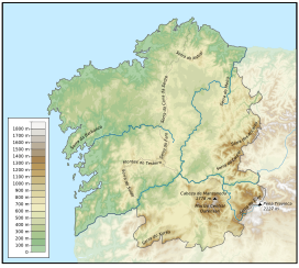
496:
379:
347:
270:
996:
962:
687:
488:
480:
437:
294:
453:
452:
The vegetation is quite homogeneous throughout the massif and there is great plant
705:
825:
418:
847:
701:
512:
17:
182:
169:
98:
85:
784:
442:
355:
308:
the forests of the
Galician System are said to be inhabited by a variety of
221:
895:
350:, the inner Iberian plateau and has great affinity with the geology of the
862:
122:
957:
720:
564:
59:
583:
390:
359:
313:
241:
204:
446:
375:
367:
325:
237:
233:
66:
479:
From the southeast to the northwest the
Galician Massif has three
371:
329:
317:
309:
137:
568:
422:
899:
297:
at 2,127 metres (6,978 ft) . Another important peak is
346:
the
Galician Massif is a northwestern prolongation of the
281:
with its southeastern end reaching into the provinces of
227:
215:
203:
198:
159:
143:
133:
114:
75:
65:
55:
50:
29:
837:Medicinal Use of Some Plants in Galicia (NW Spain)
874:Macizo Galaico (Chain) - Hiking Geographic Card
425:texture and are covered in dense vegetation of
378:in the center and west, which were subject to
911:
8:
441:oaks predominate. The woods alternate with
918:
904:
896:
26:
582:
886:Physical geography and geology of Spain
848:Os Ancares UNESCO-MAB Biosphere Reserve
777:
669:
417:Since rain is abundant in Galicia, the
409:, roughly aligned in a N-S direction.
7:
799:. Geological Society of London, 2003
503:, also known as Serra da Segundera (
1013:Mountain ranges of Castile and León
1008:Mountain ranges of Galicia (Spain)
382:. Its eastern end merges with the
273:in the northwestern corner of the
25:
795:Wes Gibbons & Teresa Moreno,
682:formation in Campodola-Leixazos,
398:that has fragmented the terrain.
981:
861:
767:Geology of the Iberian Peninsula
727:
712:
694:
672:
421:areas of the massif have a soft
121:
42:
943:Cordilleras Costeras Catalanas
1:
555:The coastal ranges; such as
529:San Martín de Castañeda Lake
499:, which are apparent in the
71:2,124 m (6,969 ft)
809:CSIC List of Iberian flora
1034:
427:temperate deciduous forest
306:traditional local folklore
127:Topographic map of Galicia
979:
933:
119:
41:
34:
927:Mountain ranges of Spain
663:Main ranges and features
495:, and show scars of the
469:UNESCO Biosphere Reserve
1018:Physiographic provinces
642:Central Ourensan Massif
550:Central Ourensan Massif
483:longitudinal sections:
293:. Its highest point is
255:Galician-Leonese Massif
612:Serra da Cova da Serpe
592:
508:
262:
145:Autonomous Communities
938:Cordillera Cantábrica
868:Macizo Galaico-Leonés
586:
493:Macizo Galaico-Leonés
267:Macizo Galaico-Leonés
37:Macizo Galaico-Leonés
870:at Wikimedia Commons
797:The geology of Spain
757:Geography of Galicia
752:Cantabrian Mountains
719:Mountain peaks near
591:seen from N-541 road
587:Paraño Mountains in
539:moraine-dammed lakes
458:traditional medicine
384:Cantabrian Mountains
99:42.24250°N 6.79583°W
299:Cabeza de Manzaneda
277:. It is located in
179: /
95: /
879:2014-07-14 at the
762:Geography of Spain
593:
572:intermontane basin
344:Geomorphologically
104:42.24250; -6.79583
51:Highest point
990:
989:
891:Virtual Cadastral
866:Media related to
637:Serra dos Ancares
607:Serra da Barbanza
557:Serra da Barbanza
534:Laguna de Lacillo
465:Serra dos Ancares
445:and wide natural
364:metamorphic rocks
275:Iberian Peninsula
269:) is a system of
247:
246:
161:Range coordinates
16:(Redirected from
1025:
985:
953:Montes de Toledo
920:
913:
906:
897:
865:
850:
845:
839:
834:
828:
823:
817:
816:
806:
800:
793:
787:
782:
731:
716:
698:
676:
602:Serra de Xistral
589:Ourense Province
509:Sierra Segundera
291:Castile and León
265:, also known as
210:Variscan orogeny
194:
193:
191:
190:
189:
184:
183:42.500°N 8.100°W
180:
177:
176:
175:
172:
154:Castile and León
125:
110:
109:
107:
106:
105:
100:
96:
93:
92:
91:
88:
46:
27:
21:
1033:
1032:
1028:
1027:
1026:
1024:
1023:
1022:
1003:Galician Massif
993:
992:
991:
986:
977:
973:Sistema Ibérico
968:Sistema Central
929:
924:
881:Wayback Machine
858:
853:
846:
842:
835:
831:
824:
820:
814:
807:
803:
794:
790:
783:
779:
775:
748:
743:
742:
741:
738:
732:
723:
717:
708:
699:
690:
684:Serra do Courel
677:
665:
632:Serra do Courel
627:Galiñeiro Range
581:
525:glacial valleys
477:
475:Mountain ranges
467:was declared a
432:Quercus petraea
415:
396:fluvial erosion
341:
271:mountain ranges
251:Galician Massif
187:
185:
181:
178:
173:
170:
168:
166:
165:
129:
128:
103:
101:
97:
94:
89:
86:
84:
82:
81:
36:
30:Galician Massif
23:
22:
15:
12:
11:
5:
1031:
1029:
1021:
1020:
1015:
1010:
1005:
995:
994:
988:
987:
980:
978:
976:
975:
970:
965:
963:Sistema Bético
960:
955:
950:
948:Macizo Galaico
945:
940:
934:
931:
930:
925:
923:
922:
915:
908:
900:
894:
893:
888:
883:
871:
857:
856:External links
854:
852:
851:
840:
829:
818:
801:
788:
776:
774:
771:
770:
769:
764:
759:
754:
747:
744:
740:
739:
733:
726:
724:
718:
711:
709:
700:
693:
691:
678:
671:
668:
667:
666:
664:
661:
660:
659:
657:Serra do Xurés
654:
649:
647:Serra do Suído
644:
639:
634:
629:
624:
622:Testeiro Range
619:
614:
609:
604:
599:
597:Serra de Meira
580:
579:List of ranges
577:
576:
575:
553:
546:tectonic basin
542:
497:glacial period
476:
473:
414:
411:
380:Alpine folding
352:Tras os Montes
348:Meseta Central
340:
337:
263:Macizo Galaico
245:
244:
231:
225:
224:
219:
213:
212:
207:
201:
200:
196:
195:
188:42.500; -8.100
163:
157:
156:
147:
141:
140:
135:
131:
130:
126:
120:
117:
116:
112:
111:
79:
73:
72:
69:
63:
62:
57:
53:
52:
48:
47:
39:
38:
35:Macizo Galaico
32:
31:
24:
18:Macizo Galaico
14:
13:
10:
9:
6:
4:
3:
2:
1030:
1019:
1016:
1014:
1011:
1009:
1006:
1004:
1001:
1000:
998:
984:
974:
971:
969:
966:
964:
961:
959:
956:
954:
951:
949:
946:
944:
941:
939:
936:
935:
932:
928:
921:
916:
914:
909:
907:
902:
901:
898:
892:
889:
887:
884:
882:
878:
875:
872:
869:
864:
860:
859:
855:
849:
844:
841:
838:
833:
830:
827:
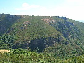
822:
819:
813:
812:
805:
802:
798:
792:
789:
786:
781:
778:
772:
768:
765:
763:
760:
758:
755:
753:
750:
749:
745:
737:
736:Serra do Faro
730:
725:
722:
715:
710:
707:
703:
697:
692:
689:
688:Lugo Province
685:
681:
675:
670:
662:
658:
655:
653:
652:Serra do Eixe
650:
648:
645:
643:
640:
638:
635:
633:
630:
628:
625:
623:
620:
618:
617:Serra do Faro
615:
613:
610:
608:
605:
603:
600:
598:
595:
594:
590:
585:
578:
573:
570:
566:
562:
558:
554:
551:
547:
543:
540:
536:
535:
530:
526:
522:
518:
514:
510:
506:
502:
501:Serra do Eixe
498:
494:
490:
489:Pena Trevinca
486:
485:
484:
482:
481:physiographic
474:
472:
470:
466:
461:
459:
455:
450:
448:
444:
440:
439:
438:Quercus robur
434:
433:
428:
424:
420:
412:
410:
408:
405:, basins and
404:
399:
397:
392:
387:
385:
381:
377:
373:
369:
365:
361:
357:
353:
349:
345:
338:
336:
334:
331:
327:
323:
322:Santa Compaña
319:
315:
311:
307:
302:
300:
296:
295:Pena Trevinca
292:
288:
284:
280:
276:
272:
268:
264:
260:
256:
252:
243:
239:
235:
232:
230:
226:
223:
220:
218:
214:
211:
208:
206:
202:
197:
192:
164:
162:
158:
155:
151:
148:
146:
142:
139:
136:
132:
124:
118:
113:
108:
80:
78:
74:
70:
68:
64:
61:
60:Peña Trevinca
58:
54:
49:
45:
40:
33:
28:
19:
843:
832:
821:
815:(in Spanish)
810:
804:
796:
791:
780:
533:
523:run through
492:
478:
462:
454:biodiversity
451:
436:
430:
416:
400:
388:
342:
332:
303:
266:
254:
250:
248:
229:Type of rock
811:Quercus sp.
419:undisturbed
358:materials (
301:(1,781 m).
217:Age of rock
186: /
102: /
77:Coordinates
997:Categories
773:References
702:Pico Sacro
537:lakes are
511:). Rivers
413:Vegetation
87:42°14′33″N
706:Boqueixón
471:in 2006.
443:shrubland
356:Paleozoic
222:Paleozoic
115:Geography
90:6°47′45″W
67:Elevation
958:Pirineos
877:Archived
746:See also
734:View of
527:and the
517:Cabreira
366:such as
333:(meigas)
505:Spanish
447:meadows
362:) with
360:granite
339:Geology
330:witches
326:Nubeiro
314:fairies
279:Galicia
259:Spanish
242:granite
205:Orogeny
199:Geology
171:42°30′N
150:Galicia
134:Country
429:where
407:faults
403:horsts
391:relief
376:schist
368:gneiss
324:, the
320:, the
318:ghosts
283:Zamora
238:gneiss
234:Schist
721:Verín
704:near
565:Verín
521:Bibei
372:slate
310:elves
174:8°6′W
138:Spain
680:Fold
569:Vigo
519:and
513:Tera
463:The
435:and
423:soil
389:The
374:and
328:and
287:León
285:and
249:The
240:and
152:and
56:Peak
561:Tui
304:In
289:of
253:or
999::
686:,
531:,
515:,
507::
460:.
449:.
386:.
370:,
335:.
316:,
312:,
261::
236:,
919:e
912:t
905:v
574:.
567:-
563:-
552:.
541:.
257:(
20:)
Text is available under the Creative Commons Attribution-ShareAlike License. Additional terms may apply.