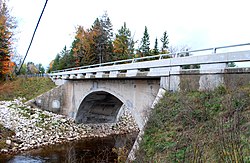
347:, 60 feet (18 m) in length, with a roadway width of 27 feet (8.2 m). The arch sits on large concrete abutments with angled wingwalls. The roadway approaches are flanked with cobblestone retaining walls. The original guardrail was removed during the 1929–30 road widening and replaced with ornamental steel rails with concrete bulkheads. This rail design, although called a "standard" design, appears to be unique among surviving bridges in Michigan. The Mackinac Trail–Carp River Bridge is one of the few remaining arch bridges constructed by the Michigan State Highway Department during its early period of design and construction.
281:
59:
76:
395:
101:
359:
371:
383:
108:
83:
334:
In 2009, the bridge was considered for demolition. However, it was decided in 2010 to refurbish the bridge instead. Weakened concrete was replaced, drains installed, and the roadway was widened by another five feet (1.5 m). The
Mackinac Trail–Carp River Bridge still carries local traffic.
601:
621:
409:
404:
319:(US 2) increasing the traffic flow across the bridge. In response, in 1929–30, new guardrails were added to the bridge, the deck was widened by five feet (1.5 m), and new approaches of decorative
611:
300:. The improvement project included both grading the road surface and upgrading the bridges along the roadway. For one of these bridges, which carried the Mackinac Trail over the
616:
142:
586:
636:
100:
399:
75:
631:
289:
308:
designed a 60-foot (18 m) concrete arch bridge in 1919. The department awarded the contract to construct the bridge to A. S. Decker of
437:
269:
45:
606:
305:
543:
565:
525:
328:
253:
261:
130:
459:
301:
257:
214:
494:
280:
58:
297:
324:
265:
316:
626:
442:
293:
17:
375:
219:
363:
387:
358:
309:
370:
232:
595:
502:
344:
320:
157:
144:
327:, and the Mackinac Trail was redesignated as a county road, later numbered
410:
National
Register of Historic Places listings in Mackinac County, Michigan
405:
List of bridges on the
National Register of Historic Places in Michigan
602:
Road bridges on the
National Register of Historic Places in Michigan
279:
622:
National
Register of Historic Places in Mackinac County, Michigan
432:
323:
were constructed. The section of US 2 was later replaced by
315:
This section of the
Mackinac Trail was later incorporated into
501:. Michigan State Housing Development Authority. Archived from
288:
In 1913, road improvement began on the
Mackinac Trail a
107:
82:
612:
Buildings and structures in
Mackinac County, Michigan
238:
225:
213:
205:
197:
189:
181:
173:
136:
124:
400:National Register of Historic Places portal
8:
544:"Funding May Be a Challenge for Gorman Road"
312:, who completed work on the bridge in 1920.
617:Transportation in Mackinac County, Michigan
343:The Mackinac Trail–Carp River Bridge is an
57:
46:U.S. National Register of Historic Places
489:
487:
485:
483:
481:
479:
477:
421:
559:
557:
526:"Mackinac Trail Projects Moving Ahead"
433:"National Register Information System"
427:
425:
29:
637:Concrete bridges in the United States
7:
566:"Carp River Bridge Upgrade Underway"
454:
452:
438:National Register of Historic Places
270:National Register of Historic Places
564:Ayala, Michael (October 7, 2010).
524:Ayala, Michael (October 8, 2009).
495:"Mackinac Trail/Carp River Bridge"
25:
18:Mackinac Trail – Carp River Bridge
632:Arch bridges in the United States
306:Michigan State Highway Department
201:Michigan State Highway Department
393:
381:
369:
357:
250:Mackinac Trail–Carp River Bridge
106:
99:
81:
74:
38:Mackinac Trail–Carp River Bridge
587:Images from HistoricBridges.org
220:Highway Bridges of Michigan MPS
227:
1:
264:. It is the oldest bridge in
262:St. Ignace Township, Michigan
131:St. Ignace Township, Michigan
115:Show map of the United States
128:Mackinac Trail over Carp R.,
27:United States historic place
653:
256:(Mackinac Trail) over the
607:Bridges completed in 1920
226:NRHP reference
68:
56:
52:
43:
36:
32:
268:, and was listed on the
206:Architectural style
460:"Mackinac Trail Bridge"
290:state trunkline highway
252:is a bridge located on
376:Engineering portal
285:
499:Historic Sites Online
462:. HistoricBridges.org
443:National Park Service
283:
158:46.01833°N 84.71833°W
550:. December 16, 2010.
505:on December 24, 2012
364:Transport portal
90:Show map of Michigan
388:Michigan portal
317:U.S. Highway 2
163:46.01833; -84.71833
154: /
286:
177:less than one acre
284:Bridge deck, 2012
246:
245:
242:December 17, 1999
63:Bridge arch, 2012
16:(Redirected from
644:
574:
573:
561:
552:
551:
540:
534:
533:
521:
515:
514:
512:
510:
491:
472:
471:
469:
467:
456:
447:
446:
429:
398:
397:
396:
386:
385:
384:
374:
373:
362:
361:
298:Sault Ste. Marie
229:
169:
168:
166:
165:
164:
159:
155:
152:
151:
150:
147:
116:
110:
109:
103:
91:
85:
84:
78:
61:
30:
21:
652:
651:
647:
646:
645:
643:
642:
641:
592:
591:
583:
578:
577:
570:St. Ignace News
563:
562:
555:
548:St. Ignace News
542:
541:
537:
530:St. Ignace News
523:
522:
518:
508:
506:
493:
492:
475:
465:
463:
458:
457:
450:
445:. July 9, 2010.
431:
430:
423:
418:
394:
392:
382:
380:
368:
356:
353:
341:
310:Flint, Michigan
278:
266:Mackinac County
162:
160:
156:
153:
148:
145:
143:
141:
140:
129:
120:
119:
118:
117:
114:
113:
112:
111:
94:
93:
92:
89:
88:
87:
86:
64:
48:
39:
28:
23:
22:
15:
12:
11:
5:
650:
648:
640:
639:
634:
629:
624:
619:
614:
609:
604:
594:
593:
590:
589:
582:
581:External links
579:
576:
575:
553:
535:
516:
473:
448:
420:
419:
417:
414:
413:
412:
407:
402:
390:
378:
366:
352:
349:
340:
337:
277:
274:
244:
243:
240:
236:
235:
230:
223:
222:
217:
211:
210:
207:
203:
202:
199:
195:
194:
191:
187:
186:
183:
179:
178:
175:
171:
170:
138:
134:
133:
126:
122:
121:
105:
104:
98:
97:
96:
95:
80:
79:
73:
72:
71:
70:
69:
66:
65:
62:
54:
53:
50:
49:
44:
41:
40:
37:
34:
33:
26:
24:
14:
13:
10:
9:
6:
4:
3:
2:
649:
638:
635:
633:
630:
628:
625:
623:
620:
618:
615:
613:
610:
608:
605:
603:
600:
599:
597:
588:
585:
584:
580:
571:
567:
560:
558:
554:
549:
545:
539:
536:
531:
527:
520:
517:
504:
500:
496:
490:
488:
486:
484:
482:
480:
478:
474:
461:
455:
453:
449:
444:
440:
439:
434:
428:
426:
422:
415:
411:
408:
406:
403:
401:
391:
389:
379:
377:
372:
367:
365:
360:
355:
354:
350:
348:
346:
338:
336:
332:
330:
326:
325:Interstate 75
322:
318:
313:
311:
307:
303:
299:
295:
291:
282:
275:
273:
271:
267:
263:
259:
255:
251:
241:
239:Added to NRHP
237:
234:
231:
224:
221:
218:
216:
212:
209:spandrel arch
208:
204:
200:
196:
192:
188:
184:
180:
176:
172:
167:
139:
135:
132:
127:
123:
102:
77:
67:
60:
55:
51:
47:
42:
35:
31:
19:
627:U.S. Route 2
569:
547:
538:
529:
519:
507:. Retrieved
503:the original
498:
464:. Retrieved
436:
342:
333:
314:
287:
249:
247:
193:A. S. Decker
345:arch bridge
339:Description
321:cobblestone
292:connecting
161: /
137:Coordinates
596:Categories
416:References
302:Carp River
294:St. Ignace
258:Carp River
272:in 1999.
198:Architect
149:84°43′6″W
466:June 13,
351:See also
233:99001528
190:Built by
146:46°1′6″N
125:Location
509:May 21,
276:History
304:, the
182:Built
511:2012
468:2012
329:H-63
296:and
254:H-63
248:The
185:1920
174:Area
260:in
228:No.
215:MPS
598::
568:.
556:^
546:.
528:.
497:.
476:^
451:^
441:.
435:.
424:^
331:.
572:.
532:.
513:.
470:.
20:)
Text is available under the Creative Commons Attribution-ShareAlike License. Additional terms may apply.