34:
46:
104:
Marl') and above this the
Brotherton Formation (formerly the 'Upper Magnesian Limestone'). In the north, the Lower Magnesian Limestone is now referred to as the Raisby Formation and the middle Magnesian Limestone as the Ford Formation. The Upper Magnesian Limestone is replaced by the Roker Formation
116:
but also for aggregate for road-building and other construction purposes. It is also used in the production of agricultural lime. This type of limestone was used for statues in antiquity because of its resistance to acid. Many pieces of dolomite were found in the ruins of Rome, though they are
105:(in its lower part) and the Seaham Formation (in its upper part) with the Edlington formation between them, though in the Durham area this last is replaced by the Fordham Evaporite Formation and the Seaham Residue.
201:
45:
33:
112:, i.e. calcium magnesium carbonate, and has been for many years the main source of dolomite-rock in Britain. It is used in connection with the production of
89:. The term has now been discontinued in formal use though it appears widely in popular and scientific literature on the geology of northern England.
221:
226:
38:
118:
20:
96:. In the southern part of its outcrop, the former 'Lower Magnesian Limestone' is now referred to as the '
185:
97:
137:
British
Geological Survey 1:625,000 scale geological maps (North and South sheets) 3rd edition 1979
113:
194:
109:
93:
27:
173:
58:
215:
86:
78:
101:
82:
70:
74:
66:
62:
44:
32:
100:'. Overlying this it is the 'Edlington Formation' (formerly the '
176:, George Shaw, Richard Pearson, C, & R. Baldwin (1809). "".
178:
148:
British
Regional Geology: the Pennines and adjacent areas
92:
The
Magnesian Limestone is now incorporated within the
49:
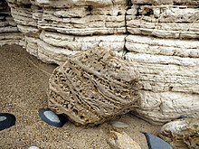
Cellular patterns in a boulder of
Magnesian Limestone
163:(5th ed.) (British Geological Survey, Nottingham)
150:(4th ed.) (British Geological Survey, Nottingham)
8:
81:where it is exposed along the coast between
161:British Regional Geology: Northern England
26:For general magnesium-rich limestone, see
200:CS1 maint: multiple names: authors list (
130:
183:
7:
108:Much of the Magnesian Limestone is
69:period. The outcrop stretches from
37:The cliffs of Magnesian Limestone,
16:Suite of carbonate rocks in England
117:thought to have been brought from
14:
1:
146:Aitkenhead, N., et al 2002.
243:
25:
18:
193:Cite uses generic title (
222:Permian System of Europe
19:Not to be confused with
159:Stone, P., et al 2010
50:
42:
21:Magnesian Conglomerate
48:
36:
73:northwards through
55:Magnesian Limestone
227:Geology of England
51:
43:
114:refractory bricks
234:
206:
205:
198:
191:
189:
181:
170:
164:
157:
151:
144:
138:
135:
98:Cadeby Formation
65:dating from the
242:
241:
237:
236:
235:
233:
232:
231:
212:
211:
210:
209:
199:
192:
182:
172:
171:
167:
158:
154:
145:
141:
136:
132:
127:
94:Zechstein Group
59:carbonate rocks
31:
28:Dolomite (rock)
24:
17:
12:
11:
5:
240:
238:
230:
229:
224:
214:
213:
208:
207:
174:Charles Hutton
165:
152:
139:
129:
128:
126:
123:
102:Middle Permian
61:in north-east
57:is a suite of
15:
13:
10:
9:
6:
4:
3:
2:
239:
228:
225:
223:
220:
219:
217:
203:
196:
187:
179:
175:
169:
166:
162:
156:
153:
149:
143:
140:
134:
131:
124:
122:
120:
115:
111:
106:
103:
99:
95:
90:
88:
87:South Shields
84:
80:
79:County Durham
76:
72:
68:
64:
60:
56:
47:
40:
35:
29:
22:
186:cite journal
177:
168:
160:
155:
147:
142:
133:
107:
91:
54:
52:
121:in Greece.
216:Categories
125:References
83:Hartlepool
71:Nottingham
39:Grangetown
77:and into
75:Yorkshire
41:promenade
119:Magnesia
110:dolomite
67:Permian
63:England
202:link
195:help
85:and
53:The
218::
190::
188:}}
184:{{
204:)
197:)
180:.
30:.
23:.
Text is available under the Creative Commons Attribution-ShareAlike License. Additional terms may apply.