27:
1292:
1349:
271:
247:
235:
259:
283:
35:
295:
340:, were once the dominant plant community in the ecoregion, In relatively intact woodlands the trees reach 12 to 18 meters high, and tree cover averages 50% or more. Grasses form the understory The highest-elevation areas, from 1,200 to 1,494 meters elevation, are home to a mix of lowland (Sudanian) and montane and submontane (
304:
387:
are the most important, along with about 30 other species. Domestic sheep, goats, and cattle are kept and fed in pens during the crop-growing season, and their manure is deposited on the terraces after each harvest. Domestic animals are allowed to graze on the terraces' plant stubble after harvest to
362:
The
Mandara Mountains sustain a relatively dense population, despite the topography and relatively poor soils. Historically the mountains were a refuge for people resisting conquest or enslavement by states on the surrounding plains, and the mountains sustain a great diversity of languages and
205:, fragmenting and splitting as it was pushed to the surface. The climate was significantly wetter in those times, so enormous amounts of precipitation formed numerous rivers that rushed through these fractures, carving them deeper and wider, resulting in the range's notably rugged terrain.
366:
Local people developed a system of intensive agriculture involving the construction of terraces and measures to retain and improve soil fertility. Terraces were built on hillsides to protect soil from erosion, and can extend from valleys to the high mountain slopes. Crop rotation between
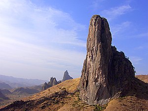
223:. In the case of the Mandara Mountains, the plugs were much more erosion-resistant than the exterior of the cones, which wore away over time. Eventually, only the plugs remained, forming the stark, needle-like spires such as Kapsiki Peak that the range is known for.
533:
Riddell, James C., and David J. Campbell. “Agricultural
Intensification and Rural Development: The Mandara Mountains of North Cameroon.” African Studies Review, vol. 29, no. 3, 1986, pp. 89–106. JSTOR, www.jstor.org/stable/524085. Accessed 7 Aug.
316:
The ecoregion has tropical savanna climate, moderated by elevation. Average annual rainfall varies from 800 to 1000 mm depending on location. Most rain falls during the long wet season from May to
October, and the rest of the year is dry.
344:) species, including some rare and endemic plants and reptiles. The vegetation has been profoundly altered by heavy grazing, burning, and conversion to agriculture, and only fragmented and degraded areas of woodland remain.
574:
567:
560:
1333:
1390:
354:
in
Cameroon cover lower-elevation portions of the mountains. The high peaks, which are of the greatest biological interest, are unprotected.
1409:
906:
1414:
1434:
1419:
1127:
440:
1439:
1326:
1424:
1383:
1429:
388:
ensure that the manure fertilizes the fields. Household, human, and plant waste is used to improve the soil on terraces.
331:
The higher elevation and rainfall of the mountains sustained plant communities distinct from the surrounding lowlands.
51:
131:
1319:
720:
270:
96:
1376:
1097:
347:
61:
750:
351:
375:, and legumes maintains soil fertility and reduces pests. Trees are used for shade, fodder, and green manure.
246:
1039:
234:
1444:
1117:
1087:
1029:
818:
326:
715:
1132:
1112:
999:
652:
258:
725:
891:
1256:
783:
745:
740:
871:
50:
are a volcanic range extending about 190 km (about 120 mi) along the northern part of the
1207:
1122:
1014:
813:
687:
630:
954:
1271:
1241:
1192:
1187:
1004:
979:
969:
896:
793:
730:
672:
377:
198:
1077:
397:
1212:
1172:
1147:
1102:
1082:
1019:
989:
974:
921:
866:
861:
846:
436:
282:
26:
1360:
1303:
1167:
1142:
1137:
1067:
808:
788:
735:
710:
644:
625:
615:
336:
1236:
1072:
939:
911:
798:
692:
677:
667:
662:
589:
219:
whose vents were eventually plugged with hardening magma. These hardened cores are called
202:
194:
456:
1251:
1202:
1177:
1157:
1059:
1034:
856:
803:
778:
773:
768:
552:
1403:
1197:
1152:
1092:
1049:
1044:
836:
682:
610:
598:
383:
220:
216:
20:
1291:
1348:
1009:
994:
984:
929:
901:
886:
881:
851:
657:
620:
604:
513:
481:
1107:
1024:
964:
949:
876:
841:
435:. United States of America: Reader's Digest Association, Inc. pp. 226–227.
402:
341:
182:
178:
125:
55:
1246:
1231:
944:
702:
146:
133:
111:
98:
76:
63:
1266:
1261:
1222:
34:
294:
1299:
959:
181:
research has been undertaken in the
Mandara Mountains, including work at
39:
1356:
368:
208:
934:
760:
640:
372:
163:
90:
171:
33:
828:
303:
212:
167:
556:
211:
also played a role in the formation of the range. Eruptions of
193:
The
Mandara Mountains were formed millions of years ago when a
1182:
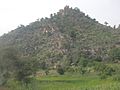
547:
30:
The
Mandara Mountains looking north-east from Jimeta/Yola.
1364:
1307:
162:
The region is densely populated, mainly by speakers of
431:
Scheffel, Richard L.; Wernet, Susan J., eds. (1980).
42:
is one of the most photographed parts of the
Mandara.
1221:
1058:
920:
827:
759:
701:
639:
588:
128:, at 1,494 m (4,900 ft) above sea level (
426:
424:
422:
420:
418:
1384:
1327:
568:
8:
1391:
1377:
1334:
1320:
575:
561:
553:
124:). The highest elevation is the summit of
529:
527:
25:
414:
230:
334:Open woodlands, dominated by the tree
16:Mountain range in Nigeria and Cameroon
508:
506:
504:
502:
457:"A Dormant Volcanic Range in Adamawa"
7:
1345:
1343:
1288:
1286:
907:West and Central African Rift System
583:Major African geological formations
201:deep beneath the African continent
1363:. You can help Knowledge (XXG) by
1306:. You can help Knowledge (XXG) by
14:
482:"Les Diy-Gid-Biy du Mont Mandara"
1347:
1290:
302:
293:
281:
269:
257:
245:
233:
166:languages, including both the
1:
19:For the Indian mountain, see
433:Natural Wonders of the World
1410:Mountain ranges of Cameroon
348:Mozogo-Gokoro National Park
276:View of a pointed Rock form
1461:
1415:Mountain ranges of Nigeria
1342:
1285:
721:Central African Shear Zone
486:UNESCO World Heritage List
324:
18:
1098:Central Pangean Mountains
751:Western Meseta Shear Zone
352:Mayo-Louti Forest Reserve
1435:Cameroon geography stubs
1420:Volcanic plugs of Africa
514:"Mandara Plateau mosaic"
1440:Nigeria geography stubs
363:traditional religions.
252:View of small Mountains
89:) to the north-west of
52:Cameroon–Nigeria border
1359:location article is a
1302:location article is a
1118:Eastern Rift mountains
1040:Tanzania Coastal Basin
819:Terra Australis Orogen
520:. World Wildlife Fund.
518:Terrestrial Ecoregions
327:Mandara Plateau mosaic
43:
31:
1425:Volcanoes of Cameroon
1133:Great Karas Mountains
1113:Eastern Arc Mountains
653:Arabian-Nubian Shield
240:Cross sectional view
37:
29:
1430:Volcanoes of Nigeria
1030:Somali Coastal Basin
741:Mwembeshi Shear Zone
1208:Teffedest Mountains
1123:Ethiopian Highlands
814:Pan-African orogens
784:East African Orogen
716:Broodkop Shear Zone
688:West African Craton
631:Victoria Microplate
143: /
108: /
73: /
1272:List of inselbergs
1242:Jugurtha Tableland
1193:Sankwala Mountains
1188:Rwenzori Mountains
1005:Ouled Abdoun Basin
1000:Orange River Basin
922:Sedimentary basins
731:Foumban Shear Zone
673:Saharan Metacraton
378:Khaya senegalensis
44:
38:Kapsiki Peak near
32:
1372:
1371:
1315:
1314:
1280:
1279:
1213:Tibesti Mountains
1173:Mitumba Mountains
1163:Mandara Mountains
1148:Imatong Mountains
1103:Chaillu Mountains
1083:Bambouk Mountains
1020:Rio del Rey Basin
990:Niger Delta Basin
975:Iullemmeden Basin
867:Gulf of Suez Rift
862:East African Rift
847:Bahr el Arab rift
794:Gondwanide Orogen
726:Chuan Shear Zones
264:The mountain peak
209:Volcanic activity
195:continental plate
147:10.883°N 13.783°E
48:Mandara Mountains
1452:
1393:
1386:
1379:
1351:
1344:
1336:
1329:
1322:
1294:
1287:
1168:Marrah Mountains
1143:Hoggar Mountains
1138:Guinea Highlands
1128:Great Escarpment
892:Sangha Aulacogen
809:Mauritanide Belt
736:Kandi Fault Zone
711:Aswa Dislocation
626:Seychelles Plate
616:Madagascar Plate
577:
570:
563:
554:
535:
531:
522:
521:
510:
497:
496:
494:
492:
478:
472:
471:
469:
467:
453:
447:
446:
428:
337:Isoberlinia doka
306:
297:
285:
273:
261:
249:
237:
158:
157:
155:
154:
153:
148:
144:
141:
140:
139:
136:
123:
122:
120:
119:
118:
113:
109:
106:
105:
104:
101:
88:
87:
85:
84:
83:
78:
74:
71:
70:
69:
66:
1460:
1459:
1455:
1454:
1453:
1451:
1450:
1449:
1400:
1399:
1398:
1397:
1341:
1340:
1283:
1281:
1276:
1237:Mount Gorongosa
1217:
1078:Aurès Mountains
1073:Atlas Mountains
1060:Mountain ranges
1054:
940:Blue Nile Basin
916:
912:White Nile rift
823:
789:Eburnean Orogen
755:
746:Todi Shear Zone
697:
693:Zimbabwe Craton
678:Tanzania Craton
668:Kalahari Craton
663:Kaapvaal Craton
635:
584:
581:
544:
539:
538:
532:
525:
512:
511:
500:
490:
488:
480:
479:
475:
465:
463:
455:
454:
450:
443:
430:
429:
416:
411:
398:Pico Cão Grande
394:
360:
329:
323:
314:
307:
298:
289:
286:
277:
274:
265:
262:
253:
250:
241:
238:
191:
174:ethnic groups.
151:
149:
145:
142:
137:
134:
132:
130:
129:
116:
114:
110:
107:
102:
99:
97:
95:
94:
81:
79:
75:
72:
67:
64:
62:
60:
59:
24:
17:
12:
11:
5:
1458:
1456:
1448:
1447:
1442:
1437:
1432:
1427:
1422:
1417:
1412:
1402:
1401:
1396:
1395:
1388:
1381:
1373:
1370:
1369:
1352:
1339:
1338:
1331:
1324:
1316:
1313:
1312:
1295:
1278:
1277:
1275:
1274:
1269:
1264:
1259:
1257:Mont Niénokoué
1254:
1252:Mulanje Massif
1249:
1244:
1239:
1234:
1228:
1226:
1219:
1218:
1216:
1215:
1210:
1205:
1203:Serra da Chela
1200:
1195:
1190:
1185:
1180:
1178:Nuba Mountains
1175:
1170:
1165:
1160:
1158:Loma Mountains
1155:
1150:
1145:
1140:
1135:
1130:
1125:
1120:
1115:
1110:
1105:
1100:
1095:
1090:
1088:Blue Mountains
1085:
1080:
1075:
1070:
1064:
1062:
1056:
1055:
1053:
1052:
1047:
1042:
1037:
1035:Taoudeni Basin
1032:
1027:
1022:
1017:
1012:
1007:
1002:
997:
992:
987:
982:
977:
972:
967:
962:
957:
952:
947:
942:
937:
932:
926:
924:
918:
917:
915:
914:
909:
904:
899:
894:
889:
884:
879:
874:
872:Lamu Embayment
869:
864:
859:
857:Blue Nile rift
854:
849:
844:
839:
833:
831:
825:
824:
822:
821:
816:
811:
806:
801:
799:Kibaran Orogen
796:
791:
786:
781:
776:
774:Cape Fold Belt
771:
765:
763:
757:
756:
754:
753:
748:
743:
738:
733:
728:
723:
718:
713:
707:
705:
699:
698:
696:
695:
690:
685:
680:
675:
670:
665:
660:
655:
649:
647:
637:
636:
634:
633:
628:
623:
618:
613:
607:
603:Minor plates:
601:
597:Major plates:
594:
592:
586:
585:
582:
580:
579:
572:
565:
557:
551:
550:
543:
542:External links
540:
537:
536:
523:
498:
473:
448:
441:
413:
412:
410:
407:
406:
405:
400:
393:
390:
359:
356:
325:Main article:
322:
319:
313:
310:
309:
308:
301:
299:
292:
290:
287:
280:
278:
275:
268:
266:
263:
256:
254:
251:
244:
242:
239:
232:
221:volcanic plugs
217:volcanic cones
190:
187:
179:archaeological
152:10.883; 13.783
93:in the north (
58:in the south (
15:
13:
10:
9:
6:
4:
3:
2:
1457:
1446:
1445:Adamawa State
1443:
1441:
1438:
1436:
1433:
1431:
1428:
1426:
1423:
1421:
1418:
1416:
1413:
1411:
1408:
1407:
1405:
1394:
1389:
1387:
1382:
1380:
1375:
1374:
1368:
1366:
1362:
1358:
1353:
1350:
1346:
1337:
1332:
1330:
1325:
1323:
1318:
1317:
1311:
1309:
1305:
1301:
1296:
1293:
1289:
1284:
1273:
1270:
1268:
1265:
1263:
1260:
1258:
1255:
1253:
1250:
1248:
1245:
1243:
1240:
1238:
1235:
1233:
1230:
1229:
1227:
1224:
1220:
1214:
1211:
1209:
1206:
1204:
1201:
1199:
1198:Serra da Leba
1196:
1194:
1191:
1189:
1186:
1184:
1183:Rif Mountains
1181:
1179:
1176:
1174:
1171:
1169:
1166:
1164:
1161:
1159:
1156:
1154:
1153:Jebel Uweinat
1151:
1149:
1146:
1144:
1141:
1139:
1136:
1134:
1131:
1129:
1126:
1124:
1121:
1119:
1116:
1114:
1111:
1109:
1106:
1104:
1101:
1099:
1096:
1094:
1093:Cameroon line
1091:
1089:
1086:
1084:
1081:
1079:
1076:
1074:
1071:
1069:
1068:Aïr Mountains
1066:
1065:
1063:
1061:
1057:
1051:
1050:Turkana Basin
1048:
1046:
1045:Tindouf Basin
1043:
1041:
1038:
1036:
1033:
1031:
1028:
1026:
1023:
1021:
1018:
1016:
1015:Reggane Basin
1013:
1011:
1008:
1006:
1003:
1001:
998:
996:
993:
991:
988:
986:
983:
981:
978:
976:
973:
971:
968:
966:
963:
961:
958:
956:
953:
951:
948:
946:
943:
941:
938:
936:
933:
931:
928:
927:
925:
923:
919:
913:
910:
908:
905:
903:
900:
898:
895:
893:
890:
888:
885:
883:
880:
878:
875:
873:
870:
868:
865:
863:
860:
858:
855:
853:
850:
848:
845:
843:
840:
838:
837:Afar Triangle
835:
834:
832:
830:
826:
820:
817:
815:
812:
810:
807:
805:
804:Kuunga Orogen
802:
800:
797:
795:
792:
790:
787:
785:
782:
780:
779:Damara Orogen
777:
775:
772:
770:
769:Alpine Orogen
767:
766:
764:
762:
758:
752:
749:
747:
744:
742:
739:
737:
734:
732:
729:
727:
724:
722:
719:
717:
714:
712:
709:
708:
706:
704:
700:
694:
691:
689:
686:
684:
683:Tuareg Shield
681:
679:
676:
674:
671:
669:
666:
664:
661:
659:
656:
654:
651:
650:
648:
646:
642:
638:
632:
629:
627:
624:
622:
619:
617:
614:
612:
611:Lwandle Plate
609:Microplates:
608:
606:
602:
600:
599:African Plate
596:
595:
593:
591:
587:
578:
573:
571:
566:
564:
559:
558:
555:
549:
548:Mandaras.info
546:
545:
541:
530:
528:
524:
519:
515:
509:
507:
505:
503:
499:
487:
483:
477:
474:
462:
461:Folio Nigeria
458:
452:
449:
444:
442:0-89577-087-3
438:
434:
427:
425:
423:
421:
419:
415:
408:
404:
401:
399:
396:
395:
391:
389:
386:
385:
384:Acacia albida
380:
379:
374:
370:
364:
357:
355:
353:
349:
345:
343:
339:
338:
332:
328:
320:
318:
311:
305:
300:
296:
291:
284:
279:
272:
267:
260:
255:
248:
243:
236:
231:
229:
228:
224:
222:
218:
214:
210:
206:
204:
200:
199:basement rock
196:
188:
186:
185:(DGB) sites.
184:
180:
175:
173:
169:
165:
160:
156:
127:
121:
112:11.0°N 13.9°E
92:
86:
57:
53:
49:
41:
36:
28:
22:
21:Mount Mandara
1365:expanding it
1354:
1308:expanding it
1297:
1282:
1225:(aka koppie)
1162:
1010:Owambo Basin
995:Ogaden Basin
985:Murzuq Basin
955:Douala Basin
930:Angola Basin
902:Urema Valley
887:Red Sea Rift
882:Muglad Basin
852:Benue Trough
658:Congo Craton
621:Rovuma Plate
605:Somali Plate
517:
489:. Retrieved
485:
476:
464:. Retrieved
460:
451:
432:
382:
376:
365:
361:
346:
335:
333:
330:
315:
226:
225:
207:
192:
176:
161:
77:9.3°N 12.8°E
47:
45:
1108:Drakensberg
1025:Sirte Basin
980:Kufra Basin
970:Gabon Basin
965:Karoo Basin
950:Congo Basin
897:Atbara rift
877:Melut Basin
842:Anza trough
703:Shear zones
403:Tororo Rock
342:Afromontane
288:Sunset view
183:Diy-Gid-Biy
150: /
126:Mount Oupay
115: /
80: /
56:Benue River
54:, from the
1404:Categories
1247:Mount Mabu
1232:Anti-Atlas
1223:Inselbergs
945:Chad Basin
409:References
177:Extensive
117:11.0; 13.9
1267:Zuma Rock
1262:Wase Rock
466:17 August
82:9.3; 12.8
1300:Cameroon
960:El Djouf
392:See also
170:and the
40:Rhumsiki
1357:Nigeria
761:Orogens
645:shields
641:Cratons
369:sorghum
321:Ecology
312:Climate
227:Gallery
215:formed
203:rose up
189:Geology
138:13°47′E
135:10°53′N
103:13°54′E
100:11°00′N
68:12°48′E
935:Aoukar
590:Plates
491:29 May
439:
373:millet
358:People
164:Chadic
91:Maroua
65:9°18′N
1355:This
1298:This
829:Rifts
534:2021.
172:Kirdi
1361:stub
1304:stub
643:and
493:2016
468:2020
437:ISBN
381:and
350:and
213:lava
168:Mofu
46:The
197:of
159:).
1406::
526:^
516:.
501:^
484:.
459:.
417:^
371:,
1392:e
1385:t
1378:v
1367:.
1335:e
1328:t
1321:v
1310:.
576:e
569:t
562:v
495:.
470:.
445:.
23:.
Text is available under the Creative Commons Attribution-ShareAlike License. Additional terms may apply.