420:
49:
31:
705:
56:
272:
458:
Its central point remains a small village green with lime trees planted to mark the coronation of King George V in 1911. Many larger stone houses and slate-roofed cottages still stand amid the later buildings. The public services that remain include a church, a pub, a village hall, a residential home
447:
Manton stands on high ground with good water wells that remain in St Mary's Road and Priory Road. The placenames refer to the Priory
College of Blessed Mary, founded in 1356 by Sir William Wade, and active until the dissolution of the monasteries, when the land was given to
570:
439:
Manton does not appear in the 1086 Domesday Book, but may have been one of seven outlying estates of the king's manor of "Hameldune
Cherchesoch". One of the early mentions of Manton Manor dates from the reign of
444:(1100–1135). It remained a dominant feature of the village until the early 20th century, although it changed hands many times between the Abbots of Cluny, the Kings of England and those they rewarded.
455:
A main route between London and
Yorkshire passed through in the 16th century. The main occupations were pasturing of sheep, cattle and horses, and farming of grass, wheat and other crops.
482:, situated to the south of the village. It closed in the 1960s and the station buildings are now used as a factory. The line remains and passes underneath the village through a tunnel.
312:
516:
158:
289:
296:
320:
117:
258:
449:
356:
284:
729:
538:
419:
338:
301:
246:
212:
176:
48:
110:
724:
35:
709:
92:
348:
343:
226:
479:
277:
140:
441:
436:
The name of the village probably means "farm/settlement of Manna" or "communal farm/settlement".
413:
194:
133:
100:
646:
635:
251:
610:
545:
500:
The village's outdoor Chater Close playground and skate ramps are popular with children.
596:
471:
Manton is served by an hourly daytime bus service, Monday to Friday, between Oakham and
611:"College: Blessed Mary at Manton Page 163 A History of the County of Rutland: Volume"
718:
680:
460:
405:
397:
202:
424:
409:
658:
497:
Regular social events are held, including book club meetings and safari suppers.
459:
and an antique shop. The environment changed radically with the emergence of
371:
358:
236:
30:
704:
401:
393:
218:
184:
166:
148:
69:
127:
490:
Manton has a number of attractions, including the newly refurbished
472:
418:
494:. This is the only pub on the cycle route around Rutland Water.
311:
295:
283:
271:
257:
245:
235:
225:
211:
193:
175:
157:
139:
125:
109:
98:
87:
79:
23:
412:at the 2001 census was 364, and after including
544:. Rutland County Council. 2001. Archived from
416:decreased slightly to 359 at the 2011 census.
8:
20:
661:. Manton Parish Council. 23 February 2016
83:1.85 sq mi (4.8 km)
683:. The Skateparks Project. 26 March 2015
508:
310:
266:
234:
210:
124:
108:
78:
27:
294:
282:
270:
256:
244:
224:
192:
174:
156:
138:
97:
7:
478:The village had a railway station,
539:"Rutland Civil Parish Populations"
517:"A vision of Britain through time"
14:
703:
577:. Office for National Statistics
54:
47:
29:
617:. Victoria County History, 1908
571:"Civil Parish population 2011"
392:is a village in the county of
55:
1:
597:"Key to English Place-names"
423:Manton up coal train under
111:OS grid reference
18:Human settlement in England
746:
519:. University of Portsmouth
730:Civil parishes in Rutland
329:
307:
267:
42:
28:
575:Neighbourhood Statistics
408:. The population of the
404:. It lies south-west of
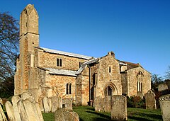
36:St Mary's Church, Manton
450:Gregory, Baron Cromwell
132:82 miles (132 km)
615:British History Online
428:
247:Postcode district
177:Ceremonial county
141:Unitary authority
105:197/sq mi (76/km)
712:at Wikimedia Commons
422:
681:"Manton Skate Ramps"
659:"Manton Playgrounds"
636:Parish Council site.
227:Sovereign state
725:Villages in Rutland
368: /
551:on 12 October 2007
429:
321:Rutland and Melton
313:UK Parliament
259:Dialling code
708:Media related to
387:
386:
159:Shire county
737:
707:
693:
692:
690:
688:
677:
671:
670:
668:
666:
655:
649:
644:
638:
633:
627:
626:
624:
622:
607:
601:
600:
593:
587:
586:
584:
582:
567:
561:
560:
558:
556:
550:
543:
535:
529:
528:
526:
524:
513:
492:Horse and Jockey
425:British Railways
383:
382:
380:
379:
378:
373:
372:52.631°N 0.700°W
369:
366:
365:
364:
361:
335:
221:
121:
120:
68:Location within
58:
57:
51:
33:
21:
745:
744:
740:
739:
738:
736:
735:
734:
715:
714:
710:Manton, Rutland
701:
696:
686:
684:
679:
678:
674:
664:
662:
657:
656:
652:
645:
641:
634:
630:
620:
618:
609:
608:
604:
595:
594:
590:
580:
578:
569:
568:
564:
554:
552:
548:
541:
537:
536:
532:
522:
520:
515:
514:
510:
506:
488:
480:Manton Junction
469:
434:
376:
374:
370:
367:
362:
359:
357:
355:
354:
353:
333:
325:
217:
207:
189:
171:
153:
116:
115:
75:
74:
73:
72:
66:
65:
64:
63:
59:
38:
19:
12:
11:
5:
743:
741:
733:
732:
727:
717:
716:
700:
699:External links
697:
695:
694:
672:
650:
639:
628:
602:
588:
562:
530:
507:
505:
502:
487:
484:
468:
465:
463:in the 1970s.
433:
430:
385:
384:
377:52.631; -0.700
352:
351:
346:
341:
336:
334:List of places
330:
327:
326:
324:
323:
317:
315:
309:
308:
305:
304:
299:
293:
292:
290:Leicestershire
287:
281:
280:
278:Leicestershire
275:
269:
268:
265:
264:
261:
255:
254:
249:
243:
242:
239:
233:
232:
231:United Kingdom
229:
223:
222:
215:
209:
208:
206:
205:
199:
197:
191:
190:
188:
187:
181:
179:
173:
172:
170:
169:
163:
161:
155:
154:
152:
151:
145:
143:
137:
136:
130:
123:
122:
113:
107:
106:
103:
96:
95:
89:
85:
84:
81:
77:
76:
67:
61:
60:
53:
52:
46:
45:
44:
43:
40:
39:
34:
26:
25:
17:
13:
10:
9:
6:
4:
3:
2:
742:
731:
728:
726:
723:
722:
720:
713:
711:
706:
698:
682:
676:
673:
660:
654:
651:
648:
643:
640:
637:
632:
629:
616:
612:
606:
603:
598:
592:
589:
576:
572:
566:
563:
547:
540:
534:
531:
518:
512:
509:
503:
501:
498:
495:
493:
485:
483:
481:
476:
474:
466:
464:
462:
461:Rutland Water
456:
453:
451:
445:
443:
437:
431:
426:
421:
417:
415:
411:
407:
406:Rutland Water
403:
399:
398:East Midlands
395:
391:
381:
350:
347:
345:
342:
340:
337:
332:
331:
328:
322:
319:
318:
316:
314:
306:
303:
302:East Midlands
300:
298:
291:
288:
286:
279:
276:
274:
262:
260:
253:
250:
248:
240:
238:
230:
228:
220:
216:
214:
204:
203:East Midlands
201:
200:
198:
196:
186:
183:
182:
180:
178:
168:
165:
164:
162:
160:
150:
147:
146:
144:
142:
135:
131:
129:
119:
114:
112:
104:
102:
94:
90:
86:
82:
71:
50:
41:
37:
32:
22:
16:
702:
685:. Retrieved
675:
663:. Retrieved
653:
642:
631:
619:. Retrieved
614:
605:
591:
579:. Retrieved
574:
565:
553:. Retrieved
546:the original
533:
521:. Retrieved
511:
499:
496:
491:
489:
477:
470:
457:
454:
446:
438:
435:
410:civil parish
389:
388:
15:
621:26 December
486:Attractions
375: /
93:2001 Census
719:Categories
647:Timetable.
504:References
360:52°37′52″N
88:Population
467:Transport
414:Gunthorpe
363:0°42′00″W
297:Ambulance
237:Post town
91:364
555:15 March
523:18 March
118:SK880045
687:2 April
665:2 April
581:25 June
442:Henry I
432:History
402:England
396:in the
394:Rutland
349:Rutland
344:England
219:England
213:Country
185:Rutland
167:Rutland
149:Rutland
126:•
101:Density
99:•
70:Rutland
390:Manton
273:Police
241:OAKHAM
195:Region
128:London
62:Manton
24:Manton
549:(PDF)
542:(PDF)
473:Corby
263:01572
689:2018
667:2018
623:2022
583:2016
557:2009
525:2009
285:Fire
252:LE15
80:Area
400:of
134:SSE
721::
613:.
573:.
475:.
452:.
339:UK
691:.
669:.
625:.
599:.
585:.
559:.
527:.
427:.
Text is available under the Creative Commons Attribution-ShareAlike License. Additional terms may apply.