29:
153:
275:
260:
270:
48:
34:
145:, established in 1983, the largest conservancy of its kind in New Jersey. Parts of the river are also designed as part of the
156:, is a regional watershed organization that focuses its work on the Maurice River watershed, which includes the Manumuskin.
221:
265:
86:
165:
188:
101:
105:
131:
123:
28:
141:
Approximately 3,500 acres (1,400 ha) of the watershed of the river are included in the
192:
130:
of the
Maurice from the northeast approximately 5 miles (8 km) south-southeast of
100:
The
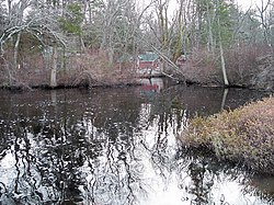
Manumuskin River flows through a relatively pristine forested area in the southern
254:
208:
146:
94:
82:
184:
U.S. Geological Survey. National
Hydrography Dataset high-resolution flowline data.
135:
134:
and approximately 7 miles (11 km) upstream from the mouth of the
Maurice on
112:
90:
236:
223:
213:
78:
185:
127:
154:
Citizens United to
Protect the Maurice River and Its Tributaries, Inc.
116:
108:
214:
National Park
Service: Maurice Wild and Scenic River
122:It rises approximately 5 miles (8 km) east of
55:
46:
21:
126:and flows south-southwest, joining the navigable
209:Cumberland Co., NJ: Manumuskin River Preserve
8:
276:Wild and Scenic Rivers of the United States
261:Rivers of Cumberland County, New Jersey
177:
18:
115:in its lower reaches. The name is of
54:
45:
7:
77:is a 16.3-mile-long (26.2 km)
14:
104:of Cumberland County, as well as
271:Tributaries of the Maurice River
152:A local nonprofit organization,
27:
49:National Wild and Scenic River
1:
147:Maurice Wild and Scenic River
166:List of rivers of New Jersey
292:
143:Manumuskin River Preserve
67:
63:
42:
26:
195:, accessed April 1, 2011
33:The Manumuskin River in
237:39.345284°N 74.961814°W
35:Maurice River Township
242:39.345284; -74.961814
266:Rivers of New Jersey
106:Atlantic white cedar
233: /
191:2012-03-29 at the
87:Cumberland County
71:
70:
283:
248:
247:
245:
244:
243:
238:
234:
231:
230:
229:
226:
196:
186:The National Map
182:
75:Manumuskin River
59:December 1, 1993
31:
22:Manumuskin River
19:
291:
290:
286:
285:
284:
282:
281:
280:
251:
250:
241:
239:
235:
232:
227:
224:
222:
220:
219:
205:
200:
199:
193:Wayback Machine
183:
179:
174:
162:
51:
38:
17:
12:
11:
5:
289:
287:
279:
278:
273:
268:
263:
253:
252:
217:
216:
211:
204:
203:External links
201:
198:
197:
176:
175:
173:
170:
169:
168:
161:
158:
69:
68:
65:
64:
61:
60:
57:
53:
52:
47:
44:
43:
40:
39:
32:
24:
23:
15:
13:
10:
9:
6:
4:
3:
2:
288:
277:
274:
272:
269:
267:
264:
262:
259:
258:
256:
249:
246:
215:
212:
210:
207:
206:
202:
194:
190:
187:
181:
178:
171:
167:
164:
163:
159:
157:
155:
150:
148:
144:
139:
137:
133:
129:
125:
120:
118:
114:
110:
107:
103:
98:
96:
95:United States
92:
88:
84:
83:Maurice River
80:
76:
66:
62:
58:
50:
41:
36:
30:
25:
20:
218:
180:
151:
142:
140:
136:Delaware Bay
121:
113:salt marshes
102:Pine Barrens
99:
74:
72:
240: /
255:Categories
228:74°57′43″W
225:39°20′43″N
172:References
91:New Jersey
56:Designated
132:Millville
79:tributary
189:Archived
160:See also
124:Vineland
119:origin.
128:estuary
93:in the
81:of the
37:in 2006
117:Lenape
16:River
111:and
109:bogs
73:The
85:in
257::
149:.
138:.
97:.
89:,
Text is available under the Creative Commons Attribution-ShareAlike License. Additional terms may apply.