46:
284:
575:
563:
509:
was about 1,700 m/second. The minimum was 95 m/second, the maximum 6,550 m/second. The estuary is approximately 90 km long; the average tidal range in the estuary is 2 m; in the dry season, the salt reaches about 40 km upstream to the town of
622:
394:
In 1860, the question was posed from the French side, which of the two tributary rivers was the headwater, and thus the border. A joint French-Dutch commission was appointed to review the issue. The Dutch side of the commission consisted of
55:
422:
There were no problems with this decision until 1885. However, the discovery of gold in the area between the Lawa and the
Tapanahony created a new border conflict. On 29 November 1888, France and the
541:
and in the 17th century, by
Harcourt, Fisher and De Vries. In the 18th century more extensive excursions took place, by Mentell, Patris, Le Blond and Heneman and in the 19th century by Zegelaar,
548:
Of importance in the 20th century were the Gonini and
Tapanahony expeditions, and the Tumuk Humak and Southern Border Expeditions. From these arose the research of the
712:
707:
407:. Luits Vidal, Ronmy, Boudet and Dr. Rech composed the French side. In 1861 measurements were taken, which produced the following result: the Lawa had a
45:
574:
525:
The Maroni is the most extensively studied of all the rivers in
Suriname. In the 16th century, there were already ships exploring the estuary, by
198:
143:
676:
649:
396:
283:
562:
692:
505:(110 km away from the mouth of the river) this area is 63,700 km. Between 1952 and 1973, the average discharge near
430:, acting as the arbitrator, decided that the Lawa was the headwater of the Maroni, and thus should be considered the border.
433:
However, this decision created another issue as to which river is the source of the Lawa. The
Netherlands considered the
717:
438:
697:
372:
There are two nature preserves located in the estuary region on the
Surinamese side of the river, near the village of
400:
362:
702:
366:
487:
also has its source in the Tumuk Humak
Mountains, at approximately 2° N, 54° W; it also absorbs the
427:
96:
722:
377:
602:
Northern South
America: Guyana, Suriname, French Guiana, northern Brazil, and eastern Venezuela (NT0125)
408:
350:
346:
538:
626:
441:, located further to the west, to be the source of the Lawa. This issue has still not been resolved.
530:
389:
627:"Fiche cours d'eau - maroni, le (fleuve); lawa, la (riviere); alitanie, l' (riviere) (5---0000)"
672:
645:
534:
511:
412:
373:
358:
90:
415:
had a discharge of 20,291 m/minute at a width of 285 m. Thus, the Lawa River was the
526:
304:
484:
476:
434:
404:
317:
309:
184:
686:
542:
517:
The estimated potential hydro power for
Suriname is between 1150 and 1250 megawatts.
501:
330:
322:
273:
1,700 m/s (60,000 cu ft/s) 2,586 m/s (91,300 cu ft/s)
437:(Marowijnekreek in Dutch) to be the source of the Lawa; the French considered the
600:
423:
179:
17:
426:
reached an agreement that the conflict should be subject to arbitration. Czar
361:
of French Guiana) and
Suriname. In its upper reaches, it is also known as the
213:
200:
158:
145:
27:
River in South America, forming the border between Suriname and French Guiana
416:
369:. The total length of Litani, Lawa and Maroni is 612 km (380 mi).
668:
334:
129:
77:
354:
73:
667:. Amsterdam & Brussels 1977, B.V. Uitgeversmaatschappij Argus
54:
329:) is a river in South America that forms the border between
448:
originates in the Tumuk Humak Mountains at approximately
499:
The Maroni basin is 68,700 km; above the island
267:
259:
247:
239:
229:
190:
178:
135:
123:
115:
106:
83:
69:
64:
34:
580:Maroni River, view from French Guiana to Suriname
462:° N 55° W; along its path it is fed by
411:of 35,960 m/minute at a width of 436 m; the
376:. They provide protection for the birds and the
599:Schipper, Jan; Teunissen, Pieter; Lim, Burton,
365:, and close to its source it is known as the
8:
663:C.F.A. Bruijning und J. Voorhoeve (Ed.):
642:Sir Walter Ralegh's Discoverie of Guiana
545:, Coudreau, Ten Kate, Joost and others.
353:and forms the (disputed) border between
282:
591:
558:
251:65,830 km (25,420 sq mi)
214:5.745793169255944°N 53.96842690321619°W
31:
713:International rivers of South America
640:Walter Raleigh. Joyce Lorimer (ed.).
316:
303:
219:5.745793169255944; -53.96842690321619
7:
554:Centraal Bureau voor Luchtkartering
397:J.H. Baron van Heerdt tot Eversberg
25:
550:Geologisch Mijnbouwkundige Dienst
287:Map of the Maroni River from 1896
573:
561:
349:ecoregion. It originates in the
53:
44:
192: • coordinates
137: • coordinates
1:
708:French Guiana–Suriname border
568:Sunrise over the Maroni River
243:611.7 km (380.1 mi)
107:Physical characteristics
345:The Maroni runs through the
231: • elevation
125: • location
739:
401:J.F.A. Cateau van Rosevelt
387:
269: • average
665:Encyclopedie van Suriname
277:
255:
174:
111:
52:
43:
671:, p. 256, 396–397;
644:. Ashgate. p. 360.
318:[ˌmaːroːˈʋɛi̯nə]
693:Rivers of French Guiana
428:Alexander III of Russia
378:leatherback sea turtles
97:Saint-Laurent-du-Maroni
313:
300:
288:
419:of the Maroni River.
351:Tumuk Humak Mountains
347:Guianan moist forests
286:
235:0 m (0 ft)
59:Course of the Maroni
718:Sipaliwini District
390:Borders of Suriname
384:Territorial dispute
210: /
155: /
698:Rivers of Suriname
380:that hatch there.
289:
535:Antonio de Berrio
281:
280:
16:(Redirected from
730:
703:Rivers of France
656:
655:
637:
631:
630:
619:
613:
612:
611:
609:
596:
577:
565:
539:Adriaen Cabeliau
491:, among others.
464:Koele Koelebreek
461:
460:
456:
453:
320:
307:
305:[maʁɔni]
270:
225:
224:
222:
221:
220:
215:
211:
208:
207:
206:
203:
170:
169:
167:
166:
165:
160:
156:
153:
152:
151:
148:
138:
126:
57:
48:
32:
21:
738:
737:
733:
732:
731:
729:
728:
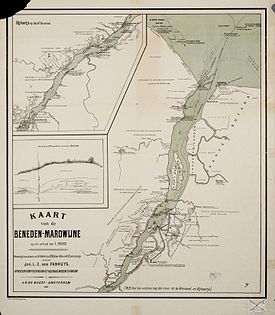
727:
683:
682:
660:
659:
652:
639:
638:
634:
621:
620:
616:
607:
605:
598:
597:
593:
588:
581:
578:
569:
566:
527:Lawrence Keymis
523:
497:
458:
454:
451:
449:
392:
386:
343:
268:
232:
218:
216:
212:
209:
204:
201:
199:
197:
196:
193:
163:
161:
157:
154:
149:
146:
144:
142:
141:
136:
124:
102:
60:
39:
36:
28:
23:
22:
18:Marowijne River
15:
12:
11:
5:
736:
734:
726:
725:
720:
715:
710:
705:
700:
695:
685:
684:
681:
680:
658:
657:
650:
632:
614:
590:
589:
587:
584:
583:
582:
579:
572:
570:
567:
560:
552:(GMD) and the
522:
519:
496:
493:
477:Oelemari River
405:August Kappler
388:Main article:
385:
382:
342:
339:
279:
278:
275:
274:
271:
265:
264:
261:
257:
256:
253:
252:
249:
245:
244:
241:
237:
236:
233:
230:
227:
226:
194:
191:
188:
187:
185:Atlantic Ocean
182:
176:
175:
172:
171:
139:
133:
132:
127:
121:
120:
117:
113:
112:
109:
108:
104:
103:
101:
100:
94:
87:
85:
81:
80:
71:
67:
66:
62:
61:
58:
50:
49:
41:
40:
37:
26:
24:
14:
13:
10:
9:
6:
4:
3:
2:
735:
724:
723:Border rivers
721:
719:
716:
714:
711:
709:
706:
704:
701:
699:
696:
694:
691:
690:
688:
678:
677:90-10-01842-3
674:
670:
666:
662:
661:
653:
651:0-904180-87-5
647:
643:
636:
633:
628:
624:
618:
615:
604:
603:
595:
592:
585:
576:
571:
564:
559:
557:
555:
551:
546:
544:
543:Jules Crevaux
540:
536:
532:
531:Thomas Masham
528:
520:
518:
515:
513:
508:
507:Langatabbetje
504:
503:
502:Langatabbetje
494:
492:
490:
486:
481:
479:
478:
473:
469:
465:
447:
442:
440:
436:
431:
429:
425:
420:
418:
414:
410:
406:
402:
398:
391:
383:
381:
379:
375:
370:
368:
364:
360:
356:
352:
348:
340:
338:
336:
332:
331:French Guiana
328:
324:
319:
315:
311:
306:
302:
298:
294:
285:
276:
272:
266:
262:
258:
254:
250:
246:
242:
238:
234:
228:
223:
195:
189:
186:
183:
181:
177:
173:
168:
140:
134:
131:
128:
122:
118:
114:
110:
105:
98:
95:
92:
89:
88:
86:
82:
79:
75:
72:
68:
63:
56:
51:
47:
42:
33:
30:
19:
664:
641:
635:
617:
606:, retrieved
601:
594:
553:
549:
547:
524:
516:
506:
500:
498:
488:
482:
475:
472:Mapaonikreek
471:
467:
463:
445:
443:
432:
421:
393:
371:
344:
327:Marwina-Liba
326:
323:Sranan Tongo
296:
292:
290:
35:Maroni River
29:
521:Exploration
424:Netherlands
217: /
162: /
687:Categories
586:References
489:Koelebreek
413:Tapanahony
248:Basin size
205:53°58′06″W
93:(Suriname)
417:headwater
409:discharge
314:Marowijne
299:(French:
297:Marowijne
260:Discharge
202:5°44′45″N
70:Countries
38:Marowijne
669:Elsevier
474:and the
468:Lokereek
335:Suriname
159:2°N 54°W
130:Suriname
99:(France)
78:Suriname
65:Location
608:3 April
556:(CBL).
495:Numbers
457:⁄
675:
648:
623:Sandre
512:Albina
485:Malani
470:, the
466:, the
446:Litani
439:Litani
435:Malani
374:Galibi
367:Litani
359:region
355:France
341:Course
301:Maroni
293:Maroni
263:
240:Length
164:2; -54
119:
116:Source
91:Albina
84:Cities
74:France
310:Dutch
180:Mouth
673:ISBN
646:ISBN
610:2017
537:and
483:The
444:The
403:and
363:Lawa
333:and
291:The
150:54°W
76:and
295:or
147:2°N
689::
625:.
533:,
529:,
514:.
480:.
399:,
337:.
325::
321:;
312::
308:;
679:.
654:.
629:.
459:2
455:1
452:+
450:2
357:(
20:)
Text is available under the Creative Commons Attribution-ShareAlike License. Additional terms may apply.