160:
228:
298:
198:
181:
357:
337:
318:
36:
741:
205:
235:
544:. A lot of city people moved to the country side, and Mariakerke witnessed a real population boom. In the 1970s, the city of Ghent started expanding again, slowly but surely absorbing the village of Mariakerke into its urban borders. 1976 saw the fusion of Mariakerke with Ghent, and ever since it has been part of the urban area of
536:
The people from
Mariakerke became more involved in the city life of Ghent once the industrial era had begun. A lot of villagers found a job at the many factories of Ghent, and a lot of rich industrials constructed castles and mansions in the rural Mariakerke. These castles can still be visited today,
584:
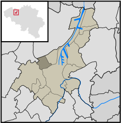
Kolegem is the eastern part of
Mariakerke. Kolegem is separated from the rest of Mariakerke by a canal named Brugse Vaart, a canal between Ghent and Bruges. Some famous buildings in Kolegem are the former municipality house of Mariakerke (now containing only the administrative services), the
517:
Mariakerke obtained the status of independent village in 1793, after which a bridge was constructed to connect both halves of the village. The bridge has been destroyed several times during war, which makes that the actual bridge was put up in 1964.
521:
Besides the bridge, Mariakerke only had one main road which connected the village with the city of Ghent. This road was very important for the village, and still exists today under the name "Brugse
Steenweg".
637:
329:
310:
803:
260:
159:
53:
227:
798:
491:
502:
In the 17th century, Mariakerke was divided in two because of the construction of the "Brugse Vaart", a canal that connects the cities of
100:
72:
623:
119:
79:
630:
197:
86:
57:
180:
439:
68:
602:
369:
46:
487:
381:
533:, one of Ghent's most busy avenues. This new street had a significant impact on the 18th century Mariakerke.
427:
374:
467:
93:
514:. Because of the hundreds of years of separation, both halves developed their own unique atmosphere.
349:
715:
529:, and Mariakerke became a stop along this important road. Nowadays the road is better known as the
530:
720:
322:
463:
146:
762:
710:
17:
479:
458:
342:
792:
772:
475:
362:
757:
655:
541:
35:
730:
685:
668:
510:. The west side is Mariakerke center. The east side of Mariakerke is known as
275:
262:
767:
725:
705:
615:
740:
690:
777:
700:
673:
525:
Later in the 18th century, a trade route was constructed from Ghent to
511:
483:
303:
663:
507:
679:
647:
545:
526:
503:
471:
386:
150:
619:
29:
603:"LISTE ALPHABETIQUE DES COMMUNES - Fusions de 1963 à 1977"
132:
Sub-municipality of Ghent in
Flemish Community, Belgium
748:
654:
438:
426:
418:
410:
405:
397:
392:
380:
368:
348:
328:
309:
291:
137:
60:. Unsourced material may be challenged and removed.
540:Mariakerke finally lost its rural character after
585:Kollekasteel and the restaurant De Groene Staak.
27:Sub-municipality of the city of Ghent, Belgium
631:
537:and add a special atmosphere to the village.
8:
638:
624:
616:
134:
120:Learn how and when to remove this message
594:
425:
404:
391:
290:
255:
189:
168:
156:
804:Former municipalities of East Flanders
490:until 1977. On 1 January 1977, it was
457:
437:
417:
409:
396:
379:
367:
347:
327:
308:
177:
7:
58:adding citations to reliable sources
401:5.20 km (2.01 sq mi)
234:
204:
25:
739:
569:Castle van Tieghem de ten Berghe
355:
335:
316:
296:
233:
226:
203:
196:
179:
158:
34:
185:Location of Mariakerke in Ghent
45:needs additional citations for
1:
566:Castle Kervyn d'oudt Mooregem
164:Onze-Lieve-Vrouw Geboortekerk
799:Sub-municipalities of Ghent
572:White castle or Henri Story
422:3,300/km (8,600/sq mi)
69:"Mariakerke, East Flanders"
820:
18:Mariakerke (East Flanders)
737:
476:province of East Flanders
459:[maːˈrijaːˌkɛrkə]
256:
247:Show map of East Flanders
190:
178:
169:
157:
144:
557:Castle Claeys-Bouüaert
172:Location of Mariakerke
751:villages and hamlets
646:Populated places in
486:. It was a separate
455:Dutch pronunciation:
419: • Density
276:51.07278°N 3.67611°E
54:improve this article
716:Sint-Denijs-Westrem
560:Castle de Hemptinne
272: /
217:Show map of Belgium
656:Sub-municipalities
411: • Total
398: • Total
786:
785:
721:Sint-Kruis-Winkel
575:Castle les Cygnes
448:
447:
323:Flemish Community
281:51.07278; 3.67611
130:
129:
122:
104:
16:(Redirected from
811:
743:
640:
633:
626:
617:
610:
609:
607:
599:
563:Castle ter Beken
464:sub-municipality
461:
456:
361:
359:
358:
341:
339:
338:
321:
320:
319:
302:
300:
299:
287:
286:
284:
283:
282:
277:
273:
270:
269:
268:
265:
248:
237:
236:
230:
218:
207:
206:
200:
183:
162:
147:Sub-municipality
135:
125:
118:
114:
111:
105:
103:
62:
38:
30:
21:
819:
818:
814:
813:
812:
810:
809:
808:
789:
788:
787:
782:
750:
749:Neighbourhoods,
744:
735:
711:Sint-Amandsberg
650:
644:
614:
613:
605:
601:
600:
596:
591:
582:
554:
500:
474:located in the
454:
434:
356:
354:
336:
334:
317:
315:
297:
295:
280:
278:
274:
271:
266:
263:
261:
259:
258:
252:
251:
250:
249:
246:
245:
244:
243:
242:
238:
221:
220:
219:
216:
215:
214:
213:
212:
208:
186:
174:
173:
165:
153:
140:
133:
126:
115:
109:
106:
63:
61:
51:
39:
28:
23:
22:
15:
12:
11:
5:
817:
815:
807:
806:
801:
791:
790:
784:
783:
781:
780:
775:
770:
765:
760:
754:
752:
746:
745:
738:
736:
734:
733:
728:
723:
718:
713:
708:
703:
698:
693:
688:
683:
676:
671:
666:
660:
658:
652:
651:
645:
643:
642:
635:
628:
620:
612:
611:
593:
592:
590:
587:
581:
578:
577:
576:
573:
570:
567:
564:
561:
558:
553:
550:
499:
496:
480:Flemish Region
446:
445:
442:
436:
435:
432:
430:
424:
423:
420:
416:
415:
412:
408:
407:
403:
402:
399:
395:
394:
390:
389:
384:
378:
377:
372:
370:Arrondissement
366:
365:
352:
346:
345:
343:Flemish Region
332:
326:
325:
313:
307:
306:
293:
289:
288:
254:
253:
240:
239:
232:
231:
225:
224:
223:
222:
210:
209:
202:
201:
195:
194:
193:
192:
191:
188:
187:
184:
176:
175:
171:
170:
167:
166:
163:
155:
154:
145:
142:
141:
138:
131:
128:
127:
42:
40:
33:
26:
24:
14:
13:
10:
9:
6:
4:
3:
2:
816:
805:
802:
800:
797:
796:
794:
779:
776:
774:
771:
769:
766:
764:
761:
759:
756:
755:
753:
747:
742:
732:
729:
727:
724:
722:
719:
717:
714:
712:
709:
707:
704:
702:
699:
697:
694:
692:
689:
687:
684:
682:
681:
677:
675:
672:
670:
667:
665:
662:
661:
659:
657:
653:
649:
641:
636:
634:
629:
627:
622:
621:
618:
604:
598:
595:
588:
586:
579:
574:
571:
568:
565:
562:
559:
556:
555:
551:
549:
547:
543:
538:
534:
532:
528:
523:
519:
515:
513:
509:
505:
497:
495:
493:
489:
485:
481:
477:
473:
469:
465:
460:
452:
443:
441:
431:
429:
421:
413:
400:
388:
385:
383:
376:
373:
371:
364:
363:East Flanders
353:
351:
344:
333:
331:
324:
314:
312:
305:
294:
285:
257:Coordinates:
229:
199:
182:
161:
152:
148:
143:
136:
124:
121:
113:
102:
99:
95:
92:
88:
85:
81:
78:
74:
71: –
70:
66:
65:Find sources:
59:
55:
49:
48:
43:This article
41:
37:
32:
31:
19:
695:
678:
597:
583:
542:World War II
539:
535:
524:
520:
516:
501:
494:into Ghent.
488:municipality
450:
449:
428:Postal codes
382:Municipality
116:
107:
97:
90:
83:
76:
64:
52:Please help
47:verification
44:
279: /
793:Categories
731:Zwijnaarde
696:Mariakerke
686:Gentbrugge
669:Desteldonk
589:References
451:Mariakerke
440:Area codes
406:Population
241:Mariakerke
211:Mariakerke
139:Mariakerke
80:newspapers
768:Luchteren
726:Wondelgem
706:Oostakker
311:Community
267:3°40′34″E
264:51°4′22″N
110:June 2024
763:Dampoort
691:Ledeberg
350:Province
778:Kolegem
701:Mendonk
674:Drongen
580:Kolegem
552:Castles
512:Kolegem
498:History
484:Belgium
466:of the
462:) is a
304:Belgium
292:Country
94:scholar
773:Moscou
664:Afsnee
508:Bruges
492:merged
414:17,241
360:
340:
330:Region
301:
96:
89:
82:
75:
67:
758:Malem
680:Ghent
648:Ghent
606:(PDF)
546:Ghent
527:Eeklo
504:Ghent
472:Ghent
387:Ghent
375:Ghent
151:Ghent
101:JSTOR
87:books
506:and
468:city
433:9030
393:Area
73:news
470:of
149:of
56:by
795::
548:.
531:N9
482:,
478:,
444:09
639:e
632:t
625:v
608:.
453:(
123:)
117:(
112:)
108:(
98:·
91:·
84:·
77:·
50:.
20:)
Text is available under the Creative Commons Attribution-ShareAlike License. Additional terms may apply.