52:
45:
326:
476:. A pyramidal peak, rising to about 4,000 metres (13,000 ft) high on the northwest margin of the Markham Plateau, 3 nautical miles (5.6 km; 3.5 mi) west of Mount Markham. Named by US-ACAN in 1988 after geologist Russell J. Korsch who, with E. Stump and D. Egerton, climbed and geologically mapped this peak on December 3, 1985, as a member of a USARP field party. Korsch was a member of
853:
803:
606:. A mountain, 1,490 metres (4,890 ft) high, standing at the east side of the mouth of DeBreuck Glacier at its juncture with Kent Glacier. Mapped by the USGS from tellurometer surveys and Navy air photos, 1960-62. Named by the US-ACAN for Jack V. Tedrow, USARP glaciologist at McMurdo Station, 1959-60, 1960-61.
388:. A small, but prominent, high plateau which extends south from Mount Markham for about 10 nautical miles (19 km; 12 mi) and forms the divide between east and west-flowing glaciers in the north part of the Queen Elizabeth Range. Mapped by the
564:. A hill 2 nautical miles (3.7 km; 2.3 mi) west of Mount Tedrow, on the south side of Kent Glacier. Mapped by the USGS from tellurometer surveys and Navy air photos, 1960-62. Named by US-ACAN for Stoner B. Haven, USARP biologist at
857:
807:
518:. A projecting-type mountain on the east side of Markham Plateau. Mapped by the USGS from tellurometer surveys and Navy air photos, 1960-62. Named by the US-ACAN for John P. Katsufrakis, USARP radio scientist at
648:. Mapped by the USGS from tellurometer surveys and Navy air photos, 1960-62. Named by the US-ACAN for Martin C. Predoehl, USARP meteorologist at McMurdo Station, 1961-62 and 1962-63.
345:, and northeast of the Markham Plateau. Nearby features include Mount Lysaght to the north, Mount Katsufrakis to the south and Haven Hill, Mount Tedrow and Mount Predoehl to the east.
434:. A peak, 3,755 metres (12,320 ft) high, standing 1.5 nautical miles (2.8 km; 1.7 mi) north of Mount Markham. Discovered and named by the
435:
124:
878:
477:
888:
811:
44:
393:
259:
205:
247:
191:
861:
389:
117:
267:
883:
616:
578:
536:
490:
448:
406:
360:
287:
250:
of
Antarctica. The peaks have elevations of 4,350 metres (14,270 ft) and 4,280 metres (14,040 ft).
95:
110:
314:
325:
271:
309:
105:
304:
263:
173:
64:
392:(USGS) from tellurometer surveys and Navy air photos, 1960-62. Named by the United States
836:
644:. A partly snow-covered mountain, 1,710 metres (5,610 ft) high, just north of lower
519:
818:
645:
184:
480:(USARP) field parties, 1968-69 and 1985-86; NZARP field parties, 1982-83 and 1984-85.
872:
565:
338:
785:
523:
342:
333:
Mount
Markham is in the northern part of the Queen Elizabeth Range. It is south of
17:
334:
177:
68:
631:
618:
593:
580:
551:
538:
505:
492:
463:
450:
421:
408:
375:
362:
299:
221:
207:
140:
126:
662:
660:
243:
85:
679:
677:
675:
666:
246:
surmounting the north end of the
Markham Plateau in the
793:(2 ed.), United States Board on Geographic Names
183:
169:
164:
116:
104:
94:
84:
79:
32:
695:
396:(US-ACAN) in association with Mount Markham.
8:
29:
478:United States Antarctic Research Program
324:
841:, USGS: United States Geological Survey
812:United States Board on Geographic Names
767:
755:
743:
731:
719:
707:
683:
656:
27:Mountain in Ross Dependency, Antarctica
436:British Antarctic Expedition, 1907–09
394:Advisory Committee on Antarctic Names
260:British National Antarctic Expedition
51:
7:
258:Mount Markham was discovered by the
270:, planned the expedition and chose
262:of 1901–1904). It is named for Sir
860:from websites or documents of the
810:from websites or documents of the
329:Cotton Plateau in southwest of map
25:
787:Geographic Names of the Antarctic
879:Mountains of the Ross Dependency
856: This article incorporates
851:
806: This article incorporates
801:
50:
43:
862:United States Geological Survey
390:United States Geological Survey
889:Four-thousanders of Antarctica
819:"Antarctica Ultra-Prominences"
784:Alberts, Fred G., ed. (1995),
1:
90:4,350 m (14,270 ft)
667:Antarctica Ultra-Prominences
100:2,103 m (6,900 ft)
315:GPX (secondary coordinates)
266:, who, as President of the
905:
268:Royal Geographical Society
310:GPX (primary coordinates)
285:Map all coordinates using
37:
293:Download coordinates as:
526:, 1964-65 and 1965-66.
858:public domain material
808:public domain material
330:
328:
305:GPX (all coordinates)
248:Queen Elizabeth Range
192:Queen Elizabeth Range
341:and the head of the
254:Exploration and name
696:Nimrod Glacier USGS
628: /
590: /
548: /
502: /
460: /
418: /
372: /
272:Robert Falcon Scott
242:) is a twin-peaked
217: /
136: /
632:82.933°S 163.183°E
594:82.883°S 163.000°E
552:82.883°S 162.600°E
506:82.967°S 161.633°E
464:82.867°S 160.933°E
422:82.817°S 161.317°E
376:82.933°S 161.167°E
331:
222:82.850°S 161.350°E
141:82.850°S 161.350°E
80:Highest point
484:Mount Katsufrakis
197:
196:
16:(Redirected from
896:
884:Shackleton Coast
855:
854:
848:
847:
846:
832:
830:
829:
805:
804:
800:
799:
798:
792:
771:
765:
759:
753:
747:
741:
735:
729:
723:
717:
711:
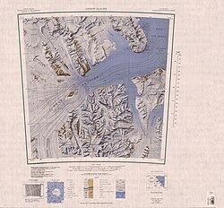
705:
699:
693:
687:
681:
670:
664:
643:
642:
640:
639:
638:
637:-82.933; 163.183
633:
629:
626:
625:
624:
621:
605:
604:
602:
601:
600:
599:-82.883; 163.000
595:
591:
588:
587:
586:
583:
563:
562:
560:
559:
558:
557:-82.883; 162.600
553:
549:
546:
545:
544:
541:
517:
516:
514:
513:
512:
511:-82.967; 161.633
507:
503:
500:
499:
498:
495:
475:
474:
472:
471:
470:
469:-82.867; 160.933
465:
461:
458:
457:
456:
453:
433:
432:
430:
429:
428:
427:-82.817; 161.317
423:
419:
416:
415:
414:
411:
387:
386:
384:
383:
382:
381:-82.933; 161.167
377:
373:
370:
369:
368:
365:
264:Clements Markham
241:
240:
238:
237:
236:
234:
229:
228:
227:-82.850; 161.350
223:
218:
215:
214:
213:
210:
187:
174:Shackleton Coast
160:
159:
157:
156:
155:
153:
148:
147:
146:-82.850; 161.350
142:
137:
134:
133:
132:
129:
65:Shackleton Coast
54:
53:
47:
30:
21:
904:
903:
899:
898:
897:
895:
894:
893:
869:
868:
867:
852:
844:
842:
835:
827:
825:
817:
802:
796:
794:
790:
783:
779:
774:
766:
762:
754:
750:
742:
738:
730:
726:
718:
714:
706:
702:
694:
690:
682:
673:
665:
658:
654:
636:
634:
630:
627:
622:
619:
617:
615:
614:
612:
598:
596:
592:
589:
584:
581:
579:
577:
576:
574:
556:
554:
550:
547:
542:
539:
537:
535:
534:
532:
522:, 1963-64, and
520:McMurdo Station
510:
508:
504:
501:
496:
493:
491:
489:
488:
486:
468:
466:
462:
459:
454:
451:
449:
447:
446:
444:
426:
424:
420:
417:
412:
409:
407:
405:
404:
402:
380:
378:
374:
371:
366:
363:
361:
359:
358:
356:
354:Markham Plateau
351:
349:Nearby features
323:
322:
321:
320:
319:
280:
274:as its leader.
256:
232:
230:
226:
224:
220:
219:
216:
211:
208:
206:
204:
203:
185:
151:
149:
145:
143:
139:
138:
135:
130:
127:
125:
123:
122:
75:
74:
73:
72:
71:
62:
61:
60:
59:
55:
28:
23:
22:
18:Markham Plateau
15:
12:
11:
5:
902:
900:
892:
891:
886:
881:
871:
870:
866:
865:
849:
838:Nimrod Glacier
833:
815:
780:
778:
775:
773:
772:
770:, p. 588.
760:
758:, p. 736.
748:
746:, p. 319.
736:
734:, p. 384.
724:
722:, p. 402.
712:
710:, p. 450.
700:
688:
686:, p. 462.
671:
655:
653:
650:
646:Pavlak Glacier
611:
610:Mount Predoehl
608:
573:
570:
531:
528:
485:
482:
443:
440:
401:
398:
355:
352:
350:
347:
337:, east of the
318:
317:
312:
307:
302:
296:
290:
283:
282:
281:
279:
276:
255:
252:
195:
194:
189:
181:
180:
171:
167:
166:
162:
161:
120:
114:
113:
108:
102:
101:
98:
92:
91:
88:
82:
81:
77:
76:
63:
57:
56:
49:
48:
42:
41:
40:
39:
38:
35:
34:
26:
24:
14:
13:
10:
9:
6:
4:
3:
2:
901:
890:
887:
885:
882:
880:
877:
876:
874:
863:
859:
850:
840:
839:
834:
824:
820:
816:
813:
809:
789:
788:
782:
781:
776:
769:
764:
761:
757:
752:
749:
745:
740:
737:
733:
728:
725:
721:
716:
713:
709:
704:
701:
697:
692:
689:
685:
680:
678:
676:
672:
668:
663:
661:
657:
651:
649:
647:
641:
609:
607:
603:
571:
569:
567:
566:McMurdo Sound
561:
529:
527:
525:
521:
515:
483:
481:
479:
473:
441:
439:
437:
431:
400:Mount Lysaght
399:
397:
395:
391:
385:
353:
348:
346:
344:
340:
339:Frigate Range
336:
327:
316:
313:
311:
308:
306:
303:
301:
298:
297:
295:
294:
289:
288:OpenStreetMap
286:
277:
275:
273:
269:
265:
261:
253:
251:
249:
245:
239:
233:Mount Markham
201:
200:Mount Markham
193:
190:
188:
182:
179:
175:
172:
168:
163:
158:
152:Mount Markham
121:
119:
115:
112:
109:
107:
103:
99:
97:
93:
89:
87:
83:
78:
70:
66:
58:Mount Markham
46:
36:
33:Mount Markham
31:
19:
843:, retrieved
837:
826:. Retrieved
823:peaklist.org
822:
795:, retrieved
786:
768:Alberts 1995
763:
756:Alberts 1995
751:
744:Alberts 1995
739:
732:Alberts 1995
727:
720:Alberts 1995
715:
708:Alberts 1995
703:
691:
684:Alberts 1995
613:
575:
572:Mount Tedrow
533:
524:Byrd Station
487:
445:
442:Mount Korsch
403:
357:
343:Kent Glacier
332:
292:
291:
284:
257:
199:
198:
186:Parent range
635: /
597: /
555: /
509: /
467: /
425: /
379: /
225: /
144: /
118:Coordinates
873:Categories
845:2024-01-03
828:2011-12-24
797:2023-12-03
652:References
530:Haven Hill
335:Mount Cara
231: (
178:Antarctica
150: (
96:Prominence
69:Antarctica
165:Geography
86:Elevation
623:163°11′E
585:163°00′E
568:, 1960.
543:162°36′E
497:161°38′E
455:160°56′E
413:161°19′E
367:161°10′E
278:Location
212:161°21′E
170:Location
131:161°21′E
777:Sources
620:82°56′S
582:82°53′S
540:82°53′S
494:82°58′S
452:82°52′S
410:82°49′S
364:82°56′S
209:82°51′S
128:82°51′S
106:Listing
244:massif
791:(PDF)
111:Ultra
300:KML
875::
821:.
674:^
659:^
438:.
176:,
67:,
864:.
831:.
814:.
698:.
669:.
235:)
202:(
154:)
20:)
Text is available under the Creative Commons Attribution-ShareAlike License. Additional terms may apply.