221:
214:
343:(kW·h) per year (15 MW·yr/yr). The wind turbines are assembled in multiple parts. The towers, which are composed of three support sections stacked one on top of another with a combined weight of 20,000 pounds, are 262 ft (80 m) tall. The three blades (together, a rotor) attached to the hub of the turbine each span approximately 115 ft (37.5 m), for a rotor diameter of approximately 250 feet — comparable to the
25:
312:
131:
298:
By virtue of its height and
Northeast location, the summit of Mars Hill is the first place in the contiguous United States to see the Sun rise for nearly half of the year, from March 25 to September 18. The first
834:
914:
945:
694:
476:
909:
879:
584:
639:
614:
689:
609:
170:
849:
829:
854:
213:
42:
108:
511:
254:
89:
46:
61:
303:
to see the Sun in the U.S. was raised on July 4, 1960, at 4:33 AM. Fifty national guardsmen gave it a 50-gun salute.
940:
629:
501:
163:
68:
935:
469:
462:
669:
485:
363:
291:
is visible from the top of Mars Hill over 85 miles (135 km) away. Mars Hill also has a ski area, called
844:
528:
300:
75:
674:
659:
284:
434:
904:
899:
764:
679:
654:
543:
233:
57:
35:
864:
804:
649:
624:
153:
749:
744:
734:
699:
548:
292:
599:
493:
449:
399:
894:
704:
589:
368:
869:
839:
754:
719:
709:
644:
619:
604:
594:
538:
533:
889:
824:
809:
634:
564:
82:
884:
874:
814:
724:
328:
273:
819:
779:
336:
249:
784:
794:
769:
729:
684:
520:
288:
929:
859:
799:
340:
283:
The mountain plays an important role in the Mars Hill community, and overlooks the
789:
774:
714:
664:
24:
439:
311:
130:
351:
324:
320:
185:
172:
759:
344:
332:
269:
387:
454:
435:
U.S. Geological Survey
Geographic Names Information System: Mars Hill
348:
335:
turbines along the top and northern sections of the mountain. With a
143:
310:
277:
237:
458:
18:
411:
444:
339:
of 35%, the wind farm generates about 130 million
577:
557:
519:
510:
492:
248:
201:
162:
152:
142:
137:
123:
49:. Unsourced material may be challenged and removed.
315:Mars Hill in late winter as seen from US Highway 1
470:
8:
516:
477:
463:
455:
120:
109:Learn how and when to remove this message
835:Saddleback Mountain (Piscataquis County)
915:White Cap Mountain (Piscataquis County)
380:
695:Elephant Mountain (Piscataquis County)
830:Saddleback Mountain (Franklin County)
7:
946:Landforms of Aroostook County, Maine
910:White Cap Mountain (Franklin County)
319:Mars Hill underwent an $ 85 million
47:adding citations to reliable sources
390:elevation between 530 and 540 feet.
400:Talk:Maine/Archive 1#First Sunrise
14:
690:Elephant Mountain (Oxford County)
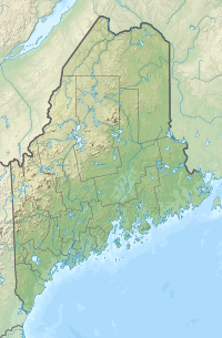
287:, in which Mars Hill is located.
220:
450:slideshow of Mars Hill Wind Farm
219:
212:
129:
23:
16:Mountain in Maine, United States
850:Snow Mountain (Franklin County)
34:needs additional citations for
323:project in the fall of 2006.
280:, and gave the town its name.
1:
855:Snow Mountain (Oxford County)
962:
445:Mars Hill Wind Farm Webcam
364:List of mountains in Maine
158:1,210 ft (370 m)
148:1,748 ft (533 m)
440:peakbagger.com: Mars Hill
206:
128:
905:Western Maine Mountains
900:West Kennebago Mountain
680:East Kennebago Mountain
865:South Crocker Mountain
625:Boundary Bald Mountain
316:
58:"Mars Hill" Maine
549:Sunday River Whitecap
412:"Mars Hill Wind Farm"
314:
186:46.52111°N 67.81361°W
600:Big Spencer Mountain
494:Longfellow Mountains
43:improve this article
941:Wind farms in Maine
895:Tumbledown Mountain
705:Great Pond Mountain
590:Bauneg Beg Mountain
369:Wind power in Maine
191:46.52111; -67.81361
182: /
936:Mountains of Maine
880:Sugarloaf Mountain
870:Spaulding Mountain
840:Sandy Bay Mountain
710:Greenwood Mountain
670:Doubletop Mountain
645:Catherine Mountain
620:Borestone Mountain
615:Blueberry Mountain
605:Black Cap Mountain
595:Big Moose Mountain
539:Old Speck Mountain
534:Goose Eye Mountain
486:Mountains of Maine
327:installed 28
317:
138:Highest point
923:
922:
890:Traveler Mountain
845:Shutdown Mountain
825:Saddleback Junior
810:Pleasant Mountain
635:Cadillac Mountain
630:Bradbury Mountain
573:
572:
565:Speckled Mountain
529:Baldpate Mountain
293:Big Rock Ski Area
285:Saint John Valley
263:
262:
119:
118:
111:
93:
953:
885:Titcomb Mountain
875:Stetson Mountain
815:Rollins Mountain
725:Kennebago Divide
675:Douglas Mountain
660:Crocker Mountain
640:Caribou Mountain
517:
479:
472:
465:
456:
422:
421:
419:
418:
408:
402:
397:
391:
385:
329:General Electric
234:Aroostook County
223:
222:
216:
197:
196:
194:
193:
192:
187:
183:
180:
179:
178:
175:
133:
121:
114:
107:
103:
100:
94:
92:
51:
27:
19:
961:
960:
956:
955:
954:
952:
951:
950:
926:
925:
924:
919:
820:Saddleback Horn
780:Mount Redington
765:Mount Jefferson
655:Coburn Mountain
569:
553:
544:Puzzle Mountain
512:White Mountains
506:
488:
483:
431:
426:
425:
416:
414:
410:
409:
405:
398:
394:
386:
382:
377:
360:
337:capacity factor
309:
244:
243:
242:
241:
240:
231:
230:
229:
228:
224:
190:
188:
184:
181:
176:
173:
171:
169:
168:
115:
104:
98:
95:
52:
50:
40:
28:
17:
12:
11:
5:
959:
957:
949:
948:
943:
938:
928:
927:
921:
920:
918:
917:
912:
907:
902:
897:
892:
887:
882:
877:
872:
867:
862:
857:
852:
847:
842:
837:
832:
827:
822:
817:
812:
807:
805:Noyes Mountain
802:
797:
795:Moxie Mountain
792:
787:
782:
777:
772:
770:Mount Katahdin
767:
762:
757:
752:
747:
742:
737:
732:
730:Kibby Mountain
727:
722:
717:
712:
707:
702:
697:
692:
687:
685:Eaton Mountain
682:
677:
672:
667:
662:
657:
652:
650:Clark Mountain
647:
642:
637:
632:
627:
622:
617:
612:
607:
602:
597:
592:
587:
585:Baker Mountain
581:
579:
575:
574:
571:
570:
568:
567:
561:
559:
555:
554:
552:
551:
546:
541:
536:
531:
525:
523:
521:Mahoosuc Range
514:
508:
507:
505:
504:
498:
496:
490:
489:
484:
482:
481:
474:
467:
459:
453:
452:
447:
442:
437:
430:
429:External links
427:
424:
423:
403:
392:
379:
378:
376:
373:
372:
371:
366:
359:
356:
341:kilowatt hours
308:
305:
289:Mount Katahdin
261:
260:
252:
246:
245:
232:
226:
225:
218:
217:
211:
210:
209:
208:
207:
204:
203:
199:
198:
166:
160:
159:
156:
150:
149:
146:
140:
139:
135:
134:
126:
125:
117:
116:
31:
29:
22:
15:
13:
10:
9:
6:
4:
3:
2:
958:
947:
944:
942:
939:
937:
934:
933:
931:
916:
913:
911:
908:
906:
903:
901:
898:
896:
893:
891:
888:
886:
883:
881:
878:
876:
873:
871:
868:
866:
863:
861:
860:South Brother
858:
856:
853:
851:
848:
846:
843:
841:
838:
836:
833:
831:
828:
826:
823:
821:
818:
816:
813:
811:
808:
806:
803:
801:
800:North Brother
798:
796:
793:
791:
788:
786:
783:
781:
778:
776:
773:
771:
768:
766:
763:
761:
758:
756:
753:
751:
750:Mount Bigelow
748:
746:
745:Mount Abraham
743:
741:
738:
736:
735:Lead Mountain
733:
731:
728:
726:
723:
721:
718:
716:
713:
711:
708:
706:
703:
701:
700:Fort Mountain
698:
696:
693:
691:
688:
686:
683:
681:
678:
676:
673:
671:
668:
666:
663:
661:
658:
656:
653:
651:
648:
646:
643:
641:
638:
636:
633:
631:
628:
626:
623:
621:
618:
616:
613:
611:
608:
606:
603:
601:
598:
596:
593:
591:
588:
586:
583:
582:
580:
576:
566:
563:
562:
560:
556:
550:
547:
545:
542:
540:
537:
535:
532:
530:
527:
526:
524:
522:
518:
515:
513:
509:
503:
502:Boundary Peak
500:
499:
497:
495:
491:
487:
480:
475:
473:
468:
466:
461:
460:
457:
451:
448:
446:
443:
441:
438:
436:
433:
432:
428:
413:
407:
404:
401:
396:
393:
389:
384:
381:
374:
370:
367:
365:
362:
361:
357:
355:
353:
350:
346:
342:
338:
334:
330:
326:
322:
313:
306:
304:
302:
296:
294:
290:
286:
281:
279:
275:
271:
267:
259:
256:
253:
251:
247:
239:
235:
215:
205:
200:
195:
167:
165:
161:
157:
155:
151:
147:
145:
141:
136:
132:
127:
122:
113:
110:
102:
91:
88:
84:
81:
77:
74:
70:
67:
63:
60: –
59:
55:
54:Find sources:
48:
44:
38:
37:
32:This article
30:
26:
21:
20:
785:Mount Tire'm
739:
610:Black Nubble
415:. Retrieved
406:
395:
383:
318:
301:50-star flag
297:
282:
265:
264:
257:
105:
96:
86:
79:
72:
65:
53:
41:Please help
36:verification
33:
790:Mount Waldo
775:Mount Kineo
715:Hamlin Peak
665:Crotch Hill
354:jet-liner.
272:located in
189: /
164:Coordinates
930:Categories
755:Mount Blue
720:High Peaks
417:2009-01-29
325:First Wind
321:wind power
177:67°48′49″W
174:46°31′16″N
154:Prominence
69:newspapers
760:Mount Coe
740:Mars Hill
331:1.5
307:Wind farm
274:Mars Hill
266:Mars Hill
258:Mars Hill
227:Mars Hill
202:Geography
144:Elevation
124:Mars Hill
99:July 2013
358:See also
345:wingspan
333:megawatt
270:mountain
250:Topo map
388:Key col
83:scholar
578:Others
558:Others
349:Boeing
85:
78:
71:
64:
56:
375:Notes
347:of a
278:Maine
268:is a
238:Maine
90:JSTOR
76:books
255:USGS
62:news
352:747
45:by
932::
295:.
276:,
236:,
478:e
471:t
464:v
420:.
112:)
106:(
101:)
97:(
87:·
80:·
73:·
66:·
39:.
Text is available under the Creative Commons Attribution-ShareAlike License. Additional terms may apply.