352:. MD 503 was constructed as a gravel road in 1933. The Drum Point portion of MD 760 was constructed as a county highway by 1938 to provide access to the M.M. Davis Shipyard, a leading producer of yachts that was sited on Ship Point opposite Solomons at the mouth of Mill Creek in 1913. The road to the Davis Shipyard and the portion of MD 503 north to MD 2 was improved as a wartime access project in around 1944. MD 503 was removed from the state highway system in 1957. MD 760 was assigned in two sections: along Rousby Hall Road from the present southern terminus to Olivet Road in 1962, and from there north to MD 2 in 1963. The state highway was extended north to MD 2/MD 4 when the two highways were relocated from MD 765 to a new divided highway to the west around 1987; this intersection was changed to a directional crossover intersection in 2005. The roundabout at Olivet Road was constructed in 2006 in conjunction with the fourth leg of the roundabout, Southern Connector Boulevard.
308:
26:
437:
244:
229:
99:
464:
459:
123:
118:
505:
347:
MD 760's predecessor state highway was MD 503, which was assigned to the highway from MD 2 (now MD 765) in Lusby to the southern end of Olivet Road in community of Olivet on the peninsula between St. John Creek and Mill Creek. The portion of MD 760 in Drum Point was preceded by a series of streets,
572:
307:
299:. The portion of MD 760 in Lusby was built as MD 503 in the early 1930s; the Drum Point section was constructed as a county highway by 1939. MD 503 was removed from the state highway system in the late 1950s. MD 760 was designated in two sections in the early 1960s.
323:. The state highway heads east and then northeast as a two-lane undivided road through the community of Drum Point. MD 760 curves north as it passes along the western edge of
709:
327:
and crosses Coles Creek. The state highway turns west and crosses Mill Creek into Lusby, where the highway meets Olivet Road and
Southern Connector Boulevard at a
983:
834:
814:
794:
774:
666:
599:
961:
197:
335:(H.G. Trueman Road) in a commercial area before reaching its northern terminus at a directional crossover intersection with MD 2/MD 4, which
53:
978:
324:
207:
202:
212:
618:
479:
361:
170:
189:
509:
893:
854:
534:
391:
284:
85:
703:
475:
440:
336:
332:
316:
247:
232:
102:
623:(Map) (1905 ed.). 1:48,000. 15 Minute Series (Topographic). United States Geological Survey
668:
Map of
Maryland Showing State Road System: State Aid Roads and Improved County Road Connections
952:
471:
467:
349:
292:
288:
130:
126:
910:
871:
551:
410:
296:
106:
750:
686:
642:
320:
972:
268:
150:
933:
577:
311:
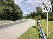
View south along MD 760 at Olivet Road and
Southern Connector Boulevard in Lusby
328:
272:
724:
647:(1931–1934 ed.). Baltimore: Maryland State Roads Commission. p. 322
755:(1943–1944 ed.). Baltimore: Maryland State Roads Commission. p. 95
691:(1937–1938 ed.). Baltimore: Maryland State Roads Commission. p. 24
685:
Beall, J. Glenn; Jarboe, Elmer R.; Obrecht, George F., Sr. (March 4, 1939).
25:
276:
160:
283:, the state highway runs 4.56 miles (7.34 km) from Rousby Road in
749:
Whitman, Ezra B.; Webb, P. Watson; Thomas, W. Frank (March 1, 1945).
348:
now part of residential subdivisions, that connected Lusby with the
306:
960:
489:
1.000 mi = 1.609 km; 1.000 km = 0.621 mi
892:
Highway
Information Services Division (December 31, 2006).
853:
Highway
Information Services Division (December 31, 2005).
533:
Highway
Information Services Division (December 31, 2013).
842:(Map). Baltimore: Maryland State Highway Administration.
331:, from which MD 760 continues north. MD 760 intersects
315:
MD 760 begins at Rousby Road on a peninsula adjacent to
948:
943:
641:
Byron, William D.; Lacy, Robert (December 28, 1934).
421:
Olivet Road south / Southern
Connector Boulevard west
180:
166:
156:
146:
141:
112:
91:
80:
75:
67:
59:
46:
21:
822:(Map). Baltimore: Maryland State Roads Commission.
802:(Map). Baltimore: Maryland State Roads Commission.
782:(Map). Baltimore: Maryland State Roads Commission.
607:(Map). Baltimore: Maryland State Roads Commission.
752:Report of the State Roads Commission of Maryland
688:Report of the State Roads Commission of Maryland
644:Report of the State Roads Commission of Maryland
833:Maryland State Highway Administration (1987).
528:
526:
524:
674:(Map). Baltimore: Maryland Geological Survey.
8:
708:: CS1 maint: multiple names: authors list (
366:
221:
965:
962:Template:Attached KML/Maryland Route 760
813:Maryland State Roads Commission (1963).
793:Maryland State Roads Commission (1962).
773:Maryland State Roads Commission (1957).
598:Maryland State Roads Commission (1939).
16:State highway in Maryland, United States
898:. Maryland State Highway Administration
859:. Maryland State Highway Administration
539:. Maryland State Highway Administration
520:
701:
601:General Highway Map: State of Maryland
18:
456:
450:
434:
428:
420:
414:
401:
395:
7:
665:Maryland Geological Survey (1933).
378:
14:
984:Roads in Calvert County, Maryland
503:
462:
457:
435:
242:
227:
121:
116:
97:
63:4.56 mi (7.34 km)
24:
836:Maryland: Official Highway Map
816:Maryland: Official Highway Map
796:Maryland: Official Highway Map
776:Maryland: Official Highway Map
729:The Historical Marker Database
474:(Solomons Island Road) –
1:
731:. Springfield, VA: J.J. Prats
373:
725:"M.M. Davis Shipyard Marker"
1000:
979:State highways in Maryland
895:Highway Location Reference
856:Highway Location Reference
536:Highway Location Reference
620:Drum Point, MD quadrangle
510:Maryland Roads portal
488:
483:
453:
445:
431:
423:
417:
409:
404:
398:
390:
385:
382:
377:
372:
369:
339:as Solomons Island Road.
220:
185:
176:
137:
51:
42:
37:
723:Robby, F. (2007-11-11).
325:Chesapeake Ranch Estates
360:The entire route is in
190:Maryland highway system
312:
319:and the mouth of the
310:
966:KML is from Wikidata
573:"Maryland Route 760"
443:(H.G. Trueman Road)
93:Major intersections
446:Officially MD 765Q
313:
261:Maryland Route 760
31:Maryland Route 760
494:
493:
484:Northern terminus
405:Southern terminus
303:Route description
258:
257:
254:
253:
47:Route information
991:
956:
922:
919:
917:
906:
904:
903:
889:
883:
880:
878:
867:
865:
864:
850:
844:
843:
841:
830:
824:
823:
821:
810:
804:
803:
801:
790:
784:
783:
781:
770:
764:
763:
761:
760:
746:
740:
739:
737:
736:
720:
714:
713:
707:
699:
697:
696:
682:
676:
675:
673:
662:
656:
655:
653:
652:
638:
632:
631:
629:
628:
615:
609:
608:
606:
595:
589:
588:
586:
585:
569:
563:
560:
558:
547:
545:
544:
530:
508:
507:
506:
480:Prince Frederick
466:
465:
461:
460:
439:
438:
402:Rousby Road west
380:
375:
367:
350:Drum Point Light
337:run concurrently
281:Rousby Hall Road
250:
246:
245:
235:
231:
230:
222:
125:
124:
120:
119:
101:
100:
94:
38:Rousby Hall Road
28:
19:
999:
998:
994:
993:
992:
990:
989:
988:
969:
968:
967:
964:
959:
958:
957:
941:
934:MDRoads: MD 760
930:
925:
915:
909:
901:
899:
891:
890:
886:
876:
870:
862:
860:
852:
851:
847:
839:
832:
831:
827:
819:
812:
811:
807:
799:
792:
791:
787:
779:
772:
771:
767:
758:
756:
748:
747:
743:
734:
732:
722:
721:
717:
700:
694:
692:
684:
683:
679:
671:
664:
663:
659:
650:
648:
640:
639:
635:
626:
624:
617:
616:
612:
604:
597:
596:
592:
583:
581:
571:
570:
566:
556:
550:
542:
540:
532:
531:
522:
518:
504:
502:
499:
490:
463:
458:
436:
358:
345:
317:Solomons Island
305:
243:
241:
228:
226:
122:
117:
98:
92:
84:Rousby Road in
76:Major junctions
33:
32:
29:
17:
12:
11:
5:
997:
995:
987:
986:
981:
971:
970:
940:
939:
938:
937:
936:
929:
928:External links
926:
924:
923:
921:
920:
912:Calvert County
884:
882:
881:
873:Calvert County
845:
825:
805:
785:
765:
741:
715:
677:
657:
633:
610:
590:
564:
562:
561:
553:Calvert County
519:
517:
514:
513:
512:
498:
495:
492:
491:
486:
485:
482:
455:
452:
448:
447:
444:
433:
430:
426:
425:
422:
419:
416:
413:
407:
406:
403:
400:
397:
394:
388:
387:
384:
381:
376:
371:
362:Calvert County
357:
354:
344:
341:
321:Patuxent River
304:
301:
256:
255:
252:
251:
238:
236:
218:
217:
216:
215:
210:
205:
200:
194:
193:
183:
182:
181:Highway system
178:
177:
174:
173:
168:
164:
163:
158:
154:
153:
148:
144:
143:
139:
138:
135:
134:
114:
113:North end
110:
109:
95:
89:
88:
82:
81:South end
78:
77:
73:
72:
69:
65:
64:
61:
57:
56:
52:Maintained by
49:
48:
44:
43:
40:
39:
35:
34:
30:
23:
22:
15:
13:
10:
9:
6:
4:
3:
2:
996:
985:
982:
980:
977:
976:
974:
963:
954:
950:
946:
945:
935:
932:
931:
927:
914:
913:
908:
907:
897:
896:
888:
885:
875:
874:
869:
868:
858:
857:
849:
846:
838:
837:
829:
826:
818:
817:
809:
806:
798:
797:
789:
786:
778:
777:
769:
766:
754:
753:
745:
742:
730:
726:
719:
716:
711:
705:
690:
689:
681:
678:
670:
669:
661:
658:
646:
645:
637:
634:
622:
621:
614:
611:
603:
602:
594:
591:
580:
579:
574:
568:
565:
555:
554:
549:
548:
538:
537:
529:
527:
525:
521:
515:
511:
501:
500:
496:
487:
481:
477:
473:
469:
449:
442:
427:
412:
408:
393:
389:
368:
365:
363:
356:Junction list
355:
353:
351:
342:
340:
338:
334:
330:
326:
322:
318:
309:
302:
300:
298:
294:
290:
286:
282:
278:
274:
270:
269:state highway
266:
262:
249:
239:
237:
234:
224:
223:
219:
214:
213:Scenic Byways
211:
209:
206:
204:
201:
199:
196:
195:
192:
191:
187:
186:
184:
179:
175:
172:
169:
165:
162:
159:
155:
152:
151:United States
149:
145:
140:
136:
132:
128:
115:
111:
108:
104:
96:
90:
87:
83:
79:
74:
70:
66:
62:
58:
55:
50:
45:
41:
36:
27:
20:
942:
911:
900:. Retrieved
894:
887:
872:
861:. Retrieved
855:
848:
835:
828:
815:
808:
795:
788:
775:
768:
757:. Retrieved
751:
744:
733:. Retrieved
728:
718:
693:. Retrieved
687:
680:
667:
660:
649:. Retrieved
643:
636:
625:. Retrieved
619:
613:
600:
593:
582:. Retrieved
576:
567:
552:
541:. Retrieved
535:
383:Destinations
359:
346:
314:
280:
279:. Known as
264:
260:
259:
188:
71:1962–present
578:Google Maps
973:Categories
902:2011-02-21
863:2011-02-21
759:2011-02-21
735:2011-02-21
695:2011-02-23
651:2011-02-21
627:2011-02-21
584:2010-08-03
543:2011-02-18
516:References
424:Roundabout
392:Drum Point
329:roundabout
285:Drum Point
273:U.S. state
198:Interstate
86:Drum Point
704:cite book
287:north to
944:KML file
497:See also
476:Solomons
470: /
370:Location
277:Maryland
167:Counties
161:Maryland
142:Location
133:in Lusby
129: /
575:(Map).
343:History
271:in the
267:) is a
171:Calvert
147:Country
68:Existed
441:MD 765
333:MD 765
265:MD 760
248:MD 761
233:MD 759
103:MD 765
60:Length
916:(PDF)
877:(PDF)
840:(PDF)
820:(PDF)
800:(PDF)
780:(PDF)
672:(PDF)
605:(PDF)
557:(PDF)
411:Lusby
386:Notes
297:Lusby
208:State
157:State
107:Lusby
54:MDSHA
953:help
949:edit
710:link
472:MD 4
468:MD 2
454:7.48
451:4.65
432:7.05
429:4.38
418:5.10
415:3.17
399:0.00
396:0.00
293:MD 4
289:MD 2
131:MD 4
127:MD 2
295:in
275:of
105:in
975::
951:•
727:.
706:}}
702:{{
523:^
478:,
379:km
374:mi
364:.
240:→
225:←
203:US
955:)
947:(
918:.
905:.
879:.
866:.
762:.
738:.
712:)
698:.
654:.
630:.
587:.
559:.
546:.
291:/
263:(
Text is available under the Creative Commons Attribution-ShareAlike License. Additional terms may apply.