695:. A broad glacier tongue extending eastward from the Mawson Glacier into the Ross Sea. Discovered by the BrNAE (1901-04) and named for Otto Nordenskjold, Swedish geographer who led an expedition to Antarctica in 1901. This feature had become well established by the name Nordenskjold Ice Tongue prior to initiation of systematic application of common specific names to a glacier and its glacier tongue. Although this feature is a glacier tongue, the generic term ice tongue is retained in the name to reduce ambiguity.
28:
264:
256:
657:. A cape on the coast of Victoria Land 3 nautical miles (5.6 km; 3.5 mi) north of Cape Day. The cape is marked by a rock exposure and is situated at the south side of the terminus of Mawson Glacier. Mapped by USGS from surveys and U.S Navy aerial photographs, 1957-61. Named by US-ACAN for Joseph R. Cornely, USN, radioman with the wintering parties at Little America V, South Pole Station, and McMurdo Station in three years, 1958, 1961 and 1963.
619:. Cape on the coast of Victoria Land, just east of Charcot Cove and Marin Glacier. It forms the outer, north portal of the re-entrant through which Mawson Glacier flows to the Ross Sea. Mapped by USGS from ground surveys and Navy air photos. Named by US-ACAN in 1964 for Lt. John Hickey, USN, pilot with Navy Squadron VX-6, who participated in Topo North and South surveys in 1962.
386:. A moraine located 8 nautical miles (15 km; 9.2 mi) west of Reckling Peak, the latter at the head of Mawson Glacier. The site of the moraine is part of a long, narrow patch of bare ice that extends west from Reckling Peak, from which the moraine is named. The name arose following the collection of meteorites at the moraine by a USARP field party in the 1979-80 season.
35:
1021:
1343:
348:. An isolated peak, 2,010 metres (6,590 ft) high, which surmounts the central part of a ridge located at the icefalls at the head of Mawson Glacier. Mapped by USGS from ground surveys and Navy air photos. Named by US-ACAN in 1964 for Lt. Commander Darold L. Reckling, pilot with U.S. Navy Squadron VX-6, 1961.
183:
After the Last
Glacial Maximum (LGM) there was dynamic retreat of the ice sheet covering the Ross Sea in the Mawson Glacier region. The glacier thinned abruptly between 7,500 and 4,500 years ago, then thinned more gradually until recently. This thinning was very similar to what happened at the
462:. A large nunatak in the stream of the Mawson Glacier, about 5 nautical miles (9.3 km; 5.8 mi) north of the Convoy Range in Victoria Land. Mapped in 1957 by the New Zealand Northern Survey party of the CTAE (1956-58), which applied the name because of its three summits.
581:. A point situated at the south side of Charcot Cove on the coast of Victoria Land. Discovered by the BrNAE (1901-04) under Capt. Robert F. Scott, who named the feature for William S. Bruce, leader of the Scottish National Antarctic Expedition (1902-04).
424:. Nunatak lying 7 nautical miles (13 km; 8.1 mi) west-northwest of the main summit of Trinity Nunatak in the stream of the Mawson Glacier. Named by US-ACAN in 1964 for Lt. Commander Michael Jarina, pilot with U.S. Navy Squadron VX-6 in 1962.
543:. A glacier just west of Cape Hickey, flowing southeast into Charcot Cove on the coast of Victoria Land. Mapped by USGS from ground surveys and Navy air photos. Named by US-AC AN in 1964 for Bonifacio Marin, engineman at McMurdo Station, 1962.
310:. It is mostly ice free and has a number of small peaks running in a line west from the main peak. Discovered and named by the New Zealand party (1957-58) of the CTAE. The name describes the steep rock peaks of the nunatak.
1025:
505:. A re-entrant in the coast of Victoria Land between Bruce Point and Cape Hickey. Discovered by the BrNAE (1901-04) which named this feature for Dr. Jean B. Charcot, noted Arctic and Antarctic explorer.
1068:
Jones, R.S.; Whitmore, R.J.; Mackintosh, A.N.; Norton, K.P.; Eaves, S.R.; Stutz, J.; Christl, M. (2020), "Regional-scale abrupt Mid-Holocene ice sheet thinning in the western Ross Sea, Antarctica",
1219:
1269:
1189:
1184:
1110:
204:
to its south. It flows past
Charcot Cove and Bruce Point to the north and the Oates Piedmont Glacier and Cape Day to its south, to terminate in the NordenSkjold Ice Tongue.
196:
The Mawson
Glacier rises on the Antarctic Plateau. Features of the region of its head include Battlements Nunatak, Reckling Peak, Jarina Nunatak and Trinity Nunatak. The
1264:
1229:
1138:
1133:
1295:
1259:
1194:
1234:
200:
and
Chattahoochee Glacier flows into the head of the glacier. Mawson Glacier flows east past the Walker Rocks and Mount Murray to its north and the
1249:
1204:
1103:
1029:
65:
1244:
1239:
1209:
1363:
1169:
1154:
1096:
27:
1274:
1254:
1159:
1119:
787:. First charted by the BrAE (1907-09) which named this cape after Bernard C. Day, electrician and motor expert with the expedition.
1174:
188:
100 kilometres (62 mi) to the south. Probably the ice sheet retreat and glacial ice drawdown were caused by ocean warming.
1279:
1224:
1179:
1214:
1164:
123:
1310:
1305:
1199:
1333:
58:
741:
and Mawson
Glacier. Surveyed in 1957 and named by the N.Z. Northern Survey Party of the CTAE (1956-58) after Capt.
306:. A large nunatak near the head of Mawson Glacier, about 6 nautical miles (11 km; 6.9 mi) northwest of
755:
705:
667:
629:
591:
553:
515:
477:
434:
396:
358:
320:
278:
217:
1368:
244:
263:
742:
239:
745:
who, with
Captain Scott and three companions, perished on the return from the South Pole in 1912.
175:, the expedition physicist, who later led two other Antarctic expeditions, 1911–14, and 1929–31.
255:
234:
168:
156:
1347:
1315:
1077:
1052:
783:. A cape on the coast of Victoria Land 11 nautical miles (20 km; 13 mi) east of
1036:
734:
201:
185:
172:
160:
1357:
197:
152:
51:
1320:
1003:
167:, where it forms the Nordenskjöld Ice Tongue. The glacier was first mapped by the
784:
738:
307:
229:
770:
757:
720:
707:
682:
669:
644:
631:
606:
593:
568:
555:
530:
517:
492:
479:
449:
436:
411:
398:
373:
360:
335:
322:
293:
280:
138:
125:
80:
67:
1088:
1300:
164:
108:
1081:
262:
254:
1092:
814:
737:, occupying the whole of the coastal platform between the
861:
859:
1331:
1011:(2 ed.), United States Board on Geographic Names
1288:
1147:
1126:
104:
96:
57:
47:
838:
1104:
826:
8:
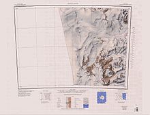
733:An extensive lowland ice sheet east of the
259:Upper section of the glacier (to the north)
155:, Antarctica, descending eastward from the
1296:List of Antarctic and subantarctic islands
1111:
1097:
1089:
151:) is a large glacier on the east coast of
100:35 nautical miles (65 km; 40 mi)
18:
159:to the north of Trinity Nunatak and the
1338:
1057:, USGS: United States Geological Survey
1041:, USGS: United States Geological Survey
1030:United States Board on Geographic Names
985:
973:
961:
949:
937:
925:
913:
901:
889:
877:
865:
850:
802:
795:
1139:List of glaciers in the Antarctic: I–Z
1134:List of glaciers in the Antarctic: A–H
34:
7:
1220:Palmer Archipelago and Graham Land
1028:from websites or documents of the
14:
1270:Trinity Peninsula and Graham Land
1190:James Ross Island and Graham Land
1185:Heard Island and McDonald Islands
1005:Geographic Names of the Antarctic
1341:
1024: This article incorporates
1019:
267:Lower section (to the northwest)
33:
26:
1002:Alberts, Fred G., ed. (1995),
1:
1321:List of subantarctic glaciers
1311:List of Antarctic ice streams
1306:List of Antarctic ice shelves
169:British Antarctic Expedition
1301:List of Antarctic ice rises
245:GPX (secondary coordinates)
1385:
1364:Glaciers of Victoria Land
1120:Glaciers in the Antarctic
240:GPX (primary coordinates)
215:Map all coordinates using
21:
223:Download coordinates as:
171:(1907–09) and named for
1230:Princess Elizabeth Land
661:Nordenskjöld Ice Tongue
1260:South Shetland Islands
1195:Kaiser Wilhelm II Land
1026:public domain material
699:Oates Piedmont Glacier
268:
260:
266:
258:
235:GPX (all coordinates)
16:Glacier in Antarctica
1265:South Orkney Islands
1235:Queen Elizabeth Land
839:Franklin Island USGS
1205:Mac. Robertson Land
767: /
743:Lawrence E.G. Oates
717: /
679: /
641: /
603: /
565: /
527: /
489: /
446: /
408: /
370: /
332: /
290: /
272:Battlements Nunatak
135: /
77: /
771:76.300°S 162.767°E
721:76.417°S 162.583°E
683:76.183°S 162.750°E
645:76.233°S 162.750°E
607:76.083°S 162.633°E
569:76.133°S 162.433°E
531:76.067°S 162.367°E
493:76.117°S 162.400°E
450:76.433°S 160.633°E
412:76.383°S 160.167°E
374:76.250°S 158.667°E
336:76.267°S 159.250°E
294:76.533°S 159.350°E
269:
261:
139:76.217°S 162.083°E
81:76.217°S 162.083°E
1329:
1328:
827:Convoy Range USGS
815:Jones et al. 2020
157:Antarctic Plateau
114:
113:
1376:
1346:
1345:
1344:
1337:
1316:List of glaciers
1113:
1106:
1099:
1090:
1084:
1082:10.1130/G48347.1
1064:
1063:
1062:
1048:
1047:
1046:
1023:
1022:
1018:
1017:
1016:
1010:
989:
983:
977:
971:
965:
959:
953:
947:
941:
935:
929:
923:
917:
911:
905:
899:
893:
887:
881:
875:
869:
863:
854:
848:
842:
836:
830:
824:
818:
812:
806:
800:
782:
781:
779:
778:
777:
776:-76.300; 162.767
772:
768:
765:
764:
763:
760:
732:
731:
729:
728:
727:
726:-76.417; 162.583
722:
718:
715:
714:
713:
710:
694:
693:
691:
690:
689:
688:-76.183; 162.750
684:
680:
677:
676:
675:
672:
656:
655:
653:
652:
651:
650:-76.233; 162.750
646:
642:
639:
638:
637:
634:
618:
617:
615:
614:
613:
612:-76.083; 162.633
608:
604:
601:
600:
599:
596:
580:
579:
577:
576:
575:
574:-76.133; 162.433
570:
566:
563:
562:
561:
558:
542:
541:
539:
538:
537:
536:-76.067; 162.367
532:
528:
525:
524:
523:
520:
504:
503:
501:
500:
499:
498:-76.117; 162.400
494:
490:
487:
486:
485:
482:
461:
460:
458:
457:
456:
455:-76.433; 160.633
451:
447:
444:
443:
442:
439:
423:
422:
420:
419:
418:
417:-76.383; 160.167
413:
409:
406:
405:
404:
401:
385:
384:
382:
381:
380:
379:-76.250; 158.667
375:
371:
368:
367:
366:
363:
352:Reckling Moraine
347:
346:
344:
343:
342:
341:-76.267; 159.250
337:
333:
330:
329:
328:
325:
305:
304:
302:
301:
300:
299:-76.533; 159.350
295:
291:
288:
287:
286:
283:
150:
149:
147:
146:
145:
144:-76.217; 162.083
140:
136:
133:
132:
131:
128:
92:
91:
89:
88:
87:
86:-76.217; 162.083
82:
78:
75:
74:
73:
70:
37:
36:
30:
19:
1384:
1383:
1379:
1378:
1377:
1375:
1374:
1373:
1354:
1353:
1352:
1342:
1340:
1332:
1330:
1325:
1284:
1250:Ross Dependency
1245:Queen Maud Land
1240:Queen Mary Land
1210:Marie Byrd Land
1143:
1122:
1117:
1087:
1067:
1060:
1058:
1054:Franklin Island
1051:
1044:
1042:
1035:
1020:
1014:
1012:
1008:
1001:
997:
992:
984:
980:
972:
968:
960:
956:
948:
944:
936:
932:
924:
920:
912:
908:
900:
896:
888:
884:
876:
872:
864:
857:
849:
845:
837:
833:
825:
821:
813:
809:
801:
797:
793:
775:
773:
769:
766:
761:
758:
756:
754:
753:
751:
725:
723:
719:
716:
711:
708:
706:
704:
703:
701:
687:
685:
681:
678:
673:
670:
668:
666:
665:
663:
649:
647:
643:
640:
635:
632:
630:
628:
627:
625:
611:
609:
605:
602:
597:
594:
592:
590:
589:
587:
573:
571:
567:
564:
559:
556:
554:
552:
551:
549:
535:
533:
529:
526:
521:
518:
516:
514:
513:
511:
497:
495:
491:
488:
483:
480:
478:
476:
475:
473:
468:
454:
452:
448:
445:
440:
437:
435:
433:
432:
430:
428:Trinity Nunatak
416:
414:
410:
407:
402:
399:
397:
395:
394:
392:
378:
376:
372:
369:
364:
361:
359:
357:
356:
354:
340:
338:
334:
331:
326:
323:
321:
319:
318:
316:
298:
296:
292:
289:
284:
281:
279:
277:
276:
274:
253:
252:
251:
250:
249:
210:
194:
181:
163:, to enter the
143:
141:
137:
134:
129:
126:
124:
122:
121:
85:
83:
79:
76:
71:
68:
66:
64:
63:
43:
42:
41:
40:
39:
38:
17:
12:
11:
5:
1382:
1380:
1372:
1371:
1366:
1356:
1355:
1351:
1350:
1327:
1326:
1324:
1323:
1318:
1313:
1308:
1303:
1298:
1292:
1290:
1286:
1285:
1283:
1282:
1277:
1272:
1267:
1262:
1257:
1252:
1247:
1242:
1237:
1232:
1227:
1222:
1217:
1212:
1207:
1202:
1197:
1192:
1187:
1182:
1177:
1172:
1170:Ellsworth Land
1167:
1162:
1157:
1151:
1149:
1145:
1144:
1142:
1141:
1136:
1130:
1128:
1124:
1123:
1118:
1116:
1115:
1108:
1101:
1093:
1086:
1085:
1076:(3): 278–282,
1065:
1049:
1033:
998:
996:
993:
991:
990:
988:, p. 177.
978:
976:, p. 537.
966:
964:, p. 530.
954:
952:, p. 153.
942:
940:, p. 333.
930:
918:
916:, p. 462.
906:
904:, p. 129.
894:
892:, p. 759.
882:
880:, p. 369.
870:
868:, p. 607.
855:
843:
831:
819:
817:, p. 278.
807:
805:, p. 471.
794:
792:
789:
750:
747:
735:Kirkwood Range
700:
697:
662:
659:
624:
621:
586:
583:
548:
545:
510:
507:
472:
469:
467:
464:
429:
426:
391:
390:Jarina Nunatak
388:
353:
350:
315:
312:
273:
270:
248:
247:
242:
237:
232:
226:
220:
213:
212:
211:
209:
206:
202:Kirkwood Range
193:
190:
186:Mackay Glacier
180:
177:
173:Douglas Mawson
161:Kirkwood Range
118:Mawson Glacier
112:
111:
106:
102:
101:
98:
94:
93:
61:
55:
54:
49:
45:
44:
32:
31:
25:
24:
23:
22:
15:
13:
10:
9:
6:
4:
3:
2:
1381:
1370:
1367:
1365:
1362:
1361:
1359:
1349:
1339:
1335:
1322:
1319:
1317:
1314:
1312:
1309:
1307:
1304:
1302:
1299:
1297:
1294:
1293:
1291:
1289:Miscellaneous
1287:
1281:
1278:
1276:
1275:Victoria Land
1273:
1271:
1268:
1266:
1263:
1261:
1258:
1256:
1255:South Georgia
1253:
1251:
1248:
1246:
1243:
1241:
1238:
1236:
1233:
1231:
1228:
1226:
1223:
1221:
1218:
1216:
1213:
1211:
1208:
1206:
1203:
1201:
1198:
1196:
1193:
1191:
1188:
1186:
1183:
1181:
1178:
1176:
1173:
1171:
1168:
1166:
1163:
1161:
1160:Bouvet Island
1158:
1156:
1153:
1152:
1150:
1146:
1140:
1137:
1135:
1132:
1131:
1129:
1125:
1121:
1114:
1109:
1107:
1102:
1100:
1095:
1094:
1091:
1083:
1079:
1075:
1071:
1066:
1056:
1055:
1050:
1040:
1039:
1034:
1031:
1027:
1007:
1006:
1000:
999:
994:
987:
982:
979:
975:
970:
967:
963:
958:
955:
951:
946:
943:
939:
934:
931:
928:, p. 99.
927:
922:
919:
915:
910:
907:
903:
898:
895:
891:
886:
883:
879:
874:
871:
867:
862:
860:
856:
853:, p. 50.
852:
847:
844:
840:
835:
832:
828:
823:
820:
816:
811:
808:
804:
799:
796:
790:
788:
786:
780:
748:
746:
744:
740:
736:
730:
698:
696:
692:
660:
658:
654:
622:
620:
616:
584:
582:
578:
546:
544:
540:
509:Marin Glacier
508:
506:
502:
470:
465:
463:
459:
427:
425:
421:
389:
387:
383:
351:
349:
345:
314:Reckling Peak
313:
311:
309:
303:
271:
265:
257:
246:
243:
241:
238:
236:
233:
231:
228:
227:
225:
224:
219:
218:OpenStreetMap
216:
207:
205:
203:
199:
198:Odell Glacier
191:
189:
187:
178:
176:
174:
170:
166:
162:
158:
154:
153:Victoria Land
148:
119:
110:
107:
103:
99:
95:
90:
62:
60:
56:
53:
52:Victoria Land
50:
46:
29:
20:
1175:Enderby Land
1148:By territory
1073:
1069:
1059:, retrieved
1053:
1043:, retrieved
1038:Convoy Range
1037:
1013:, retrieved
1004:
986:Alberts 1995
981:
974:Alberts 1995
969:
962:Alberts 1995
957:
950:Alberts 1995
945:
938:Alberts 1995
933:
926:Alberts 1995
921:
914:Alberts 1995
909:
902:Alberts 1995
897:
890:Alberts 1995
885:
878:Alberts 1995
873:
866:Alberts 1995
851:Alberts 1995
846:
834:
822:
810:
803:Alberts 1995
798:
752:
702:
664:
626:
623:Cape Cornely
588:
550:
512:
474:
471:Charcot Cove
431:
393:
355:
317:
275:
222:
221:
214:
195:
182:
117:
115:
1369:Scott Coast
1280:Wilkes Land
1225:Palmer Land
1180:Graham Land
1155:Adélie Land
785:Mount Gauss
774: /
739:Fry Glacier
724: /
686: /
648: /
610: /
585:Cape Hickey
572: /
547:Bruce Point
534: /
496: /
453: /
415: /
377: /
339: /
308:Allan Hills
297: /
142: /
84: /
59:Coordinates
1358:Categories
1215:Oates Land
1165:Coats Land
1127:Alphabetic
1061:2024-01-02
1045:2024-01-02
1015:2023-12-03
791:References
179:Glaciology
1348:Geography
1200:Kemp Land
762:162°46′E
749:Cape Day
712:162°35′E
674:162°45′E
636:162°45′E
598:162°38′E
560:162°26′E
522:162°22′E
484:162°24′E
441:160°38′E
403:160°10′E
365:158°40′E
327:159°15′E
285:159°21′E
208:Features
165:Ross Sea
109:Ross Sea
105:Terminus
48:Location
1070:Geology
995:Sources
759:76°18′S
709:76°25′S
671:76°11′S
633:76°14′S
595:76°05′S
557:76°08′S
519:76°04′S
481:76°07′S
438:76°26′S
400:76°23′S
362:76°15′S
324:76°16′S
282:76°32′S
130:162°5′E
127:76°13′S
72:162°5′E
69:76°13′S
1334:Portal
192:Course
97:Length
1009:(PDF)
466:Mouth
116:The
1078:doi
230:KML
1360::
1074:49
1072:,
858:^
1336::
1112:e
1105:t
1098:v
1080::
1032:.
841:.
829:.
120:(
Text is available under the Creative Commons Attribution-ShareAlike License. Additional terms may apply.