284:
272:
115:
235:
257:
108:
26:
214:
The
Maukspitze is a popular viewing point due to its exposed situation, but is not easy to reach from any side. The simplest climb runs from the Wochenbrunneralm in the south via Niedersessel and Südostgrat (I). The Maukspitze is also accessible via a marked but exposed path from the
234:
283:
182:
The
Maukspitze is the easternmost independent summit of the Kaisergebirge mountains. To the east is the crest of the Niederkaiser, to the west the Maukspitze borders on the
331:
64:
271:
336:
256:
107:
326:
57:
341:
171:
48:
167:
300:
199:
247:
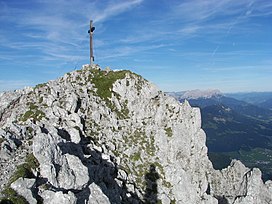
203:
308:
143:
320:
163:
150:
127:
262:
241:
216:
183:
25:
289:
Maukspitze (right) and
Ackerlspitze (centre), seen from Hartkaiser (southwest)
220:
79:
66:
195:
131:
41:
202:. To the north the Maukspitze drops equally sharply into the
186:. To the south, the Maukspitze falls steeply and abruptly (
174:, making it the ninth tallest peak in the Kaisergebirge.
223:. There are many climbing routes of various grades.
142:
95:
56:
40:
35:
18:
194:), in places with vertical rock faces, into the
8:
15:
230:
219:. Both of these climbs start from the
7:
332:Mountains of Tyrol (federal state)
114:
14:
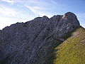
277:View of the summit from the south
282:
270:
255:
233:
113:
106:
24:
1:
309:Tour description with photos
301:Tour description with photos
240:The Maukspitze (left), and
358:
337:Two-thousanders of Austria
162:is a mountain peak in the
172:meters above the Adriatic
100:
23:
30:Summit of the Maukspitze
168:Northern Limestone Alps
248:Waidringer Steinplatte
327:Mountains of the Alps
80:47.55944°N 12.35694°E
200:St. Johann in Tirol
76: /
85:47.55944; 12.35694
36:Highest point
265:on the Maukspitze
204:Kaiserbach valley
156:
155:
349:
342:Kaiser Mountains
313:
305:
286:
274:
259:
237:
146:
117:
116:
110:
91:
90:
88:
87:
86:
81:
77:
74:
73:
72:
69:
51:
28:
16:
357:
356:
352:
351:
350:
348:
347:
346:
317:
316:
311:
303:
297:
290:
287:
278:
275:
266:
260:
251:
245:
238:
229:
212:
180:
144:
138:
137:
136:
135:
134:
125:
124:
123:
122:
118:
84:
82:
78:
75:
70:
67:
65:
63:
62:
52:(7,320 ft)
46:
31:
12:
11:
5:
355:
353:
345:
344:
339:
334:
329:
319:
318:
315:
314:
306:
296:
295:External links
293:
292:
291:
288:
281:
279:
276:
269:
267:
261:
254:
252:
246:seen from the
239:
232:
228:
225:
211:
208:
179:
176:
170:. It is 2,231
154:
153:
148:
140:
139:
126:
120:
119:
112:
111:
105:
104:
103:
102:
101:
98:
97:
93:
92:
60:
54:
53:
44:
38:
37:
33:
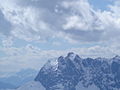
32:
29:
21:
20:
13:
10:
9:
6:
4:
3:
2:
354:
343:
340:
338:
335:
333:
330:
328:
325:
324:
322:
310:
307:
302:
299:
298:
294:
285:
280:
273:
268:
264:
258:
253:
249:
243:
236:
231:
226:
224:
222:
218:
209:
207:
205:
201:
197:
193:
189:
185:
177:
175:
173:
169:
166:range of the
165:
164:Kaisergebirge
161:
152:
151:Kaisergebirge
149:
147:
141:
133:
129:
109:
99:
94:
89:
61:
59:
55:
50:
45:
43:
39:
34:
27:
22:
17:
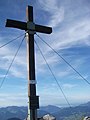
263:Summit cross
242:Ackerlspitze
217:Ackerlspitze
213:
191:
188:Niedersessel
187:
184:Ackerlspitze
181:
159:
157:
145:Parent range
312:(in German)
304:(in German)
83: /
58:Coordinates
49:m (AA)
47:2,231
321:Categories
221:Ackerl Hut
192:Hochsessel
160:Maukspitze
121:Maukspitze
71:12°21′25″E
68:47°33′34″N
19:Maukspitze
250:in winter
244:(centre),
196:Leukental
96:Geography
42:Elevation
198:towards
178:Location
132:Austria
227:Photos
210:Routes
128:Tyrol
158:The
323::
206:.
190:,
130:,
Text is available under the Creative Commons Attribution-ShareAlike License. Additional terms may apply.