460:
436:
508:
424:
472:
448:
484:
400:
496:
388:
364:
376:
412:
228:
45:
220:
293:
29:
321:
307:
52:
246:
The system was renamed the McAlpine Locks and Dam in 1960 in honor of
William McAlpine, who was the only civilian to have ever served as district engineer for the Corps of Louisville. At present, the normal pool elevation is 420 feet (130 m) above sea level and the drainage area above the dam is
459:
435:
507:
423:
471:
447:
399:
483:
769:
349:
387:
363:
598:
247:
91,170 square miles (236,000 km). The average daily flow at McAlpine is 118,000 cubic feet per second (3,340 m/s). The lock chambers are located at the dam on the
Kentucky side of the
774:
203:. They are located at mile point 606.8, and control a 72.9 miles (117.3 km) long navigation pool. The locks and their associated canal were the first major engineering project on the
495:
804:
754:
375:
764:
799:
411:
259:
44:
584:
809:
607:
339:
269:
The McAlpine locks underwent a 10-year, $ 278 million expansion project scheduled to be completed in 2008, but was completed in early 2009.
344:
676:
134:
91:
334:
263:
535:
591:
255:
pool downstream. The hydroelectric plant consists of eight turbine units with a net power generation capacity of 80,000 kilowatts.
529:
794:
759:
524:
208:
636:
278:
240:
165:
541:
779:
701:
666:
555:
814:
651:
819:
784:
641:
789:
631:
227:
731:
691:
656:
626:
326:
722:
706:
681:
646:
621:
547:
711:
696:
243:. The hydroelectric plant at the time was the seventh largest hydroelectric plant in the United States.
219:
671:
298:
200:
79:
661:
251:
and are capable of a normal lift of 37 feet (11 m) between the McAlpine pool upstream and the
236:
252:
172:
281:, a subsidiary of PPL Corporation while the locks are operated by the Army Corps of Engineers.
196:
192:
563:. National Waterways Study, Institute for Water Resources, U.S. Army Corps of Engineers
28:
748:
576:
312:
239:
was added, and the locks were expanded, first by a private company and then by the
320:
211:, designed to allow shipping traffic to navigate through the Falls of the Ohio.
188:
610:
288:
248:
204:
150:
405:
Aerial view of Falls of the Ohio and Locks and Dam No 41 circa 1930s or 1940s
106:
93:
306:
573:
Provides historical context for McAlpine Locks and Dam; good bibliography.
465:
Coast Guard buoy tender Obion entering main lock at McAlpine Locks, 1999
441:
Towboat Steel Trader departing auxiliary lock at McAlpine Locks, 1987
513:
Fourteenth Street Bridge pier and upper gates of McAlpine Dam, 1998
350:
List of attractions and events in the
Louisville metropolitan area
226:
218:
429:
Towboat
Brimstone entering auxiliary lock at McAlpine Locks, 1987
770:
Transportation buildings and structures in
Louisville, Kentucky
580:
477:
Towboat Enid Dibert departing main lock at McAlpine Locks, 1999
453:
Dewatered main lock undergoing repairs at McAlpine Locks, 1987
489:
LG&E Ohio Falls
Generating Station at McAlpine Dam, 1998
550:
from U.S. Army Corps of
Engineers. Retrieved 29 April 2017
544:
from U.S. Army Corps of
Engineers. Retrieved 29 April 2017
538:
from U.S. Army Corps of
Engineers. Retrieved 29 April 2017
393:
McAlpine Locks and Dam navigation chart (detail) from 2010
557:
History of
Navigation in the Ohio River Basin (NWS-83-5)
369:
Chart of Falls of the Ohio and Portland Canal from 1916
548:
History of navigation development on the Ohio River
171:
161:
156:
146:
141:
130:
122:
85:
75:
67:
21:
277:The hydroelectric plant is owned and operated by
775:Buildings and structures in Louisville, Kentucky
381:Locks and Dam No 41 navigation chart from 1934
59:Location of McAlpine Locks and Dam in Kentucky
51:
592:
8:
33:McAlpine Locks and Dam, Louisville, Kentucky
258:In October 2003, McAlpine was designated a
805:United States Army Corps of Engineers dams
755:Transport infrastructure completed in 1830
599:
585:
577:
235:From 1925 to 1927, the dam for generating
27:
18:
417:Aerial view of McAlpine Locks circa 2000
340:List of locks and dams of the Ohio River
765:Energy infrastructure completed in 1927
359:
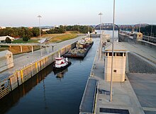
223:Tugboat at McAlpine Locks and Dam, 2012
800:Hydroelectric power plants in Kentucky
345:Transportation in Louisville, Kentucky
135:United States Army Corps of Engineers
7:
335:List of crossings of the Ohio River
264:American Society of Civil Engineers
260:Historic Civil Engineering Landmark
501:Tainter gate at McAlpine Dam, 1998
14:
542:McAlpine Locks and Dam fact sheet
532:2007 version from Wayback Machine
506:
494:
482:
470:
458:
446:
434:
422:
410:
398:
386:
374:
362:
319:
305:
291:
50:
43:
810:1830 establishments in Kentucky
1:
554:Robinson, Michael C. (1983).
279:Louisville Gas & Electric
209:Louisville and Portland Canal
166:Louisville Gas & Electric
241:U.S. Army Corps of Engineers
207:, completed in 1830 as the
16:Dam in Louisville, Kentucky
836:
617:
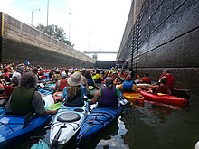
231:Paddling through McAlpine
38:
26:
732:Cannelton Locks and Dam
327:Renewable energy portal
173:Installed capacity
795:Dams on the Ohio River
760:Dams completed in 1927
723:Markland Locks and Dam
536:McAlpine Locks and Dam
530:McAlpine Locks and Dam
232:
224:
185:McAlpine Locks and Dam
71:McAlpine Locks and Dam
22:McAlpine Locks and Dam
608:Locks and dams of the
230:
222:
299:United States portal
201:Louisville, Kentucky
80:Louisville, Kentucky
237:hydroelectric power
137:Louisville District
107:38.2781°N 85.7922°W
103: /
780:Canals in Kentucky
233:
225:
815:Locks of Kentucky
742:
741:
737:
736:
197:Falls of the Ohio
193:hydroelectric dam
181:
180:
142:Dam and spillways
123:Opening date
112:38.2781; -85.7922
827:
820:Locks of Indiana
785:Dams in Kentucky
717:
716:
601:
594:
587:
578:
572:
570:
568:
562:
510:
498:
486:
474:
462:
450:
438:
426:
414:
402:
390:
378:
366:
329:
324:
323:
315:
310:
309:
301:
296:
295:
294:
118:
117:
115:
114:
113:
108:
104:
101:
100:
99:
96:
54:
53:
47:
31:
19:
835:
834:
830:
829:
828:
826:
825:
824:
790:Dams in Indiana
745:
744:
743:
738:
730:
721:
613:
605:
566:
564:
560:
553:
525:LG&E Plants
521:
514:
511:
502:
499:
490:
487:
478:
475:
466:
463:
454:
451:
442:
439:
430:
427:
418:
415:
406:
403:
394:
391:
382:
379:
370:
367:
358:
325:
318:
311:
304:
297:
292:
290:
287:
275:
217:
111:
109:
105:
102:
97:
94:
92:
90:
89:
63:
62:
61:
60:
57:
56:
55:
34:
17:
12:
11:
5:
833:
831:
823:
822:
817:
812:
807:
802:
797:
792:
787:
782:
777:
772:
767:
762:
757:
747:
746:
740:
739:
735:
734:
727:
725:
715:
714:
709:
704:
699:
694:
689:
684:
679:
674:
669:
664:
659:
654:
649:
644:
639:
637:New Cumberland
634:
629:
624:
618:
615:
614:
606:
604:
603:
596:
589:
581:
575:
574:
551:
545:
539:
533:
527:
520:
519:External links
517:
516:
515:
512:
505:
503:
500:
493:
491:
488:
481:
479:
476:
469:
467:
464:
457:
455:
452:
445:
443:
440:
433:
431:
428:
421:
419:
416:
409:
407:
404:
397:
395:
392:
385:
383:
380:
373:
371:
368:
361:
357:
354:
353:
352:
347:
342:
337:
331:
330:
316:
302:
286:
283:
274:
271:
216:
213:
179:
178:
175:
169:
168:
163:
159:
158:
154:
153:
148:
144:
143:
139:
138:
132:
128:
127:
124:
120:
119:
87:
83:
82:
77:
73:
72:
69:
65:
64:
58:
49:
48:
42:
41:
40:
39:
36:
35:
32:
24:
23:
15:
13:
10:
9:
6:
4:
3:
2:
832:
821:
818:
816:
813:
811:
808:
806:
803:
801:
798:
796:
793:
791:
788:
786:
783:
781:
778:
776:
773:
771:
768:
766:
763:
761:
758:
756:
753:
752:
750:
733:
728:
726:
724:
719:
718:
713:
710:
708:
705:
703:
700:
698:
695:
693:
690:
688:
685:
683:
680:
678:
675:
673:
670:
668:
665:
663:
660:
658:
655:
653:
652:Willow Island
650:
648:
645:
643:
640:
638:
635:
633:
630:
628:
625:
623:
620:
619:
616:
612:
609:
602:
597:
595:
590:
588:
583:
582:
579:
559:
558:
552:
549:
546:
543:
540:
537:
534:
531:
528:
526:
523:
522:
518:
509:
504:
497:
492:
485:
480:
473:
468:
461:
456:
449:
444:
437:
432:
425:
420:
413:
408:
401:
396:
389:
384:
377:
372:
365:
360:
355:
351:
348:
346:
343:
341:
338:
336:
333:
332:
328:
322:
317:
314:
308:
303:
300:
289:
284:
282:
280:
272:
270:
267:
265:
261:
256:
254:
250:
244:
242:
238:
229:
221:
214:
212:
210:
206:
202:
198:
194:
190:
187:are a set of
186:
176:
174:
170:
167:
164:
160:
157:Power Station
155:
152:
149:
145:
140:
136:
133:
129:
125:
121:
116:
88:
84:
81:
78:
74:
70:
68:Official name
66:
46:
37:
30:
25:
20:
686:
565:. Retrieved
556:
313:Water portal
276:
268:
257:
245:
234:
184:
182:
729:Downstream:
642:Pike Island
162:Operator(s)
131:Operator(s)
110: /
86:Coordinates
749:Categories
657:Belleville
632:Montgomery
611:Ohio River
249:Ohio River
205:Ohio River
151:Ohio River
98:85°47′32″W
95:38°16′41″N
720:Upstream:
707:Smithland
692:Cannelton
627:Dashields
273:Ownership
253:Cannelton
199:River at
697:Newburgh
687:McAlpine
682:Markland
647:Hannibal
622:Emsworth
567:30 April
285:See also
147:Impounds
76:Location
712:Olmsted
677:Meldahl
672:Greenup
356:Gallery
262:by the
215:History
195:at the
662:Racine
191:and a
702:Myers
561:(PDF)
189:locks
177:80 MW
667:Byrd
569:2017
183:The
126:1830
751::
266:.
600:e
593:t
586:v
571:.
Text is available under the Creative Commons Attribution-ShareAlike License. Additional terms may apply.