344:. It was during this burst of activity that the discovery well for the Mesa field was put in, May 1929, by Olympic Refining Company in the Palisades residential tract, near the intersection of Mohawk Drive and Hudson Road. By the end of the summer, there were 31 oil wells in this small area, just recently subdivided into residential lots. These wells went dry quickly, and the area was abandoned by the next summer, having only produced 20,909 barrels (3,324.3 m) of oil in all. However, residential construction stopped completely; wooden derricks sprung up on many of the small adjacent lots. The sight of these derricks, plainly visible from Santa Barbara harbor, occasioned the first anti-oil protest within the city of Santa Barbara, but since an ordinance had been enacted specifically allowing oil production on the Mesa, which had only recently been considered for residential development, the protests failed to stop drilling and development.
348:
productive area, Fair Acres, came online in March 1934 south of Cliff Drive, extending south across the Mesa all the way to the bluffs overlooking the beach. Sixty-five wells were drilled in the Fair Acres area by 1940. The most prolific producer was well "Cole No. 1" which flowed at an uncontrolled 1,500 barrels per day (240 m/d) into an open sump for two weeks, before being placed on production at around one-tenth of that rate. As the Fair Acres and Vista del Oceano areas are adjacent and not geologically distinct, the
California Department of Conservation lumps them together into a single area dubbed the "Main Area".
177:, in the United States. Discovered in 1929, it was quickly developed and quickly declined, as it proved to be but a relatively small accumulation of oil in a single geologic formation. While the field was active in the 1930s, residential development in most of the Mesa neighborhood of Santa Barbara came to a halt. The field included two major productive areas with a total surface extent of only 210 acres (0.85 km), and produced 3,700,000 barrels (590,000 m) of oil during its brief lifetime.
322:
environmental values. In the 1890s and 1900s The
Summerland Oil Field sprouted hundreds of oil derricks on the beach and along piers into the surf, just five miles (8.0 km) east of the Santa Barbara city boundary; its westward expansion occasioned a midnight raid by a party of vigilantes, led by Reginald Fernald, son of newspaper publisher Charles Fernald, who tore down one of the derricks that had just been built on Miramar Beach.
186:
26:
356:
is doubtful if the field has returned in dividends the money invested. Like most town-lot fields, there are 10 wells where one would have sufficed." Residential construction resumed after the Second World War, as wells were abandoned and sumps filled. The last well was capped in 1972 and the field formally abandoned in 1976.
355:
Even the best-producing wells began to peter out by the late 1930s, and by 1940 only 22 wells out of 107 drilled were still producing, at an average rate of about 10 barrels per day (1.6 m/d). The field had not been particularly profitable. According to S.G. Dolman, writing in 1940, "... It
563:
Schmitt, R. J., Dugan, J. E., and M. R. Adamson. "Industrial
Activity and Its Socioeconomic Impacts: Oil and Three Coastal California Counties." MMS OCS Study 2002-049. Coastal Research Center, Marine Science Institute, University of California, Santa Barbara, California. MMS Cooperative Agreement
312:
The Mesa field was discovered during a time in
California history when oil exploration and drilling was virtually unregulated. When oil was found it was typically developed to the maximum extent possible given the constraints of technology. Cities such as Los Angeles are built over numerous large
298:
Wells rarely produced for long, and a common experience of operators was fast production when the well first hit the oil-bearing sandstone, followed by swift decline, with late production mostly water. The overall structure of the field was imperfectly understood, with some wells producing poorly
351:
The Mesa field was entirely developed by small operators. As the land was subdivided into parcels before oil was discovered, it was a "town-lot" field, and parcel owners were able to drill on their own land without regard for the optimum spacing of wells on a field-wide basis (well spacing is now
201:
from which the neighborhood takes its name is about two miles (3.2 km) long from west to east and about 3,000 feet (910 m) across from north to south. The northern boundary is
Lavigia Hill, which rises north of Cliff Drive; some of the oil wells were drilled on the southern slopes. The
321:
grew with the petroleum industry being the primary economic driver. Santa
Barbara alone of the cities in the region opposed the development of oil fields within its boundaries, with most of the population seeing the industry as incompatible with the town's character with regard to aesthetic and
347:
Three months after the abandonment of the
Palisades area, in September 1930, drillers discovered the much more productive Vista del Oceano area, about two-thirds of a mile east of Palisades along Cliff Drive and on the hillside overlooking the Mesa and the ocean (hence the name). An even more
303:
not visible in well cores, and others to impermeable sand lenses in the
Vaqueros. Total recoverable oil was limited since oil appeared only in one relatively thin rock formation, and even the more productive wells became uneconomic to operate within a few years of their drilling.
284:; no oil has been found in or beneath this unit, even though one well had been drilled into it to a total depth of over 10,000 feet (3,000 m). The Sespe and Vaqueros Formations together form the second-most-prolific oil-producing unit in Southern California.
202:
southern boundary of the mesa is the abrupt drop-off at the cliff overlooking the ocean. The cliffs rise 120 feet (37 m) above the beach at the western end of the mesa, gradually diminishing in height to only 40 feet (12 m) at the eastern end, near
689:. Vol. I (1998), Vol. II (1992), Vol. III (1982). California Department of Conservation, Division of Oil, Gas, and Geothermal Resources (DOGGR). 1,472 pp. Mesa Oil Field information pp. 278–281. PDF file available on CD from www.consrv.ca.gov.
206:. Prior to the oil field being developed, the flat top of the mesa was farmland, with one imposing former residence, the abandoned and earthquake-damaged "Dibblee Castle" built at the eastern end, overlooking Santa Barbara harbor.
256:, at a depth of between 2,000 and 2,500 feet (760 m). The two oil accumulations were about two-thirds of a mile apart horizontally, and around the same depth. Trapping the oil was the overlying impermeable
336:
in 1929 in a similar geographic setting – a blufftop mesa twelve miles (19 km) west of Santa
Barbara – commenced a frenzy of wildcat well drilling along the entire coastline from
758:
773:
763:
189:
The Mesa neighborhood of Santa
Barbara, showing the approximate center of the field's main area of production. In the 1930s there were no houses here, but dozens of oil derricks.
748:
788:
709:
383:
413:
197:
to the west of the Santa Barbara Harbor, within the limits of the City of Santa Barbara, now the location of the neighborhood known as "The Mesa". The
372:
329:, and while not commercially viable and quickly abandoned, suggested to prospectors that it was worth looking more carefully for oil in the vicinity.
295:
of 20 to 24. Sulfur content was 0.45 percent. As its quality was relatively low, it was mainly used for fuel oil, road oil and asphalt.
224:, location of the world's first offshore oil wells into the ocean, is about seven miles (11 km) to the east of the field; the large
783:
352:
more tightly regulated in California). In 1934 there were 34 separate operators on 35 leases; the largest operator had only six wells.
753:
217:. Freezes are extremely rare. Mean annual temperature is approximately 60 °F (16 °C), and the growing season is year-round.
607:
457:
57:
228:
is about ten miles (16 km) to the west. Approximately seven miles to the southeast in the Santa Barbara Channel is the
699:, U.S. Geological Survey Digital Data Series DDS-30, Release 2, one CD-ROM, 19 p. + supporting maps, figures, and tables.
768:
233:
213:, with mild, sometimes rainy winters and dry summers, with the temperature moderated by ocean breezes and a morning
203:
778:
174:
269:
337:
325:
The first well drilled in the Mesa area was by Puritan Oil Co. in 1922, at 601 Flora Vista Drive. It was a
318:
229:
210:
221:
700:
272:
lies between the Monterey and ground surface. Underneath the Vaqueros formation and separated by an
341:
314:
261:
253:
30:
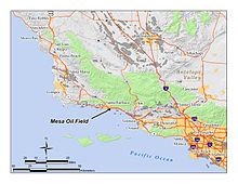
The Mesa Oil Field in Santa Barbara County, California. Other oil fields are shown in light gray.
692:
California Department of Conservation, Oil and Gas Statistics, Annual Report, December 31, 2008.
483:"Geology, Petroleum Development, and Seismicity of the Santa Barbara Channel Region, California"
507:
603:
333:
225:
287:
Oil from the Mesa field was medium to heavy. Early reports give a value of 17 to 18 degrees
257:
281:
461:
300:
288:
742:
39:
273:
214:
292:
291:; the California Department of Natural Resources reports the same oil as having
265:
185:
61:
724:
711:
244:
The structure of the Mesa field is relatively simple. Oil was trapped in two
382:. California Department of Conservation ("DOGGR 2009"). 2009. Archived from
326:
277:
245:
170:
482:
299:
near to better producers; some geologists attributed such discrepancies to
410:
Mesa Oil Field: California Division of Oil and Gas, Summary of Operations
249:
156:
25:
184:
198:
194:
643:
Black tide: the Santa Barbara oil spill and its consequences
508:
James M. Galloway. "Santa Barbara-Ventura Basin Province."
587:. Santa Barbara, California: Tecolote Books. p. 80.
220:
Numerous other oil fields exist within the region. The
645:. New York, New York: Delacorte Press. pp. 89–90.
687:
California Oil and Gas Fields, Volumes I, II and III
602:. Santa Barbara: McNally & Loftin. p. 266.
373:"2008 Report of the state oil & gas supervisor"
151:
133:
128:
120:
112:
104:
96:
88:
83:
75:
67:
53:
45:
35:
18:
447:Sandollar Press, Santa Barbara, CA, 1976. 298-299.
260:, also of Miocene age, and above that unit is the
380:Department of Oil, Gas, and Geothermal Resources
759:Oil fields in Santa Barbara County, California
774:Landforms of Santa Barbara County, California
764:Geography of Santa Barbara County, California
564:Number 14-35-01-00-CA-31603. 244 pages; p. 9.
532:
530:
8:
749:History of Santa Barbara County, California
520:
518:
516:
412:. 1938. Vol. 24 No. 2. p. 5-14. Available
24:
15:
79:Town-lot field; numerous small operators
364:
460:. U.S. Forest Service. Archived from
193:The field occupied a small area on a
7:
789:History of Santa Barbara, California
313:oil fields, and smaller cities like
308:History, production, and operations
248:structures in a band of the porous
173:entirely within the city limits of
14:
445:It Happened in Old Santa Barbara.
585:Santa Barbara, Past and Present
1:
641:Easton, Robert Olney (1972).
600:Santa Barbara History Makers
598:Tompkins, Walker A. (1983).
583:Tompkins, Walker A. (1975).
254:Vaqueros Sandstone formation
234:1969 Santa Barbara oil spill
332:The discovery of the giant
805:
784:20th century in California
204:Santa Barbara City College
155:Vaqueros Sandstone (Lower
754:Santa Barbara, California
175:Santa Barbara, California
137:3.7 million barrels (~5.0
49:Santa Barbara south coast
23:
458:"Ecoregion description"
270:Santa Barbara Formation
268:sediments known as the
209:Climate in the area is
697:Ventura Basin Province
190:
134:Estimated oil in place
443:Tompkins, Walker A.
230:Dos Cuadras Oil Field
188:
725:34.3997°N 119.7111°W
222:Summerland Oil Field
152:Producing formations
97:Start of development
58:Santa Barbara County
769:Mesas of California
721: /
695:Keller, Margaret.
105:Start of production
730:34.3997; -119.7111
631:Dolman, 8, Plate 1
434:Tompkins (1975) 98
264:. A thin layer of
262:Monterey Formation
191:
181:Geographic setting
334:Ellwood Oil Field
226:Ellwood Oil Field
163:
162:
796:
779:Urban oil fields
736:
735:
733:
732:
731:
726:
722:
719:
718:
717:
714:
674:
671:
665:
662:
656:
653:
647:
646:
638:
632:
629:
623:
620:
614:
613:
595:
589:
588:
580:
574:
571:
565:
561:
555:
552:
546:
543:
537:
534:
525:
522:
511:
505:
499:
496:
490:
489:
487:
479:
473:
472:
470:
469:
454:
448:
441:
435:
432:
426:
423:
417:
406:
400:
398:
396:
394:
388:
377:
369:
232:, source of the
169:is an abandoned
143:
142:
68:Offshore/onshore
28:
16:
804:
803:
799:
798:
797:
795:
794:
793:
739:
738:
729:
727:
723:
720:
715:
712:
710:
708:
707:
705:
682:
677:
672:
668:
663:
659:
654:
650:
640:
639:
635:
630:
626:
621:
617:
610:
597:
596:
592:
582:
581:
577:
572:
568:
562:
558:
553:
549:
544:
540:
535:
528:
523:
514:
506:
502:
497:
493:
485:
481:
480:
476:
467:
465:
456:
455:
451:
442:
438:
433:
429:
424:
420:
407:
403:
392:
390:
386:
375:
371:
370:
366:
362:
310:
282:Sespe Formation
242:
183:
140:
138:
31:
12:
11:
5:
802:
800:
792:
791:
786:
781:
776:
771:
766:
761:
756:
751:
741:
740:
704:
703:
701:Available here
693:
690:
683:
681:
678:
676:
675:
666:
657:
648:
633:
624:
615:
608:
590:
575:
566:
556:
547:
538:
526:
512:
500:
491:
474:
449:
436:
427:
418:
408:Dolman, S.G.
401:
363:
361:
358:
309:
306:
241:
238:
182:
179:
167:Mesa Oil Field
161:
160:
153:
149:
148:
135:
131:
130:
126:
125:
122:
118:
117:
114:
110:
109:
106:
102:
101:
98:
94:
93:
90:
86:
85:
81:
80:
77:
73:
72:
69:
65:
64:
55:
51:
50:
47:
43:
42:
37:
33:
32:
29:
21:
20:
19:Mesa Oil Field
13:
10:
9:
6:
4:
3:
2:
801:
790:
787:
785:
782:
780:
777:
775:
772:
770:
767:
765:
762:
760:
757:
755:
752:
750:
747:
746:
744:
737:
734:
702:
698:
694:
691:
688:
685:
684:
679:
673:Dolman, p. 14
670:
667:
661:
658:
652:
649:
644:
637:
634:
628:
625:
619:
616:
611:
609:0-87461-059-1
605:
601:
594:
591:
586:
579:
576:
570:
567:
560:
557:
554:Dolman, 11-14
551:
548:
542:
539:
533:
531:
527:
521:
519:
517:
513:
509:
504:
501:
495:
492:
484:
478:
475:
464:on 2007-08-13
463:
459:
453:
450:
446:
440:
437:
431:
428:
422:
419:
415:
411:
405:
402:
389:on 2017-05-25
385:
381:
374:
368:
365:
359:
357:
353:
349:
345:
343:
339:
335:
330:
328:
323:
320:
316:
307:
305:
302:
296:
294:
290:
285:
283:
279:
275:
271:
267:
263:
259:
255:
251:
247:
239:
237:
235:
231:
227:
223:
218:
216:
212:
211:Mediterranean
207:
205:
200:
196:
187:
180:
178:
176:
172:
168:
158:
154:
150:
146:
136:
132:
127:
123:
119:
115:
111:
107:
103:
99:
95:
91:
87:
84:Field history
82:
78:
74:
70:
66:
63:
59:
56:
52:
48:
44:
41:
40:United States
38:
34:
27:
22:
17:
706:
696:
686:
669:
660:
651:
642:
636:
627:
618:
599:
593:
584:
578:
569:
559:
550:
541:
503:
498:DOGGR, 278-9
494:
477:
466:. Retrieved
462:the original
452:
444:
439:
430:
421:
409:
404:
391:. Retrieved
384:the original
379:
367:
354:
350:
346:
331:
327:wildcat well
324:
311:
297:
286:
274:unconformity
258:Rincon Shale
243:
219:
215:marine layer
208:
192:
166:
164:
144:
728: /
716:119°42′40″W
338:Carpinteria
319:Santa Maria
293:API gravity
266:Pleistocene
121:Abandonment
743:Categories
713:34°23′59″N
680:References
655:DOGGR, 280
545:Dolman, 14
536:DOGGR, 279
468:2014-02-22
393:August 29,
246:anticlinal
129:Production
62:California
524:Dolman, 8
425:Dolman, 5
278:Oligocene
171:oil field
113:Peak year
89:Discovery
76:Operators
301:faulting
147: t)
54:Location
664:MMS, 79
622:MMS, 53
573:MMS, 39
342:Gaviota
315:Ventura
276:is the
250:Miocene
240:Geology
157:Miocene
71:onshore
36:Country
606:
399:p. 95.
46:Region
486:(PDF)
387:(PDF)
376:(PDF)
360:Notes
289:Baumé
280:-age
252:-age
604:ISBN
510:100.
414:here
395:2010
317:and
199:mesa
195:mesa
165:The
124:1976
116:1935
108:1929
100:1929
92:1929
340:to
745::
529:^
515:^
378:.
236:.
141:10
60:,
612:.
488:.
471:.
416:.
397:.
159:)
145:^
139:×
Text is available under the Creative Commons Attribution-ShareAlike License. Additional terms may apply.