139:
434:
417:
88:
190:
99:
77:
979:
The council has two hospitals. 1 government hospital and 1 faith-based hospital that operates under a Public-Private
Partnership. Council has 8 health centers, 6 of which are government, 2 of which are faith-based, and 50 dispensaries, 29 of which are government, 12 of which are faith-based, and 9 of
762:
The majority of the Meru district is occupied by small and medium-sized businesses. In 2017, the district had 2,200 stores, 296 barbershops, 23 hotels, 95 guesthouses, and 264 bars. To name a few, important industries situated there include Jumbo
Textile Ltd, Tanzania Poultry Farm Ltd, Hughes Motors
611:
seasons. The average annual rainfall is 500 mm to 1200 mm, and it usually rains between mid-October and
December, February, and May. The distribution of these rains is completely improper for agricultural and livestock rearing activities in the District. Meru district's soil is relatively
988:
Meru
District's Maternal death rate of 26/100,000; neonatal mortality rate of 6/1000. In general, females are more afflicted than men over the age of five, whereas males under the age of five are more affected than females. This is also reflected in total admissions, where females outnumber males.
962:
schools in the district, 21 of which were government-owned and 17 of which were private. In 2017, the district had 113 public elementary schools and 48 private primary schools. There were 29 state secondary schools and 28 private secondary schools in the same year. Meru
District Council is home to
787:
Meru
District Council has a total population of 268,144 persons according to the Population and Housing Census of 2012. There are 131,264 men (49%) and 136,880 women (51%) among them. Meru District Council is predicted to have a population of 306,352 in 2017, with 149,968 (49%) males and 156,384
796:
According to the legislation, Meru
District Council has a standard administrative structure that extends to all levels, namely the council, the Ward, the Village, and the Sub Village. The district is divided into three divisions, twenty-six wards, 90 villages, and 337 sub-villages.
779:, Lake Duluti, Kalanga Forest Reserve in Nkoanenkoli, NAIC Forest Reserve in Nshapu, Sakila Hill in Sakila, Shumbumbu Hills Caves in Akheri Ward, Mringaringa in Poli Ward, and Usa River Springs Forest Reserve. Ulon'ga Falls are the District's tallest waterfall.
631:
rainfall, with short rains (Vuli) falling from
November to January and long rains (Masika) falling from March to June, resulting in two agricultural seasons with annual rainfall ranging between 500 and 1200 mm and average temperatures of about
682:. However, the situation is significantly better in urban areas, where 67% of all homes have piped water. All of these water sources are held by the village government, community water groups, or individuals. The paved trunk road T2 from
701:
accounting for the remaining 0.5%.The most common source of lightning is kerosene, which is used by 90% of all private households, followed by electricity (biogas, fuel wood,) at 5%. Trade centers such as Usa River
673:
m/day, approximately 64.5% of the total requirement. The percentage of persons that have access to clean and safe water is 64.5%. The percentage of persons that get water within 400 meters is 41%. Deep and shallow
1138:
971:, The Institute of Community Development, Tengeru, National Artificial Insemination Centre (NAIC) and Nelson Mandela University, and The Institute of Livestock Development, Tengeru.
579:
Meru
District has a total size of 1,268.2 square kilometers, with forest reserves covering around 13% (163.7 km). An area of approximately 813.5 km (64.1%) is used for
2182:
788:(51%) females. The average household size is projected to be 5 people. According to the Population of 2012, Meru District Council has an annual population growth rate of 2.7%.
1001:
in terms of morbidity, with a CFR of 0.23. By June 2017, the prevalence of severe malaria had dropped from 10.91% to 5% and the HIV prevalence had dropped from 1.6% to 1.5%.
690:
passes through the district. There is 146 kilometers of road in Meru
District. Only 67.2 km are passable all year, with 32.8 km only usable during the dry seasons.
697:, and commerce centers such as Usa River, Arusha, and Moshi are linked. The primary source of energy for cooking is wood, which accounts for 90% of the total, with
152:
665:(JRO) which is also shared by Hai District in Kilimanjaro Region. As for water infrastructure, the water need in Meru district as of 2017 is 18,381.12
2175:
620:
origins. They are well-drained dark sandy loams with good moisture retention. However, soil erosion occurs in agro-pastoral areas, particularly in
1864:
1593:
993:
is the primary cause of death in younger children, while Pneumonia is the top cause of death in adults, with a case fatality rate (CFR) of 27.
571:, they are the majority of residents in the district. They settled on the southeastern slopes of the mountain and started to farm the land.
806:
2268:
2168:
662:
324:
2210:
1902:
1283:
138:
980:
which are private. There are three dispensaries operating under temporary structures (shistoni, Kitefu and Kisimiri chini).
1551:
1527:
1503:
1479:
1455:
1431:
1407:
1383:
1359:
1335:
1311:
1259:
1235:
1211:
1187:
1037:
738:
are among the crops farmed. Cattle, goats, and poultry are examples of livestock. The district is also one of Tanzania's
591:, 5.7 km (0.4%) is water bodies, and the remaining area of 44.39 km (3.6%) is settlement and unspecified land.
2247:
2215:
1927:
1897:
510:. It covers an area of 1,266 km (489 sq mi). The district is comparable in size to the land area of
2090:
1857:
1586:
2242:
2232:
1917:
1912:
600:
2227:
2085:
1907:
1850:
1579:
422:
2191:
2111:
1825:
1691:
997:
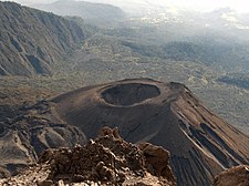
is the main cause of morbidity and mortality among notifiable diseases, with a CFR of 100%, followed by
887:
556:
531:
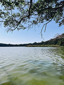
515:
503:
467:
299:
260:
113:
57:
20:
2116:
522:. According to the 2022 Tanzania National Census, the population of Meru District council was 331,603.
433:
1075:
2095:
1803:
968:
772:
588:
2066:
1706:
1612:
1112:"Tanzania: Administrative Division (Regions and Districts) - Population Statistics, Charts and Map"
902:
519:
416:
237:
202:
2009:
645:
564:
495:
491:
2126:
1696:
1010:
892:
1060:
1016:
964:
959:
641:
479:
463:
369:
45:
2131:
694:
687:
507:
439:
514:. Meru District has an max elevation of 3,800 m (12,500 ft) at Rhino Point on
2160:
1963:
679:
613:
499:
334:
1061:"Tanzania: Northern Zone(Districts and Wards) - Population Statistics, Charts and Map"
2262:
2195:
2121:
1994:
1978:
1943:
1873:
1737:
1727:
1701:
1602:
1097:
897:
511:
483:
471:
207:
61:
2136:
1973:
1968:
1958:
1953:
1732:
1671:
1651:
1111:
867:
843:
776:
747:
746:, Kiliflora Ltd in Usa River, Tengeru Flowers in Maji ya Chai, Tanzania Flowers in
743:
739:
617:
604:
568:
487:
121:
87:
2149:
2035:
1761:
1742:
1686:
1641:
882:
833:
710:, is the primary source of energy for cooking in 90% of households, followed by
621:
580:
342:
117:
2014:
735:
608:
560:
551:
The first communities in what would be the Meru District were the now extinct
535:
353:
227:
167:
154:
1681:
877:
703:
698:
648:, some of which serve as irrigation, residential, and cattle water sources.
360:
98:
76:
2199:
2004:
1676:
1661:
1646:
1631:
990:
872:
853:
838:
823:
711:
707:
475:
222:
195:
19:"Meru District" redirects here. For the historical Kenyan districts, see
2061:
1999:
1666:
998:
862:
628:
584:
552:
314:
722:
Agriculture is the most important economic activity in Meru District.
2220:
2056:
2051:
2019:
1948:
1883:
1722:
1656:
1626:
994:
848:
818:
751:
727:
723:
683:
365:
583:
activities, 37.05 km (3%) for grazing, 15 km (0.001%) for
1166:
2144:
1636:
828:
731:
338:
559:
for centuries. The second community to settle in the area is the
1842:
1571:
1557:. Office of the District Executive Director, Meru District. 2017
1533:. Office of the District Executive Director, Meru District. 2017
1509:. Office of the District Executive Director, Meru District. 2017
1485:. Office of the District Executive Director, Meru District. 2017
1461:. Office of the District Executive Director, Meru District. 2017
1437:. Office of the District Executive Director, Meru District. 2017
1413:. Office of the District Executive Director, Meru District. 2017
1389:. Office of the District Executive Director, Meru District. 2017
1365:. Office of the District Executive Director, Meru District. 2017
1341:. Office of the District Executive Director, Meru District. 2017
1317:. Office of the District Executive Director, Meru District. 2017
1265:. Office of the District Executive Director, Meru District. 2017
1241:. Office of the District Executive Director, Meru District. 2017
1217:. Office of the District Executive Director, Meru District. 2017
1193:. Office of the District Executive Director, Meru District. 2017
675:
555:
people, a hunter gatherer group that lived around the slopes of
2164:
1846:
1575:
805:
As of 2012, Meru District was administratively divided into 17
37:
812:
432:
415:
750:, Kilimanjaro Dekker Bruins and Mount Meru Flowers both in
1073:
1,393 km (538 sq mi) for Faroes Islands at
967:: Makumira University College, Patadi Teacher's College,
771:
Meru District is home to tourist attractions such as the
391:
754:
Ward are flower companies situated in Meru District.
693:
Electricity, the district is linked to the national
2104:
2075:
2044:
2028:
1987:
1936:
1890:
1815:
1790:
1770:
1751:
1715:
1619:
428:
411:
386:
376:
359:
349:
330:
323:
313:
305:
295:
287:
282:
274:
266:
256:
248:
243:
233:
221:
213:
201:
183:
31:
1019:,The first Chief of the Tanzanian Defence Force.
518:. The administrative capital of the district is
1552:"Meru District Council Socio Economic Profile"
1528:"Meru District Council Socio Economic Profile"
1504:"Meru District Council Socio Economic Profile"
1480:"Meru District Council Socio Economic Profile"
1456:"Meru District Council Socio Economic Profile"
1432:"Meru District Council Socio Economic Profile"
1408:"Meru District Council Socio Economic Profile"
1384:"Meru District Council Socio Economic Profile"
1360:"Meru District Council Socio Economic Profile"
1336:"Meru District Council Socio Economic Profile"
1312:"Meru District Council Socio Economic Profile"
1260:"Meru District Council Socio Economic Profile"
1236:"Meru District Council Socio Economic Profile"
1212:"Meru District Council Socio Economic Profile"
1188:"Meru District Council Socio Economic Profile"
1167:"Meru and Machame Migrations to Arusha Region"
2176:
1858:
1587:
1133:
1131:
26:District of Arusha in Arusha Region, Tanzania
8:
640:°C (March–August). The district features 11
2183:
2169:
2161:
1865:
1851:
1843:
1594:
1580:
1572:
478:.The District is bordered to the north by
28:
1029:
406:
385:
375:
358:
322:
312:
281:
265:
242:
232:
212:
182:
147:
135:
127:
67:
599:The major climate in Meru District is
563:People, who immigrated there from the
678:are the district's primary source of
427:
410:
348:
329:
304:
294:
286:
273:
255:
247:
220:
200:
7:
1139:"2012 Population and Housing Census"
1146:Development Partners Group Tanzania
587:/fodder, 203.7 km (16%) is in
252:1,266 km (489 sq mi)
16:District of Arusha Region, Tanzania
1791:National Parks and Forest Reserves
1005:Notable persons from Meru District
669:m/day. The water supply was 11,580
14:
663:Kilimanjaro International Airport
188:
137:
97:
86:
75:
1903:Arusha District Council, Arusha
624:Ward of eastern Meru District.
916:The 9 added wards as of 2017:
1:
1284:"Arusha Region Roads Network"
742:capitals. Hortanzania Ltd in
278:3,800 m (12,500 ft)
965:higher learning institutions
958:In 2007, there were only 38
636:°C (January–February) and 22
530:The district is named after
270:1,387 m (4,551 ft)
2076:National Parks and Reserves
1898:Arusha City Council, Arusha
792:Administrative subdivisions
534:, which is named after the
403:Symbols of Tanzania
2285:
2269:Districts of Arusha Region
2091:Lake Manyara National Park
1800:Mount Meru National Forest
1038:"Longido District Profile"
984:Epidimiology and mortality
18:
2206:
1880:
1797:Ngurudoto National Forest
1609:
661:Meru district is home to
445:
407:
402:
398:
148:
136:
128:
68:
55:
1013:, novelist and diplomat
969:The University of Arusha
2211:Arusha District Council
2086:Tarangire National Park
1988:National Historic Sites
1098:"Rhino Point Elevation"
309:260/km (680/sq mi)
168:3.371500°S 36.8966000°E
143:Meru District in Arusha
2045:Major Cities and Towns
1771:Major Cities and Towns
1076:"Area size comparison"
437:
420:
275:Highest elevation
38:
1116:www.citypopulation.de
1078:. Nation master. 2022
508:Arusha Urban District
504:Arusha Rural District
502:, and to the west by
456:Meru District Council
436:
419:
173:-3.371500; 36.8966000
21:Meru (disambiguation)
2096:Arusha National Park
1804:Arusha National Park
949:Health and Education
773:Arusha National Park
763:Ltd, and Maji Tech.
589:Arusha National Park
331: • Settler
306: • Density
2216:Arusha City Council
1928:Ngorongoro District
423:Jackson's widowbird
350: • Native
164: /
110:From top to bottom:
2105:National Landmarks
2010:Nasera Rockshelter
1833:Mount Meru Ashcone
1808:Lake Duluti Forest
758:Industry and Trade
565:Usambara Mountains
496:Simanjiro District
494:, to the south by
492:Kilimanjaro Region
466:) is one of seven
438:
421:
377:Tanzanian Postcode
288: • Total
249: • Total
131:The lakes district
114:Mount Meru Ashcone
2256:
2255:
2158:
2157:
2127:Ngorongoro Crater
2117:Monduli Mountains
2082:Mount Meru Forest
1840:
1839:
1011:Peter K. Palangyo
913:
912:
627:The district has
547:First communities
482:, to the east by
454:, officially the
449:
448:
296: • Rank
257: • Rank
2276:
2185:
2178:
2171:
2162:
2132:Ngurudoto Crater
2029:Rivers and Lakes
1918:Monduli District
1913:Longido District
1867:
1860:
1853:
1844:
1830:Ngurudoto Crater
1752:Rivers and Lakes
1596:
1589:
1582:
1573:
1566:
1565:
1563:
1562:
1556:
1548:
1542:
1541:
1539:
1538:
1532:
1524:
1518:
1517:
1515:
1514:
1508:
1500:
1494:
1493:
1491:
1490:
1484:
1476:
1470:
1469:
1467:
1466:
1460:
1452:
1446:
1445:
1443:
1442:
1436:
1428:
1422:
1421:
1419:
1418:
1412:
1404:
1398:
1397:
1395:
1394:
1388:
1380:
1374:
1373:
1371:
1370:
1364:
1356:
1350:
1349:
1347:
1346:
1340:
1332:
1326:
1325:
1323:
1322:
1316:
1308:
1302:
1301:
1299:
1297:
1288:
1280:
1274:
1273:
1271:
1270:
1264:
1256:
1250:
1249:
1247:
1246:
1240:
1232:
1226:
1225:
1223:
1222:
1216:
1208:
1202:
1201:
1199:
1198:
1192:
1184:
1178:
1177:
1175:
1173:
1163:
1157:
1156:
1154:
1152:
1143:
1135:
1126:
1125:
1123:
1122:
1108:
1102:
1101:
1094:
1088:
1087:
1085:
1083:
1071:
1065:
1064:
1057:
1051:
1050:
1048:
1047:
1042:
1034:
1017:Mrisho Sarakikya
813:
672:
668:
639:
635:
603:, with distinct
601:tropical savanna
480:Longido District
394:
392:Official website
194:
192:
191:
179:
178:
176:
175:
174:
169:
165:
162:
161:
160:
157:
141:
101:
90:
79:
50:
49:
41:
29:
2284:
2283:
2279:
2278:
2277:
2275:
2274:
2273:
2259:
2258:
2257:
2252:
2202:
2189:
2159:
2154:
2141:Ol Donyo Lengai
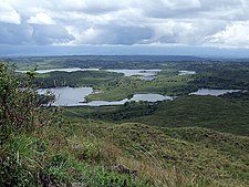
2100:
2071:
2040:
2024:
1983:
1932:
1908:Karatu District
1886:
1876:
1871:
1841:
1836:
1811:
1786:
1766:
1747:
1711:
1615:
1605:
1600:
1570:
1569:
1560:
1558:
1554:
1550:
1549:
1545:
1536:
1534:
1530:
1526:
1525:
1521:
1512:
1510:
1506:
1502:
1501:
1497:
1488:
1486:
1482:
1478:
1477:
1473:
1464:
1462:
1458:
1454:
1453:
1449:
1440:
1438:
1434:
1430:
1429:
1425:
1416:
1414:
1410:
1406:
1405:
1401:
1392:
1390:
1386:
1382:
1381:
1377:
1368:
1366:
1362:
1358:
1357:
1353:
1344:
1342:
1338:
1334:
1333:
1329:
1320:
1318:
1314:
1310:
1309:
1305:
1295:
1293:
1286:
1282:
1281:
1277:
1268:
1266:
1262:
1258:
1257:
1253:
1244:
1242:
1238:
1234:
1233:
1229:
1220:
1218:
1214:
1210:
1209:
1205:
1196:
1194:
1190:
1186:
1185:
1181:
1171:
1169:
1165:
1164:
1160:
1150:
1148:
1141:
1137:
1136:
1129:
1120:
1118:
1110:
1109:
1105:
1096:
1095:
1091:
1081:
1079:
1074:
1072:
1068:
1059:
1058:
1054:
1045:
1043:
1040:
1036:
1035:
1031:
1026:
1007:
986:
977:
956:
951:
938:Shambarai Burka
914:
803:
794:
785:
769:
760:
720:
670:
666:
659:
654:
644:rivers and 143
637:
633:
597:
577:
549:
544:
528:
440:Guereza colobus
390:
382:
189:
187:
172:
170:
166:
163:
158:
155:
153:
151:
150:
144:
132:
129:Nickname:
124:
112:
107:
106:
105:
104:
103:
102:
93:
92:
91:
82:
81:
80:
64:
51:
43:
36:
34:
27:
24:
17:
12:
11:
5:
2282:
2280:
2272:
2271:
2261:
2260:
2254:
2253:
2251:
2250:
2245:
2240:
2235:
2230:
2225:
2224:
2223:
2213:
2207:
2204:
2203:
2190:
2188:
2187:
2180:
2173:
2165:
2156:
2155:
2153:
2152:
2147:
2142:
2139:
2134:
2129:
2124:
2119:
2114:
2108:
2106:
2102:
2101:
2099:
2098:
2093:
2088:
2083:
2079:
2077:
2073:
2072:
2070:
2069:
2064:
2059:
2054:
2048:
2046:
2042:
2041:
2039:
2038:
2032:
2030:
2026:
2025:
2023:
2022:
2017:
2012:
2007:
2002:
1997:
1991:
1989:
1985:
1984:
1982:
1981:
1976:
1971:
1966:
1961:
1956:
1951:
1946:
1940:
1938:
1937:Native Peoples
1934:
1933:
1931:
1930:
1925:
1920:
1915:
1910:
1905:
1900:
1894:
1892:
1888:
1887:
1881:
1878:
1877:
1872:
1870:
1869:
1862:
1855:
1847:
1838:
1837:
1835:
1834:
1831:
1828:
1823:
1819:
1817:
1816:Meru Landmarks
1813:
1812:
1810:
1809:
1806:
1801:
1798:
1794:
1792:
1788:
1787:
1785:
1784:
1781:
1778:
1774:
1772:
1768:
1767:
1765:
1764:
1759:
1755:
1753:
1749:
1748:
1746:
1745:
1740:
1735:
1730:
1725:
1719:
1717:
1716:Native Peoples
1713:
1712:
1710:
1709:
1704:
1699:
1697:Seela Sing'isi
1694:
1689:
1684:
1679:
1674:
1669:
1664:
1659:
1654:
1649:
1644:
1639:
1634:
1629:
1623:
1621:
1617:
1616:
1613:Usa River Town
1610:
1607:
1606:
1601:
1599:
1598:
1591:
1584:
1576:
1568:
1567:
1543:
1519:
1495:
1471:
1447:
1423:
1399:
1375:
1351:
1327:
1303:
1275:
1251:
1227:
1203:
1179:
1158:
1127:
1103:
1089:
1066:
1052:
1028:
1027:
1025:
1022:
1021:
1020:
1014:
1006:
1003:
985:
982:
976:
973:
955:
952:
950:
947:
946:
945:
942:
939:
936:
933:
930:
927:
924:
921:
911:
910:
906:
905:
900:
895:
893:Seela Sing'isi
890:
885:
880:
875:
870:
865:
858:
857:
856:
851:
846:
841:
836:
831:
826:
821:
811:
802:
799:
793:
790:
784:
781:
768:
765:
759:
756:
719:
716:
680:drinking water
658:
657:Infrastructure
655:
653:
650:
596:
593:
576:
573:
548:
545:
543:
540:
527:
524:
500:Manyara Region
490:Districts of
460:Wilaya ya Meru
447:
446:
443:
442:
430:
426:
425:
413:
409:
408:
405:
404:
400:
399:
396:
395:
388:
384:
383:
380:
378:
374:
373:
363:
357:
356:
351:
347:
346:
332:
328:
327:
321:
320:
317:
311:
310:
307:
303:
302:
297:
293:
292:
289:
285:
284:
280:
279:
276:
272:
271:
268:
264:
263:
258:
254:
253:
250:
246:
245:
241:
240:
235:
231:
230:
225:
219:
218:
215:
211:
210:
205:
199:
198:
185:
181:
180:
146:
145:
142:
134:
133:
130:
126:
125:
108:
96:
95:
94:
85:
84:
83:
74:
73:
72:
71:
70:
69:
66:
65:
56:
53:
52:
39:Wilaya ya Meru
35:
32:
25:
15:
13:
10:
9:
6:
4:
3:
2:
2281:
2270:
2267:
2266:
2264:
2249:
2246:
2244:
2241:
2239:
2236:
2234:
2231:
2229:
2226:
2222:
2219:
2218:
2217:
2214:
2212:
2209:
2208:
2205:
2201:
2197:
2196:Arusha Region
2193:
2186:
2181:
2179:
2174:
2172:
2167:
2166:
2163:
2151:
2148:
2146:
2143:
2140:
2138:
2135:
2133:
2130:
2128:
2125:
2123:
2122:Olduvai Gorge
2120:
2118:
2115:
2113:
2110:
2109:
2107:
2103:
2097:
2094:
2092:
2089:
2087:
2084:
2081:
2080:
2078:
2074:
2068:
2065:
2063:
2060:
2058:
2055:
2053:
2050:
2049:
2047:
2043:
2037:
2034:
2033:
2031:
2027:
2021:
2018:
2016:
2013:
2011:
2008:
2006:
2003:
2001:
1998:
1996:
1995:Olduvai Gorge
1993:
1992:
1990:
1986:
1980:
1977:
1975:
1972:
1970:
1967:
1965:
1962:
1960:
1957:
1955:
1952:
1950:
1947:
1945:
1942:
1941:
1939:
1935:
1929:
1926:
1924:
1923:Meru District
1921:
1919:
1916:
1914:
1911:
1909:
1906:
1904:
1901:
1899:
1896:
1895:
1893:
1889:
1885:
1879:
1875:
1874:Arusha Region
1868:
1863:
1861:
1856:
1854:
1849:
1848:
1845:
1832:
1829:
1827:
1824:
1821:
1820:
1818:
1814:
1807:
1805:
1802:
1799:
1796:
1795:
1793:
1789:
1782:
1779:
1776:
1775:
1773:
1769:
1763:
1760:
1758:Momella Lakes
1757:
1756:
1754:
1750:
1744:
1741:
1739:
1736:
1734:
1731:
1729:
1726:
1724:
1721:
1720:
1718:
1714:
1708:
1705:
1703:
1702:Songoro, Meru
1700:
1698:
1695:
1693:
1690:
1688:
1685:
1683:
1680:
1678:
1675:
1673:
1670:
1668:
1665:
1663:
1660:
1658:
1655:
1653:
1650:
1648:
1645:
1643:
1640:
1638:
1635:
1633:
1630:
1628:
1625:
1624:
1622:
1618:
1614:
1608:
1604:
1603:Meru District
1597:
1592:
1590:
1585:
1583:
1578:
1577:
1574:
1553:
1547:
1544:
1529:
1523:
1520:
1505:
1499:
1496:
1481:
1475:
1472:
1457:
1451:
1448:
1433:
1427:
1424:
1409:
1403:
1400:
1385:
1379:
1376:
1361:
1355:
1352:
1337:
1331:
1328:
1313:
1307:
1304:
1292:
1285:
1279:
1276:
1261:
1255:
1252:
1237:
1231:
1228:
1213:
1207:
1204:
1189:
1183:
1180:
1168:
1162:
1159:
1147:
1140:
1134:
1132:
1128:
1117:
1113:
1107:
1104:
1099:
1093:
1090:
1077:
1070:
1067:
1062:
1056:
1053:
1039:
1033:
1030:
1023:
1018:
1015:
1012:
1009:
1008:
1004:
1002:
1000:
996:
992:
983:
981:
974:
972:
970:
966:
961:
953:
948:
943:
940:
937:
934:
931:
928:
925:
922:
919:
918:
917:
909:
904:
901:
899:
898:Songoro, Meru
896:
894:
891:
889:
886:
884:
881:
879:
876:
874:
871:
869:
866:
864:
861:
860:
859:
855:
852:
850:
847:
845:
842:
840:
837:
835:
832:
830:
827:
825:
822:
820:
817:
816:
815:
814:
810:
808:
800:
798:
791:
789:
782:
780:
778:
777:Momella Lakes
774:
766:
764:
757:
755:
753:
749:
745:
741:
740:horticultural
737:
733:
729:
725:
717:
715:
713:
709:
705:
700:
696:
691:
689:
685:
681:
677:
664:
656:
651:
649:
647:
643:
630:
625:
623:
619:
615:
610:
606:
602:
594:
592:
590:
586:
582:
574:
572:
570:
566:
562:
558:
554:
546:
541:
539:
537:
533:
525:
523:
521:
517:
513:
512:Faroe Islands
509:
505:
501:
497:
493:
489:
485:
481:
477:
473:
472:Arusha Region
469:
465:
461:
457:
453:
452:Meru District
444:
441:
435:
431:
424:
418:
414:
401:
397:
393:
389:
379:
371:
367:
364:
362:
355:
352:
344:
340:
336:
333:
326:
325:Ethnic groups
318:
316:
308:
301:
300:3rd in Arusha
298:
290:
277:
269:
262:
261:5th in Arusha
259:
251:
239:
236:
229:
226:
224:
216:
209:
208:Arusha Region
206:
204:
197:
186:
177:
159:36°53′47.76″E
149:Coordinates:
140:
123:
122:Momella lakes
119:
115:
111:
100:
89:
78:
63:
59:
54:
47:
40:
33:Meru District
30:
22:
2237:
2137:Mungu Crater
1954:Chaga people
1922:
1783:Maji ya Chai
1672:Ngarenanyuki
1652:Maji ya Chai
1559:. Retrieved
1546:
1535:. Retrieved
1522:
1511:. Retrieved
1498:
1487:. Retrieved
1474:
1463:. Retrieved
1450:
1439:. Retrieved
1426:
1415:. Retrieved
1402:
1391:. Retrieved
1378:
1367:. Retrieved
1354:
1343:. Retrieved
1330:
1319:. Retrieved
1306:
1294:. Retrieved
1290:
1278:
1267:. Retrieved
1254:
1243:. Retrieved
1230:
1219:. Retrieved
1206:
1195:. Retrieved
1182:
1170:. Retrieved
1161:
1149:. Retrieved
1145:
1119:. Retrieved
1115:
1106:
1092:
1080:. Retrieved
1069:
1055:
1044:. Retrieved
1032:
987:
978:
957:
915:
907:
868:Ngarenanyuki
844:Maji ya Chai
804:
795:
786:
783:Demographics
770:
761:
748:Maji ya Chai
744:Maji ya Chai
721:
706:, including
692:
660:
626:
598:
581:agricultural
578:
569:Tanga Region
550:
529:
459:
455:
451:
450:
217:1 July 2007
156:03°22′17.4″S
109:
2150:Lake Natron
2036:Lake Duluti
1822:Lake Duluti
1762:Lake Duluti
1687:Nkoarisambu
883:Nkoarisambu
718:Agriculture
616:due to its
171: /
118:Lake Duluti
2248:Ngorongoro
2112:Mount Meru
2015:Mumba Cave
1826:Mount Meru
1561:2023-03-05
1537:2023-03-05
1513:2023-03-05
1489:2023-03-05
1465:2023-03-05
1441:2023-03-05
1417:2023-03-05
1393:2023-03-05
1369:2023-03-05
1345:2023-03-05
1321:2023-03-05
1269:2023-03-05
1245:2023-03-05
1221:2023-03-05
1197:2023-03-05
1172:17 October
1121:2024-02-10
1046:2023-03-05
1024:References
932:Nkoanokeli
736:sunflowers
699:gas stoves
557:Mount Meru
536:Rwa people
532:Mount Meru
516:Mount Meru
283:Population
228:Rwa people
2192:Districts
2067:Usa River
1891:Districts
1882:Capital:
1777:Usa River
1707:Usa River
1682:Nkoaranga
1611:Capital:
1296:20 August
989:Clinical
960:secondary
954:Education
926:Maruvango
903:Usa River
878:Nkoaranga
704:fuel wood
642:perennial
575:Geography
526:Etymology
520:Usa River
468:districts
361:Time zone
267:Elevation
238:Usa River
223:Named for
2263:Category
2200:Tanzania
2005:Engaruka
1944:Waarusha
1780:Kikatiti
1728:Waarusha
1677:Nkoanrua
1662:Maroroni
1647:Leguruki
1642:King'ori
1632:Kikatiti
1291:TanRoads
1151:7 August
935:Ambureni
929:Imbaseni
873:Nkoanrua
854:Maroroni
839:Leguruki
834:King'ori
824:Kikatiti
712:kerosene
708:charcoal
622:King'ori
618:volcanic
476:Tanzania
214:District
196:Tanzania
120:and the
58:District
2243:Monduli
2233:Longido
2062:Namanga
2000:Laetoli
1964:Datooga
1959:Hadzabe
1667:Mbuguni
1082:5 March
999:Malaria
944:Majengo
941:Ngabobo
863:Mbuguni
767:Tourism
728:bananas
714:at 5%.
652:Economy
646:springs
629:bimodal
614:fertile
595:Climate
585:pasture
553:Koningo
542:History
470:of the
464:Swahili
387:Website
335:Swahili
315:Demonym
291:331,603
234:Capital
184:Country
46:Swahili
2228:Karatu
2057:Karatu
2052:Arusha
2020:Peninj
1979:Maasai
1884:Arusha
1738:Maasai
1723:Wameru
1657:Makiba
1627:Akheri
995:Rabies
975:Health
920:Malula
908:
849:Makiba
819:Akheri
775:, the
752:Akheri
734:, and
724:Coffee
684:Arusha
671:
667:
638:
634:
429:Mammal
341:&
319:Meruan
203:Region
193:
62:Arusha
42:
2145:Gelai
1974:Iraqw
1969:Sonjo
1733:Chaga
1637:Kikwe
1620:Wards
1555:(PDF)
1531:(PDF)
1507:(PDF)
1483:(PDF)
1459:(PDF)
1435:(PDF)
1411:(PDF)
1387:(PDF)
1363:(PDF)
1339:(PDF)
1315:(PDF)
1287:(PDF)
1263:(PDF)
1239:(PDF)
1215:(PDF)
1191:(PDF)
1142:(PDF)
1041:(PDF)
963:five
923:Uwiro
829:Kikwe
807:wards
801:Wards
732:maize
688:Moshi
676:wells
605:rainy
462:, in
381:233xx
366:UTC+3
339:Chaga
2238:Meru
2221:City
1949:Meru
1743:Pare
1692:Poli
1298:2019
1174:2021
1153:2019
1084:2023
991:AIDS
888:Poli
695:grid
607:and
561:Meru
506:and
486:and
484:Siha
412:Bird
343:Pare
244:Area
2194:of
686:to
609:dry
567:in
498:of
488:Hai
474:of
370:EAT
354:Rwa
60:of
2265::
2198:,
1289:.
1144:.
1130:^
1114:.
809::
730:,
726:,
632:25
538:.
337:,
116:,
2184:e
2177:t
2170:v
1866:e
1859:t
1852:v
1595:e
1588:t
1581:v
1564:.
1540:.
1516:.
1492:.
1468:.
1444:.
1420:.
1396:.
1372:.
1348:.
1324:.
1300:.
1272:.
1248:.
1224:.
1200:.
1176:.
1155:.
1124:.
1100:.
1086:.
1063:.
1049:.
458:(
372:)
368:(
345:,
48:)
44:(
23:.
Text is available under the Creative Commons Attribution-ShareAlike License. Additional terms may apply.