928:
35:
24:
177:
160:
137:
25:
837:
380:, and appropriations for both were first requested in 1904. In the case of this light construction was delayed by the inability of the first contractor to set the caisson before exhausting the budget, so that the caisson was not set in place until 1909. A wooden shed was mounted and a light first exhibited that September, but the superstructure was not completed until 1913, again due to financial requirements.
387:
imported from France was used. This lens was later replaced by an
American-made model which served until the early 2000s. Around 1940 the superstructure was painted red, a color it has retained ever since. The keepers of this light controlled that of the Elbow of Cross Ledge Light when the latter was
405:
The grandson of
Nehemiah Maull's great-great-granddaughter (Ethel Maxwell), Bryan Helm, served for many years as Port Captain of the Cape May, New Jersey and Delaware Bay Authority, not far from where his direct ancestor, Nehemiah Maull, worked as Delaware River pilot. He is a graduate of the
1169:
1164:
1136:
418:
373:. The name of the shoal commemorates Nehemiah Maull, a river pilot who was drowned in 1780 when the ship in which he intended to sail to England in order to make a claim on an inheritance was wrecked on the then-unnamed shoal.
951:
868:
494:
1090:
1072:
1034:
981:
936:
897:
861:
682:
1140:
961:
1179:
365:
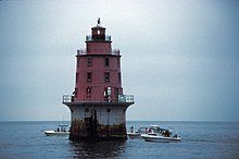
This light, the last offshore lighthouse to be erected in
Delaware Bay, marks one of a series of shoals along the eastern side of the shipping channel, between the
854:
502:
1174:
971:
1047:
927:
61:
705:
1042:
889:
675:
1159:
261:
877:
462:
443:
252:
1052:
1014:
668:
695:
391:
The
Fresnel lens has recently been replaced with a conventional modern 500 mm beacon, with the old lens to be displayed at the
609:
946:
816:
533:
399:
350:
402:
made the Miah Maull Shoal Light (along with 11 others) available at no cost to public organizations willing to preserve them.
34:
994:
966:
956:
881:
342:
846:
736:
54:
902:
525:
826:
756:
366:
1105:
1004:
1122:
912:
821:
776:
761:
1019:
999:
726:
526:"GSA Making 12 Historic Lighthouses Available at No Cost to Public Organizations Willing to Preserve Them"
370:
1117:
811:
647:
448:
409:
As of 7/7/15, it was for sale by the
General Services Administration with a minimum bid of $ 10,000.00.
786:
771:
222:
176:
159:
136:
1009:
989:
731:
721:
559:
1024:
791:
716:
1057:
469:
796:
746:
377:
1080:
907:
836:
801:
766:
751:
392:
917:
643:
1099:
806:
741:
613:
644:"Inventory of Historic Light Stations: New Jersey Lighthouses: Miah Maull Shoal Light"
588:
303:
1153:
1062:
354:
628:
384:
338:
206:
468:. NJ DEP - Historic Preservation Office. April 1, 2010. p. 12. Archived from
1137:
National
Register of Historic Places listings in Cumberland County, New Jersey
691:
495:"For sale: Waterfront property; cozy, great views, plenty of light, needs TLC"
419:
National
Register of Historic Places listings in Cumberland County, New Jersey
346:
560:"GSA Auctions, General Services Administration, Government Site for Auctions"
76:
63:
660:
537:
376:
This light and the Elbow of Cross Ledge Light were intended to replace the
463:"New Jersey and National Registers of Historic Places - Cumberland County"
1170:
Transportation buildings and structures in
Cumberland County, New Jersey
1165:
Lighthouses on the
National Register of Historic Places in New Jersey
168:
438:
610:"Historic Light Station Information and Photography: New Jersey"
594:
850:
664:
908:
Maurice River
Lighthouse and East Point Archeological District
612:. United States Coast Guard Historian's Office. Archived from
49:
Lower Delaware Bay 5 mi. SW of Egg Island Point, Delaware Bay
383:
Originally the light was painted brown, and a fourth-order
337:
is a lighthouse on the north side of the ship channel in
156:
National Register of Historic Places listed place
388:
automated in 1951. In 1973 the light was automated.
1089:
1071:
1033:
980:
935:
888:
319:
309:
296:
288:
280:
272:
221:
213:
201:
193:
188:
167:
152:
144:
129:
121:
113:
105:
97:
92:
53:
45:
209:(original), 500 millimetres (20 in) (current)
1141:List of National Historic Landmarks in New Jersey
962:Old Broad Street Presbyterian Church and Cemetery
406:Merchant Marine Academy and is a Navy reservist.
862:
676:
8:
19:
972:Trinity African Methodist Episcopal Church
869:
855:
847:
683:
669:
661:
217:12 nautical miles (22 km; 14 mi)
175:
158:
135:
33:
18:
952:Bethel African Methodist Episcopal Church
253:U.S. National Register of Historic Places
706:List of lighthouses in the United States
284:Lynchburg Foundry Co.; Tatnall-Brown Co.
1043:Bivalve Oyster Packing Houses and Docks
430:
1180:New Jersey Register of Historic Places
439:"National Register Information System"
262:New Jersey Register of Historic Places
1048:Landis Theatre–Mori Brothers Building
7:
878:National Register of Historic Places
444:National Register of Historic Places
1015:John and Elizabeth Remington House
14:
1175:1913 establishments in New Jersey
926:
835:
353:, southwest of the mouth of the
23:
1053:Millville's First Bank Building
817:Tinicum Island Rear Range Light
534:General Services Administration
400:General Services Administration
351:East Coast of the United States
311:
298:
1:
1160:Lighthouses completed in 1913
995:Deerfield Pike Tollgate House
957:Deerfield Presbyterian Church
913:Mauricetown Historic District
882:Cumberland County, New Jersey
629:"Miah Maull Shoal Lighthouse"
737:Chapel Hill Rear Range Light
597:Office of Coast Survey. 2008
133:14 m (46 ft)
903:Greenwich Historic District
898:Bridgeton Historic District
245:Miah Maull Shoal Lighthouse
148:conical with lantern on top
1196:
827:Waackaack Rear Range Light
757:Elbow of Cross Ledge Light
367:Elbow of Cross Ledge Light
1131:
924:
833:
712:
702:
590:Chart 12304: Delaware Bay
327:
297:NRHP reference
268:
259:
250:
243:
239:
235:
231:
184:
41:
32:
1005:Caesar Hoskins Log Cabin
292:Conical tower lighthouse
289:Architectural style
276:0.7 acres (0.28 ha)
1123:Spindrift Sailing Yacht
762:Finns Point Range Light
631:. lighthousefriends.com
1113:Miah Maull Shoal Light
1020:Samuel W. Seeley House
1000:Gen. James Giles House
782:Miah Maull Shoal Light
727:Brandywine Shoal Light
371:Brandywine Shoal Light
335:Miah Maull Shoal Light
20:Miah Maull Shoal Light
1118:Ship John Shoal Light
947:Beth Hillel Synagogue
812:Ship John Shoal Light
648:National Park Service
449:National Park Service
77:39.12667°N 75.20972°W
1063:Vineland High School
822:Tucker's Beach Light
787:Navesink Twin Lights
777:Ludlam's Beach Light
772:Hereford Inlet Light
1010:Thomas Maskel House
990:Jeremiah Buck House
732:Cape May Lighthouse
722:Barnegat Lighthouse
197:59 feet (18 m)
82:39.12667; -75.20972
73: /
29:
1025:Wood Mansion House
792:Robbins Reef Light
717:Absecon Lighthouse
524:Beatty, MaryAnne.
398:In June 2011, the
1147:
1146:
844:
843:
797:Romer Shoal Light
747:Cross Ledge Light
593:(Map). 1:80,000.
451:. March 13, 2009.
378:Cross Ledge Light
343:Cumberland County
331:
330:
109:cast iron caisson
1187:
1081:Indian Head Site
967:Old Stone Church
930:
871:
864:
857:
848:
839:
802:Sandy Hook Light
767:Great Beds Light
752:East Point Light
685:
678:
671:
662:
657:
655:
654:
639:
637:
636:
624:
622:
621:
605:
603:
602:
575:
574:
572:
570:
556:
550:
549:
547:
545:
536:. Archived from
521:
515:
514:
512:
510:
501:. Archived from
491:
485:
484:
482:
480:
474:
467:
459:
453:
452:
435:
393:East Point Light
323:February 4, 1991
313:
300:
180:
179:
163:
162:
140:
139:
88:
87:
85:
84:
83:
78:
74:
71:
70:
69:
66:
37:
30:
28:
27:
1195:
1194:
1190:
1189:
1188:
1186:
1185:
1184:
1150:
1149:
1148:
1143:
1127:
1085:
1067:
1058:Potter's Tavern
1029:
976:
938:
931:
922:
918:Siloam Cemetery
884:
875:
845:
840:
831:
708:
698:
689:
652:
650:
642:
634:
632:
627:
619:
617:
608:
600:
598:
587:
584:
579:
578:
568:
566:
564:gsaauctions.gov
558:
557:
553:
543:
541:
540:on 22 June 2011
523:
522:
518:
508:
506:
505:on 15 July 2011
493:
492:
488:
478:
476:
475:on July 9, 2003
472:
465:
461:
460:
456:
437:
436:
432:
427:
415:
363:
264:
255:
246:
174:
157:
134:
81:
79:
75:
72:
67:
64:
62:
60:
59:
21:
17:
12:
11:
5:
1193:
1191:
1183:
1182:
1177:
1172:
1167:
1162:
1152:
1151:
1145:
1144:
1132:
1129:
1128:
1126:
1125:
1120:
1115:
1110:
1103:
1100:A. J. Meerwald
1095:
1093:
1087:
1086:
1084:
1083:
1077:
1075:
1069:
1068:
1066:
1065:
1060:
1055:
1050:
1045:
1039:
1037:
1031:
1030:
1028:
1027:
1022:
1017:
1012:
1007:
1002:
997:
992:
986:
984:
978:
977:
975:
974:
969:
964:
959:
954:
949:
943:
941:
933:
932:
925:
923:
921:
920:
915:
910:
905:
900:
894:
892:
886:
885:
876:
874:
873:
866:
859:
851:
842:
841:
834:
832:
830:
829:
824:
819:
814:
809:
807:Sea Girt Light
804:
799:
794:
789:
784:
779:
774:
769:
764:
759:
754:
749:
744:
742:Conover Beacon
739:
734:
729:
724:
719:
713:
710:
709:
703:
700:
699:
690:
688:
687:
680:
673:
665:
659:
658:
640:
625:
606:
583:
580:
577:
576:
551:
516:
486:
454:
429:
428:
426:
423:
422:
421:
414:
411:
362:
359:
329:
328:
325:
324:
321:
317:
316:
314:
307:
306:
301:
294:
293:
290:
286:
285:
282:
278:
277:
274:
270:
269:
266:
265:
260:
257:
256:
251:
248:
247:
244:
241:
240:
237:
236:
233:
232:
229:
228:
225:
223:Characteristic
219:
218:
215:
211:
210:
203:
199:
198:
195:
191:
190:
186:
185:
182:
181:
171:
165:
164:
154:
150:
149:
146:
142:
141:
131:
127:
126:
123:
119:
118:
115:
111:
110:
107:
103:
102:
99:
95:
94:
90:
89:
57:
51:
50:
47:
43:
42:
39:
38:
15:
13:
10:
9:
6:
4:
3:
2:
1192:
1181:
1178:
1176:
1173:
1171:
1168:
1166:
1163:
1161:
1158:
1157:
1155:
1142:
1138:
1135:
1130:
1124:
1121:
1119:
1116:
1114:
1111:
1109:
1108:
1104:
1102:
1101:
1097:
1096:
1094:
1092:
1088:
1082:
1079:
1078:
1076:
1074:
1070:
1064:
1061:
1059:
1056:
1054:
1051:
1049:
1046:
1044:
1041:
1040:
1038:
1036:
1032:
1026:
1023:
1021:
1018:
1016:
1013:
1011:
1008:
1006:
1003:
1001:
998:
996:
993:
991:
988:
987:
985:
983:
979:
973:
970:
968:
965:
963:
960:
958:
955:
953:
950:
948:
945:
944:
942:
940:
934:
929:
919:
916:
914:
911:
909:
906:
904:
901:
899:
896:
895:
893:
891:
887:
883:
879:
872:
867:
865:
860:
858:
853:
852:
849:
838:
828:
825:
823:
820:
818:
815:
813:
810:
808:
805:
803:
800:
798:
795:
793:
790:
788:
785:
783:
780:
778:
775:
773:
770:
768:
765:
763:
760:
758:
755:
753:
750:
748:
745:
743:
740:
738:
735:
733:
730:
728:
725:
723:
720:
718:
715:
714:
711:
707:
701:
697:
693:
686:
681:
679:
674:
672:
667:
666:
663:
649:
645:
641:
630:
626:
616:on 2017-05-01
615:
611:
607:
596:
592:
591:
586:
585:
581:
565:
561:
555:
552:
539:
535:
531:
527:
520:
517:
504:
500:
496:
490:
487:
471:
464:
458:
455:
450:
446:
445:
440:
434:
431:
424:
420:
417:
416:
412:
410:
407:
403:
401:
396:
394:
389:
386:
381:
379:
374:
372:
368:
360:
358:
356:
355:Maurice River
352:
348:
344:
340:
336:
326:
322:
320:Added to NRHP
318:
315:
308:
305:
302:
295:
291:
287:
283:
279:
275:
271:
267:
263:
258:
254:
249:
242:
238:
234:
230:
226:
224:
220:
216:
212:
208:
205:fourth order
204:
200:
196:
192:
187:
183:
178:
172:
170:
166:
161:
155:
151:
147:
143:
138:
132:
128:
124:
120:
116:
112:
108:
104:
100:
96:
91:
86:
58:
56:
52:
48:
44:
40:
36:
31:
26:
1133:
1112:
1106:
1098:
781:
651:. Retrieved
633:. Retrieved
618:. Retrieved
614:the original
599:. Retrieved
589:
567:. Retrieved
563:
554:
542:. Retrieved
538:the original
529:
519:
507:. Retrieved
503:the original
498:
489:
477:. Retrieved
470:the original
457:
442:
433:
408:
404:
397:
390:
385:Fresnel lens
382:
375:
364:
339:Delaware Bay
334:
332:
227:Occulting 4s
207:Fresnel lens
194:Focal height
114:Construction
692:Lighthouses
530:GSA Website
479:October 13,
310:NJRHP
98:Constructed
80: /
55:Coordinates
1154:Categories
1091:Structures
696:New Jersey
653:2008-07-08
635:2008-07-08
620:2008-07-08
601:2008-07-08
582:References
347:New Jersey
106:Foundation
68:75°12′35″W
16:Lighthouse
1134:See also:
1035:Buildings
937:Places of
890:Districts
341:, off of
281:Architect
122:Automated
117:cast iron
65:39°7′36″N
413:See also
369:and the
304:90002188
153:Heritage
46:Location
1107:Cashier
939:worship
569:19 July
544:12 July
509:12 July
361:History
349:on the
173:M
982:Houses
704:Main:
130:Height
1073:Sites
473:(PDF)
466:(PDF)
425:Notes
214:Range
189:Light
169:Racon
145:Shape
93:Tower
22:
1139:and
595:NOAA
571:2018
546:2011
511:2011
481:2010
333:The
273:Area
202:Lens
125:1974
101:1913
880:in
694:of
499:CNN
312:No.
299:No.
1156::
646:.
562:.
532:.
528:.
497:.
447:.
441:.
395:.
357:.
345:,
870:e
863:t
856:v
684:e
677:t
670:v
656:.
638:.
623:.
604:.
573:.
548:.
513:.
483:.
Text is available under the Creative Commons Attribution-ShareAlike License. Additional terms may apply.