131:
22:
419:
people. The river bed near
Fairplay continued to be a productive gold source for many decades and was the location of mining and milling operations up through the middle 20th century.
39:
518:
513:
462:
243:
86:
58:
453:
177:
358:
331:
65:
366:
105:
72:
458:
381:, which sits on a bluff on the east side of the river. It crosses South Park towards the southeast, between the watersheds of
43:
54:
386:
229:
415:
of 1859, leading to the first large influx of white settlers into South Platte, previously inhabited principally by the
393:, receiving several smaller creeks. It joins the South Fork from the north to the South Platte main branch just east of
508:
485:
428:
398:
32:
370:
362:
448:
79:
390:
354:
163:
130:
412:
378:
319:
293:
394:
306:
489:
343:
382:
374:
339:
302:
502:
405:
327:
481:
U.S. Geological Survey. National
Hydrography Dataset high-resolution flowline data.
397:, approximately two miles (3.2 km) east of the junction of State Highway 9 and
297:
335:
213:
21:
258:
245:
192:
179:
416:
482:
323:
347:
408:
322:, approximately 50 miles (80 km) long, located in central
15:
135:
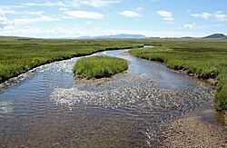
The river just after it passes under
Highway 24 near Hartsel.
369:. It descends to the southeast in a narrow valley along
334:, the intermontane grassland basin located between the
377:, emerging into the northwest end of South Park at
289:
284:
274:
235:
222:
212:
169:
157:
149:
140:
123:
46:. Unsourced material may be challenged and removed.
389:to the south, running along the western side of
330:. The river provides part of the drainage of
8:
106:Learn how and when to remove this message
463:United States Department of the Interior
440:
404:The river was a significant source of
120:
7:
44:adding citations to reliable sources
454:Geographic Names Information System
14:
449:"Middle Fork South Platte River"
353:The river rises in northwestern
129:
55:"Middle Fork South Platte River"
20:
519:Rivers of Park County, Colorado
514:Tributaries of the Platte River
459:United States Geological Survey
31:needs additional citations for
316:Middle Fork South Platte River
237: • coordinates
171: • coordinates
124:Middle Fork South Platte River
1:
387:South Fork South Platte River
230:South Fork South Platte River
141:Physical characteristics
280:8,776 ft (2,675 m)
276: • elevation
224: • location
159: • location
535:
429:List of rivers of Colorado
492:, accessed March 25, 2011
208:
145:
128:
361:along the north side of
318:is a tributary of the
259:39.01111°N 105.74028°W
193:39.37111°N 106.12778°W
385:to the north and the
164:Park County, Colorado
264:39.01111; -105.74028
198:39.37111; -106.12778
40:improve this article
285:Basin features
255: /
189: /
509:Rivers of Colorado
488:2012-03-29 at the
413:Colorado Gold Rush
359:continental divide
320:South Platte River
312:
311:
116:
115:
108:
90:
526:
493:
483:The National Map
479:
473:
472:
470:
469:
445:
270:
269:
267:
266:
265:
260:
256:
253:
252:
251:
248:
228:Confluence with
204:
203:
201:
200:
199:
194:
190:
187:
186:
185:
182:
172:
160:
133:
121:
111:
104:
100:
97:
91:
89:
48:
24:
16:
534:
533:
529:
528:
527:
525:
524:
523:
499:
498:
497:
496:
490:Wayback Machine
480:
476:
467:
465:
447:
446:
442:
437:
425:
399:U.S. Highway 24
371:State Highway 9
365:, just west of
344:Rocky Mountains
301:
277:
263:
261:
257:
254:
249:
246:
244:
242:
241:
238:
225:
197:
195:
191:
188:
183:
180:
178:
176:
175:
170:
158:
136:
119:
112:
101:
95:
92:
49:
47:
37:
25:
12:
11:
5:
532:
530:
522:
521:
516:
511:
501:
500:
495:
494:
474:
439:
438:
436:
433:
432:
431:
424:
421:
383:Tarryall Creek
340:Mosquito Range
310:
309:
291:
287:
286:
282:
281:
278:
275:
272:
271:
239:
236:
233:
232:
226:
223:
220:
219:
216:
210:
209:
206:
205:
173:
167:
166:
161:
155:
154:
151:
147:
146:
143:
142:
138:
137:
134:
126:
125:
117:
114:
113:
28:
26:
19:
13:
10:
9:
6:
4:
3:
2:
531:
520:
517:
515:
512:
510:
507:
506:
504:
491:
487:
484:
478:
475:
464:
460:
456:
455:
450:
444:
441:
434:
430:
427:
426:
422:
420:
418:
414:
410:
407:
402:
400:
396:
392:
388:
384:
380:
376:
372:
368:
364:
363:Mount Lincoln
360:
356:
351:
349:
346:southwest of
345:
341:
337:
333:
329:
328:United States
325:
321:
317:
308:
304:
299:
295:
292:
288:
283:
279:
273:
268:
240:
234:
231:
227:
221:
217:
215:
211:
207:
202:
174:
168:
165:
162:
156:
152:
148:
144:
139:
132:
127:
122:
110:
107:
99:
88:
85:
81:
78:
74:
71:
67:
64:
60:
57: –
56:
52:
51:Find sources:
45:
41:
35:
34:
29:This article
27:
23:
18:
17:
477:
466:. Retrieved
452:
443:
403:
367:Hoosier Pass
352:
315:
313:
294:South Platte
102:
96:January 2011
93:
83:
76:
69:
62:
50:
38:Please help
33:verification
30:
411:during the
355:Park County
336:Front Range
307:Mississippi
290:Progression
262: /
250:105°44′25″W
196: /
184:106°07′40″W
503:Categories
468:2011-01-26
435:References
332:South Park
247:39°00′40″N
181:39°22′16″N
66:newspapers
357:, at the
486:Archived
423:See also
391:Red Hill
379:Fairplay
338:and the
324:Colorado
303:Missouri
395:Hartsel
342:in the
326:in the
80:scholar
406:placer
348:Denver
298:Platte
218:
153:
150:Source
82:
75:
68:
61:
53:
373:past
214:Mouth
118:River
87:JSTOR
73:books
409:gold
375:Alma
314:The
59:news
417:Ute
42:by
505::
461:,
457:.
451:.
401:.
350:.
471:.
305:—
300:—
296:—
109:)
103:(
98:)
94:(
84:·
77:·
70:·
63:·
36:.
Text is available under the Creative Commons Attribution-ShareAlike License. Additional terms may apply.