182:
1232:
720:
49:
732:
174:
42:
377:. To begin with, material was deposited that had been washed into the sea from the land; then the sea level rose and limestone-forming organisms began to populate it. Marine deposits that were near the shore, made of limestones, dolomitic rocks and breccias, are still layered in places in a narrow strip of land between Langlehn and Igelskar (Reichenhall Strata). Because they weather relatively easily, they form
914:
408:) and greenish tuffs occur in these limestones that indicate the presence of nearby Stromboli-like volcanoes. This sequence arose from a shallow, oxygen-rich marine environment, in which reefs and basins alternated with one another. Some time afterwards the Partnach Strata were formed that are especially attractive in the
498:
At the time of their deposition the rocks of the
Northern Limestone Alps were located several hundred kilometres south of their present position. About 35 million years ago, tectonic forces, that are still active today, began to push these geological units northwards. At that time several kilometres
447:
lived. Their dead, limy skeletons form the most important rock: Wetterstein limestone. This mostly bright white and weather-resistant limestone contrasts strongly with the other rocks. It forms the striking summits of the
Mieminger and Wetterstein Mountains, not least the Sonnenspitze, Igelskopf and
558:
The major change to the landscape since the last ice age was the Fern Pass landslide that filled the valley between
Biberwier and Nassereith to a depth of 200 metres. Since then the scenery has changed very little. Occasionally there are rock avalanches, landslides or mudflows. Water, ice and wind
340:
In relation to the total age of the Earth, which is about 4,500 million years, the rocks of the
Mieminger Mountains come mainly from two relatively small windows of time. One of these began about 250 million years ago and ended 130 million years ago (during the
181:
305:
and today are adjacent to one together. The
Mieminger Mountains are located in one of these stacks: the Inn Valley or Inntal Stack. Almost all the rocks in the Mieminger range were formed at one stage on the seabed and consist of
499:
of rock and several hundred metres of water lay on top of the rocks visible today. As a result there was a massive overlapping pressure that prevented the formations underneath from breaking up as they were pushed together.
654:–Oberweidach and past the Simmelberg to the north to the Drahnbach. The eastern boundary runs along the stream of Drahnbach and over the Seefelder saddle, then downhill along the Niederbach to its confluence with the Inn.
661:
links the
Mieminger range with the Lechtal Alps. The unnamed saddle near the Ehrwalder Alm is the link between the Mieminger Chain and the Wetterstein. The Seefelder saddle links the Mieminger Chain with the Karwendel.
550:
Glacier was about 1,000 metres thick and, after the ice had melted about 10,000 years ago, it left behind that typical feature of ice age terrain: moraines. The remnants of the ice sheet in the mountains formed classic
860:: height: 1,506 m, self-catering (special lock), not managed, key obtainable from the Munich Alpine Club, 16 mattress spaces, base: Wildermieming, duration from Wildermieming: 2 hours
262:
in the extreme east receive large numbers of visitors, the less developed central area remains very quiet. The Hohe Munde is also a popular and challenging ski touring destination.
872:: height: 1,920 m, managed from the start of June to October, 80 mattress spaces, winter room with 10 bedspaces, base: Ehrwald, duration from the Ehrwalder Alm (cable car): 2 hours
404:- which, when struck, often smell slightly of bitumen and are striking because of their uneven, irregular surface layers. Irregularly shaped, dark brown to black hornfels nodules (
490:
whose deposits are of less importance. They were largely carried off in the course of the millions of years and only still exist in a few sheltered sites or underground.
1266:
1060:
534:
The relatively recent deposits in the up to 70 metre deep moors are predominantly gravels, shingles, clay, humus and peat; the latter even being used at one time near
710:
The hills between
Seefeld and the Buchener Saddle near the Hohe Munde are not described in the guide. Orographically they are definitely part of the Mieminger Chain.
559:
continue to attack the rocks, transporting their debris down the mountain torrents into the valleys and reminding us that these geological processes continue today.
293:
The
Mieminger Mountains lie in a particularly interesting region from a geological standpoint. Between the peaks of the Sonnenspitze, Wetterstein and Daniel, three
607:
128:
899:
Stage R47 runs from the
Coburger Hut through Biberwier to the Wolfratshauser Hut. The second part of this stage runs through the Lechtal Alps.
1053:
1023:
1256:
997:
866:: height: 2,040 m, self-catering (Alpine Club key), not managed, 5 mattress spaces, base: Ehrwald, duration from Ehrwald: 3.5 hours
1271:
1261:
1046:
935:
931:
978:
950:
783:
In the
Mieminger Mountains there are over 60 named peaks with spot heights. The best known, in order of height, are the:
41:
1231:
896:
Stage R46 runs from the Reintalanger Hut to the Coburger Hut. The first part of this stage runs through the Wetterstein.
121:
885:, a cross-border long-distance trail with five sections through the whole Alps, runs through the Mieminger Mountains.
719:
957:
924:
646:. To the north its boundary runs from Ehrwald along the Gaisbach stream and the Ehrwalder Alm into the Gaistal (
1106:
964:
1191:
1070:
357:). There are no older rocks that predate those from in the first window, and the more recent ones have been
217:
1276:
1251:
1176:
946:
808:
724:
245:
1146:
373:
The mountains' geological history began in tropical climes, on the edge of a broad and shallow sea: the
233:
1013:
1181:
1131:
863:
266:
1186:
1116:
693:) (Wampeter Schrofen, Schartenkopf, Sonnenspitze, Breitenkopf, Igelsköpfe, Tajaköpfe, Drachenköpfe)
731:
479:
1096:
1038:
589:
229:
820:
543:
350:
241:
173:
522:). At the same time the rocks were uplifted. Taken together these processes are referred to as
1156:
1028:
1019:
857:
814:
802:
631:
298:
249:
518:
Basin or the Leutasch River are the front of such a nappe, also called the Inn Valley Stack (
1196:
1171:
1136:
1101:
1091:
282:
971:
853:
There are three Alpine Club huts in the Mieminger Mountains, only one of which is managed.
1161:
1126:
647:
486:
Period in the Mieminger Chain ends with Wetterstein limestone and is then followed by the
311:
294:
201:
1206:
400:
During the next time period, a thick sequence of dark limestones was formed - the Alpine
1081:
700:) (Hintereggenkamm, Judenkopfkamm, Schlosskopfkamm, Wankspitzen, Arzbergkamm, Höllkopf)
577:
362:
160:
610:, published in 1984, the Mieminger and Wetterstein ranges are shown as a single unit.
1245:
1201:
1111:
1086:
378:
374:
114:
514:). For example, the steep slopes falling away from the Mieminger Mountains into the
1221:
1216:
1151:
1121:
869:
583:
503:
254:
221:
670:
The Alpine Club Guide divides the Mieminger Chain into the following sub-groups:
349:
Periods), whilst the second window is the last 10,000 years since the end of the
1211:
913:
746:
619:
571:
567:
The Mieminger Chain borders on the following other mountain ranges of the Alps:
453:
421:
401:
58:
17:
882:
826:
790:
736:
683:
679:
635:
440:
319:
278:
259:
232:. This sub-group is somewhat in the shadows of its more famous neighbour, the
143:
130:
1141:
658:
639:
595:
542:). The finishing touches to the mountains and valleys took place during the
457:
435:
began to develop in the shallow waters of the sea, in which small coralline
425:
315:
307:
237:
456:
are largely unvegetated and this tends to characterise the scene above the
448:
Zugspitze. Because Wetterstein limestone contains few plant nutrients, its
892:) of the Via Alpina has two stages running through the range as follows:
837:
761:
651:
487:
483:
354:
346:
342:
331:
323:
274:
236:
to the north. Whilst the region around the Coburger Hut and the lakes of
643:
547:
535:
523:
515:
358:
327:
270:
225:
796:
623:
552:
464:
86:
730:
718:
507:
449:
444:
436:
302:
180:
172:
627:
622:
forms the boundary of the range from the Niederbach stream near
472:
468:
432:
334:
1042:
907:
475:
538:
for the lead-zinc smelter of the Silberleithen cooperative (
555:, in which the last moraines of the glacier have survived.
735:
The Hochplattig (2,768 m) and Hochwand (2,719 m) from the
626:
upstream as far as its confluence with the Gurglbach near
742:
The 10 highest peaks in the Mieminger Chain are the:
836:
In the area of the 1,789 m high Marienbergjoch is a
938:. Unsourced material may be challenged and removed.
159:
120:
110:
102:
97:
85:
77:
72:
29:
273:on the western side of the range. Busses run from
482:and in the rest of the Mieminger Mountains. The
608:Alpine Club classification of the Eastern Alps
1054:
8:
420:. They consist of light-coloured limestone
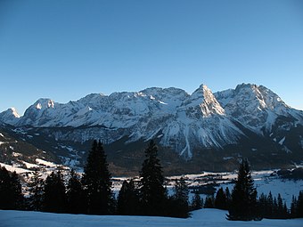
188:from the valley between Ehrwald and Lermoos
1061:
1047:
1039:
26:
998:Learn how and when to remove this message
502:As a result of the compressional forces,
277:on the southern side of the mountains to
1267:Mountain ranges of Tyrol (federal state)
506:occurred piling the rock layers up into
630:. Its western boundary runs along the
463:A feature of Wetterstein limestone is
301:, were piled on top of one another as
177:Northern aspect of the Mieminger Chain
92:2,768 m above sea level (AA)
361:by wind, weather and water since the
48:
7:
936:adding citations to reliable sources
1033:Wetterstein- und Mieminger Gebirge
25:
773:Hochplattig, Signalgipfel, 2698 m
1230:
912:
297:meet that, during the course of
47:
40:
1018:Verlag Rother Ottobrunn, 1989,
923:needs additional citations for
767:Hochwand, Südwestgipfel, 2715 m
727:(2,412 m) from the Coburger Hut
776:Westliche Mitterspitze, 2693 m
758:Westliche Griesspitzen, 2741 m
216:), is a mountain range of the
1:
779:Mittlere Mitterspitze, 2686 m
770:Östliche Mitterspitze, 2705 m
755:Östliche Griesspitzen, 2747 m
703:Tschirgant-Simmering massif (
752:Hochplattig, Westeck, 2749 m
365:about 35 million years ago.
265:Public transport links: The
258:over the Tajakante) and the
224:. It is located entirely in
1257:Mountain ranges of the Alps
1293:
705:Tschirgant-Simmering-Stock
1228:
1077:
707:) (Tschirgant, Simmering)
34:
650:) and continues through
314:. In addition there are
1272:Innsbruck-Land District
1262:Northern Limestone Alps
1071:Northern Limestone Alps
1069:Mountain ranges of the
764:, Nordostgipfel, 2719 m
546:. The ice sheet of the
218:Northern Limestone Alps
167:Northern Limestone Alps
63:within the Eastern Alps
61:and Mieminger Mountains
1177:Upper Austrian Prealps
809:Ehrwalder Sonnenspitze
739:
728:
725:Ehrwalder Sonnenspitze
696:Southern side ridges (
689:Northern side ridges (
526:or mountain building.
478:. These were mined at
246:Ehrwalder Sonnenspitze
205:
189:
178:
749:, main summit, 2768 m
734:
722:
691:Nördliche Seitenkämme
184:
176:
1182:Rax-Schneeberg Group
932:improve this article
877:Long-distance trails
698:Südliche Seitenkämme
634:valley from Imst to
310:and its derivative,
228:within the state of
1187:Salzburg Slate Alps
563:Neighbouring ranges
391:Biberwierer Scharte
210:Mieminger Mountains
140: /
1097:Berchtesgaden Alps
1014:Alpenvereinsführer
832:Simmering, 2,096 m
787:Grünstein, 2,666 m
740:
729:
580:(to the southwest)
418:Wampertem Schrofen
190:
179:
73:Highest point
1239:
1238:
1029:Alpenvereinskarte
1024:978-3-7633-1099-9
1011:Rudolf Wutscher:
1008:
1007:
1000:
982:
815:Hinterer Tajakopf
803:Vorderer Tajakopf
618:To the south the
414:Marienbergspitzen
330:(rauhwackes) and
299:mountain building
267:Außerfern Railway
250:Vorderer Tajakopf
214:Mieminger Gebirge
194:Mieming(er) Range
171:
170:
144:47.35°N 10.9834°E
122:Range coordinates
16:(Redirected from
1284:
1234:
1102:Brandenberg Alps
1092:Bavarian Prealps
1063:
1056:
1049:
1040:
1016:Mieminger Kette.
1003:
996:
992:
989:
983:
981:
940:
916:
908:
295:geological units
283:Seefeld in Tirol
163:
155:
154:
152:
151:
150:
145:
141:
138:
137:
136:
133:
93:
56:Location of the
51:
50:
44:
27:
21:
1292:
1291:
1287:
1286:
1285:
1283:
1282:
1281:
1242:
1241:
1240:
1235:
1226:
1127:Gutenstein Alps
1073:
1067:
1004:
993:
987:
984:
947:"Mieming Range"
941:
939:
929:
917:
906:
879:
864:Breitenkopf Hut
851:
846:
717:
668:
648:Leutascher Ache
616:
565:
544:Würm glaciation
532:
504:thrust faulting
496:
371:
351:Würm glaciation
291:
206:Mieminger Kette
198:Mieminger Chain
161:
148:
146:
142:
139:
134:
131:
129:
127:
126:
91:
68:
67:
66:
65:
64:
54:
53:
52:
23:
22:
18:Mieminger Chain
15:
12:
11:
5:
1290:
1288:
1280:
1279:
1274:
1269:
1264:
1259:
1254:
1244:
1243:
1237:
1236:
1229:
1227:
1225:
1224:
1219:
1214:
1209:
1204:
1199:
1194:
1189:
1184:
1179:
1174:
1169:
1164:
1159:
1154:
1149:
1144:
1139:
1134:
1129:
1124:
1119:
1114:
1109:
1107:Bregenz Forest
1104:
1099:
1094:
1089:
1084:
1078:
1075:
1074:
1068:
1066:
1065:
1058:
1051:
1043:
1037:
1036:
1026:
1006:
1005:
920:
918:
911:
905:
902:
901:
900:
897:
888:The Red Path (
878:
875:
874:
873:
867:
861:
850:
847:
845:
842:
834:
833:
830:
824:
818:
812:
806:
800:
794:
788:
781:
780:
777:
774:
771:
768:
765:
759:
756:
753:
750:
716:
713:
712:
711:
708:
701:
694:
687:
667:
664:
615:
612:
600:
599:
593:
592:(to the north)
587:
581:
575:
574:(to the south)
564:
561:
531:
528:
512:Gesteinsdecken
495:
494:Alpine Orogeny
492:
370:
367:
363:Alpine orogeny
290:
287:
169:
168:
165:
157:
156:
149:47.35; 10.9834
124:
118:
117:
112:
108:
107:
104:
100:
99:
95:
94:
89:
83:
82:
79:
75:
74:
70:
69:
55:
46:
45:
39:
38:
37:
36:
35:
32:
31:
24:
14:
13:
10:
9:
6:
4:
3:
2:
1289:
1278:
1277:Imst District
1275:
1273:
1270:
1268:
1265:
1263:
1260:
1258:
1255:
1253:
1252:Mieming Range
1250:
1249:
1247:
1233:
1223:
1220:
1218:
1215:
1213:
1210:
1208:
1205:
1203:
1202:Totes Gebirge
1200:
1198:
1195:
1193:
1192:Salzkammergut
1190:
1188:
1185:
1183:
1180:
1178:
1175:
1173:
1172:Mürzsteg Alps
1170:
1168:
1167:Mieming Range
1165:
1163:
1160:
1158:
1155:
1153:
1150:
1148:
1145:
1143:
1140:
1138:
1135:
1133:
1130:
1128:
1125:
1123:
1120:
1118:
1115:
1113:
1112:Chiemgau Alps
1110:
1108:
1105:
1103:
1100:
1098:
1095:
1093:
1090:
1088:
1087:Ammergau Alps
1085:
1083:
1080:
1079:
1076:
1072:
1064:
1059:
1057:
1052:
1050:
1045:
1044:
1041:
1034:
1030:
1027:
1025:
1021:
1017:
1015:
1010:
1009:
1002:
999:
991:
980:
977:
973:
970:
966:
963:
959:
956:
952:
949: –
948:
944:
943:Find sources:
937:
933:
927:
926:
921:This article
919:
915:
910:
909:
903:
898:
895:
894:
893:
891:
886:
884:
876:
871:
868:
865:
862:
859:
856:
855:
854:
848:
843:
841:
839:
831:
828:
825:
822:
819:
816:
813:
810:
807:
804:
801:
798:
795:
792:
789:
786:
785:
784:
778:
775:
772:
769:
766:
763:
760:
757:
754:
751:
748:
745:
744:
743:
738:
733:
726:
721:
714:
709:
706:
702:
699:
695:
692:
688:
685:
681:
677:
673:
672:
671:
666:Sub-divisions
665:
663:
660:
655:
653:
649:
645:
641:
638:and over the
637:
633:
629:
625:
621:
613:
611:
609:
605:
598:(to the east)
597:
594:
591:
588:
586:(to the west)
585:
582:
579:
576:
573:
570:
569:
568:
562:
560:
556:
554:
549:
545:
541:
537:
529:
527:
525:
521:
517:
513:
509:
505:
500:
493:
491:
489:
485:
481:
477:
474:
470:
466:
461:
459:
455:
451:
446:
442:
438:
434:
429:
427:
423:
419:
415:
411:
407:
403:
398:
396:
392:
388:
384:
380:
376:
375:Alpine Tethys
368:
366:
364:
360:
356:
353:(part of the
352:
348:
344:
338:
336:
333:
329:
325:
321:
317:
313:
309:
304:
300:
296:
288:
286:
284:
280:
276:
272:
268:
263:
261:
257:
256:
252:with its new
251:
247:
244:in the west (
243:
239:
235:
231:
227:
223:
219:
215:
211:
207:
203:
199:
195:
187:
186:Mieming range
183:
175:
166:
164:
158:
153:
125:
123:
119:
116:
113:
109:
105:
101:
96:
90:
88:
84:
80:
76:
71:
62:
60:
43:
33:
30:Mieming Range
28:
19:
1222:Ybbstal Alps
1217:Vienna Woods
1207:Türnitz Alps
1166:
1152:Lechtal Alps
1122:Ennstal Alps
1032:
1012:
994:
985:
975:
968:
961:
954:
942:
930:Please help
925:verification
922:
889:
887:
880:
870:Coburger Hut
852:
835:
782:
741:
704:
697:
690:
678:) (from the
675:
674:Main crest (
669:
656:
617:
603:
601:
584:Lechtal Alps
566:
557:
540:Gewerkschaft
539:
533:
519:
511:
501:
497:
480:Silberleithe
467:-containing
462:
454:talus slopes
430:
417:
413:
412:between the
409:
405:
402:muschelkalks
399:
394:
390:
386:
382:
372:
369:Mesozoic Era
339:
326:, carbonate
292:
264:
255:klettersteig
253:
222:Eastern Alps
213:
209:
197:
193:
191:
185:
162:Parent range
57:
1212:Wetterstein
1147:Lechquellen
1082:Allgäu Alps
747:Hochplattig
590:Wetterstein
578:Ötztal Alps
572:Stubai Alps
520:Inntaldecke
441:haptophytes
422:interbedded
234:Wetterstein
147: /
81:Hochplattig
59:Wetterstein
1246:Categories
1132:Hochschwab
1035:, 1:25.000
988:April 2011
958:newspapers
904:References
883:Via Alpina
827:Wankspitze
821:Tschirgant
791:Hohe Munde
737:Hohe Munde
684:Hochwannig
680:Hohe Munde
636:Nassereith
614:Boundaries
426:argillites
320:argillites
316:sandstones
279:Mittenwald
260:Hohe Munde
242:Drachensee
135:10°59′00″E
132:47°21′00″N
1142:Karwendel
1117:Dachstein
829:, 2,208 m
823:, 2,370 m
817:, 2,409 m
811:, 2,417 m
805:, 2,452 m
799:, 2,493 m
793:, 2,659 m
676:Hauptkamm
659:Fern Pass
640:Fern Pass
620:River Inn
596:Karwendel
458:tree line
389:like the
308:limestone
269:stops at
238:Seebensee
98:Geography
87:Elevation
890:Rote Weg
858:Alplhaus
838:ski area
762:Hochwand
652:Leutasch
632:Gurgltal
530:Ice ages
488:Jurassic
484:Triassic
395:Tajatörl
355:Cenozoic
347:Jurassic
343:Triassic
332:volcanic
328:breccias
324:hornfels
312:dolomite
275:Leutasch
1157:Leogang
972:scholar
844:Tourism
682:to the
644:Ehrwald
602:In the
553:cirques
548:Loisach
536:Lermoos
524:orogeny
516:Ehrwald
410:Schwärz
406:Knauern
393:or the
383:Scharte
289:Geology
271:Ehrwald
226:Austria
220:in the
106:Austria
103:Country
1197:Tennen
1137:Kaiser
1022:
974:
967:
960:
953:
945:
797:Wannig
624:Inzing
606:, the
508:nappes
465:silver
445:corals
443:) and
431:Next,
385:) and
359:eroded
303:nappes
208:) or
202:German
1162:Lofer
1031:4/2:
979:JSTOR
965:books
715:Peaks
450:scree
437:algae
433:reefs
424:with
387:Törle
335:tuffs
230:Tyrol
115:Tyrol
111:State
1020:ISBN
951:news
881:The
849:Huts
723:The
657:The
628:Imst
473:zinc
471:and
469:lead
452:and
416:and
379:cols
345:and
281:and
248:and
240:and
192:The
78:Peak
934:by
642:to
604:AVE
476:ore
1248::
840:.
460:.
428:.
397:.
337:.
322:,
318:,
285:.
204::
196:,
1062:e
1055:t
1048:v
1001:)
995:(
990:)
986:(
976:·
969:·
962:·
955:·
928:.
686:)
510:(
439:(
381:(
212:(
200:(
20:)
Text is available under the Creative Commons Attribution-ShareAlike License. Additional terms may apply.