29:
192:
197:
203:
517:
80:
73:
685:
1042:. A group of hills between Astro Glacier and Nimrod Glacier in the northwest part of the Miller Range. Mapped by the USGS from tellurometer surveys and Navy air photos, 1960-62. Named by US-ACAN for Dr. Mort D. Turner of the National Science Foundation who has been Program Manager for Polar Earth Sciences, Division of Polar Programs, since 1959. Turner studied the geology of the dry valley areas near McMurdo Sound, 1959-60, and in several subsequent seasons served as USARP Representative in Antarctica.
53:
1164:. A small bluff or promontory on the east side of Miller Range, overlooking Marsh Glacier 5 miles (8.0 km) south of Corner Nunatak. Named by US-ACAN for Izak C. Rust, professor of geology, University of Port Elizabeth, South Africa. Rust was international exchange scientist with the Ohio State University Geological Expedition, 1969–70, and with John Gunner collected geological samples at this bluff.
508:. A semi-circular glacial cirque, 1 mile (1.6 km) wide, at the south end of Macdonald Bluffs in Miller Range. It indents the cliff, at the north side of the terminus of Argo Glacier where the latter enters Marsh Glacier. So named by the Ohio State University Geological Party, 1967-68, because the granite cliffs of the cirque have a bright pink to red color in certain lighting.
638:. A hill in the south part of Augen Bluffs, Miller Range. The hill rises 100–200 metres (330–660 ft) above the west side of Marsh Glacier and is connected to Augen Bluffs by a col 10–20 metres (33–66 ft) lower than the height of the hill. So named by the Ohio State University Geological Party of 1967–68 because an isoclinal fold is well exposed on the side of the hill.
1586:
432:. A semi-circular glacial cirque 1 mile (1.6 km) wide in the Miller Range. It is carved into Macdonald Bluffs at the southeast base of Kreiling Mesa. So named by the Ohio State University Geological Party of 1967–68, because the granite cliffs surrounding the cirque are cut by numerous black dikes.
309:
and of continental origin. The Miller Range differs from its neighbors in being composed only of the basement complex, which holds regional metamorphic rocks of the Nimrod Group, with Hope
Granite intrusions. Metamorphic rocks of the Nimrod Group include mica schists, metaquartzites, banded gneisses,
882:. Prominent east-facing bluffs between Argosy and Argo Glaciers in the Miller Range, descending to the Marsh Glacier. Mapped by the New Zealand Southern Party of the CTAE (1956-58) and named for W.J.P. Macdonald, IGY scientist at Scott Base in 1957. Not: Macdonald Cliffs.
920:. A distinctive, partially ice-covered mesa at the S side of the mouth of Argosy Glacier in the Miller Range. Named by US-ACAN for Lee W. Kreiling, USARP traverse engineer at NAF McMurdo, winter 1961, Ellsworth Land Traverse, 1961-62, and Roosevelt Island, 1962-63.
768:. A partially ice-covered ridge, 5 miles (8.0 km) long, extending northward from Martin Dome to the southern edge of Argosy Glacier in the Miller Range. Named by US-ACAN after Charles R. Greene, Jr., USARP ionospheric scientist at the South Pole Station, 1958.
246:. It runs from north to south, and is about 80 kilometres (50 mi) long and up to 30 kilometres (19 mi) wide. The maximum elevation above the ice sheet is about 1,700 metres (5,600 ft). There are signs of glaciation on the highest points of the range.
676:. A peak in the Miller Range overlooking Marsh Glacier, forming the eastern salient in the bluffs southward of Argo Glacier. Observed in December 1957 by the New Zealand Southern Party of the CTAE (1956-58). Named for H. Orr, IGY scientist at Scott Base in 1957.
1126:. A snow saddle 4 miles (6.4 km) northeast of Aurora Heights, between Argosy and Skua Glaciers. Discovered and named by the northern party of NZGSAE (1961-62), who found the deep soft snow here made snowshoeing the best method of travel.
806:. An elevated, snow-covered prominence between Argosy Glacier and Argo Glacier in the Miller Range. Sighted in December 1957 by the New Zealand Southern Party of the CTAE. Named for L. Martin, leader at Scott Base in 1958. Not: Martins Dome.
470:. A glacial cirque 0.5 miles (0.80 km) wide along the east wall of Ascent Glacier in the Miller Range. It was named by the Ohio State University Geological Party of 1967–68 because the cirque was the scene of a game of ice hockey.
600:. Rock bluffs between Orr Peak and Isocline Hill along the west side of Marsh Glacier, in the Miller Range. So named by the Ohio State University Geological Party, 1967-68, because rocks of the locality include augengneiss.
1590:
562:. Prominent ice-free bluffs marking the southern extremity of the Miller Range. Mapped in December 1957, and named by the New Zealand southern party of the CTAE (1956-58) for V. Gerard, IGY scientist at Scott Base in 1957.
966:. Prominent heights 5 miles (8.0 km) long, bordering the north side of Argosy Glacier. Named by the NZGSAE (1961–62) for the Aurora, the ship of the Ross Sea Party of the British Trans-Antarctic Expedition (1914-17).
300:
The range is in the
Beardmore-Nimrod Glacier area, which has a basement complex of igneous, metamorphic and sedimentary rocks. This is unconformably overlain by a thick sequence of sedimentary rocks, mostly from the
1004:. An ice-covered, dome-shaped mountain, 2,470 metres (8,100 ft) high. So named by the NZGSAE (1961-62) because its heights offer an extensive view of Nimrod Glacier and were used as a survey station.
844:. A mainly ice-free valley 5 miles (8.0 km) long, just west of Kreiling Mesa in the Miller Range. Named by US-AC AN for John S. Ong, USARP traverse engineer on the South Pole Traverse (1962-63).
730:. A mainly ice-free ridge, 5 miles (8.0 km) long, bordering the west side of Ascent Glacier in the Miller Range. Named by US-ACAN for Frederick M. Milan, physiologist at Little America V, 1957.
1637:
Payne, Justin L.; Hand, Martin; Barovich, Karin M.; Reid, Anthony; Evans, David A. D. (2009), "Correlations and reconstruction models for the 2500–1500 Ma evolution of the Mawson
Continent",
1206:
at the extreme northeast corner of the Miller Range, between Nimrod
Glacier and Marsh Glacier. Named by the northern party of the NZGSAE (1961-62). Not: Corner Peak.
249:
The Miller Range is separated by about 20 kilometres (12 mi) from the adjacent ranges of the
Transantarctic Mountains by the Nimrod and Marsh glaciers. The
1594:
227:
72:
1663:
258:
28:
101:
191:
94:
1088:. Seen by the northern party of the NZGSAE (1961-62) and so named because of its resemblance to a three-cornered hat.
310:
augen gneisses and marbles, all mostly derived from sedimentary sources, and amphibolites derived from basaltic rocks.
196:
202:
1174:
1136:
1098:
1052:
1014:
976:
938:
892:
854:
816:
778:
740:
702:
648:
610:
572:
534:
480:
442:
404:
141:
516:
239:
323:
294:
286:
684:
381:, also flows east into Marsh Glacier, and divides the central part of the range from the northern part.
373:, which flows east into Marsh Glacier, divides the southern part of the range from the central part.
219:
52:
350:
345:
278:
33:
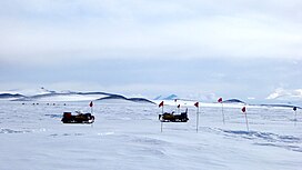
The ANSMET team searches for meteorites on the blue ice field in the Miller Range 3 January 2016
340:
1642:
266:
520:
Aboard snow machines, the team traverses a pass toward the blue ice field in the distance
1621:
378:
374:
366:
290:
254:
243:
174:
170:
1657:
1081:
386:
362:
282:
250:
178:
281:. There is evidence that suggests that the Miller Range terrain was accreted to the
1568:
1085:
382:
370:
262:
1602:
223:
293:–Nimrod Orogeny, with a suture zone that may be at or near the location of the
182:
1189:
1176:
1151:
1138:
1113:
1100:
1067:
1054:
1029:
1016:
991:
978:
953:
940:
907:
894:
869:
856:
831:
818:
793:
780:
755:
742:
717:
704:
663:
650:
625:
612:
587:
574:
549:
536:
495:
482:
457:
444:
419:
406:
389:
flow northeast through the northern portion of the range into Marsh
Glacier.
156:
143:
116:
103:
369:
to the west, both of which flow north and converge just north of the range.
335:
306:
302:
1203:
257:
to the west both flow north and converge just north of the range. The
1646:
261:
is east of the Miller Range, on the other side of Marsh
Glacier. The
44:
1604:
Petrography of
Metamomorphic Rocks from the Miller Range, Antarctica
683:
515:
692:
The
Central section is between Argo Glacier and Argosy Glacier.
688:
Blue ice field in the Miller Range, near the edge of a moraine.
269:
to the northwest, both on the other side of the Nimrod
Glacier.
1641:, vol. 323, Geological Society, London, pp. 319–355,
1238:
1236:
1234:
177:
for 80 km (50 mi) along the western edge of the
1221:
1219:
928:
The Northern section is to the north of Argosy Glacier.
1257:
1255:
1253:
1251:
524:
The southern section is to the south of Argo Glacier.
1576:(2 ed.), United States Board on Geographic Names
1285:
1273:
1080:. Snow-covered peak, 2,320 m, on the ridge between
93:
60:
43:
38:
21:
230:(1958) who, with G.W. Marsh, mapped this area.
8:
1242:
218:The range is named for J.H. "Bob", now Sir
1626:, USGS United States Geologic Survey, 1960
51:
18:
1595:United States Board on Geographic Names
1549:
1537:
1525:
1513:
1501:
1489:
1477:
1465:
1453:
1441:
1429:
1417:
1405:
1393:
1381:
1369:
1357:
1345:
1333:
1321:
1225:
1215:
228:Commonwealth Trans-Antarctic Expedition
1309:
1297:
1261:
7:
79:
1593:from websites or documents of the
49:3,000 m (9,800 ft)
14:
1570:Geographic Names of the Antarctic
277:The Miller Range was part of the
1589: This article incorporates
1584:
201:
195:
190:
78:
71:
27:
289:Craton during the 1730–1690 Ma
1567:Alberts, Fred G., ed. (1995),
1:
1664:Mountain ranges of Oates Land
1610:, Institute of Polar Studies
265:is to the northeast and the
16:Mountain range in Antarctica
351:GPX (secondary coordinates)
238:The Miller Range is in the
1680:
346:GPX (primary coordinates)
321:Map all coordinates using
65:
26:
1601:Gunner, John D. (1969),
377:, fed from the south by
329:Download coordinates as:
240:Transantarctic Mountains
208:Maps of the Miller Range
1591:public domain material
689:
521:
687:
519:
365:lies to the east and
341:GPX (all coordinates)
259:Queen Elizabeth Range
173:extending south from
1639:Special Publications
220:Joseph Holmes Miller
1504:, pp. 764–765.
1186: /
1148: /
1110: /
1064: /
1026: /
988: /
950: /
904: /
866: /
828: /
790: /
752: /
714: /
660: /
622: /
584: /
546: /
492: /
454: /
416: /
242:to the east of the
153: /
113: /
1190:82.867°S 157.650°E
1152:82.933°S 157.700°E
1114:83.050°S 157.600°E
1068:82.983°S 156.800°E
1030:82.967°S 156.300°E
992:83.050°S 156.450°E
954:83.117°S 157.083°E
908:83.217°S 157.900°E
870:83.250°S 157.833°E
832:83.233°S 157.617°E
794:83.300°S 157.200°E
756:83.200°S 157.167°E
718:83.250°S 156.133°E
690:
664:83.483°S 157.817°E
626:83.517°S 157.600°E
588:83.500°S 157.667°E
550:83.617°S 157.250°E
522:
496:83.333°S 157.600°E
458:83.283°S 156.500°E
420:83.233°S 157.950°E
222:, a member of the
157:83.250°S 157.000°E
117:83.250°S 157.000°E
39:Highest point
1286:Payne et al. 2009
1274:Payne et al. 2009
474:Strawberry Cirque
132:
131:
95:Range coordinates
1671:
1649:
1647:10.1144/SP323.16
1633:
1632:
1631:
1617:
1616:
1615:
1609:
1588:
1587:
1583:
1582:
1581:
1575:
1553:
1547:
1541:
1535:
1529:
1523:
1517:
1511:
1505:
1499:
1493:
1487:
1481:
1475:
1469:
1463:
1457:
1451:
1445:
1439:
1433:
1427:
1421:
1415:
1409:
1403:
1397:
1391:
1385:
1379:
1373:
1367:
1361:
1355:
1349:
1343:
1337:
1331:
1325:
1319:
1313:
1307:
1301:
1295:
1289:
1283:
1277:
1271:
1265:
1259:
1246:
1243:Mount Rabot USGS
1240:
1229:
1223:
1201:
1200:
1198:
1197:
1196:
1195:-82.867; 157.650
1191:
1187:
1184:
1183:
1182:
1179:
1163:
1162:
1160:
1159:
1158:
1157:-82.933; 157.700
1153:
1149:
1146:
1145:
1144:
1141:
1125:
1124:
1122:
1121:
1120:
1119:-83.050; 157.600
1115:
1111:
1108:
1107:
1106:
1103:
1079:
1078:
1076:
1075:
1074:
1073:-82.983; 156.800
1069:
1065:
1062:
1061:
1060:
1057:
1041:
1040:
1038:
1037:
1036:
1035:-82.967; 156.300
1031:
1027:
1024:
1023:
1022:
1019:
1003:
1002:
1000:
999:
998:
997:-83.050; 156.450
993:
989:
986:
985:
984:
981:
965:
964:
962:
961:
960:
959:-83.117; 157.083
955:
951:
948:
947:
946:
943:
924:Northern Section
919:
918:
916:
915:
914:
913:-83.217; 157.900
909:
905:
902:
901:
900:
897:
881:
880:
878:
877:
876:
875:-83.250; 157.833
871:
867:
864:
863:
862:
859:
848:Macdonald Bluffs
843:
842:
840:
839:
838:
837:-83.233; 157.617
833:
829:
826:
825:
824:
821:
805:
804:
802:
801:
800:
799:-83.300; 157.200
795:
791:
788:
787:
786:
783:
767:
766:
764:
763:
762:
761:-83.200; 157.167
757:
753:
750:
749:
748:
745:
729:
728:
726:
725:
724:
723:-83.250; 156.133
719:
715:
712:
711:
710:
707:
675:
674:
672:
671:
670:
669:-83.483; 157.817
665:
661:
658:
657:
656:
653:
637:
636:
634:
633:
632:
631:-83.517; 157.600
627:
623:
620:
619:
618:
615:
599:
598:
596:
595:
594:
593:-83.500; 157.667
589:
585:
582:
581:
580:
577:
561:
560:
558:
557:
556:
555:-83.617; 157.250
551:
547:
544:
543:
542:
539:
512:Southern section
507:
506:
504:
503:
502:
501:-83.333; 157.600
497:
493:
490:
489:
488:
485:
469:
468:
466:
465:
464:
463:-83.283; 156.500
459:
455:
452:
451:
450:
447:
431:
430:
428:
427:
426:
425:-83.233; 157.950
421:
417:
414:
413:
412:
409:
279:Mawson Continent
267:Geologists Range
253:to the east and
205:
199:
194:
168:
167:
165:
164:
163:
162:-83.250; 157.000
158:
154:
151:
150:
149:
146:
128:
127:
125:
124:
123:
122:-83.250; 157.000
118:
114:
111:
110:
109:
106:
82:
81:
75:
56:
55:
31:
19:
1679:
1678:
1674:
1673:
1672:
1670:
1669:
1668:
1654:
1653:
1652:
1636:
1629:
1627:
1620:
1613:
1611:
1607:
1600:
1585:
1579:
1577:
1573:
1566:
1562:
1557:
1556:
1548:
1544:
1536:
1532:
1524:
1520:
1512:
1508:
1500:
1496:
1488:
1484:
1476:
1472:
1464:
1460:
1452:
1448:
1440:
1436:
1428:
1424:
1416:
1412:
1404:
1400:
1392:
1388:
1380:
1376:
1368:
1364:
1356:
1352:
1344:
1340:
1332:
1328:
1320:
1316:
1308:
1304:
1296:
1292:
1284:
1280:
1272:
1268:
1260:
1249:
1241:
1232:
1224:
1217:
1212:
1194:
1192:
1188:
1185:
1180:
1177:
1175:
1173:
1172:
1170:
1156:
1154:
1150:
1147:
1142:
1139:
1137:
1135:
1134:
1132:
1118:
1116:
1112:
1109:
1104:
1101:
1099:
1097:
1096:
1094:
1072:
1070:
1066:
1063:
1058:
1055:
1053:
1051:
1050:
1048:
1034:
1032:
1028:
1025:
1020:
1017:
1015:
1013:
1012:
1010:
996:
994:
990:
987:
982:
979:
977:
975:
974:
972:
958:
956:
952:
949:
944:
941:
939:
937:
936:
934:
926:
912:
910:
906:
903:
898:
895:
893:
891:
890:
888:
874:
872:
868:
865:
860:
857:
855:
853:
852:
850:
836:
834:
830:
827:
822:
819:
817:
815:
814:
812:
798:
796:
792:
789:
784:
781:
779:
777:
776:
774:
760:
758:
754:
751:
746:
743:
741:
739:
738:
736:
722:
720:
716:
713:
708:
705:
703:
701:
700:
698:
682:
680:Central section
668:
666:
662:
659:
654:
651:
649:
647:
646:
644:
630:
628:
624:
621:
616:
613:
611:
609:
608:
606:
592:
590:
586:
583:
578:
575:
573:
571:
570:
568:
554:
552:
548:
545:
540:
537:
535:
533:
532:
530:
514:
500:
498:
494:
491:
486:
483:
481:
479:
478:
476:
462:
460:
456:
453:
448:
445:
443:
441:
440:
438:
424:
422:
418:
415:
410:
407:
405:
403:
402:
400:
395:
359:
358:
357:
356:
355:
316:
275:
236:
216:
211:
210:
209:
206:
200:
161:
159:
155:
152:
147:
144:
142:
140:
139:
121:
119:
115:
112:
107:
104:
102:
100:
99:
89:
88:
87:
86:
85:
84:
83:
50:
34:
17:
12:
11:
5:
1677:
1675:
1667:
1666:
1656:
1655:
1651:
1650:
1634:
1618:
1598:
1563:
1561:
1558:
1555:
1554:
1552:, p. 154.
1542:
1540:, p. 638.
1530:
1528:, p. 690.
1518:
1516:, p. 758.
1506:
1494:
1492:, p. 443.
1482:
1470:
1468:, p. 404.
1458:
1456:, p. 451.
1446:
1444:, p. 545.
1434:
1432:, p. 465.
1422:
1420:, p. 293.
1410:
1408:, p. 491.
1398:
1396:, p. 547.
1386:
1384:, p. 365.
1374:
1362:
1360:, p. 274.
1350:
1348:, p. 718.
1338:
1336:, p. 337.
1326:
1324:, p. 189.
1314:
1302:
1290:
1288:, p. 328.
1278:
1276:, p. 321.
1266:
1247:
1230:
1228:, p. 492.
1214:
1213:
1211:
1208:
1169:
1168:Corner Nunatak
1166:
1131:
1128:
1093:
1090:
1047:
1044:
1009:
1006:
971:
968:
933:
932:Aurora Heights
930:
925:
922:
887:
884:
849:
846:
811:
808:
773:
770:
735:
732:
697:
694:
681:
678:
643:
640:
605:
602:
567:
564:
529:
526:
513:
510:
475:
472:
437:
434:
399:
396:
394:
391:
379:Ascent Glacier
375:Argosy Glacier
367:Nimrod Glacier
354:
353:
348:
343:
338:
332:
326:
319:
318:
317:
315:
312:
274:
271:
255:Nimrod Glacier
244:Ross Ice Shelf
235:
232:
215:
212:
207:
189:
188:
187:
175:Nimrod Glacier
171:mountain range
130:
129:
97:
91:
90:
77:
76:
70:
69:
68:
67:
66:
63:
62:
58:
57:
47:
41:
40:
36:
35:
32:
24:
23:
15:
13:
10:
9:
6:
4:
3:
2:
1676:
1665:
1662:
1661:
1659:
1648:
1644:
1640:
1635:
1625:
1624:
1619:
1606:
1605:
1599:
1596:
1592:
1572:
1571:
1565:
1564:
1559:
1551:
1546:
1543:
1539:
1534:
1531:
1527:
1522:
1519:
1515:
1510:
1507:
1503:
1498:
1495:
1491:
1486:
1483:
1480:, p. 34.
1479:
1474:
1471:
1467:
1462:
1459:
1455:
1450:
1447:
1443:
1438:
1435:
1431:
1426:
1423:
1419:
1414:
1411:
1407:
1402:
1399:
1395:
1390:
1387:
1383:
1378:
1375:
1372:, p. 33.
1371:
1366:
1363:
1359:
1354:
1351:
1347:
1342:
1339:
1335:
1330:
1327:
1323:
1318:
1315:
1311:
1306:
1303:
1299:
1294:
1291:
1287:
1282:
1279:
1275:
1270:
1267:
1264:, p. ii.
1263:
1258:
1256:
1254:
1252:
1248:
1244:
1239:
1237:
1235:
1231:
1227:
1222:
1220:
1216:
1209:
1207:
1205:
1199:
1167:
1165:
1161:
1129:
1127:
1123:
1092:Snowshoe Pass
1091:
1089:
1087:
1083:
1082:Astro Glacier
1077:
1045:
1043:
1039:
1007:
1005:
1001:
969:
967:
963:
931:
929:
923:
921:
917:
886:Kreiling Mesa
885:
883:
879:
847:
845:
841:
809:
807:
803:
771:
769:
765:
733:
731:
727:
695:
693:
686:
679:
677:
673:
641:
639:
635:
604:Isocline Hill
603:
601:
597:
565:
563:
559:
528:Gerard Bluffs
527:
525:
518:
511:
509:
505:
473:
471:
467:
436:Hockey Cirque
435:
433:
429:
397:
392:
390:
388:
387:Astro Glacier
384:
380:
376:
372:
368:
364:
363:Marsh Glacier
352:
349:
347:
344:
342:
339:
337:
334:
333:
331:
330:
325:
324:OpenStreetMap
322:
313:
311:
308:
304:
298:
296:
292:
288:
284:
280:
272:
270:
268:
264:
260:
256:
252:
251:Marsh Glacier
247:
245:
241:
233:
231:
229:
226:party of the
225:
221:
213:
204:
198:
193:
186:
184:
180:
179:Marsh Glacier
176:
172:
166:
137:
126:
98:
96:
92:
74:
64:
59:
54:
48:
46:
42:
37:
30:
25:
20:
1638:
1628:, retrieved
1622:
1612:, retrieved
1603:
1578:, retrieved
1569:
1550:Alberts 1995
1545:
1538:Alberts 1995
1533:
1526:Alberts 1995
1521:
1514:Alberts 1995
1509:
1502:Alberts 1995
1497:
1490:Alberts 1995
1485:
1478:Alberts 1995
1473:
1466:Alberts 1995
1461:
1454:Alberts 1995
1449:
1442:Alberts 1995
1437:
1430:Alberts 1995
1425:
1418:Alberts 1995
1413:
1406:Alberts 1995
1401:
1394:Alberts 1995
1389:
1382:Alberts 1995
1377:
1370:Alberts 1995
1365:
1358:Alberts 1995
1353:
1346:Alberts 1995
1341:
1334:Alberts 1995
1329:
1322:Alberts 1995
1317:
1312:, p. 4.
1305:
1300:, p. 1.
1293:
1281:
1269:
1226:Alberts 1995
1171:
1133:
1095:
1086:Skua Glacier
1049:
1046:Tricorn Peak
1011:
1008:Turner Hills
973:
970:Lookout Dome
935:
927:
889:
851:
813:
775:
737:
734:Greene Ridge
699:
691:
645:
607:
569:
566:Augen Bluffs
531:
523:
477:
439:
401:
383:Skua Glacier
371:Argo Glacier
360:
328:
327:
320:
299:
295:Nimrod Group
276:
263:Cobham Range
248:
237:
217:
136:Miller Range
135:
133:
22:Miller Range
1623:Mount Rabot
1310:Gunner 1969
1298:Gunner 1969
1262:Gunner 1969
1193: /
1155: /
1117: /
1071: /
1033: /
995: /
957: /
911: /
873: /
835: /
797: /
772:Martin Dome
759: /
721: /
696:Milan Ridge
667: /
629: /
591: /
553: /
499: /
461: /
423: /
398:Dike Cirque
224:New Zealand
160: /
120: /
1630:2023-12-12
1614:2023-12-12
1580:2023-12-03
1210:References
1130:Rust Bluff
810:Ong Valley
183:Antarctica
61:Geography
45:Elevation
1658:Category
1181:157°39′E
1143:157°42′E
1105:157°36′E
1059:156°48′E
1021:156°18′E
983:156°27′E
945:157°05′E
899:157°54′E
861:157°50′E
823:157°37′E
785:157°12′E
747:157°10′E
709:156°08′E
655:157°49′E
642:Orr Peak
617:157°36′E
579:157°40′E
541:157°15′E
487:157°36′E
449:156°30′E
411:157°57′E
314:Glaciers
307:Triassic
303:Devonian
234:Location
148:157°00′E
108:157°00′E
1560:Sources
1204:nunatak
1178:82°52′S
1140:82°56′S
1102:83°03′S
1056:82°59′S
1018:82°58′S
980:83°03′S
942:83°07′S
896:83°13′S
858:83°15′S
820:83°14′S
782:83°18′S
744:83°12′S
706:83°15′S
652:83°29′S
614:83°31′S
576:83°30′S
538:83°37′S
484:83°20′S
446:83°17′S
408:83°14′S
393:Cirques
273:Geology
169:) is a
145:83°15′S
105:83°15′S
291:Kimban
287:Adélie
283:Gawler
1608:(PDF)
1574:(PDF)
1202:. A
1084:and
385:and
361:The
214:Name
134:The
1643:doi
336:KML
305:to
181:in
1660::
1250:^
1233:^
1218:^
297:.
185:.
1645::
1597:.
1245:.
285:–
138:(
Text is available under the Creative Commons Attribution-ShareAlike License. Additional terms may apply.