49:
208:
223:
274:
in the area. The planned community, named
Amaranth, envisioned as a self-sustaining community with a regional mall, employment centers and eventually home to over 50,000 people, has been placed on hold until at least 2010 due to economic slowdown. The delay, as well as the developer's inability to
258:
companies referred to the area as "Mobile" almost a decade before the first permanent settler in the area in the 1920s. In the 1930s, two railroad cars were used for two separate schoolhouses (one black and one for whites), and the population of local
270:
In 2007, Sonoran Valley was annexed into the city of
Goodyear as part of a 67 square miles (170 km) expansion, part of an agreement with Montage Holdings, a local developer, to develop a
48:
339:"An Archaeological Investigation of the Historic Black Settlement at Mobile, Arizona - Broad-interest volumes in archaeology, anthropology, history, and ethnography - SRI Press"
565:
532:
338:
417:
498:
287:
33° 3' 19" N 112° 16' 16" W (33.055301, -112.271102). The private airstrip is located at 33° 6'43.27"N 112°16'8.66"W (33.111720, -112.269517).
353:
478:
488:
65:
378:
468:
316:
505:
473:
483:
267:
and educational facilities (no education past 8th grade) led to the exodus of most of the original residents and their descendants.
410:
510:
119:
403:
201:
181:
284:
161:
124:
97:
54:
263:
reached about 100. By the 1950s the town was booming with almost 400 inhabitants, but the lack of employment,
493:
296:
230:
215:
275:
meet financial obligations to the city, has forced
Goodyear to cut back on emergency services to the area.
180:
operates a private airport to the north of
Sonoran Valley, used for pilot training by student pilots of
207:
357:
226:
211:
440:
185:
140:
537:
426:
271:
243:
197:
193:
157:
324:
169:
251:
246:
to live. Notable
African-American woman of Mobile, Rebecca Dallis, taught in Casa Grande
260:
559:
250:
1939. Local lore has it that some of its early residents were
African-Americans from
172:, and has a population of less than 100. Sonoran Valley is also home to a number of
107:
80:
67:
264:
222:
177:
131:
255:
173:
165:
112:
395:
221:
206:
136:
399:
354:"Goodyear to cut Sonoran Valley public safety costs nearly 88%"
189:
168:, United States. It is situated about 35 miles southwest of
525:
461:
454:
433:
130:
118:
106:
96:
24:
379:"Delay in Amaranth construction blamed on economy"
156:, is a community in the southern planning area of
19:Goodyear Planning Area in Arizona, United States
242:Mobile was founded in the 1930s as an area for
411:
8:
233:approaching Mobile "Lufthansa pvt" Airfield
566:Former census-designated places in Arizona
458:
418:
404:
396:
21:
533:Arizona State Prison Complex – Perryville
295:Sonoran Valley is accessible by car from
218:on Mobile "Lufthansa pvt" Airfield's ramp
308:
254:. However, researchers have found that
129:
95:
60:
45:
37:
479:Litchfield Elementary School District
117:
105:
16:Community in Maricopa County, Arizona
7:
489:Agua Fria Union High School District
469:Avondale Elementary School District
506:Buckeye Union High School District
474:Liberty Elementary School District
14:
484:Mobile Elementary School District
26:Sonoran Valley, Goodyear, Arizona
317:"Arizona Women's Heritage Trail"
47:
511:Estrella Foothills High School
1:
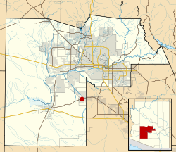
283:Sonoran Valley is located at
247:
377:Arnold, Elias (2008-08-20).
352:Arnold, Elias (2009-04-22).
321:www.womensheritagetrail.org
582:
546:
182:Lufthansa Flight Training
61:
46:
38:
31:
548:This list is incomplete.
285:geographical coordinates
494:Desert Edge High School
231:Oxford Aviation Academy
216:Oxford Aviation Academy
499:Millennium High School
381:. The Arizona Republic
234:
219:
200:is 1AZ0, and features
152:, also referred to as
81:33.05528°N 112.27111°W
53:Location of Mobile in
33:Goodyear Planning Area
225:
210:
358:The Arizona Republic
86:33.05528; -112.27111
227:Piper PA-28 Warrior
212:Piper PA-28 Warrior
77: /
235:
220:
186:All Nippon Airways
39:Nickname(s):
553:
552:
538:Goodyear Ballpark
521:
520:
427:Goodyear, Arizona
272:planned community
244:African-Americans
198:ICAO airport code
147:
146:
573:
459:
420:
413:
406:
397:
390:
389:
387:
386:
374:
368:
367:
365:
364:
349:
343:
342:
335:
329:
328:
323:. Archived from
313:
249:
170:Phoenix, Arizona
92:
91:
89:
88:
87:
82:
78:
75:
74:
73:
70:
51:
22:
581:
580:
576:
575:
574:
572:
571:
570:
556:
555:
554:
549:
542:
517:
450:
429:
424:
394:
393:
384:
382:
376:
375:
371:
362:
360:
351:
350:
346:
337:
336:
332:
315:
314:
310:
305:
297:State Route 238
293:
281:
252:Mobile, Alabama
240:
192:being based in
162:Maricopa County
85:
83:
79:
76:
71:
68:
66:
64:
63:
57:
55:Maricopa County
42:
41:Mobile, Arizona
34:
27:
20:
17:
12:
11:
5:
579:
577:
569:
568:
558:
557:
551:
550:
547:
544:
543:
541:
540:
535:
529:
527:
523:
522:
519:
518:
516:
515:
514:
513:
503:
502:
501:
496:
486:
481:
476:
471:
465:
463:
456:
452:
451:
449:
448:
443:
437:
435:
431:
430:
425:
423:
422:
415:
408:
400:
392:
391:
369:
344:
330:
327:on 2008-08-20.
307:
306:
304:
301:
292:
291:Transportation
289:
280:
277:
239:
236:
150:Sonoran Valley
145:
144:
141:Mountain (MST)
134:
128:
127:
122:
116:
115:
110:
104:
103:
100:
94:
93:
59:
58:
52:
44:
43:
40:
36:
35:
32:
29:
28:
25:
18:
15:
13:
10:
9:
6:
4:
3:
2:
578:
567:
564:
563:
561:
545:
539:
536:
534:
531:
530:
528:
524:
512:
509:
508:
507:
504:
500:
497:
495:
492:
491:
490:
487:
485:
482:
480:
477:
475:
472:
470:
467:
466:
464:
460:
457:
453:
447:
444:
442:
439:
438:
436:
434:Neighborhoods
432:
428:
421:
416:
414:
409:
407:
402:
401:
398:
380:
373:
370:
359:
355:
348:
345:
340:
334:
331:
326:
322:
318:
312:
309:
302:
300:
298:
290:
288:
286:
278:
276:
273:
268:
266:
265:running water
262:
257:
253:
245:
237:
232:
228:
224:
217:
213:
209:
205:
204:on runway 9.
203:
199:
195:
191:
187:
183:
179:
175:
171:
167:
163:
159:
155:
151:
142:
138:
135:
133:
126:
123:
121:
114:
111:
109:
102:United States
101:
99:
90:
62:Coordinates:
56:
50:
30:
23:
445:
383:. Retrieved
372:
361:. Retrieved
347:
333:
325:the original
320:
311:
294:
282:
269:
261:homesteaders
241:
153:
149:
148:
84: /
72:112°16′16″W
385:2009-06-08
363:2009-06-08
303:References
526:Landmarks
279:Geography
178:Lufthansa
174:landfills
132:Time zone
69:33°3′19″N
560:Category
441:Estrella
256:railroad
194:Goodyear
158:Goodyear
125:Maricopa
455:Schools
238:History
166:Arizona
113:Arizona
98:Country
462:Public
446:Mobile
196:. Its
154:Mobile
120:County
137:UTC-7
108:State
188:and
229:of
214:of
202:ILS
190:KLM
562::
356:.
319:.
299:.
248:c.
184:,
176:.
164:,
160:,
419:e
412:t
405:v
388:.
366:.
341:.
143:)
139:(
Text is available under the Creative Commons Attribution-ShareAlike License. Additional terms may apply.