828:
lasted into the 1980s. However the increased number of fishing boats caused stocks of groper, cod, and rock lobster off the coast of North Otago to be seriously decline. The government reintroduced controls in 1979 and imposed a moratorium on the issue of new licences. To manage fish stocks the
Fisheries Amendment Act (1986) introduced the Quota Management System (QMS), which imposes catch limits, and regulates fishing methods, areas, and timing of those activities. At the time when the QMS was introduced there were over 30 local fishermen operating small day boats out of Moeraki Harbour, with their catch being processed locally. However, in response to the QMS the major fishing companies began purchasing as much quota as they could. Poor catches of rock lobster in the 1990s impacted on the financial viability of many Moeraki based owner-operators, who sold off their quota to fund their other fishing activities and maintain their boats. Many sold their quota of rock lobster to Ngai Tahu Fisheries which processed its catch in Dunedin, thus reducing seafood processing employment opportunities at Moeraki.
674:
iron piles, which were prefabricated in
England. It was found that the piles could not be persuaded to screw into the sea bed, which meant it was necessary to hammer them in. Dogged by construction difficulties, accidents and poor weather it took over a year to construct the wharf. Upon its completion in 1873 it was found that it was too high for use by smaller vessels, which were forced to use the existing wharf. Even so, the port was busy with materials being imported to construct the new branch railway line. In 1875 as part of the preparations to abolish the Provincial Council Moeraki was allowed to have establish its own harbour board. This made the port more popular but at the same time the increased traffic reduced the road to the port to an almost impassable state. In 1874 the cutter
729:
bays were popular with swimmers they were also a favourite haunt of sharks. Following one fatal shark attack and the rescue by three men of a woman whose dinghy had overturned it was decided to build some seawater baths. The government gave approval for funds left by the now defunct
Harbour Board to be used to pay for the facility. The baths were constructed between the wharf and railway by enclosing a shallow part of the bay and opened on 28 December 1888. A crowd of 3,000 attended the opening. However over time their popularity declined which lead to the abandonment of the facility after its walls were breached by waves in 1912./> Local children continued to use remaining parts of the facility up until the 1930s.
853:
to Katiki Point. The geology is sandstone / mudstone and volcanic material. The peninsula with the exception of two small areas of indigenous bush is mostly covered in pasture or scattered scrub. The village of
Moeraki is located along the sheltered northern bays with a small fishing port with wharf and slipway structures located at its eastern end in the lee of Moeraki Point. On the eastern facing side of the peninsula there are two small kaiks (crib style settlements) in the north facing bays adjacent to Tikoraki Point (accessed via Te Kirata Rd) and Tawhiroko Point respectively (accessed via Kaika Rd and known as the Kaika). Just north of Tikoraki Point is the small half-hectare island of Maukiekie.
718:
constructed along the seashore in order to connect with its terminus station which was built near the wharf. However, from the time it opened slips were a constant problem. In 1878 a number of the piles were carried 4 ft (1.2 m) away from their position by land movement. Improvements to the port facilities at Oamaru, which saw it taking more trade coupled with the cost of constant maintenance and unreliability of the branch line led to it being closed and the rails removed in
October 1879. From that date onwards Moeraki was served by a railway station in the form of a covered goods shed at Hillgrove on the Main South Railway Line.
670:
long-awaited wharf. Bad weather delayed its completion until the following year. Unfortunately, it was soon apparent that could only 6 feet (1.8 m) of water at low tide which was too shallow for large ships. In the same year that the wharf was completed moorings suitable for 600 to 700 tons ships were laid out in the bay at the seven-fathom mark. While
Moeraki had the best natural harbour in North Otago with its inner roadstead partly protected by a bluff, by 1869 the existing wharf was in poor condition and as it didn't extend far enough out to sea there were restrictions on the size of ships that could use it.
631:
away to avoid the persecution. Whaling ceased around 1847, although there was later a brief revival. Even so, some of the whalers stayed, making their living from fishing, and farming small plots of land. In 1844 it was reported that there were 17 Europeans were living at
Moeraki, 11 living with Māori women and between them 13 children. While the whalers had trouble with raising pigs, to supplement their diet they had more luck with goats which they keep penned up on Maukiekie Island (which since then has been known locally as Goat Island). The island was also nesting place for
650:’s New Edinburgh settlement. While the area had much to recommend, he considered that while its bay was a suitable anchorage for small draught coastal vessels it would not be suitable for the deeper draught of immigrant vessels. He continued his southwards journey and eventually selected Otago Harbour as being better suited for the settlement. As the rewards from whaling declined by 1848 the number of Europeans had dropped to at least 13, but among them was a Mrs Skidmore, who is believed to have been the first woman to reside in North Otago.
1041:
Island. By the turn of the twentieth century most of the worshippers were living in
Moeraki village which eventually resulted the church being relocated in 1961 from the Kaawa Cemetery Maori Reserve and rebuilt on the waterfront at the west end of Moeraki's Centennial Park. However within seven years it was discovered that the ground was too unstable for the building and it was moved again to its present site further west at a former quarry on Haven St. The church was granted Heritage New Zealand historic place category 1 status in 2010.
555:, which was commanded by Captain Samuel Fowler. According to the Creed manuscript, discovered in 2003, they camped for the night by their boat at 'the Bluff eight miles from Moeraki to the north. However they were observed and attacked by Māori. Two of the sealers escaped and fled to Bobby's Head and Goodwood, south of Moeraki, taking two days to get there and where they were later killed and eaten. They will have passed Moeraki going north and fleeing south.
153:
1062:
households representing 300 to 400 litres per day. The water supply is drawn from the Big Kuri stream near
Hampden. Properties in Moeraki used septic tanks to dispose of their wastewater until a reticulated sewerage system and treatment plant was opened in September 1999. The treated effluent is discharged into a stream which subsequently enters the bay at a point near the Moeraki Boulders.
33:
869:
members of the community members and the WDC that completed rebuilding of the road in June 2015. By 2016 the road started to settle which the WDC assets manager claimed was due to the road being sealed "too early" and that the council would monitor it for two years as a gravel road. By 2020 the surface of Haven Street opposite
Millers Bay was so uneven that it was closed to heavy vehicles.
564:
768:(NMA) established a fish processing and packing plant at Moeraki and guaranteed to take the entire catch of the fishing boats which supplied it. Previously, fishers at the port had difficulties disposing of their catch as slow transit times by rail often resulted in the fish being spoilt before it reached the market in Christchurch.
1037:
important site ecologically and the offshore reefs are also of ecological significance. The Moeraki Promotions (Recreation & Heritage) Group (MAPG) collaborates with Tourism Waitaki and Tourism Dunedin to attract visitors to the district. MAPG established a heritage trail at Moeraki in 1993 and another at Herbert in 1999.
957:. There were 63 households, comprising 51 males and 57 females, giving a sex ratio of 0.89 males per female. The median age was 62.5 years (compared with 37.4 years nationally), with 6 people (5.6%) aged under 15 years, 6 (5.6%) aged 15 to 29, 51 (47.2%) aged 30 to 64, and 45 (41.7%) aged 65 or older.
839:
consolidated its fish processing activities at Dunedin in the 1980s Skeggs took over their facility. Following the closing of this processing facility (which was subsequently occupied by Fleurs Restaurant) commercial fisherman used a holding tank to house live rock lobster and a freezer for wet fish
717:
Work was meanwhile continuing on the branch line from Hillgrove to Moeraki which was opened on 15 February 1877. It had been expensive to construct as it required a number of cuttings to be made and two viaducts (one 1,200 ft (370 m) long and the other 1,400 ft (430 m) long) to be
618:
In their first season, which began in March 1837 the whalers caught 22 whales, receiving £8 to £10 a tun for the oil and £50 to 56 a ton for bone, with a single whale depending on size yielding 5 to 11 tuns of oil. In 1838 the station building burnt down, along with their provisions, but they caught
587:
out of Newburyport under the command of Captain Peas. After catching a large number of whales in the waters around Banks Peninsula the two ships and sailed south, calling in at the Otago whaling station. Inspired by the money being made by the Wellers and the Americans Hughes had decided to establish
856:
The Moeraki area has a long and extensive history of land instability which poses a high risk of damage to structures. This is caused by large, slowly creeping landslips in the underlying mudstone. Parts of the town occupy a landslip complex, known as the Tenby St Landslip, which is about 900 m
728:
Despite the failure to establish a direct railway service the village's scenery and sheltered outlook lead to it by the 1890s becoming a favourite destination for picnic parties from Oamaru which travelled by rail to Hillgrove from where they travelled by road to Moeraki. While the area's sheltered
721:
Following the closing of the branch railway access to what was the best anchorage in North Otago became dependent on the road, which was prone to slips and thus difficult to maintain in good condition. The restricted access together with the establishment of better facilities at Oamaru lead to trade
852:
The Moeraki Peninsula features a coastline of small sandy beaches and rocky headlands with reefs and stacks which extends from the southern end of Moeraki Beach, to the northern end of Katiki Beach. On the northern side is a coastal cliff reducing in height and steepness as it progresses southwards
741:
Moeraki became the leading fishing port of North Otago during the 1890s with its fleet growing from five vessels in 1892 to 38 in 1898, while the number of fishermen increased from 13 to 72 over the same period with the majority of the population dependent on the fishing industry to some extent for
685:
While the port was busy exporting stone and grain the £3,000 that the harbour board had been endowed with when it was created proved insufficient to pay for the necessary expansion of the port's facilities. This put it at a disadvantage compared with the better financially endowed Port Chalmers and
653:
Hughes and Haberfield, stayed, taking up land grants in the surrounding district in 1853. Following the Otago Association's settlement based at Dunedin further south in 1848 a Moeraki sheep run was being leased by 1852. A 'Hundred' was declared in 1860, opening the area to closer rural settlement.
1040:
In 1862 the Kotahitanga church (whose name means "one people”), was constructed of black pine at the Kaika for the local Ngāi Tahu who had taken up the Wesleyan faith, though the church was built with support from the Anglican mission. It is the oldest surviving Maori mission building in the South
868:
In 2013 a 350m to 400 metre long section of Haven Street collapsed following heavy rain which lead to the road having to be closed. At a meeting at the Moeraki marae with the Waitaki District Council (WDC) in 2014 the community offered to work to reopen road. This led to a partnership between the
750:
which had been originally built by Logan Bros., of Auckland, for the Union Oil Engine Company, was powered by a 25 horse-power oil engine, with a speed of 8 knots and a holding capacity for 16 tons of fish. The vessel was largely employed to tow Moeraki fishing boats to and from the reefs or other
630:
By their third season the number of whalers had increased to 32 with five boats in use with a number of Māori being employed at the station. Despite this increased number of boats the catch decreased slightly and then in 1841 rapidly dropped to nine, then two the following year as the whales moved
986:
Of those at least 15 years old, 12 (11.8%) people had a bachelor's or higher degree, and 27 (26.5%) people had no formal qualifications. The median income was $ 33,100, compared with $ 31,800 nationally. 12 people (11.8%) earned over $ 70,000 compared to 17.2% nationally. The employment status of
780:
During the era following the end of the Second World War government regulations required all fishing boats to land their catches at their port of registration even if they had to bypass processing facilities at other ports on their return from a fishing ground. There were also restrictions on the
732:
As inter-marriage took place, the Māori women moved to join their Pākehā husbands in Onekakara which by now was being called Moeraki. Around the turn of the century, more Māori families began to move into Moeraki from the two kaiks. The original marae followed from Kaika to its hill-top site some
673:
To resolve these issues work commenced in 1872 on what was estimated would be a £3,000 project to construct a larger wharf to service the increased trade now passing through the port. It was designed by the provincial engineer George Barr and instead of the traditional wooden piling used screw-in
1077:
A public school was opened in the village in 1890 with a roll of 29 pupils which had grown to 65 by 1905. By 1954, the school had between 20 and 30 pupils. In 1988 the school was closed due to a falling roll. Today the closest primary school is the Hampden Primary School in Hampden and for their
860:
Heavy rainfall has regularly led to ground movements which have damaged houses and properties in the area. In response to a heavy rainfall event in May 2010 which resulted in land movement and 28 insurance claims on Haven Street the Earthquake Commission in August of that same year installed 250
843:
By 2000 there were only six fishing boats operating out of Moeraki. By 2020 traditional commercial fishing activity had virtually been eliminated at the port with only two fishing boats, one of which was supplying Fleurs Restaurant. This dramatic decline in the number of commercial fishing boats
827:
During the deregulation of the New Zealand fishing industry between 1966 and 1979, all fisheries became open access, and anyone could harvest fish. This resulted in a doubling of the number of fishing boats based at Moeraki and prosperous times profits from rock lobster for the community, which
1036:
Moeraki Peninsula is a breeding area for yellow-eyed penguin, little blue penguin, Stewart Island shag, little shag, spotted shag, royal spoonbill and NZ fur seal. It is a haul out site for sea lion, elephant seal and leopard seal and is visited by various other species. Maukiekie Island is an
1003:
Prior to 1989 Moeraki was under the jurisdiction of the Waitaki County Council. In that year Waitaki County Council amalgamated with the Oamaru Borough Council to form the Waitaki District Council (WDC) which is based in Oamaru. The citizens of Moeraki and nearby Hampden are represented by the
864:
A hazard map published in May 2012 identified that houses in Haven St, (between Davids and Glamorgan Streets), were located on a large landslip complex and designated 268 sections as being in a “high-risk natural hazard zone”, and a further 24 sections as being in a “very high risk” zone. As a
1061:
A public water supply was established in the district during the early 1960s with the assistance of voluntary labour and services properties in Moeraki and in Hampton. It operates on a points scheme; with a point for households being the equivalent of 200 litres per day, and a point for rural
669:
In 1863 a 2.8 kilometres (1.7 mi) long unmetalled road was constructed by a crew of 40 men from the Onekakara Inn to connect the settlement with the main trunk road. With Moeraki becoming by the 1860s the key port for the shipping of Oamaru stone work commenced in the winter of 1863 on a
754:
Many residents grew vegetables and kept at least one cow. Most farming was on a small scale with those farmers that had milk surplus to their own domestic uses sending it to three nearby creameries, and in later years to the Taieri and Peninsula Milk Production plants at Oamaru and Dunedin.
771:
The settlement celebrated its centenary on 26 December 1936, but the actual public celebrations were postponed by a year until December 1937 due to an outbreak or infantile paralysis. As part of the celebrations the Centennial Park was developed on the Moeraki waterfront.
713:
in the 1870s saw increased patronage of the port at Moeraki as construction material was bought by ship and landed as close to the construction works as possible. On 4 November 1874 the section of line between Oamaru and Hillgrove (Moeraki Junction) was opened.
611:
Within two days they had offloaded all of their equipment and supplies. Over the next three months the party established a whaling station where they had landed at Onekakara, on the northern side of the peninsula, the site of the present village of Moeraki.
602:
Accompanied by his partners Peter Chevatt (often written as Chevat, Charbett, Chisnal, Chesval, Sivatt or Shavett) and John Thompson as well as by Richard Burn, William Issac Haberfield, John Knox and six unnamed Māori he disembarked from the 148 ton barque
820:
In the late 1960s the Dunedin-based Skeggs Foods Ltd opened up a new fish processing and packing shed on the seaward side of the iron wharf in completion to the NMA (which subsequently became Wrightson NMA) existing fishing processing and packing facility.
877:
Moeraki is described as a rural settlement by Statistics New Zealand, and covers 8.53 km (3.29 sq mi). It had an estimated population of 120 as of June 2023, with a population density of 14 people per km. It is part of the larger
745:
In 1895 Weir and Hull established a fish processing and packing plant which in combination with the development of faster train service, allowed fish to be sent to the Oamaru and Dunedin markets. The company purchased the diesel-powered launch
816:
In return for exclusive fuelling rights the Shell Oil Company financially assisted with the construction in the inner harbour of a fishing wharf in 1961. This was strengthened, widened and redecked in 1978 at a cost of $ 10,000.
1068:
The village is accessed by a 2.5 km sealed road from its junction with State Highway 1. While there is no public bus service direct to the village passengers can connect with passing buses at the State Highway junction.
627:. Following permission from Paitu, the rangatira of the Moeraki area, they established a permanent settlement about 3 km from what is now Moeraki township at Tawhiroko Point. Subsequently, it became known as the Kaika.
607:
on Boxing Day, 26 December 1836. All were experienced whalers. The Maori members of the party were not only experienced seamen and, hard workers, but they also a protection against any trouble with the Maoris in the locality.
781:
engine size of vessels. Boats operating from Moeraki were restricted to 50 hp engines, for instance, while vessels based at Oamaru were permitted engines up to 75 hp, and those at Port Chalmers up to 200 hp.
665:
In about 1854 H.C. Hertslet established a landing service using Māori boatmen at Moeraki and later constructed a goods shed which started a period of rivalry with the port at Oamaru as to which should service North Otago.
1743:
812:
Following the tar-sealing of the gravel access road in the early 1960s, there was an influx of newcomers and several boarding houses opened in the village - to accommodate weekend visitors from Dunedin.
1690:. Coastal Environment of Otago Natural Character and Outstanding Natural Features and Landscapes Assessment: Waitaki District Section Report (Report). Dunedin: Otago Regional Council. pp. 31, 32
662:
Moeraki remained an isolated community making a living from fishing and small scale farming until increasing demand from the development of Dunedin led to the growing of crops on a commercial basis.
473:' in modern standard Māori) the last two arrivals before the European. It is safe to say Waimatatai is a 'Waitaha' site in that broad sense but there are no specific families it can be linked to.
518:
It used to be said Moeraki, like many other places on the east coast, was not a site of permanent occupation in pre-European times, but a major study, published in 1996, shows that is unlikely.
588:
his own whaling station. He purchased two boats and all of the equipment needed to catch and process whales from the Americans he recruited others to join him from Weller brothers’ workforce.
761:
By the 1930s the fleet at Moeraki had fallen slightly to 34 vessels with groper and blue cod the main species being harvested. Jack Edmonston constructed a large fish smokehouse in the 1930s.
787:
As a number of Māori families had not returned to Moeraki after the war; the focus on the marae diminished; with its use limited to more formal occasions such as tangi and tribal meetings.
758:
Government regulations hindered residents from further developing their agricultural activities as they were not permitted to sell eggs or milk when their livestock was unregistered.
857:(3,000 ft) wide and extends 600 m (2,000 ft) back from the coast. Slips impacted on the reliability of the branch railway line and also the access road to the town.
480:(fortified settlement) of the Classic period of Māori culture. Its traditional name was Te Raka-a-hineatua. Jill Hamel has reported that it was the best developed of any southern
571:
Born in Sydney in approximately 1794 John Hughes was an experienced whaler who had first worked in New Zealand waters in 1822. In 1834 he took up an offer of employment with the
765:
484:, with terraces, and rectangular houses with stone fireplaces. Radio carbon dating has confirmed it was occupied in the 18th century. According to tradition it was built by
844:
operating out of Moeraki and resulting low catch led to the processing companies deciding it was no longer economic for them to collect fish and rock lobster from Moeraki.
579:. After completing his contract in June or July 1836 Hughes took joined on one of two American whaling ship on their way north to Peraki on Banks Peninsula. These were the
784:
The fishing fleet based at Moeraki in the 1950s and early 1960s predominantly harvested groper, although other species such as blue cod and rock lobster were also caught.
689:
To improve the safety of coastal shipping following several accidents on the dangerous reefs in the surrounding area the Marine Department commenced construction of the
824:
After it began being harvested for export during the 1960s rock lobster became a valuable species, was soon providing most of the income for Moeraki-based fisherman.
1684:
615:
Since that time European occupation has been continuous. When Hughes and his men arrived there were only nine or ten Māori living in the area, under Takatahara.
693:
on the tip of Moeraki Peninsula in 1876. The light was lit for the first time in 1878. The station was automated, and the last keeper was withdrawn in 1975.
410:
and the lack of traffic as well as stability problems caused by difficult terrain led to the closure of the railway in 1879 after only two years' operation.
462:, conventionally the third iwi, or tribe, to arrive in southern New Zealand, after Kahui Tipua and Te Rapuwai. Waitaha's expedition leader was Rākaihautū.
796:
while on a voyage from London, via Panama, to Port Chalmers and Wellington with new British cars and bagged cement ran aground two miles northeast of the
2138:
599:
either on the way to Banks Peninsula or on their return down the coast they must have explored Moeraki for Hughes decided to establish his base there.
2594:
2681:
1050:
A community hall (called Coronation Hall) was built in 1911 on Haven Street. It was refurbished in 1995 with a grant from the Lotteries Commission.
725:
Eventually in 1886 the Moeraki Harbour Board was formally abolished. Thus Moeraki lost the opportunity to become the service centre of North Otago.
503:
who were successfully repulsed by Taoka in the battle known as Te Hakopa. Taoka was also in battle with chiefs further south at Huriawa (modern
1810:
1065:
The jetties, and other facilities, at the port are privately operated, and the WDC does not provide funds for their operation and maintenance.
458:
dated as 13th century, placing it in the second wave of New Zealand's early human occupation. Gavin McLean tentatively linked its occupants to
222:
2079:
1262:
543:, also known as the “War of the Shirt”, in 1814. In that year a party of eight men under Robert Brown including two other Europeans and five
152:
2676:
398:. It was once the location of a whaling station. In the 1870s, local interests believed it could become the main port for the north
804:
was dispatched to the scene and by 3.16 pm the tug had refloated the vessel which was only slightly damaged and escorted it to port.
2630:
2051:
2032:
2013:
1998:
1963:
1410:
1316:
116:
1141:
2609:
314:
256:
465:
However, as McLean notes, 'Waitaha' is also a name simply used to designate all the peoples preceding Kati Mamoe and Kai Tahu ('
170:
2584:
987:
those at least 15 was that 39 (38.2%) people were employed full-time, 27 (26.5%) were part-time, and 3 (2.9%) were unemployed.
975:
Although some people chose not to answer the census's question about religious affiliation, 36.1% had no religion, 52.8% were
722:
though Moeraki collapsing also overnight as shipments of stone and grain transferred northwards to its more accessible rival.
2131:
54:
531:) as a supplementary food, as Moeraki was one of the most common places in New Zealand where frostfish strandings occurred.
865:
result, approximately 70 of the township's 207 existing rated properties were designated as being in one of the two zones.
2635:
2614:
2604:
2625:
2460:
2104:
1928:
2562:
2091:
Northern Approaches: A History of Waitati, Waikouaiti, Palmerston, Dunback, Moeraki, Hampden and Surrounding Districts
976:
319:
97:
1485:
476:
The Moeraki peninsula terminates to the south in Kartigi Point (“Katiki” in modern standard Māori) where there was a
69:
1095:
1058:
The Waitaki District Council (WDC) is responsible for the water supply and the sewage treatment scheme at Moeraki.
797:
459:
2510:
2504:
2124:
1656:
429:. There are other places with the same name or versions of it, all along the path from the Polynesian homeland,
2619:
2552:
2215:
548:
283:
76:
50:
1911:
2405:
2233:
1715:
1205:
1187:
1169:
954:
950:
946:
840:
from which the catches were collected and transported by truck to Dunedin or Oamaru for further processing.
690:
43:
2400:
508:
2568:
2526:
2395:
1209:
1191:
1173:
1078:
secondary education children attend either the East Otago Area School in Palmerston or schools in Oamaru.
1004:
Waihemo 14 Community Board and elect representatives of the Waihemo ward to the Waitaki District Council.
489:
293:
210:
488:, a well-known fighting chief of the late 17th to early 18th centuries, who also built fortresses at the
83:
2410:
2360:
2203:
2160:
1206:"Subnational population estimates (urban rural), by age and sex, at 30 June 1996-2023 (2023 boundaries)"
1865:
1795:
646:) inspected Moeraki and the surrounding district as part of his survey to identify a location for the
2365:
2318:
2283:
2273:
1117:, Central Otago, moved to Moeraki in the late 1990s and opened her distinctive waterside restaurant "
969:
1188:"Subnational population estimates (TA, SA2), by age and sex, at 30 June 1996-2023 (2023 boundaries)"
1170:"Subnational population estimates (RC, SA2), by age and sex, at 30 June 1996-2023 (2023 boundaries)"
65:
2482:
2339:
2288:
2110:
1772:
1405:. Christchurch: Cadsonbury Publications. pp. 5–11, 94, 95, 100, 101, 102, 165, 170, 171, 183.
1332:
647:
528:
1357:
2531:
1630:
1533:
1114:
836:
624:
1604:
1507:
1456:
861:
metres 250 m (820 ft) of drainage pipe to relieve the build-up of underground water.
2652:
2640:
2470:
2268:
2075:
2047:
2028:
2009:
1994:
1986:
1959:
1832:
1406:
1312:
1258:
980:
832:
791:
639:
2557:
2488:
2147:
1268:
1118:
1087:
632:
414:
406:, was built to the settlement and opened in 1877. However, the port could not compete with
332:
301:
227:
485:
481:
477:
2589:
2476:
1106:
710:
702:
572:
455:
1578:
1432:
1091:
995:
The local economy is dependent upon farming, small scale commercial fishing and tourism.
965:
540:
451:
447:
2521:
2420:
706:
466:
403:
1358:"Two Romantic Pioneers: Hughes and Haberfield Important Names in Settlement's History"
1333:"Two Romantic Pioneers: Hughes and Haberfield Important Names in Settlement's History"
742:
their livelihood. The first fishing vessels were rowboats and sail-assisted dinghies.
2670:
2599:
2516:
2185:
90:
2111:
Two Romantic Pioneers: Hughes and Haberfield Important Names in Settlement's History
1889:
709:
line to connect Moeraki to it. The building of the Oamaru to Dunedin section of the
2536:
2465:
2455:
2221:
2197:
2191:
1913:
The Cyclopedia of New Zealand - Otago & Southland Provincial Districts: Moeraki
1231:
512:
391:
327:
306:
261:
1311:. Dunedin, NZ: Otago Heritage Books. pp. 14, 15, 18, 21, 30, 38, 39, 79, 84.
1019:
961:
620:
470:
379:
2425:
2385:
2370:
2227:
2151:
2116:
2063:
The History of Oamaru and North Otago, New Zealand: From 1853 to the end of 1889
500:
395:
32:
1101:
1104:
lived in Moeraki in the 1980s while she wrote her Booker Prize–winning novel
185:
172:
17:
2415:
2245:
1272:
2375:
1047:
The Moeraki Yachting and Boating Club has a clubhouse near the boat ramp.
2435:
2313:
2293:
1990:
1024:
504:
751:
fishing grounds, as well as trawling the coast or fishing at the reefs.
563:
2430:
2380:
2355:
2308:
2303:
2298:
2278:
2262:
2239:
1255:
Secrets of the Sea: The Story of New Zealand's Native Sea Creatures
899:
879:
430:
1586:, Taylor Baines & Associates, pp. 2, 3, 6, 10, 11, 13, 14, 16
2334:
2164:
1113:
Fleur Sullivan, the founder of the well-known Oliver's restaurant in
576:
544:
493:
407:
1983:
Shag River Mouth: the archaeology of an early southern Maori village
2656:
2209:
1014:
399:
215:
1916:(Hardback). Christchurch: Cyclopedia Company. 1905. p. 454.
1657:"On the waterfront: Ship grounds off Moeraki on Anzac Day, 1952"
619:
27 whales. In that same year a large heke (migration party) of
2120:
2113:. Reminiscences of whaler and early settler William Haberfield.
2093:(Hardback). Dunedin: Otago Centennial Historical Publications.
374:
26:
1022:
and its Te Rūnanga o Moeraki branch, and includes the Uenuku
1846:
894:
1985:, Canberra, Australia: The Australian National University.
1981:
Anderson, A., Allingham, B., & Smith, I. W. G. (1996).
1094:. A number of those works are now in the collection of the
499:
Shortly after it was built it was attacked by a party from
1824:
1403:
History of North Otago: For Centennial Period 1840 to 1940
583:
out of Newport, Rhode Island under Captain Potter and the
551:
looking for a group of lascars who had absconded from the
1164:
1162:
682:
ran onto the rocks at Moeraki, but with no loss of life.
701:
In the early 1870s with construction commencing on the
1539:. New Zealand House of Representatives. 20 July 1886
1121:" in the remains of an old whaling station in 2002.
972:. People may identify with more than one ethnicity.
390:
is a small fishing village on the east coast of the
2577:
2545:
2497:
2448:
2348:
2327:
2255:
2178:
2171:
1457:"Oamaru and Moeraki Railway. Mr. Paterson's Report"
766:
National Mortgage and Agency Company of New Zealand
372:
364:
356:
351:
343:
338:
325:
312:
299:
289:
276:
271:
249:
241:
233:
221:
209:
201:
136:
57:. Unsourced material may be challenged and removed.
1958:(Paperback). Dunedin, NZ: Otago University Press.
1257:. HarperCollins Publishers Ltd. pp. 214–217.
1044:Moeraki also has a Seventh Day Adventist chapel.
953:, and a decrease of 24 people (−18.2%) since the
2006:Taka A Vignette Life of William Tucker 1784-1817
547:, or Indian seamen, came up the east coast from
1572:
1570:
1568:
1566:
1564:
1562:
1560:
1558:
1556:
1554:
678:became stranded at Moeraki. In 1876 the cutter
446:The south side of the Moeraki Peninsula has an
2027:. Wellington, NZ: Department of Conservation.
1813:. Statistics New Zealand. March 2020. 7027748.
1805:
1803:
2132:
1012:Moeraki Marae is located at Moeraki. It is a
8:
1811:"Statistical area 1 dataset for 2018 Census"
1749:(Report). Tonkin & Taylor. pp. 1, 2
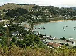
885:
2044:'Moeraki: 150 years of net and plough share
1744:Waitaki District Council Moeraki Hazard Map
1508:"Opening of the Oamaru And Moeraki Railway"
1309:'Moeraki: 150 years of net and plough share
949:, a decrease of 6 people (−5.3%) since the
790:At 2.30 am on 24 April 1952 the cargo ship
635:which were highly prized by the Ngāi Tahu.
522:
515:). Taoka's principal opponent was Te Wera.
157:View from Moeraki Esplanade Reserve in 2009
2175:
2139:
2125:
2117:
1737:
1735:
1396:
1394:
1392:
1390:
1388:
1386:
1384:
1382:
1380:
1378:
884:
133:
2595:Oamaru Steam and Rail Restoration Society
1577:Baines, James; McClintock, Wayne (2000),
1302:
1090:regularly visited Moeraki to paint local
413:The village is best known for the nearby
117:Learn how and when to remove this message
1678:
1676:
1300:
1298:
1296:
1294:
1292:
1290:
1288:
1286:
1284:
1282:
567:The bay at Moeraki showing fishing boats
562:
1766:
1764:
1709:
1707:
1705:
1130:
945:Moeraki had a population of 108 at the
521:The residents of Moeraki regularly ate
371:
350:
337:
270:
248:
200:
165:
161:
149:
2659:. Places marked ‡ are in both regions.
2089:Moore, Charles William Stuart (1958).
2070:Sorrell, Paul; Warman, Graham (2008).
1716:"Moeraki, grounds for serious concern"
1480:
1478:
1426:
1424:
1422:
1136:
1134:
2046:. Dunedin, NZ: Otago Heritage Books.
705:plans were made to construct a short
363:
355:
342:
324:
311:
298:
288:
275:
240:
232:
220:
208:
7:
1977:. Dunedin, NZ: Otago Heritage Books.
55:adding citations to reliable sources
1864:Campbell, Bill (26 December 2011),
737:Development of the fishing industry
425:'Moeraki' is usually translated as
347:8.53 km (3.29 sq mi)
2655:. All other places are within the
2008:. Dunedin, NZ: Port Daniel Press.
1796:2018 Census place summary: Waihemo
1771:MacLean, Hamish (1 October 2016),
1253:Vennell, Robert (5 October 2022).
559:Establishment of a whaling station
454:site at Waimataitai lagoon, which
25:
2631:Waitaki District Council building
1431:Burgess, Linda (29 August 2015),
623:Māori from Kaiapoi arrived under
539:Moeraki was traversed during the
2105:Waitaki District Coastal Hazards
1975:When All the Moa-Ovens Grew Cold
960:Ethnicities were 88.9% European/
151:
31:
2682:Whaling stations in New Zealand
2651:Places marked * are within the
2585:North Otago Cricket Association
1714:Ashton, Andrew (11 June 2013),
42:needs additional citations for
1929:"Moeraki will rock your world"
1655:Wright, Doug (23 April 2012),
983:and 2.8% had other religions.
800:. The Port Chalmers-based tug
507:Peninsula), Mapoutahi (modern
1:
1927:Carlson, Liz (23 June 2018).
402:area and a railway line, the
290: • Regional council
131:Village in Otago, New Zealand
2065:. Oamaru, NZ: Andrew Fraser.
1866:"Settlement marks 175 years"
1773:"The do-it-yourself village"
1683:Moore, Mike (25 June 2015).
2563:Canterbury Regional Council
1853:. Te Potiki National Trust.
1825:"Te Kāhui Māngai directory"
1534:"Supplementary Order Paper"
1514:. Dunedin. 11 November 1874
1203:(territorial authorities);
733:time in the 1920s and 30s.
638:Between 18 and 20 May 1844
2698:
2636:Waitaki Girls' High School
2615:St Joseph's School, Oamaru
2498:Facilities and attractions
1611:. Auckland. 6 January 1902
1096:Dunedin Public Art Gallery
2677:Populated places in Otago
2649:
2626:Waitaki Boys' High School
2511:Alps to Ocean Cycle Trail
2505:Ahuriri Conservation Park
2158:
2074:. Auckland, NZ: Penguin.
1742:Halliday, Graeme (2012).
1463:. Oamaru. 24 January 1868
938:
912:—
591:During the voyage of the
166:
162:
150:
143:
2620:Takiroa Rock Art Shelter
2025:The Archaeology of Otago
1956:The Welcome of Strangers
1401:McDonald, K. C. (1998).
1142:"ArcGIS Web Application"
880:Waihemo statistical area
549:Stewart Island / Rakiura
535:Arrival of the Europeans
284:Waitaki District Council
2061:Robert, W.H.S. (1890).
1580:A Case Study of Moeraki
1146:statsnz.maps.arcgis.com
981:Māori religious beliefs
947:2018 New Zealand census
798:Kātiki Point Lighthouse
711:Main South Railway Line
703:Main South Railway Line
691:Katiki Point Lighthouse
686:Oamaru harbour boards.
658:Development of the port
642:(having arrived on the
511:) and Pukekura (modern
427:a place to sleep by day
2569:Otago Regional Council
2527:Oamaru locomotive dump
2042:McLean, Gavin (1986).
1892:. Heritage New Zealand
1488:. Maritime New Zealand
1307:McLean, Gavin (1986).
1210:Statistics New Zealand
1192:Statistics New Zealand
1174:Statistics New Zealand
568:
523:
294:Otago Regional Council
2610:St Patrick's Basilica
2411:Shag Point / Matakaea
2004:Entwisle, P. (2005).
1973:Anderson, A. (1983).
1954:Anderson, A. (1998).
1185:(regional councils);
1032:Attractions/Amenities
886:Historical population
577:Otago whaling station
566:
509:Goat Island Peninsula
368:14/km (36/sq mi)
279:Territorial authority
223:Territorial authority
1890:"Kotahitanga Church"
1018:(meeting ground) of
365: • Density
51:improve this article
2483:Omarama Clay Cliffs
2449:Geographic features
1631:"Moeraki Centenary"
887:
648:New Zealand Company
182: /
2605:St Kevin's College
2532:Oamaru Opera House
2023:Hamel, J. (2001).
1637:, 23 December 1937
1609:New Zealand Herald
1339:, 14 February 1891
1086:In the late 1890s
837:Fletcher Challenge
835:’s parent company
625:Matiaha Tiramorehu
569:
357: • Total
344: • Total
186:45.362°S 170.841°E
2664:
2663:
2653:Canterbury Region
2641:Whitestone Cheese
2471:Kokoamu Greensand
2444:
2443:
2081:978-01-4300-860-6
1870:Otago Daily Times
1777:Otago Daily Times
1720:Otago Daily Times
1661:Otago Daily Times
1461:North Otago Times
1437:Otago Daily Times
1364:, 4 December 1937
1264:978-1-77554-179-0
943:
942:
640:Frederick Tuckett
385:
384:
245:Waihemo Community
127:
126:
119:
101:
16:(Redirected from
2689:
2553:District Council
2176:
2172:Populated places
2148:Waitaki District
2141:
2134:
2127:
2118:
2094:
2085:
2066:
2057:
2038:
2019:
1978:
1969:
1941:
1940:
1938:
1936:
1924:
1918:
1917:
1908:
1902:
1901:
1899:
1897:
1886:
1880:
1879:
1878:
1876:
1861:
1855:
1854:
1843:
1837:
1836:
1821:
1815:
1814:
1807:
1798:
1793:
1787:
1786:
1785:
1783:
1768:
1759:
1758:
1756:
1754:
1748:
1739:
1730:
1729:
1728:
1726:
1711:
1700:
1699:
1697:
1695:
1689:
1680:
1671:
1670:
1669:
1667:
1652:
1646:
1645:
1644:
1642:
1627:
1621:
1620:
1618:
1616:
1601:
1595:
1594:
1593:
1591:
1585:
1574:
1549:
1548:
1546:
1544:
1538:
1530:
1524:
1523:
1521:
1519:
1504:
1498:
1497:
1495:
1493:
1482:
1473:
1472:
1470:
1468:
1453:
1447:
1446:
1445:
1443:
1433:"A rich history"
1428:
1417:
1416:
1398:
1373:
1372:
1371:
1369:
1354:
1348:
1347:
1346:
1344:
1329:
1323:
1322:
1304:
1277:
1276:
1250:
1244:
1243:
1241:
1239:
1228:
1222:
1220:
1218:
1216:
1202:
1200:
1198:
1184:
1182:
1180:
1166:
1157:
1156:
1154:
1152:
1138:
1088:Frances Hodgkins
901:
896:
888:
526:
442:Māori settlement
415:Moeraki Boulders
302:Mayor of Waitaki
280:
228:Waitaki District
197:
196:
194:
193:
192:
191:-45.362; 170.841
187:
183:
180:
179:
178:
175:
155:
134:
122:
115:
111:
108:
102:
100:
59:
35:
27:
21:
2697:
2696:
2692:
2691:
2690:
2688:
2687:
2686:
2667:
2666:
2665:
2660:
2645:
2590:The Oamaru Mail
2573:
2541:
2493:
2477:Mackenzie Basin
2440:
2344:
2323:
2256:Corriedale Ward
2251:
2167:
2154:
2145:
2101:
2088:
2082:
2069:
2060:
2054:
2041:
2035:
2022:
2016:
2003:
1972:
1966:
1953:
1950:
1948:Further reading
1945:
1944:
1934:
1932:
1926:
1925:
1921:
1910:
1909:
1905:
1895:
1893:
1888:
1887:
1883:
1874:
1872:
1863:
1862:
1858:
1845:
1844:
1840:
1823:
1822:
1818:
1809:
1808:
1801:
1794:
1790:
1781:
1779:
1770:
1769:
1762:
1752:
1750:
1746:
1741:
1740:
1733:
1724:
1722:
1713:
1712:
1703:
1693:
1691:
1687:
1682:
1681:
1674:
1665:
1663:
1654:
1653:
1649:
1640:
1638:
1629:
1628:
1624:
1614:
1612:
1603:
1602:
1598:
1589:
1587:
1583:
1576:
1575:
1552:
1542:
1540:
1536:
1532:
1531:
1527:
1517:
1515:
1506:
1505:
1501:
1491:
1489:
1484:
1483:
1476:
1466:
1464:
1455:
1454:
1450:
1441:
1439:
1430:
1429:
1420:
1413:
1400:
1399:
1376:
1367:
1365:
1356:
1355:
1351:
1342:
1340:
1331:
1330:
1326:
1319:
1306:
1305:
1280:
1265:
1252:
1251:
1247:
1237:
1235:
1234:. Lonely Planet
1230:
1229:
1225:
1214:
1212:
1204:
1196:
1194:
1186:
1178:
1176:
1168:
1167:
1160:
1150:
1148:
1140:
1139:
1132:
1127:
1107:The Bone People
1084:
1075:
1056:
1034:
1010:
1001:
993:
875:
850:
810:
778:
739:
699:
660:
573:Weller brothers
561:
537:
490:Ashburton River
456:Atholl Anderson
444:
439:
423:
328:Te Tai Tonga MP
278:
267:
190:
188:
184:
181:
176:
173:
171:
169:
168:
158:
146:
139:
132:
123:
112:
106:
103:
60:
58:
48:
36:
23:
22:
15:
12:
11:
5:
2695:
2693:
2685:
2684:
2679:
2669:
2668:
2662:
2661:
2650:
2647:
2646:
2644:
2643:
2638:
2633:
2628:
2623:
2617:
2612:
2607:
2602:
2597:
2592:
2587:
2581:
2579:
2575:
2574:
2572:
2571:
2566:
2560:
2555:
2549:
2547:
2543:
2542:
2540:
2539:
2534:
2529:
2524:
2522:Oamaru Airport
2519:
2514:
2508:
2501:
2499:
2495:
2494:
2492:
2491:
2486:
2480:
2474:
2468:
2463:
2461:Elephant Rocks
2458:
2452:
2450:
2446:
2445:
2442:
2441:
2439:
2438:
2433:
2428:
2423:
2421:Trotters Gorge
2418:
2413:
2408:
2403:
2398:
2393:
2388:
2383:
2378:
2373:
2368:
2363:
2358:
2352:
2350:
2346:
2345:
2343:
2342:
2337:
2331:
2329:
2325:
2324:
2322:
2321:
2316:
2311:
2306:
2301:
2296:
2291:
2286:
2281:
2276:
2271:
2266:
2259:
2257:
2253:
2252:
2250:
2249:
2243:
2237:
2231:
2225:
2219:
2213:
2207:
2201:
2195:
2189:
2182:
2180:
2173:
2169:
2168:
2159:
2156:
2155:
2146:
2144:
2143:
2136:
2129:
2121:
2115:
2114:
2108:
2100:
2099:External links
2097:
2096:
2095:
2086:
2080:
2067:
2058:
2052:
2039:
2033:
2020:
2014:
2001:
1979:
1970:
1964:
1949:
1946:
1943:
1942:
1919:
1903:
1881:
1856:
1838:
1833:Te Puni Kōkiri
1816:
1799:
1788:
1760:
1731:
1701:
1672:
1647:
1622:
1596:
1550:
1525:
1499:
1486:"Katiki Point"
1474:
1448:
1418:
1411:
1374:
1349:
1324:
1317:
1278:
1263:
1245:
1223:
1158:
1129:
1128:
1126:
1123:
1083:
1082:Notable people
1080:
1074:
1071:
1055:
1054:Infrastructure
1052:
1033:
1030:
1009:
1006:
1000:
997:
992:
989:
941:
940:
936:
935:
932:
929:
925:
924:
921:
918:
914:
913:
910:
907:
903:
902:
897:
892:
874:
871:
849:
846:
809:
806:
793:Viggo Hansteen
777:
774:
738:
735:
698:
695:
659:
656:
560:
557:
536:
533:
443:
440:
438:
435:
422:
419:
404:Moeraki Branch
383:
382:
377:
370:
369:
366:
362:
361:
358:
354:
353:
349:
348:
345:
341:
340:
336:
335:
330:
323:
322:
320:Miles Anderson
317:
310:
309:
304:
297:
296:
291:
287:
286:
281:
274:
273:
269:
268:
266:
265:
259:
253:
251:
247:
246:
243:
239:
238:
235:
231:
230:
225:
219:
218:
213:
207:
206:
203:
199:
198:
164:
163:
160:
159:
156:
148:
147:
144:
141:
140:
137:
130:
125:
124:
107:September 2022
39:
37:
30:
24:
14:
13:
10:
9:
6:
4:
3:
2:
2694:
2683:
2680:
2678:
2675:
2674:
2672:
2658:
2654:
2648:
2642:
2639:
2637:
2634:
2632:
2629:
2627:
2624:
2621:
2618:
2616:
2613:
2611:
2608:
2606:
2603:
2601:
2600:Radio Waitaki
2598:
2596:
2593:
2591:
2588:
2586:
2583:
2582:
2580:
2578:Organisations
2576:
2570:
2567:
2564:
2561:
2559:
2556:
2554:
2551:
2550:
2548:
2544:
2538:
2535:
2533:
2530:
2528:
2525:
2523:
2520:
2518:
2517:The Libratory
2515:
2512:
2509:
2506:
2503:
2502:
2500:
2496:
2490:
2487:
2484:
2481:
2478:
2475:
2472:
2469:
2467:
2464:
2462:
2459:
2457:
2454:
2453:
2451:
2447:
2437:
2434:
2432:
2429:
2427:
2424:
2422:
2419:
2417:
2414:
2412:
2409:
2407:
2404:
2402:
2399:
2397:
2394:
2392:
2389:
2387:
2384:
2382:
2379:
2377:
2374:
2372:
2369:
2367:
2364:
2362:
2359:
2357:
2354:
2353:
2351:
2347:
2341:
2338:
2336:
2333:
2332:
2330:
2326:
2320:
2317:
2315:
2312:
2310:
2307:
2305:
2302:
2300:
2297:
2295:
2292:
2290:
2287:
2285:
2282:
2280:
2277:
2275:
2272:
2270:
2267:
2264:
2261:
2260:
2258:
2254:
2247:
2244:
2241:
2238:
2235:
2232:
2229:
2226:
2223:
2220:
2217:
2214:
2211:
2208:
2205:
2202:
2199:
2196:
2193:
2190:
2187:
2184:
2183:
2181:
2179:Ahuriri Ward*
2177:
2174:
2170:
2166:
2162:
2157:
2153:
2149:
2142:
2137:
2135:
2130:
2128:
2123:
2122:
2119:
2112:
2109:
2106:
2103:
2102:
2098:
2092:
2087:
2083:
2077:
2073:
2072:'Fleurs Place
2068:
2064:
2059:
2055:
2053:0-9597723-3-2
2049:
2045:
2040:
2036:
2034:0-478-22016-2
2030:
2026:
2021:
2017:
2015:0-473-10098-3
2011:
2007:
2002:
2000:
1999:0-7315-0342-1
1996:
1992:
1988:
1984:
1980:
1976:
1971:
1967:
1965:1-877133-41-8
1961:
1957:
1952:
1951:
1947:
1930:
1923:
1920:
1915:
1914:
1907:
1904:
1891:
1885:
1882:
1871:
1867:
1860:
1857:
1852:
1851:maorimaps.com
1848:
1842:
1839:
1834:
1830:
1826:
1820:
1817:
1812:
1806:
1804:
1800:
1797:
1792:
1789:
1778:
1774:
1767:
1765:
1761:
1745:
1738:
1736:
1732:
1721:
1717:
1710:
1708:
1706:
1702:
1686:
1679:
1677:
1673:
1662:
1658:
1651:
1648:
1636:
1632:
1626:
1623:
1610:
1606:
1600:
1597:
1582:
1581:
1573:
1571:
1569:
1567:
1565:
1563:
1561:
1559:
1557:
1555:
1551:
1535:
1529:
1526:
1513:
1512:Otago Witness
1509:
1503:
1500:
1487:
1481:
1479:
1475:
1462:
1458:
1452:
1449:
1438:
1434:
1427:
1425:
1423:
1419:
1414:
1412:1-877151-22-X
1408:
1404:
1397:
1395:
1393:
1391:
1389:
1387:
1385:
1383:
1381:
1379:
1375:
1363:
1359:
1353:
1350:
1338:
1334:
1328:
1325:
1320:
1318:0-9597723-3-2
1314:
1310:
1303:
1301:
1299:
1297:
1295:
1293:
1291:
1289:
1287:
1285:
1283:
1279:
1274:
1270:
1266:
1260:
1256:
1249:
1246:
1233:
1227:
1224:
1221:(urban areas)
1211:
1207:
1193:
1189:
1175:
1171:
1165:
1163:
1159:
1147:
1143:
1137:
1135:
1131:
1124:
1122:
1120:
1119:Fleur's Place
1116:
1111:
1109:
1108:
1103:
1099:
1097:
1093:
1089:
1081:
1079:
1072:
1070:
1066:
1063:
1059:
1053:
1051:
1048:
1045:
1042:
1038:
1031:
1029:
1027:
1026:
1021:
1017:
1016:
1007:
1005:
998:
996:
990:
988:
984:
982:
978:
973:
971:
967:
963:
958:
956:
952:
948:
937:
933:
930:
927:
926:
922:
919:
916:
915:
911:
908:
905:
904:
898:
893:
890:
889:
883:
881:
872:
870:
866:
862:
858:
854:
847:
845:
841:
838:
834:
833:Wrightson NMA
829:
825:
822:
818:
814:
807:
805:
803:
799:
795:
794:
788:
785:
782:
775:
773:
769:
767:
762:
759:
756:
752:
749:
743:
736:
734:
730:
726:
723:
719:
715:
712:
708:
704:
696:
694:
692:
687:
683:
681:
677:
671:
667:
663:
657:
655:
651:
649:
645:
641:
636:
634:
628:
626:
622:
616:
613:
609:
606:
600:
598:
594:
589:
586:
582:
578:
574:
565:
558:
556:
554:
550:
546:
542:
534:
532:
530:
525:
519:
516:
514:
510:
506:
502:
497:
495:
491:
487:
483:
479:
474:
472:
468:
463:
461:
457:
453:
450:(moa hunter)
449:
441:
436:
434:
432:
428:
420:
418:
416:
411:
409:
405:
401:
397:
393:
389:
381:
378:
376:
367:
359:
346:
334:
333:Tākuta Ferris
331:
329:
326: •
321:
318:
316:
313: •
308:
305:
303:
300: •
295:
292:
285:
282:
277: •
263:
260:
258:
255:
254:
252:
244:
236:
229:
226:
224:
217:
214:
212:
204:
195:
167:Coordinates:
154:
142:
135:
129:
121:
118:
110:
99:
96:
92:
89:
85:
82:
78:
75:
71:
68: –
67:
63:
62:Find sources:
56:
52:
46:
45:
40:This article
38:
34:
29:
28:
19:
18:Moeraki Marae
2657:Otago Region
2537:Steampunk HQ
2466:Katiki Beach
2456:Cape Wanbrow
2390:
2349:Waihemo Ward
2222:Lake Waitaki
2198:Danseys Pass
2090:
2071:
2062:
2043:
2024:
2005:
1982:
1974:
1955:
1933:. Retrieved
1922:
1912:
1906:
1894:. Retrieved
1884:
1873:, retrieved
1869:
1859:
1850:
1847:"Māori Maps"
1841:
1828:
1819:
1791:
1780:, retrieved
1776:
1751:. Retrieved
1723:, retrieved
1719:
1692:. Retrieved
1685:"Appendix 3"
1664:, retrieved
1660:
1650:
1639:, retrieved
1635:Evening Star
1634:
1625:
1613:. Retrieved
1608:
1599:
1588:, retrieved
1579:
1541:. Retrieved
1528:
1516:. Retrieved
1511:
1502:
1490:. Retrieved
1465:. Retrieved
1460:
1451:
1440:, retrieved
1436:
1402:
1366:, retrieved
1362:Evening Star
1361:
1352:
1341:, retrieved
1337:Evening Star
1336:
1327:
1308:
1254:
1248:
1236:. Retrieved
1226:
1213:. Retrieved
1195:. Retrieved
1177:. Retrieved
1149:. Retrieved
1145:
1112:
1105:
1100:
1085:
1076:
1067:
1064:
1060:
1057:
1049:
1046:
1043:
1039:
1035:
1023:
1013:
1011:
1002:
994:
985:
974:
959:
944:
876:
873:Demographics
867:
863:
859:
855:
851:
842:
830:
826:
823:
819:
815:
811:
801:
792:
789:
786:
783:
779:
770:
764:In 1935 the
763:
760:
757:
753:
747:
744:
740:
731:
727:
724:
720:
716:
700:
688:
684:
679:
675:
672:
668:
664:
661:
652:
643:
637:
629:
617:
614:
610:
604:
601:
596:
592:
590:
584:
580:
570:
552:
541:Sealers' War
538:
520:
517:
513:Taiaroa Head
498:
475:
464:
445:
426:
424:
412:
392:South Island
387:
386:
307:Gary Kircher
262:Te Tai Tonga
237:Waihemo Ward
128:
113:
104:
94:
87:
80:
73:
61:
49:Please help
44:verification
41:
2426:Waianakarua
2371:Inch Valley
2328:Oamaru Ward
2234:Livingstone
2228:Lindis Pass
2152:New Zealand
1896:10 February
1829:tkm.govt.nz
1666:10 February
1442:10 February
1238:11 February
979:, 2.8% had
968:, and 2.8%
955:2006 census
951:2013 census
575:' at their
467:Ngāti Mamoe
396:New Zealand
250:Electorates
205:New Zealand
189: /
177:170°50′28″E
2671:Categories
2546:Government
2406:Palmerston
2269:Georgetown
1753:16 October
1725:16 October
1694:16 October
1641:25 January
1615:9 February
1605:"Shipping"
1492:16 October
1368:25 January
1343:25 January
1273:Q114871191
1215:25 October
1197:25 October
1179:25 October
1151:2 December
1125:References
1102:Keri Hulme
999:Governance
633:muttonbird
352:Population
315:Waitaki MP
272:Government
174:45°21′43″S
77:newspapers
2416:Stoneburn
2396:Morrisons
2246:Otematata
1875:7 January
1782:7 January
1543:6 January
1232:"Moeraki"
1073:Education
1020:Ngāi Tahu
977:Christian
848:Geography
621:Ngāi Tahu
529:frostfish
492:and near
471:Ngāi Tahu
380:Ngāi Tahu
242:Community
66:"Moeraki"
2489:Puketapu
2436:Wairunga
2401:Nenthorn
2386:Mākareao
2361:Glenpark
2314:Tokarahi
2294:Maruakoa
2204:Duntroon
2186:Aviemore
1991:34751263
1269:Wikidata
1025:wharenui
964:, 16.7%
939:Source:
748:Moerangi
595:and the
593:Merrimac
581:Merrimac
505:Karitane
501:Kaikōura
2431:Waihemo
2391:Moeraki
2381:Macraes
2366:Hampden
2356:Dunback
2319:Windsor
2309:Pukeuri
2304:Otepopo
2299:Ngapara
2284:Kia Ora
2279:Kakanui
2274:Herbert
2263:Bortons
2240:Omarama
2192:Benmore
1931:. Stuff
1590:17 June
1518:22 June
1467:22 June
1008:Culture
991:Economy
900:±% p.a.
802:Dunedin
697:Railway
676:Glimpse
644:Deborah
553:Matilda
545:lascars
469:' and '
460:Waitaha
448:Archaic
437:History
431:Hawaiki
388:Moeraki
264:(Māori)
257:Waitaki
202:Country
145:Village
138:Moeraki
91:scholar
2376:Kātiki
2340:Weston
2335:Oamaru
2289:Maheno
2165:Oamaru
2078:
2050:
2031:
2012:
1997:
1989:
1962:
1935:18 May
1409:
1315:
1271:
1261:
962:Pākehā
934:−1.08%
923:−2.07%
831:After
707:branch
605:Magnet
597:Martha
585:Martha
494:Timaru
408:Oamaru
373:Local
211:Region
93:
86:
79:
72:
64:
2558:Mayor
2210:Kurow
1747:(PDF)
1688:(PDF)
1584:(PDF)
1537:(PDF)
1115:Clyde
1092:Māori
1015:marae
970:Asian
966:Māori
808:1960s
776:1950s
486:Taoka
452:Māori
400:Otago
216:Otago
98:JSTOR
84:books
2216:Ōhau
2161:Seat
2076:ISBN
2048:ISBN
2029:ISBN
2010:ISBN
1995:ISBN
1987:OCLC
1960:ISBN
1937:2019
1898:2021
1877:2021
1784:2021
1755:2020
1727:2020
1696:2020
1668:2021
1643:2021
1617:2021
1592:2019
1545:2021
1520:2019
1494:2020
1469:2019
1444:2021
1407:ISBN
1370:2021
1345:2021
1313:ISBN
1259:ISBN
1240:2021
1217:2023
1199:2023
1181:2023
1153:2021
928:2018
917:2013
906:2006
895:Pop.
891:Year
680:Hope
524:pāra
421:Name
339:Area
234:Ward
70:news
931:108
920:114
909:132
496:.
394:of
375:iwi
360:120
53:by
2673::
2163::
2150:,
1993:,
1868:,
1849:.
1831:.
1827:.
1802:^
1775:,
1763:^
1734:^
1718:,
1704:^
1675:^
1659:,
1633:,
1607:.
1553:^
1510:.
1477:^
1459:.
1435:,
1421:^
1377:^
1360:,
1335:,
1281:^
1267:.
1208:.
1190:.
1172:.
1161:^
1144:.
1133:^
1110:.
1098:.
1028:.
882:.
482:pā
478:pā
433:.
417:.
2622:*
2565:*
2513:‡
2507:*
2485:*
2479:*
2473:‡
2265:*
2248:*
2242:*
2236:*
2230:‡
2224:*
2218:*
2212:*
2206:*
2200:‡
2194:*
2188:*
2140:e
2133:t
2126:v
2107:.
2084:.
2056:.
2037:.
2018:.
1968:.
1939:.
1900:.
1835:.
1757:.
1698:.
1619:.
1547:.
1522:.
1496:.
1471:.
1415:.
1321:.
1275:.
1242:.
1219:.
1201:.
1183:.
1155:.
527:(
120:)
114:(
109:)
105:(
95:·
88:·
81:·
74:·
47:.
20:)
Text is available under the Creative Commons Attribution-ShareAlike License. Additional terms may apply.