268:
210:
202:
31:
197:
of
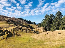
Uttarakhand, is situated at the centre of the bugyal, dedicated to the fairy goddesses known as 'Pari mata' or 'Matriya Mata' believed to be residing there according to the locals. The glorious views of the Garhwal Himalayas can be seen from here.
231:
313:
332:
306:
63:
337:
299:
193:
Budher Caves, situated at the corner of the Bugyal is also a place to visit. Also, an ancient temple built in traditional
56:
190:
trees. The trek to the Bugyal is of 3km and starts from Budher Forest Rest House, which is around 30km from
Chakrata.
194:
140:
267:
167:
136:
103:
283:
158:' translates to pasturous fields on higher peaks of the mountains, it's also known as a
187:
118:
209:
201:
326:
163:
182:
Destination. The Bugyal has the highest elevation of 2759m and is around 40km from
30:
279:
171:
107:
78:
65:
245:
183:
125:
179:
175:
159:
46:
275:
208:
200:
111:
144:
287:
117:
99:
94:
55:
45:
40:
23:
162:(Himalayan Alpine Meadows). It is situated in the
186:. Moila Danda is situated between thousands of
307:
8:
314:
300:
274:This article related to a location in the
20:
16:Alpine pasture land in Uttarakhand, India
223:
7:
264:
262:
286:. You can help Knowledge (XXG) by
14:
266:
29:
1:
51:2,699 m (8,855 ft)
333:Uttarakhand geography stubs
205:Moila Danda in late winters
354:
261:
79:30.7768200°N 77.7845050°E
28:
24:Moila Danda/ मोइला डाण्डा
195:Koti Banal architecture
214:
213:Moila Danda in Summers
206:
84:30.7768200; 77.7845050
338:Geography of Dehradun
212:
204:
246:"Moila Top Chakrata"
174:. Moila Danda is a
75: /
215:
207:
41:Highest point
295:
294:
234:. tripadvisor.in.
168:Dehradun district
131:
130:
104:Dehradun district
345:
316:
309:
302:
270:
263:
250:
249:
242:
236:
235:
232:"Moila Top Trek"
228:
143:Moila Hill-top,
139:: मोइला डाण्डा,
126:Garhwal Himalaya
121:
90:
89:
87:
86:
85:
80:
76:
73:
72:
71:
68:
33:
21:
353:
352:
348:
347:
346:
344:
343:
342:
323:
322:
321:
320:
259:
256:
254:
253:
244:
243:
239:
230:
229:
225:
220:
119:
83:
81:
77:
74:
69:
66:
64:
62:
61:
36:
17:
12:
11:
5:
351:
349:
341:
340:
335:
325:
324:
319:
318:
311:
304:
296:
293:
292:
271:
252:
251:
248:. seekpeak.in.
237:
222:
221:
219:
216:
166:region of the
151:also known as
129:
128:
123:
115:
114:
101:
97:
96:
92:
91:
59:
53:
52:
49:
43:
42:
38:
37:
34:
26:
25:
15:
13:
10:
9:
6:
4:
3:
2:
350:
339:
336:
334:
331:
330:
328:
317:
312:
310:
305:
303:
298:
297:
291:
289:
285:
281:
277:
272:
269:
265:
260:
257:
247:
241:
238:
233:
227:
224:
217:
211:
203:
199:
196:
191:
189:
185:
181:
177:
173:
169:
165:
164:Jaunsar-Bawar
161:
157:
154:
150:
146:
142:
138:
135:
134:Moila Danda (
127:
124:
122:
116:
113:
109:
105:
102:
98:
93:
88:
60:
58:
54:
50:
48:
44:
39:
32:
27:
22:
19:
288:expanding it
273:
258:
255:
240:
226:
192:
155:
153:Moila Top, '
152:
149:Moilā Ḍāṅḍā)
148:
133:
132:
120:Parent range
18:
280:Uttarakhand
172:Uttarakhand
108:Uttarakhand
82: /
57:Coordinates
35:Moila Danda
327:Categories
218:References
70:77°47′04″E
67:30°46′37″N
278:state of
95:Geography
47:Elevation
184:Chakrata
137:Jaunsari
100:Location
180:camping
276:Indian
188:Deodar
176:hiking
160:bugyal
282:is a
156:Danda
112:India
284:stub
178:and
145:IAST
141:lit.
170:of
329::
147::
110:,
106:,
315:e
308:t
301:v
290:.
Text is available under the Creative Commons Attribution-ShareAlike License. Additional terms may apply.