29:
262:
Fowlerville Falls, which is run commercially in early spring and includes drops such as
Tannery, Froth Hole, Mixmaster and Miller's Falls. The Bottom Moose is a Class V+ section from Fowlerville on. In the Spring and Fall of each year, hundreds of whitewater paddlers descend on the Moose from all parts of the
261:
rafters, kayakers and canoeists. There are three whitewater sections below McKeever with increasing degrees of difficulty. The Middle Moose is a Class II-III section of river from the gaging station in McKeever to Rock Island. The Lower is a Class III-V section from Rock Island to just above
28:
354:
349:
364:
359:
225:. The North and Middle branches merge in old Forge, New York, then flow a few miles before merging with the South branch, and then becomes just
291:
134:
344:
230:
222:
210:
198:
76:
274:
whitewater. This run has several waterfalls, ranging from straightforward and easy to difficult and dangerous.
202:
194:
80:
297:
238:
234:
108:
242:
120:
214:
92:
190:
57:
254:
270:. The Bottom Moose (see below), in particular, is a favorite run for paddlers who enjoy
302:
218:
206:
338:
263:
47:
329:
324:
319:
103:
278:
258:
149:
136:
257:
as it drops out of the mountains, The Moose is a favorite destination for
271:
267:
221:. And the Southern Branch has its headwaters in Little Moose Lake in
277:
Also because of its high gradient, there are several
175:
165:
126:
114:
102:
86:
72:
63:
53:
43:
38:
21:
330:American Whitewater River Inventory: Bottom Moose
320:American Whitewater River Inventory: Middle Moose
325:American Whitewater River Inventory: Lower Moose
8:
229:. It flows generally westwardly through
213:. The Middle Branch originates at the
193:which consists of three branches: the
18:
292:Adirondack League Club v. Sierra Club
7:
355:Rivers of Herkimer County, New York
350:Rivers of Hamilton County, New York
281:projects along the Moose's course.
237:, reaching its confluence with the
209:forms the North Branch in northern
179:429 sq mi (1,110 km)
14:
365:Rivers of Oneida County, New York
360:Rivers of Lewis County, New York
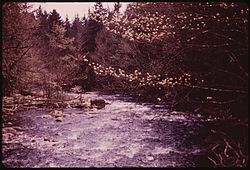
33:North Branch Moose River in 1973
27:
16:River in New York, United States
128: • coordinates
1:
64:Physical characteristics
167: • elevation
116: • location
88: • location
381:
345:Rivers of New York (state)
189:is a mountain waterway in
98:
77:Middle Branch Moose River
68:
26:
171:849 ft (259 m)
81:South Branch Moose River
298:List of New York rivers
150:43.61306°N 75.33667°W
121:Lyons Falls, New York
155:43.61306; -75.33667
146: /
253:Owing to its high
215:Fulton Chain Lakes
93:McKeever, New York
183:
182:
372:
205:. The outlet of
191:Upstate New York
161:
160:
158:
157:
156:
151:
147:
144:
143:
142:
139:
89:
31:
19:
380:
379:
375:
374:
373:
371:
370:
369:
335:
334:
316:
311:
287:
251:
231:Herkimer County
223:Hamilton County
211:Herkimer County
168:
154:
152:
148:
145:
140:
137:
135:
133:
132:
129:
117:
87:
34:
17:
12:
11:
5:
378:
376:
368:
367:
362:
357:
352:
347:
337:
336:
333:
332:
327:
322:
315:
314:External links
312:
310:
307:
306:
305:
300:
295:
286:
283:
250:
247:
207:Big Moose Lake
181:
180:
177:
173:
172:
169:
166:
163:
162:
130:
127:
124:
123:
118:
115:
112:
111:
106:
100:
99:
96:
95:
90:
84:
83:
74:
70:
69:
66:
65:
61:
60:
55:
51:
50:
45:
41:
40:
36:
35:
32:
24:
23:
15:
13:
10:
9:
6:
4:
3:
2:
377:
366:
363:
361:
358:
356:
353:
351:
348:
346:
343:
342:
340:
331:
328:
326:
323:
321:
318:
317:
313:
308:
304:
301:
299:
296:
294:
293:
289:
288:
284:
282:
280:
275:
273:
269:
265:
260:
256:
248:
246:
244:
240:
236:
232:
228:
224:
220:
216:
212:
208:
204:
200:
199:Middle Branch
196:
192:
188:
178:
174:
170:
164:
159:
131:
125:
122:
119:
113:
110:
107:
105:
101:
97:
94:
91:
85:
82:
78:
75:
71:
67:
62:
59:
56:
52:
49:
48:United States
46:
42:
37:
30:
25:
20:
290:
276:
266:and eastern
252:
235:Lewis County
226:
203:South Branch
195:North Branch
186:
184:
243:Lyons Falls
239:Black River
227:Moose River
187:Moose River
153: /
109:Black River
22:Moose River
339:Categories
309:References
279:hydropower
259:whitewater
176:Basin size
141:75°20′12″W
138:43°36′47″N
303:Old Forge
249:Geography
219:Old Forge
285:See also
255:gradient
201:and the
58:New York
39:Location
272:Class-V
44:Country
268:Canada
197:, the
73:Source
233:into
104:Mouth
54:State
185:The
241:in
217:in
341::
264:US
245:.
79:,
Text is available under the Creative Commons Attribution-ShareAlike License. Additional terms may apply.