46:
76:
29:
381:, a town in southern Brown County, had to be abandoned due to the path of the backwaters. Therefore, the town was acquired through the power of eminent domain. Later, this was found not to be necessary; the result of a mistake in elevation estimates. The lake was designed as a primary water source for the City of Bloomington and to prevent flood damage downstream. The lake was created and is still managed by the
83:
53:
491:
360:
camp comprising over 624 acres (253 ha), is situated along the eastern shore with a private dock system in Siscoe Bay (also known as Boy Scout Bay). The largest marina situated on the lake is the
Fourwinds Resort and Marina with over 800 boats. The reservoir provides abundant fishing throughout
342:. Capacity varies from 292 gigalitres (237,000 acre⋅ft) to 428 gigalitres (347,000 acre⋅ft) depending on water level. It is also home to 13,202 acres (53.43 km) of protected forest and three recreational areas (Fairfax, Hardin Ridge, and Paynetown). Indiana's only federally protected
350:, is located on the south shore. The lake's watershed is 441 square miles, 82% of which is forested or farmland. The pool elevation (above sea level) is about 538 feet (164 m) year-round. During colder winters, limited ice fishing is available on protected backwater portions of the reservoir.
557:
572:
537:
567:
532:
45:
75:
134:
473:
562:
361:
the year, and recreational opportunities such as boating and water skiing attract visitors from throughout
Indiana and the Midwest.
417:
547:
373:
was dammed south of
Bloomington, Indiana and the reservoir fills the valley to the northeast of the dam extending into adjacent
347:
542:
382:
495:
507:
353:
552:
370:
199:
185:
335:
108:
374:
357:
339:
192:
112:
402:
378:
343:
319:
178:
369:
Construction on the lake began in 1960 and was finished in 1965 at a cost of $ 16.5 million.
302:
424:
28:
206:
526:
327:
212:
166:
120:
334:
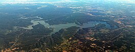
with 10,750 acres (43.5 km) of water surface area spread over the counties of
275:
149:
136:
449:
315:
171:
490:
403:"Longest Lake Shorelines - Lake Shoreline Lengths in Miles - LakeLubbers"
331:
323:
179:
116:
502:
193:
512:
517:
418:"Water Quality Modeling of Lake Monroe Using CE-QUAL-W2"
503:
Monroe Lake page at
Indiana Dept. of Natural Resources
16:
Reservoir in Brown and Monroe counties, Indiana, U.S.
292:
284:
274:
238:
230:
222:
218:
205:
191:
177:
165:
126:
104:
21:
513:U.S. Army Corps of Engineers, Louisville District
318:located about 10 miles (16 km) southeast of
508:Monroe Lake page at U.S. Army Corps of Engineers
330:. The lake is the largest entirely situated in
127:
8:
423:. US Army Corps of Engineers. Archived from
558:United States Army Corps of Engineers dams
18:
573:Bodies of water of Monroe County, Indiana
538:Protected areas of Monroe County, Indiana
568:Bodies of water of Brown County, Indiana
533:Protected areas of Brown County, Indiana
394:
7:
82:
52:
14:
489:
81:
74:
51:
44:
27:
348:Charles C. Deam Wilderness Area
346:, the 13,000-acre (53 km)
291:
283:
273:
237:
229:
221:
1:
103:
95:Show map of the United States
33:Aerial of Monroe Lake in 2019
383:U.S. Army Corps of Engineers
226:10,750 acres (4,350 ha)
589:
354:Ransburg Scout Reservation
303:not a well-defined measure
563:Nature centers in Indiana
300:
288:190 mi (310 km)
38:
26:
296:538 ft (164 m)
548:Hoosier National Forest
385:, Louisville District.
377:. It was thought that
454:Friends of Lake Monroe
234:59 ft (18 m)
543:Reservoirs in Indiana
498:at Wikimedia Commons
474:"Monroe Lake Cutaway"
344:U.S. Wilderness Area
276:Residence time
150:39.0587°N 86.4464°W
146: /
65:Show map of Indiana
250:10 cubic feet (292
494:Media related to
309:
308:
293:Surface elevation
155:39.0587; -86.4464
580:
493:
478:
477:
470:
464:
463:
461:
460:
446:
440:
439:
437:
435:
429:
422:
413:
407:
406:
399:
301:Shore length is
266:
265:
256:
255:
249:
245:
195:
194:Primary outflows
181:
161:
160:
158:
157:
156:
151:
147:
144:
143:
142:
139:
129:
96:
85:
84:
78:
66:
55:
54:
48:
31:
19:
588:
587:
583:
582:
581:
579:
578:
577:
553:Dams in Indiana
523:
522:
518:Lake-Monroe.com
487:
482:
481:
472:
471:
467:
458:
456:
448:
447:
443:
433:
431:
430:on 28 July 2013
427:
420:
415:
414:
410:
401:
400:
396:
391:
367:
263:
261:
253:
251:
247:
243:
209: countries
180:Primary inflows
154:
152:
148:
145:
140:
137:
135:
133:
132:
100:
99:
98:
97:
94:
93:
92:
91:
90:
86:
69:
68:
67:
64:
63:
62:
61:
60:
56:
34:
17:
12:
11:
5:
586:
584:
576:
575:
570:
565:
560:
555:
550:
545:
540:
535:
525:
524:
521:
520:
515:
510:
505:
486:
485:External links
483:
480:
479:
465:
441:
416:Cole, Thomas.
408:
393:
392:
390:
387:
366:
363:
307:
306:
298:
297:
294:
290:
289:
286:
282:
281:
278:
272:
271:
240:
236:
235:
232:
228:
227:
224:
220:
219:
216:
215:
210:
203:
202:
197:
189:
188:
183:
175:
174:
169:
163:
162:
130:
124:
123:
106:
102:
101:
88:
87:
80:
79:
73:
72:
71:
70:
58:
57:
50:
49:
43:
42:
41:
40:
39:
36:
35:
32:
24:
23:
15:
13:
10:
9:
6:
4:
3:
2:
585:
574:
571:
569:
566:
564:
561:
559:
556:
554:
551:
549:
546:
544:
541:
539:
536:
534:
531:
530:
528:
519:
516:
514:
511:
509:
506:
504:
501:
500:
499:
497:
492:
484:
475:
469:
466:
455:
451:
445:
442:
426:
419:
412:
409:
404:
398:
395:
388:
386:
384:
380:
376:
372:
364:
362:
359:
355:
351:
349:
345:
341:
337:
333:
329:
328:United States
325:
321:
317:
313:
304:
299:
295:
287:
279:
277:
269:
259:
241:
233:
225:
217:
214:
213:United States
211:
208:
204:
201:
198:
196:
190:
187:
184:
182:
176:
173:
170:
168:
164:
159:
131:
125:
122:
121:United States
118:
114:
110:
107:
77:
47:
37:
30:
25:
20:
488:
468:
457:. Retrieved
453:
444:
432:. Retrieved
425:the original
411:
397:
375:Brown County
368:
365:Construction
352:
311:
310:
285:Shore length
280:185–408 days
267:
257:
239:Water volume
223:Surface area
496:Monroe Lake
434:30 December
379:Elkinsville
320:Bloomington
312:Monroe Lake
153: /
128:Coordinates
89:Monroe Lake
59:Monroe Lake
22:Monroe Lake
527:Categories
459:2023-10-12
389:References
371:Salt Creek
356:, a large
246:10 to 1.51
231:Max. depth
200:Salt Creek
186:Salt Creek
141:86°26′47″W
138:39°03′31″N
115:counties,
358:Boy Scout
316:reservoir
172:Reservoir
270: m)
105:Location
450:"About"
332:Indiana
324:Indiana
117:Indiana
336:Monroe
260:to 428
109:Monroe
428:(PDF)
421:(PDF)
340:Brown
314:is a
207:Basin
113:Brown
436:2011
338:and
242:1.03
167:Type
529::
452:.
326:,
322:,
264:10
254:10
119:,
111:/
476:.
462:.
438:.
405:.
305:.
268:^
262:×
258:^
252:×
248:×
244:×
Text is available under the Creative Commons Attribution-ShareAlike License. Additional terms may apply.