31:
258:
39:
222:
314:
339:
295:
324:
329:
319:
178:
163:
194:
155:
344:
288:
281:
58:
334:
119:
175:
85:
74:
66:
62:
54:
100:
89:
77:. In far southwestern Brown County and much of southern Monroe County, the creek flows through
207:
265:
70:
30:
182:
159:
152:
99:
Salt Creek, according to data collected from the years 1956–2001 at the USGS station at
17:
308:
257:
107:
92:. Besides the street runoff from Bloomington, Clear Creek also brings with it the
78:
237:
224:
50:
38:
209:
Counties of Morgan, Monroe and Brown, Indiana: Historical and
Biographical
139:
93:
37:
29:
49:
is a stream in the southern part of the U.S. state of
Indiana. A
103:, has a mean annual discharge of 495 cubic feet per second.
96:
from the city's
Dillman Road Wastewater Treatment Plant.
69:
counties, and meets the White River just downstream from
269:
153:
Water
Quality Modeling of Lake Monroe Using CE-QUAL-W2
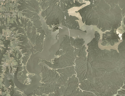
81:, which was created by damming the creek in 1965.
264:This article related to a river in Indiana is a
106:Salt Creek was so named on account of the many
289:
8:
296:
282:
212:. F.A. Battey & Company. p. 536.
131:
315:Rivers of Bartholomew County, Indiana
166:, 1999-01, 1-2. Accessed 2015-03-02.
164:United States Army Corps of Engineers
7:
340:Midwestern United States river stubs
254:
252:
88:, which drains most of the city of
84:A major tributary of Salt Creek is
57:, the creek begins in southwestern
325:Rivers of Lawrence County, Indiana
268:. You can help Knowledge (XXG) by
61:, flows through southern parts of
25:
27:Stream in the South Indiana, U.S.
330:Rivers of Monroe County, Indiana
256:
320:Rivers of Brown County, Indiana
1:
42:Satellite view of Monroe Lake
34:Salt Creek above Monroe Lake
206:Blanchard, Charles (1884).
361:
251:
120:List of rivers of Indiana
138:U.S. Geological Survey.
53:of the East Fork of the
18:Salt Creek (White River)
345:Indiana geography stubs
142:. Accessed 2011-05-29.
43:
35:
238:38.82833°N 86.54806°W
185:(City of Bloomington)
41:
33:
176:Water Basics: Stream
101:Harrodsburg, Indiana
243:38.82833; -86.54806
234: /
181:2012-09-16 at the
158:2013-07-28 at the
110:along its course.
59:Bartholomew County
44:
36:
335:Rivers of Indiana
277:
276:
16:(Redirected from
352:
298:
291:
284:
260:
253:
249:
248:
246:
245:
244:
239:
235:
232:
231:
230:
227:
214:
213:
203:
197:
192:
186:
173:
167:
149:
143:
140:The National Map
136:
21:
360:
359:
355:
354:
353:
351:
350:
349:
305:
304:
303:
302:
242:
240:
236:
233:
228:
225:
223:
221:
220:
218:
217:
205:
204:
200:
195:USGS Water data
193:
189:
183:Wayback Machine
174:
170:
160:Wayback Machine
151:Cole, Thomas. "
150:
146:
137:
133:
128:
116:
75:Lawrence County
28:
23:
22:
15:
12:
11:
5:
358:
356:
348:
347:
342:
337:
332:
327:
322:
317:
307:
306:
301:
300:
293:
286:
278:
275:
274:
261:
216:
215:
198:
187:
168:
144:
130:
129:
127:
124:
123:
122:
115:
112:
26:
24:
14:
13:
10:
9:
6:
4:
3:
2:
357:
346:
343:
341:
338:
336:
333:
331:
328:
326:
323:
321:
318:
316:
313:
312:
310:
299:
294:
292:
287:
285:
280:
279:
273:
271:
267:
262:
259:
255:
250:
247:
211:
210:
202:
199:
196:
191:
188:
184:
180:
177:
172:
169:
165:
161:
157:
154:
148:
145:
141:
135:
132:
125:
121:
118:
117:
113:
111:
109:
108:brine springs
104:
102:
97:
95:
91:
87:
82:
80:
76:
72:
68:
64:
60:
56:
52:
48:
40:
32:
19:
270:expanding it
263:
219:
208:
201:
190:
171:
147:
134:
105:
98:
83:
46:
45:
241: /
90:Bloomington
86:Clear Creek
79:Monroe Lake
55:White River
309:Categories
229:86°32′53″W
226:38°49′42″N
126:References
47:Salt Creek
51:tributary
179:Archived
156:Archived
114:See also
94:effluent
71:Bedford
67:Monroe
63:Brown
266:stub
162:".
65:and
73:in
311::
297:e
290:t
283:v
272:.
20:)
Text is available under the Creative Commons Attribution-ShareAlike License. Additional terms may apply.