49:
284:
82:
89:
56:
29:
485:
493:
329:
population was preserved during the species great dieback after
European colonisation and may have allowed more rapid repopulation in the Taupō area.
599:
48:
287:
Motutaiko Island's location in Taupo showing relationship to recent volcanic vents in red and present active geothermal systems in light blue.
558:
594:
356:
of Lake Taupō, named
Horomatangi, is said to live in a cave on the island's northeastern face. The creature is also said to be the pet of
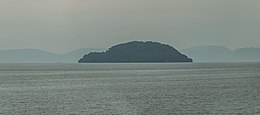
276:. The island was likely formed after an underwater magma vent's releases cooled and hardened into a cone, with Motutaiko forming the
81:
619:
134:
589:
609:
517:"Site survey and evaluation of trapping and identification techniques for small scaled skinks (oligosoma microlepis)"
604:
446:
534:
283:
624:
445:
Illsley-Kemp, Finnigan; Barker, Simon J.; Wilson, Colin J. N.; Chamberlain, Calum J.; Hreinsdóttir, Sigrún;
420:
614:
402:
248:
346:
342:
326:
449:; Hamling, Ian J.; Savage, Martha K.; Mestel, Eleanor R. H.; Wadsworth, Fabian B. (1 June 2021).
318:
304:
357:
243:
462:
273:
277:
338:
325:
was captured there in 1971 before being found elsewhere in the central North Island. Its
309:
34:
583:
231:
122:
516:
235:
239:
213:
451:"Volcanic Unrest at Taupō Volcano in 2019: Causes, Mechanisms and Implications"
28:
292:
377:
246:, with "motu" meaning island, and "taiko" being a name for the black petrel (
149:
136:
314:
295:
directly under
Motutaiko Island compared to adjacent areas of Lake Taupo.
467:
450:
266:
353:
341:, and landing on the island is therefore prohibited by the government.
349:, was buried in a sacred cave on the island in the late 18th century.
242:. It sits near the town of Motutere. The name "Motutaiko" is from the
227:
322:
282:
269:
559:"Motutaiko Island / Places of significant interest in Taupo"
535:"Notes on the occurrence of the Bellbird in North Auckland"
313:. Other animals present on the island include a colony of
205:
197:
189:
181:
173:
165:
128:
118:
113:
553:
551:
280:at 452 m (1,483 ft) above sea level.
265:Motutaiko Island is formed out of a column of
68:Motutaiko Island's location within New Zealand
337:The island is spiritually significant to the
8:
21:
272:, connected to the geologic systems of the
27:
20:
466:
291:There has recently been little volcanic
88:
55:
414:
412:
369:
480:
478:
7:
455:Geochemistry, Geophysics, Geosystems
16:Island on New Zealand's North Island
321:. The type specimen for this small
14:
87:
80:
54:
47:
600:Volcanic islands of New Zealand
101:Motutaiko Island (North Island)
307:live on the island, including
33:Motutaiko Island as seen from
1:
595:Lake islands of New Zealand
515:Gebauer, Konstanze (2008).
403:"NZTopMap:Motutaiko Island"
193:1,500 m (4900 ft)
641:
210:
201:452 m (1483 ft)
185:550 m (1800 ft)
177:400 m (1300 ft)
41:
26:
104:Show map of North Island
345:, a major chief of the
71:Show map of New Zealand
533:Turbott, E.G. (1953).
382:gazetteer.linz.govt.nz
288:
249:Procellaria parkinsoni
198:Highest elevation
343:Te Rangi-tua-matotoru
286:
169:11 ha (27 acres)
468:10.1029/2021GC009803
620:Taupō Volcanic Zone
544:. pp. 175–178.
419:Stout, Sir Robert.
146: /
23:
590:Islands of Waikato
486:"Motutaiko Island"
378:"Motutaiko Island"
319:small-scaled skink
305:endangered species
289:
150:38.854°S 175.942°E
221:
220:
632:
574:
573:
571:
569:
555:
546:
545:
539:
530:
524:
523:
521:
512:
506:
505:
503:
501:
492:. Archived from
482:
473:
472:
470:
442:
436:
435:
433:
431:
416:
407:
406:
399:
393:
392:
390:
388:
374:
347:Ngāti Tūwharetoa
256:Natural features
161:
160:
158:
157:
156:
155:-38.854; 175.942
151:
147:
144:
143:
142:
139:
105:
95:Motutaiko Island
91:
90:
84:
72:
62:Motutaiko Island
58:
57:
51:
31:
24:
22:Motutaiko Island
640:
639:
635:
634:
633:
631:
630:
629:
610:Māori mythology
580:
579:
578:
577:
567:
565:
563:Living Heritage
557:
556:
549:
537:
532:
531:
527:
519:
514:
513:
509:
499:
497:
496:on 4 March 2014
484:
483:
476:
444:
443:
439:
429:
427:
418:
417:
410:
401:
400:
396:
386:
384:
376:
375:
371:
366:
358:Ngātoro-i-rangi
335:
333:Maori tradition
301:
263:
258:
224:Motuaiko Island
217:
154:
152:
148:
145:
140:
137:
135:
133:
132:
109:
108:
107:
106:
103:
102:
99:
98:
97:
96:
92:
75:
74:
73:
70:
69:
66:
65:
64:
63:
59:
37:
17:
12:
11:
5:
638:
636:
628:
627:
625:Sacred islands
622:
617:
612:
607:
605:Taupō District
602:
597:
592:
582:
581:
576:
575:
547:
525:
507:
474:
437:
408:
394:
368:
367:
365:
362:
334:
331:
310:Wainuia clarki
300:
297:
262:
259:
257:
254:
244:Māori language
219:
218:
211:
208:
207:
206:Administration
203:
202:
199:
195:
194:
191:
187:
186:
183:
179:
178:
175:
171:
170:
167:
163:
162:
130:
126:
125:
120:
116:
115:
111:
110:
100:
94:
93:
86:
85:
79:
78:
77:
76:
67:
61:
60:
53:
52:
46:
45:
44:
43:
42:
39:
38:
35:Tauranga Taupo
32:
15:
13:
10:
9:
6:
4:
3:
2:
637:
626:
623:
621:
618:
616:
613:
611:
608:
606:
603:
601:
598:
596:
593:
591:
588:
587:
585:
564:
560:
554:
552:
548:
543:
536:
529:
526:
518:
511:
508:
495:
491:
487:
481:
479:
475:
469:
464:
460:
456:
452:
448:
441:
438:
426:
422:
415:
413:
409:
404:
398:
395:
383:
379:
373:
370:
363:
361:
359:
355:
350:
348:
344:
340:
332:
330:
328:
324:
320:
316:
312:
311:
306:
298:
296:
294:
285:
281:
279:
275:
274:Taupō Volcano
271:
268:
260:
255:
253:
251:
250:
245:
241:
237:
233:
229:
225:
216:
215:
209:
204:
200:
196:
192:
188:
184:
180:
176:
172:
168:
164:
159:
131:
127:
124:
121:
117:
112:
83:
50:
40:
36:
30:
25:
19:
566:. Retrieved
562:
541:
528:
510:
498:. Retrieved
494:the original
489:
458:
454:
447:Ellis, Susan
440:
428:. Retrieved
424:
421:"Lake Taupo"
397:
385:. Retrieved
381:
372:
351:
339:Māori people
336:
308:
302:
290:
264:
247:
236:North Island
226:is the only
223:
222:
212:
18:
461:(6): 1–27.
240:New Zealand
214:New Zealand
153: /
141:175°56′31″E
129:Coordinates
615:Lake Taupō
584:Categories
387:20 January
364:References
315:cormorants
293:seismicity
232:Lake Taupō
138:38°51′14″S
123:Lake Taupō
568:4 October
500:4 October
430:4 October
267:rhyolitic
190:Coastline
114:Geography
542:Notornis
327:bellbird
317:and the
303:Several
119:Location
354:taniwha
299:Biology
261:Geology
234:on the
230:within
490:NZ DOC
228:island
174:Length
538:(PDF)
520:(PDF)
425:NZTEC
323:skink
182:Width
570:2020
502:2020
432:2020
389:2022
352:The
278:apex
270:lava
166:Area
463:doi
252:).
238:of
586::
561:.
550:^
540:.
488:.
477:^
459:22
457:.
453:.
423:.
411:^
380:.
360:.
572:.
522:.
504:.
471:.
465::
434:.
405:.
391:.
Text is available under the Creative Commons Attribution-ShareAlike License. Additional terms may apply.