1245:
1095:
621:
193:
158:
151:
38:
760:
784:
186:
1317:
than probably plugs of volcanic vents and lava-flows; and it would seem reasonable to infer that the lake owes its origin, firstly, to eruption, which was followed by a subsidence, and that subsequently some of the vents within it continued active as subaqueous volcanoes, the ejecta from which now form the comparatively level floor of the lake, having been worn away from the cones by denudation.
804:
567:
magma is evolving. Studies show large areas of partial melt below 10 km (6.2 mi) with a brittle-ductile rosk transition at approximately 6–8 km (3.7–5.0 mi) beneath the surface. For unknown as yet reasons, possibly associated with the present high rate of rift spreading and the recent subduction of the
1290:
was published as the first geological map of the area and this shows a rim of rhyolytic deposits around all the northern two thirds of the shore line of Lake Taupō but without the full extent of the relevant surface deposits being characterised. The area did not have a further high quality geological
898:
The Hatepe eruption (also known as the Taupō or
Horomatangi Reef Unit Y eruption) represents the most recent major eruption of the Taupō Volcano, and occurred about 1,800 years ago. It was the most powerful eruption in the world in the last 5,000 years. The type of eruption that occurred is the most
1316:
the jagged appearance of the volcanic rocks forming the steep northern and western shores leads at once to the conclusion that they were separated from the masses of which they originally formed part by some violent agency, either of eruption or subsidence. The islands and reefs in the lake are more
1170:
While no witnessed eruptive event has been recorded from Taupō, there have been seventeen episodes of volcanic unrest since 1872, with the most recent being in 2019 and 2022–2023. This manifested as swarms of seismic activity and ground deformation within the caldera. The present-day magma reservoir
656:
Map so centered to show approximate selected surface volcanic deposits, including all the present surface
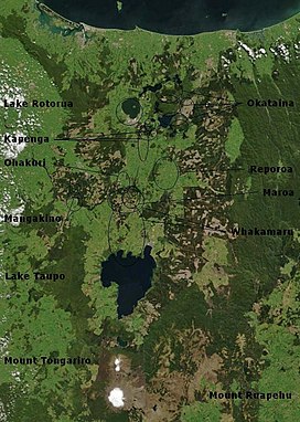
Oruanui and Hatepe ignimbrites. Tephra from these eruptions was much more widespread. Clicking on the map enlarges it, and enables panning and mouseover of volcano name/wikilink and ages before
566:
starts about 25–30 km (16–19 mi) beneath the surface beyond the modern Taupō Rift boundaries to the west and east, but there is an area of strong contrast in seismic velocity at 16 kn (30 km/h; 18 mph) depth that is postulated to be due to intruded crust from where the feed
1346:
from 1980 onward. The
Oruanui eruption also became better understood with for example the influence of the eruptions on the sedimentology of the region taking several decades more to unravel. Volcanology better modeled the processes of magma formation and eruption, with wider acceptance of a
496:
Taupō Volcano has not erupted for approximately 1,800 years; however, with research beginning in 1979 and published in 2022, the data collated over the 42-year period shows that Taupō Volcano is active with periods of volcanic unrest and has been for some time. Some volcanoes within the Taupō
1037:
valley and released over a short period 2.5 km (0.60 cu mi) of water. The previous outlet of Lake Taupō was blocked, raising the lake 35 m (115 ft) above its present level, until shortly after the first smaller flood, it broke out in a huge flood, that released about
2808:"The southern part of the Province of Auckland showing the routes and surveys by Ferdinand von Hochstetter, 1859 from the original drawings, sketches and measurements by Dr von Hochstetter and the admiralty surveys by Stokes and Drury, compiled by A. Peterman. Gotha, Justus Pertes, 1864"
943:
The most destructive part of the eruption then occurred. Part of the vent area collapsed, as part of a process that unleashed about 30 km (7.2 cu mi) of material, that formed a fast-moving, 600–900 km/h (370–560 mph) pyroclastic flow lasting no more than 15
935:
A larger dry eruption ensued, which erupted 7.7 km (1.8 cu mi) ash/pumice over a huge area, over up to 17 hours, before partial column collapse with as many as eleven dry pyroclastic flow density currents resulting in 1.5 km (0.36 cu mi) of local
1174:
Unrest from May 1922 to
January 1923 saw several thousand earthquakes, with the highest reaching magnitude 6, causing chimneys to collapse. The events were misreported internationally, which caused self-evacuations and a drop in tourism in Taupō and Rotorua. A source in
2953:
Rooyakkers, SM; Chambefort, I; Faure, K; Wilson, CJ; Barker, SJ; Mortimer, N; Elms, HC; Troch, J; Charlier, BL; Leonard, GS; Farsky, D (2023). "Absence of low-δ18O magmas despite widespread assimilation of altered crust in a large magmatic and hydrothermal province".
493:, dated 232 ± 10 CE. There have been many more eruptions, with major ones every thousand years or so (see timeline of last 10,000 years of eruptions). The Oruanui eruption in particular destroyed or obscured much evidence of previous eruptive activity.
1426:
to 25.675 ± 0.09 ka cal BP. In 2022 the ice core date of 25.318 ± .25 ka BP using the WD2014 timescale was corrected to 25.718 ka. The review article used here as source says around 25,500 years ago which is not a precise statement like the later 2022 corrections.
1583:
Dong, Xiyu; Kathayat, Gayatri; Rasmussen, Sune O.; Svensson, Anders; Severinghaus, Jeffrey P.; Li, Hanying; Sinha, Ashish; Xu, Yao; Zhang, Haiwei; Shi, Zhengguo; Cai, Yanjun; Pérez-Mejías, Carlos; Baker, Jonathan; Zhao, Jingyao; Spötl, Christoph (4 October 2022).
1182:
While Taupō is capable of very large eruptions these remain very unlikely as the majority of the 29 eruptions of various magnitudes in the last 30,000 years have been much smaller. Many have been dome-forming, which may have contributed to lake features such as
1074:
in Rome were due to this eruption, which would give a date of exactly 186. However, ash from volcanic activity does not normally cross hemispheres, and radiocarbon dating by R. Sparks has put the date at 233 CE ± 13 (95% confidence). A 2011 C
1127:
is ill-defined but most of the seismic activity is likely related to structures related to this caldera. While studies have identified one Taupō composition vent 20 km (12 mi) to the north of Lake Taupō, this presumably resulted from a
1303:
who was
Director of the New Zealand Geological Survey from 1865. When commissioned to provide the first official report on the 1886 eruption from Tarawera his travels included Taupō. The resulting report conclusion on the cause of the eruption
628:
Earlier ignimbrite eruptions occurred further north than Taupō. Some of these were enormous, and two eruptions around 1.25 and 1.0 million years ago were big enough to generate an ignimbrite sheet that covered the North Island from
1323:
first crystallised the possibility in the geological literature that there was a volcano under Lake Taupō as the likely source of the extensive surface pumice deposits from field work including analysis of specimens forwarded by Cussen.
2367:
Manville, V.; Segschneider, B.; Newton, E.; White, J.D.L.; Houghton, B.F.; Wilson, C.J.N. (2009). "Environmental impact of the 1.8 ka Taupo eruption, New
Zealand: Landscape responses to a large-scale explosive rhyolite eruption".
1122:
Composition studies suggest the Taupō Volcano has had historic vents to the south and north of the present lake, and recent seismic activity does extend beyond the lake to its north and south. To the north the border with the
517:
most recently in
December 2019. Geologic studies published in 1888 following the eruption of Mount Tarawera first raised the possibility that there was a volcano under Lake Taupō, rather than the more obvious volcanoes near
1654:
Hogg, Alan; Lowe, David J.; Palmer, Jonathan; Boswijk, Gretel; Ramsey, Christopher Bronk (2011). "Revised calendar date for the Taupo eruption derived by C wiggle-matching using a New
Zealand kauri C calibration data set".
1883:
1327:
In 1937 it was recognised that the deposit from the Hatepe eruption had been so hot to burn the forest over a 160 km (99 mi) distance, but this was not recognised as being due to a pyroclastic flow until 1956.
1295:, and the discourse following this nearby eruption resulted in a much better understanding of volcanoes, including Taupō, so will be considered for context, to explain the shift in understanding from 1886 to 1888.
2224:
Harper, MA; Pledger, SA; Smith, EG; Van Eaton, AR; Wilson, CJ (2015). "Eruptive and environmental processes recorded by diatoms in volcanically dispersed lake sediments from the Taupo
Volcanic Zone, New Zealand".
2992:
1028:
The eruption further expanded the lake, which had formed after the much larger
Oruanui eruption. Its new deposits also briefly created another large lake to the Taupō Volcano's north that extended to the
608:, hitting the surface like water from a waterfall, and spreading sideways across the land at enormous speed. When the pumice and ash settle, they are sufficiently hot to stick together as a rock called
1270:
described euptives now known to have been from the Taupō Volcano in his 1843 publication on New Zealand, but like many others until 1886 assigned them to the stratovolcanoes to the south of Lake Taupō.
2397:
1526:
Dunbar, Nelia W.; Iverson, Nels A.; Van Eaton, Alexa R.; Sigl, Michael; Alloway, Brent V.; Kurbatov, Andrei V.; Mastin, Larry G.; McConnell, Joseph R.; Wilson, Colin J. N. (25 September 2017).
1194:
Earthquake and tsunami hazards also exist. While most earthquakes are relatively small and associated with magma shifts, the moderate earthquakes associated with eruptions or the numerous
932:-rich 1.1 km (0.26 cu mi) fall deposit, the Rotongaio fine phreatoplinian ash. At the end of the last phase or beginning of this there was a period of heavy rainfall.
1875:
3043:
1140:
triggered a deformation event in the north-west portion of the volcano without seismic or deformation events being observed in closer volcanoes to that earthquake's epicentre.
2478:
1800:
1761:
A continent on the move: New Zealand geoscience into the 21st century. Graham, Ian J. et al.; The Geological Society of New Zealand in association with GNS Science, 2008.
93:
550:
content, a feature associated with the middle portion of the Taupō Volcanic Zone within the Taupō Rift. This is an intra-arc rift in the eastern part of the continental
2344:
Sedimentology and history of Lake Reporoa: an ephemeral supra-ignimbrite lake, Taupo Volcanic Zone, New Zealand in Volcaniclastic sedimentation in lacustrine settings
2268:
Wilson, C.J.N. and Walker, G.P.L., 1985. The Taupō eruption, New Zealand I. General aspects. Philosophical Transactions of the Royal Society of London, A314: 199–228.
1279:
and interpreted the lake amongst the others in the region as caused by collapse in a volcanic plateau, but was unable to investigate to exclude other possibilities.
856:
but the total impact of this eruption was somewhat greater. Most of New Zealand was affected by ashfall, with an 18 cm (7.1 in) ash layer left even on the
1306:
I think there can be little question that it is a purely hydro-thermal phenomenon, but on a gigantic scale; that it is quite local and not of deep-seated origin...
1232:. Monitoring of a volcano situated under a lake is challenging, and an eruption might occur with little or no meaningful notice. Live data can be viewed on the
469:
1202:, for example, has been associated with 6.5 magnitude earthquakes at recurrence intervals of between 490 and 1,380 years and at least one tsunami related to
2394:
604:
If the material thrown out cools more rapidly and becomes denser than the air, it cannot rise as high, and suddenly collapses back to the ground, forming a
1477:
Muscheler, Raimund; Adolphi, Florian; Heaton, Timothy J; Bronk Ramsey, Christopher; Svensson, Anders; van der Plicht, Johannes; Reimer, Paula J (2020).
1342:
Further understanding of the size of the Hatepe eruption from the Taupō volcano with its pyroclastic flows and vent location resulted from the work of
1136:. As of 2024 it is possible that Taupō is in a state of internal instability that is susceptible to dynamic triggering by tectonic earthquakes, as the
2909:. Vol. 73. Wellington: New Zealand Geological Survey. Bulletin N. S. New Zealand Department of Scientific and Industrial Research. pp. 1–88.
775:
flow (yellow shading). The central red area is the Oruanui caldera with surrounding collapse crater in lighter red. It is superimposed on present day
1452:
811:
The Oruanui eruption (also known as the Kawakawa event) of the Taupō Volcano was the world's largest known eruption in the past 70,000 years, with a
1418:
The age of the Oruanui eruption has been determined by several independent methods and may be subject to further correction. A previous age of 26.5
1252:
While volcanism was recognised in the area following human occupation the recognition of the presence of a large volcano under Lake Taupō was not.
1244:
2831:
2687:
Gómez-Vasconcelos, Martha; Villamor, Pilar; Procter, Jon; Palmer, Alan; Cronin, Shane; Wallace, Clel; Townsend, Dougal; Leonard, Graham (2018).
1003:
more material off the ground surface than it replaced with ignimbrite. Valleys were filled with ignimbrite, evening out the shape of the land.
1766:
1179:
incorrectly reported that there had been 60 deaths, when there had been none. Consequentially, the government appointed a publicity officer.
1132:
extusion about 26,000 years ago. Recent activity to the north of the lake is assigned in terms of magma bodies, to the Poihipi volcano under
514:
624:
Recent vents and caldera structures Taupō Volcano. Present active geothermal systems are in light blue. A key to the vents is in the diagram
3127:
1086:, so the nearest humans would have been in Australia and New Caledonia, more than 2,000 km (1,200 mi) to the west and northwest.
925:
A vent erupted mainly wet phreatoplinian ash but some dry magmatic ash to a total of 1.9 km (0.46 cu mi) over tens of hours.
2282:
150:
915:
A minor eruption occurred beneath the ancestral Lake Taupō lasting hours, and producing 0.05 km (0.012 cu mi) of fine ash.
2302:"Giant rafted pumice blocks from the most recent eruption of Taupo volcano, New Zealand: Insights from palaeomagnetic and textural data"
2259:"Taupo the eruption" (a single sheet pamphlet), C.J.N. Wilson and B.F. Houghton, Institute of Geological & Nuclear Sciences, c2004.
2185:"The 26.5 ka Oruanui Eruption, Taupō Volcano, New Zealand: Development, Characteristics and Evacuation of a Large Rhyolitic Magma Body"
2922:"The 26.5 ka Oruanui eruption, New Zealand: A review of the roles of volcanism and climate in the post-eruptive sedimentary response"
2420:
2037:"The 26.5 ka Oruanui eruption, New Zealand: a review of the roles of volcanism and climate in the post-eruptive sedimentary response"
1299:
interpreted this information to postulate that Taupō was a volcano. One of the people responsible for this lack of a survey was Sir
2855:"The Tarawera eruption, 10th June, 1886.-A criticism of Professor Hutton's (and others') explanations of the causes of the eruption"
2470:
2454:
1094:
903:
very high mobility and heat content. It has been stated to have had an energy release equivalent to about 150 ± 50 megatons of TNT.
2665:
2601:
2433:
Stars remained visible during the day; other stars, extending to an enormous length, seemed to be hanging in the middle of the sky.
1796:
852:
with ignimbrite up to 200 m (660 ft) deep. The ignimbrite eruption(s) were possibly not as forceful as that of the later
3122:
3092:
1380:
3031:
2999:"Use of GIS to predict effects of water level on the spawning area for smelt, Retropinna retropinna, in Lake Taupo, New Zealand"
466:
465:
464:
463:
3087:
3082:
1375:
1370:
1292:
1275:
may well have suspected a volcano at Taupō, and certainly identified Lake Taupō as the source of the pumice deposits along the
506:
461:
185:
563:
2351:
827:) and 420 km (100 cu mi) of primary intracaldera material, equivalent to 530 km (130 cu mi) of
972:
The main pyroclastic flow devastated the surrounding area, climbing over 1,500 m (4,900 ft) to overtop the nearby
462:
1019:
were created transiently, the larger first, and the second later smaller and very transient, before the dam at the present
3137:
3117:
3077:
1385:
1331:
The date of the most recent large eruption was first defined in the 1960s as being in the first few centuries AD based on
640:
While Taupō has been active for about 300,000 years, explosive eruptions have been more typical in the last 42,000 years.
527:
383:
2623:
2085:"The Taupō eruption sequence of AD 232±10 in Aotearoa New Zealand: A retrospection (ニュージーランド・タウポ火山における 西暦 232±10 年噴火の推移)"
1343:
86:
2084:
1079:
paper gave the date 232 ± 5 CE. A 2021 review based on five sources reports 232 ± 10 CE.
2689:"Characterisation of faults as earthquake sources from geomorphic data in the Tongariro Volcanic Complex, New Zealand"
820:
365:
2502:"C calibration in the Southern Hemisphere and the date of the last Taupō eruption: evidence from tree-ring sequences"
1137:
1015:
Temporary maximum lake areas after the 232 ± 10 CE Hatepe eruption (dark blue shading). Two temporary
478:
Taupō began erupting about 300,000 years ago. The main eruptions that still affect the surrounding landscape are the
3072:
2568:"No further unusual activity since the M5.6 earthquake beneath Lake Taupō. Volcanic Alert Level remains at Level 1"
1718:
812:
677:
620:
1272:
1160:
928:
Either a short break occurred or two vents became active at the same time with one producing a wet dark ash- and
1171:
is estimated to be at least 250 km (60 cu mi) in volume and have a melt fraction of >20%–30%.
3107:
3102:
3097:
1395:
601:, the pumice and ash are blown sideways, and eventually fall to the ground, draping the landscape like snow.
3112:
2881:
1717:
Illsley-Kemp, Finnigan; Barker, Simon J.; Wilson, Colin J. N.; Chamberlain, Calum J.; Hreinsdóttir, Sigrún;
1423:
467:
449:
2752:
815:
of 8. It occurred around 25,500 years ago and generated approximately 430 km (100 cu mi) of
3132:
1911:
1829:
Barker, SJ; Wilson, CJN; Illsley-Kemp, F; Leonard, GS; Mestel, ERH; Mauriohooho, K; Charlier, BLA (2020).
1448:
1365:
1308:" generated controversy with some supporting this view due to their geological understanding of the time.
1207:
1083:
425:
358:
343:
74:
51:
1253:
1943:
510:
37:
2854:
1319:" He deferred to others who he was collaborating with, in the same timeframe, and as already mentioned
590:, which is thrown out with great force. Such eruptions tend to be earlier in any given eruption cycle.
2807:
2301:
911:
The eruption went through several stages which were redefined in 2003 with at least 3 separate vents:
2907:
Stratigraphy and chronology of late Quaternary volcanic ash in Taupo, Rotorua, and Gisborne districts
2777:
2313:
2196:
2154:
1734:
1664:
1597:
1539:
1490:
1167:
for Taupō Volcano was raised to Volcanic Alert Level 1 (minor volcanic unrest) on 20 September 2022.
1164:
688:
795:
flow (yellow shading). The collapse caldera is in light red. It is superimposed on the present day
634:
244:
2971:
2708:
2242:
2180:
2142:
2124:
2032:
1963:
1850:
1779:
1721:; Hamling, Ian J.; Savage, Martha K.; Mestel, Eleanor R. H.; Wadsworth, Fabian B. (1 June 2021).
1690:
1336:
1332:
1067:
2832:"The recent volcanic eruptions (preliminary report on), by Dr. Hector [with two plans]"
2533:
Schuler, J.; Hreinsdóttir, S.; Illsley‐Kemp, F.; Holden, C.; Townend, J.; Villamor, P. (2024).
2279:
2450:
2347:
2116:
1762:
1633:
1615:
1565:
1508:
1267:
1229:
1225:
568:
441:
980:, and covering the land within 80 ± 10 km (49.7 ± 6.2 mi) with
3010:
2963:
2933:
2700:
2546:
2513:
2377:
2321:
2234:
2204:
2162:
2106:
2096:
2048:
2003:
1955:
1876:"Bed of Lake Taupō rising and falling as magma moves around in active volcano below - study"
1842:
1742:
1680:
1672:
1623:
1605:
1555:
1547:
1498:
1348:
1283:
1261:
1199:
1188:
1184:
973:
954:
900:
816:
792:
772:
649:
605:
559:
551:
486:
79:
1528:"New Zealand supereruption provides time marker for the Last Glacial Maximum in Antarctica"
2414:
2401:
2286:
1390:
1320:
1314:, the District Surveyor in 1887 was unwilling to form a definite conclusion but observed "
1311:
1296:
1148:
1076:
1030:
1016:
977:
919:
893:
857:
853:
594:
519:
490:
489:
about 25,500 years ago, which is responsible for the shape of the modern caldera, and the
2657:
2593:
2567:
2317:
2200:
2158:
1738:
1668:
1601:
1543:
1494:
759:
1783:
1628:
1585:
1560:
1527:
1129:
1063:
877:
783:
498:
2166:
807:
A large eruption column during the Oruanui eruption as it may have appeared from space
421:
has produced two of the world's most powerful eruptions in geologically recent times.
3066:
3047:
3015:
2998:
2975:
2712:
2688:
2325:
2246:
2128:
1967:
1854:
1830:
1694:
1276:
1233:
1176:
1124:
1115:
1107:
1103:
1099:
1034:
1020:
993:
873:
869:
835:
555:
482:
453:
445:
437:
429:
391:
296:
43:
1046:
Many dates have been given for the Hatepe eruption. One estimated date was 181
1006:
All vegetation within the area was flattened. Loose pumice and ash deposits formed
2447:
The First New Zealand Book? — an Eyewitness account of the Taupō eruption of AD 186
2145:(2001). "The 26.5 ka Oruanui eruption, New Zealand: an introduction and overview".
1300:
849:
796:
779:
although at the time New Zealand land mass was larger, as sea level was much lower.
764:
658:
587:
414:
399:
170:
2938:
2921:
2704:
2053:
2036:
1846:
2381:
1287:
1217:
1213:
965:
776:
395:
271:
251:
222:
2209:
2184:
2101:
1723:"Volcanic Unrest at Taupō Volcano in 2019: Causes, Mechanisms and Implications"
1610:
1551:
1479:"Testing and Improving the IntCal20 Calibration Curve with Independent Records"
2967:
2518:
2501:
2238:
1152:
1144:
1102:
seen from its north from low earth orbit with beyond to its south the smaller
1059:
1047:
981:
961:
937:
881:
824:
788:
768:
742:
609:
598:
316:
281:
255:
20:
2726:
2500:
Sparks, R.J.; Melhuish, W.H.; McKee, J.W.A.; Ogden, J.; Palmer, J.G. (1995).
2120:
1676:
1619:
1512:
1198:-associated faults historically have produced tsunami events. The intra-rift
964:
bank. These later smaller eruptions of unknown total size also created large
108:
95:
2886:. Wellington, New Zealand: George Didsbury, Government Printer. pp. 1–5
1352:
1203:
1111:
1055:
950:
947:
575:
411:
321:
262:
2007:
1637:
1569:
1335:. In the 1970s activity was assigned as far back as 330,000 years ago with
1224:
stations. The Horomatangi Reefs area of the lake is associated with active
2471:"Iridium: tracking down the extraterrestrial element in sedimentary clays"
582:, rhyolitic eruptions can be extremely violent. The magma froths to form
2551:
2534:
1959:
1747:
1722:
1133:
1071:
1051:
929:
767:
in terms of approximate 10cm ash deposit (white shading) and approximate
738:
721:
630:
539:
311:
306:
291:
286:
276:
3030:
Rowe, Dave; James, Gavin; Macaulay, Gavin; Shankar, Ude (October 2002).
1503:
1478:
1347:
predominant model for how rhyolite eruptives in these cases formed from
2111:
1999:
Studies on the origins and emplacement of pyroclastic flows (PHD thesis
1257:
1156:
1000:
999:
The power of the pyroclastic flow was so strong that in some places it
989:
985:
865:
839:
578:, and such eruptions are more common. However, when mixed with gas or
418:
403:
348:
326:
301:
232:
47:
1997:
1685:
574:
If the magma does not contain much gas, rhyolite tends to just form a
2300:
von Lichtan, I.J.; White, J.D.L.; Manville, V.; Ohneiser, C. (2016).
861:
845:
711:
667:
583:
547:
523:
479:
64:
2342:
Manville, V (18 April 2001). James D. L. White; N. R. Riggs (eds.).
1942:
Seebeck, H. A.; Nicol, P.; Villamor, J.Ristau; Pettinga, J. (2014).
2652:
2650:
2648:
922:
from a second vent, and 2.5 km (0.60 cu mi) dry ash.
803:
1243:
1093:
1007:
828:
787:
Hatepe eruption impact of a 10-cm ash deposit (white shading) and
782:
758:
619:
579:
543:
502:
1586:"Coupled atmosphere-ice-ocean dynamics during Heinrich Stadial 2"
1355:
basement and fractional crystallisation to produce a magma mush.
2859:
Transactions and Proceedings of the Royal Society of New Zealand
2782:
Transactions and Proceedings of the Royal Society of New Zealand
2535:"The Response of Taupō Volcano to the M7. 8 Kaikōura Earthquake"
1282:
By 1864 information from Hochstetter's 1859 survey and those of
1195:
957:
612:. Pyroclastic flows can travel hundreds of kilometres an hour.
433:
2997:
Rowe, Dave; Shankar, Ude; James, Gavin; Waugh, B (July 2002).
1221:
460:
2658:"GeoNet volcano data underpins new research of Taupō volcano"
1260:
or water monster of the lake, resided in a cave adjacent to
1916:
Wellington, New Zealand: Government Printer. pp. 18–22
1831:"Taupō: an overview of New Zealand's youngest supervolcano"
3032:"High-tech tools for tackling fisheries problems in lakes"
872:
had long-lasting effects on the landscape, and caused the
687: undifferentiated basalts of the Tangihua Complex in
1944:"Structure and kinematics of the Taupo Rift, New Zealand"
1248:
First map showing volcanic nature of Lake Taupō shoreline
1786:, Institute of Geological & Nuclear Sciences, c2004.
522:, to explain the likely source of the extensive surface
1913:
Report on the Eruption of Tarawera and Rotomahana, N.Z.
571:
this area is very productive in its surface volcanism.
968:
and terminated within decades of the major eruption.
2449:. New Plymouth: Trustees of the Dalberton Library.
1797:"Information from GNS Science on the Taupō Volcano"
1712:
1710:
1708:
1706:
1704:
1143:From May through December 2022 there was increased
379:
374:
364:
354:
342:
243:
238:
228:
218:
137:
129:
124:
85:
73:
63:
58:
30:
1472:
1470:
953:were extruded some years later, helping form the
880:to its current course through the Waikato to the
554:, resulting from an oblique convergence with the
918:A dramatic increase in activity produced a high
860:, 850 km (530 mi) away which included
23:, an extinct volcano off the coast of Australia.
2337:
2335:
2041:New Zealand Journal of Geology & Geophysics
2026:
2024:
1778:"Taupo the volcano" (a single sheet pamphlet),
1216:continuously monitors Taupō using a network of
2306:Journal of Volcanology and Geothermal Research
2147:Journal of Volcanology and Geothermal Research
1937:
1935:
1933:
1931:
1351:derived basalts by 20-30% assimilation of the
848:from the eruption covered much of the central
819:deposits, 320 km (77 cu mi) of
2926:New Zealand Journal of Geology and Geophysics
2826:
2824:
2693:New Zealand Journal of Geology and Geophysics
1991:
1989:
1987:
1985:
1983:
1981:
1979:
1977:
1905:
1903:
1901:
1835:New Zealand Journal of Geology and Geophysics
1824:
1822:
1820:
1818:
1098:Taupō Volcano is mainly under the large blue
754:. White shading is selected caldera features.
8:
2920:Manville, Vern; Wilson, Colin J. N. (2004).
2539:Journal of Geophysical Research: Solid Earth
1256:detailed that Horomātangi (Horo-matangi), a
2905:Healy, J; Vucetich, CG; Pullar, WA (1964).
2078:
2076:
2074:
2072:
2070:
2068:
2066:
2064:
1038:20 km (4.8 cu mi) of water.
2089:Journal of Geography (Chigaku Zasshi 地学雑誌)
1649:
1647:
1419:
497:Volcanic Zone have erupted more recently.
27:
3014:
3009:(4). John Wiley & Sons Ltd: 205–216.
2937:
2727:"New Zealand Gazetteer: Horomatangi Reef"
2550:
2517:
2208:
2110:
2100:
2052:
1746:
1684:
1627:
1609:
1559:
1502:
940:deposits to the east of the present lake.
2836:Journals of the House of Representatives
802:
2083:Lowe, David J; Pittari, Adrian (2021).
1440:
1414:
1412:
1408:
1033:which in due course broke out into the
2624:"Caldera Unrest Management Sourcebook"
2604:from the original on 20 September 2022
2423:from the original on 16 September 2019
2668:from the original on 13 February 2022
192:
157:
7:
2002:(Thesis). Imperial College, London.
1803:from the original on 5 February 2018
1727:Geochemistry, Geophysics, Geosystems
996:was high enough to divert the flow.
436:volcanic activity that extends from
2594:"GeoNet Volcanic Activity Bulletin"
2413:Herodian of Antioch. "Chapter 14".
1455:from the original on 27 August 2022
1240:History of geological understanding
1090:Current activity and future hazards
899:extreme volcanic hazard due to the
864:from erupted lake sediments. Later
2566:Kilgour, Geoff (7 December 2022).
1118:covered in this picture with snow.
14:
2481:from the original on 12 July 2022
2280:Field Guide – Taupo Volcanic Zone
1996:Wilson, Colin James Ness (1983).
1886:from the original on 12 July 2022
3016:10.1046/j.1365-2400.2002.00298.x
3003:Fisheries Management and Ecology
2326:10.1016/j.jvolgeores.2016.04.003
1381:List of volcanoes in New Zealand
842:generated during this eruption.
661:that are shown with panning is:
593:If the volcano creates a stable
191:
184:
156:
149:
36:
2956:Geochimica et Cosmochimica Acta
1376:Geothermal power in New Zealand
1371:Geothermal areas in New Zealand
1293:1886 eruption of Mount Tarawera
485:eruption 65,000 years ago, the
1:
2939:10.1080/00288306.2004.9515074
2705:10.1080/00288306.2018.1548495
2167:10.1016/S0377-0273(01)00239-6
2054:10.1080/00288306.2004.9515074
1847:10.1080/00288306.2020.1792515
1386:North Island Volcanic Plateau
745:is lighter shades of violet),
2382:10.1016/j.sedgeo.2009.04.017
1422:, has since been updated to
1082:New Zealand was unpopulated
205:Taupō Volcano (North Island)
3128:Lists of volcanic eruptions
2416:History of the Roman Empire
1449:"NZTopMap:Motutaiko Island"
821:pyroclastic density current
16:Supervolcano in New Zealand
3154:
2346:. Wiley. pp. 109–40.
2102:10.5026/jgeography.130.117
1611:10.1038/s41467-022-33583-4
1552:10.1038/s41598-017-11758-0
1264:on the south of the lake.
1062:. It is possible that the
1042:Dating the Hatepe eruption
1010:down all the main rivers.
891:
813:Volcanic Explosivity Index
671:(shades of brown/orange),
647:
440:in the south, through the
69:452 m (1,483 ft)
18:
2968:10.1016/j.gca.2023.07.004
2880:Cussen, Lawrence (1887).
2519:10.1017/s0033822200030599
2239:10.1007/s10933-015-9851-5
2227:Journal of Paleolimnology
1910:Thomas, A. P. W. (1888).
1273:Ferdinand von Hochstetter
560:Hikurangi subduction zone
538:The Taupō Volcano erupts
501:had a moderately violent
142:
35:
2395:Lake Taupō Official Site
2210:10.1093/petrology/egi066
1677:10.1177/0959683611425551
1396:Volcanism of New Zealand
1138:2016 Kaikōura earthquake
763:Oruanui eruption impact
208:Show map of North Island
19:Not to be confused with
3123:Tsunamis in New Zealand
3093:Calderas of New Zealand
3046:: 24–25. Archived from
2778:"Hochstetter Centenary"
2277:Houghton, B.F. (2007).
1147:activity with lakeside
1066:phenomena described by
823:(PDC) deposits (mostly
730: basaltic andesite
450:Whakaari / White Island
175:Show map of New Zealand
133:33 km (21 mi)
3088:Geology of New Zealand
3036:Water & Atmosphere
3028:. Same data exists in
2853:Hardcastle, J (1887).
2731:LINZ (Toitū Te Whenua)
2183:; et al. (2006).
1366:Geology of New Zealand
1291:study until after the
1249:
1208:Hipaua steaming cliffs
1119:
808:
800:
780:
703: arc ring basalts
625:
513:is frequently active,
424:The volcano is in the
109:38.80556°S 175.90083°E
2993:Lake-floor relief map
2574:. New Zealand: GeoNet
2445:Barton, John (2001).
2400:12 March 2007 at the
1590:Nature Communications
1247:
1097:
806:
786:
762:
657:present. Key for the
623:
562:. In this region the
511:Whakaari/White Island
3138:Volcanoes of Waikato
3118:Landforms of Waikato
3078:Pleistocene calderas
2552:10.1029/2023JB028585
2545:(5): e2023JB028585.
2419:. Vol. Book 1.
2285:3 March 2016 at the
2189:Journal of Petrology
1960:10.1002/2014TC003569
1748:10.1029/2021GC009803
1226:hydrothermal venting
1165:Volcanic Alert Level
689:Northland Allochthon
528:central North Island
355:Volcanic region
114:-38.80556; 175.90083
3083:Taupō Volcanic Zone
2751:Stout, Sir Robert.
2370:Sedimentary Geology
2318:2016JVGR..318...73V
2201:2005JPet...47...35W
2181:Wilson, Colin J. N.
2159:2001JVGR..112..133W
2143:Wilson, Colin J. N.
2033:Wilson, Colin J. N.
1739:2021GGG....2209803I
1669:2012Holoc..22..439H
1602:2022NatCo..13.5867D
1544:2017NatSR...712238D
1504:10.1017/RDC.2020.54
1495:2020Radcb..62.1079M
1424:IntCal20 correction
426:Taupō Volcanic Zone
394:, in the centre of
359:Taupō Volcanic Zone
105: /
52:Taupō Volcanic Zone
1532:Scientific Reports
1337:radiometric dating
1333:radiocarbon dating
1250:
1120:
907:Stages of eruption
876:to shift from the
809:
801:
781:
697: arc basalts,
626:
564:Moho discontinuity
59:Highest point
3073:Holocene calderas
2598:www.geonet.org.nz
1767:978-1-877480-00-3
1268:Ernst Dieffenbach
1189:Horomatangi Reefs
1106:, and the active
901:pyroclastic flows
838:partly fills the
725:(shades of red),
616:Earlier eruptions
569:Hikurangi Plateau
389:
388:
50:locations in the
3145:
3059:
3057:
3055:
3027:
3025:
3023:
3018:
2980:
2979:
2950:
2944:
2943:
2941:
2917:
2911:
2910:
2902:
2896:
2895:
2893:
2891:
2877:
2871:
2870:
2868:
2866:
2850:
2844:
2843:
2828:
2819:
2818:
2816:
2814:
2804:
2798:
2797:
2795:
2793:
2774:
2768:
2767:
2765:
2763:
2748:
2742:
2741:
2739:
2737:
2723:
2717:
2716:
2684:
2678:
2677:
2675:
2673:
2654:
2643:
2642:
2640:
2638:
2628:
2620:
2614:
2613:
2611:
2609:
2590:
2584:
2583:
2581:
2579:
2563:
2557:
2556:
2554:
2530:
2524:
2523:
2521:
2497:
2491:
2490:
2488:
2486:
2467:
2461:
2460:
2442:
2436:
2435:
2430:
2428:
2410:
2404:
2392:
2386:
2385:
2376:(3–4): 318–336.
2364:
2358:
2357:
2339:
2330:
2329:
2297:
2291:
2275:
2269:
2266:
2260:
2257:
2251:
2250:
2233:(263–77): 1–15.
2221:
2215:
2214:
2212:
2177:
2171:
2170:
2153:(1–4): 133–174.
2139:
2133:
2132:
2114:
2104:
2080:
2059:
2058:
2056:
2031:Manville, Vern;
2028:
2019:
2018:
2016:
2014:
1993:
1972:
1971:
1954:(6): 1178–1199.
1939:
1926:
1925:
1923:
1921:
1907:
1896:
1895:
1893:
1891:
1872:
1866:
1865:
1863:
1861:
1841:(2–3): 320–346.
1826:
1813:
1812:
1810:
1808:
1793:
1787:
1776:
1770:
1759:
1753:
1752:
1750:
1714:
1699:
1698:
1688:
1651:
1642:
1641:
1631:
1613:
1580:
1574:
1573:
1563:
1523:
1517:
1516:
1506:
1489:(4): 1079–1094.
1474:
1465:
1464:
1462:
1460:
1445:
1428:
1421:
1416:
1262:Motutaiko Island
1254:Mātauranga Māori
1185:Motutaiko Island
1070:in China and by
974:Kaimanawa Ranges
817:pyroclastic fall
753:
751:
736:
731:
729:
724:
719:
709:
704:
702:
698:
696:
686:
681:
675:
670:
665:
650:Oruanui eruption
644:Oruanui eruption
606:pyroclastic flow
552:Australian Plate
526:deposits of the
487:Oruanui eruption
338:
268:
265:
261:0.3–0.0018
259:
209:
195:
194:
188:
176:
160:
159:
153:
120:
119:
117:
116:
115:
110:
106:
103:
102:
101:
98:
80:Motutaiko Island
40:
28:
3153:
3152:
3148:
3147:
3146:
3144:
3143:
3142:
3108:VEI-6 volcanoes
3103:VEI-7 volcanoes
3098:VEI-8 volcanoes
3063:
3062:
3053:
3051:
3029:
3021:
3019:
2996:
2989:
2984:
2983:
2952:
2951:
2947:
2919:
2918:
2914:
2904:
2903:
2899:
2889:
2887:
2879:
2878:
2874:
2864:
2862:
2852:
2851:
2847:
2830:
2829:
2822:
2812:
2810:
2806:
2805:
2801:
2791:
2789:
2776:
2775:
2771:
2761:
2759:
2750:
2749:
2745:
2735:
2733:
2725:
2724:
2720:
2686:
2685:
2681:
2671:
2669:
2656:
2655:
2646:
2636:
2634:
2626:
2622:
2621:
2617:
2607:
2605:
2592:
2591:
2587:
2577:
2575:
2565:
2564:
2560:
2532:
2531:
2527:
2499:
2498:
2494:
2484:
2482:
2469:
2468:
2464:
2457:
2444:
2443:
2439:
2426:
2424:
2412:
2411:
2407:
2402:Wayback Machine
2393:
2389:
2366:
2365:
2361:
2354:
2341:
2340:
2333:
2299:
2298:
2294:
2287:Wayback Machine
2276:
2272:
2267:
2263:
2258:
2254:
2223:
2222:
2218:
2179:
2178:
2174:
2141:
2140:
2136:
2082:
2081:
2062:
2030:
2029:
2022:
2012:
2010:
1995:
1994:
1975:
1941:
1940:
1929:
1919:
1917:
1909:
1908:
1899:
1889:
1887:
1874:
1873:
1869:
1859:
1857:
1828:
1827:
1816:
1806:
1804:
1795:
1794:
1790:
1777:
1773:
1769:. page 66, 168.
1760:
1756:
1716:
1715:
1702:
1653:
1652:
1645:
1582:
1581:
1577:
1525:
1524:
1520:
1476:
1475:
1468:
1458:
1456:
1447:
1446:
1442:
1437:
1432:
1431:
1417:
1410:
1405:
1400:
1391:Rotorua Caldera
1361:
1312:Laurence Cussen
1297:Algernon Thomas
1242:
1108:stratovolcanoes
1092:
1077:wiggle-matching
1044:
1031:Reporoa Caldera
1026:
1025:
1024:
978:Mount Tongariro
920:eruption column
909:
896:
894:Hatepe eruption
890:
888:Hatepe eruption
858:Chatham Islands
854:Hatepe eruption
757:
756:
755:
749:
748:
746:
734:
727:
726:
717:
716:
715:
707:
700:
699:
694:
693:
692:
684:
673:
672:
663:
662:
652:
646:
618:
536:
520:Mount Tongariro
491:Hatepe eruption
476:
471:
470:
468:
384:State Highway 1
337:
336:
335:
334:
329:
324:
319:
314:
309:
304:
299:
294:
289:
284:
279:
274:
266:
260:
250:
249:
214:
213:
212:
211:
210:
207:
206:
203:
202:
201:
200:
196:
179:
178:
177:
174:
173:
168:
167:
166:
165:
161:
113:
111:
107:
104:
99:
96:
94:
92:
91:
54:
24:
17:
12:
11:
5:
3151:
3149:
3141:
3140:
3135:
3130:
3125:
3120:
3115:
3113:Supervolcanoes
3110:
3105:
3100:
3095:
3090:
3085:
3080:
3075:
3065:
3064:
3061:
3060:
2988:
2987:External links
2985:
2982:
2981:
2945:
2932:(3): 525–547.
2912:
2897:
2872:
2845:
2820:
2799:
2769:
2743:
2718:
2679:
2644:
2615:
2585:
2558:
2525:
2512:(2): 155–163.
2492:
2462:
2455:
2437:
2405:
2387:
2359:
2352:
2331:
2292:
2270:
2261:
2252:
2216:
2172:
2134:
2060:
2047:(3): 525–547.
2020:
1973:
1927:
1897:
1867:
1814:
1788:
1771:
1754:
1700:
1663:(4): 439–449.
1643:
1575:
1518:
1466:
1439:
1438:
1436:
1433:
1430:
1429:
1407:
1406:
1404:
1401:
1399:
1398:
1393:
1388:
1383:
1378:
1373:
1368:
1362:
1360:
1357:
1241:
1238:
1234:GeoNet website
1230:high heat flow
1091:
1088:
1064:meteorological
1043:
1040:
1023:outlet failed.
1017:Lake Reporoa's
1014:
1013:
1012:
970:
969:
945:
941:
933:
926:
923:
916:
908:
905:
892:Main article:
889:
886:
878:Hauraki Plains
752: plutonic
733:
706:
683:
655:
654:
653:
648:Main article:
645:
642:
617:
614:
597:, high in the
546:, with a high
535:
532:
499:Mount Tarawera
475:
472:
459:
458:
448:districts, to
432:, a region of
387:
386:
381:
377:
376:
372:
371:
368:
362:
361:
356:
352:
351:
346:
340:
339:
332:
331:
330:
325:
320:
315:
310:
305:
300:
295:
290:
285:
280:
275:
270:
269:
247:
241:
240:
236:
235:
230:
226:
225:
220:
216:
215:
204:
198:
197:
190:
189:
183:
182:
181:
180:
169:
163:
162:
155:
154:
148:
147:
146:
145:
144:
143:
140:
139:
135:
134:
131:
127:
126:
122:
121:
89:
83:
82:
77:
71:
70:
67:
61:
60:
56:
55:
41:
33:
32:
15:
13:
10:
9:
6:
4:
3:
2:
3150:
3139:
3136:
3134:
3131:
3129:
3126:
3124:
3121:
3119:
3116:
3114:
3111:
3109:
3106:
3104:
3101:
3099:
3096:
3094:
3091:
3089:
3086:
3084:
3081:
3079:
3076:
3074:
3071:
3070:
3068:
3050:on 2 May 2008
3049:
3045:
3041:
3037:
3033:
3017:
3012:
3008:
3004:
3000:
2994:
2991:
2990:
2986:
2977:
2973:
2969:
2965:
2961:
2957:
2949:
2946:
2940:
2935:
2931:
2927:
2923:
2916:
2913:
2908:
2901:
2898:
2885:
2884:
2876:
2873:
2860:
2856:
2849:
2846:
2841:
2837:
2833:
2827:
2825:
2821:
2809:
2803:
2800:
2787:
2783:
2779:
2773:
2770:
2758:
2754:
2747:
2744:
2732:
2728:
2722:
2719:
2714:
2710:
2706:
2702:
2698:
2694:
2690:
2683:
2680:
2667:
2663:
2659:
2653:
2651:
2649:
2645:
2632:
2625:
2619:
2616:
2603:
2599:
2595:
2589:
2586:
2573:
2569:
2562:
2559:
2553:
2548:
2544:
2540:
2536:
2529:
2526:
2520:
2515:
2511:
2507:
2503:
2496:
2493:
2480:
2476:
2475:New Scientist
2472:
2466:
2463:
2458:
2456:0-473-08268-3
2452:
2448:
2441:
2438:
2434:
2422:
2418:
2417:
2409:
2406:
2403:
2399:
2396:
2391:
2388:
2383:
2379:
2375:
2371:
2363:
2360:
2355:
2349:
2345:
2338:
2336:
2332:
2327:
2323:
2319:
2315:
2311:
2307:
2303:
2296:
2293:
2289:
2288:
2284:
2281:
2274:
2271:
2265:
2262:
2256:
2253:
2248:
2244:
2240:
2236:
2232:
2228:
2220:
2217:
2211:
2206:
2202:
2198:
2194:
2190:
2186:
2182:
2176:
2173:
2168:
2164:
2160:
2156:
2152:
2148:
2144:
2138:
2135:
2130:
2126:
2122:
2118:
2113:
2108:
2103:
2098:
2095:(1): 117–41.
2094:
2090:
2086:
2079:
2077:
2075:
2073:
2071:
2069:
2067:
2065:
2061:
2055:
2050:
2046:
2042:
2038:
2034:
2027:
2025:
2021:
2009:
2008:10044/1/35788
2005:
2001:
2000:
1992:
1990:
1988:
1986:
1984:
1982:
1980:
1978:
1974:
1969:
1965:
1961:
1957:
1953:
1949:
1945:
1938:
1936:
1934:
1932:
1928:
1915:
1914:
1906:
1904:
1902:
1898:
1885:
1881:
1877:
1871:
1868:
1856:
1852:
1848:
1844:
1840:
1836:
1832:
1825:
1823:
1821:
1819:
1815:
1802:
1798:
1792:
1789:
1785:
1784:B.F. Houghton
1781:
1780:C.J.N. Wilson
1775:
1772:
1768:
1764:
1758:
1755:
1749:
1744:
1740:
1736:
1732:
1728:
1724:
1720:
1713:
1711:
1709:
1707:
1705:
1701:
1696:
1692:
1687:
1682:
1678:
1674:
1670:
1666:
1662:
1658:
1650:
1648:
1644:
1639:
1635:
1630:
1625:
1621:
1617:
1612:
1607:
1603:
1599:
1595:
1591:
1587:
1579:
1576:
1571:
1567:
1562:
1557:
1553:
1549:
1545:
1541:
1537:
1533:
1529:
1522:
1519:
1514:
1510:
1505:
1500:
1496:
1492:
1488:
1484:
1480:
1473:
1471:
1467:
1454:
1450:
1444:
1441:
1434:
1425:
1415:
1413:
1409:
1402:
1397:
1394:
1392:
1389:
1387:
1384:
1382:
1379:
1377:
1374:
1372:
1369:
1367:
1364:
1363:
1358:
1356:
1354:
1350:
1345:
1340:
1338:
1334:
1329:
1325:
1322:
1318:
1313:
1309:
1307:
1302:
1298:
1294:
1289:
1285:
1280:
1278:
1277:Waikato River
1274:
1269:
1265:
1263:
1259:
1255:
1246:
1239:
1237:
1235:
1231:
1227:
1223:
1219:
1215:
1211:
1209:
1205:
1201:
1197:
1192:
1190:
1186:
1180:
1178:
1177:San Francisco
1172:
1168:
1166:
1162:
1158:
1155:from a small
1154:
1150:
1146:
1141:
1139:
1135:
1131:
1126:
1125:Maroa Caldera
1117:
1113:
1109:
1105:
1104:Lake Rotoaira
1101:
1096:
1089:
1087:
1085:
1080:
1078:
1073:
1069:
1065:
1061:
1057:
1053:
1049:
1041:
1039:
1036:
1035:Waikato River
1032:
1022:
1018:
1011:
1009:
1004:
1002:
997:
995:
991:
987:
983:
979:
975:
967:
963:
959:
956:
952:
949:
946:
942:
939:
934:
931:
927:
924:
921:
917:
914:
913:
912:
906:
904:
902:
895:
887:
885:
883:
879:
875:
874:Waikato River
871:
870:sedimentation
867:
863:
859:
855:
851:
847:
843:
841:
837:
832:
830:
826:
822:
818:
814:
805:
798:
794:
790:
785:
778:
774:
770:
766:
761:
744:
740:
723:
713:
690:
679:
669:
660:
651:
643:
641:
638:
636:
632:
622:
615:
613:
611:
607:
602:
600:
596:
591:
589:
585:
581:
577:
572:
570:
565:
561:
557:
556:Pacific Plate
553:
549:
545:
541:
533:
531:
529:
525:
521:
516:
512:
508:
504:
500:
494:
492:
488:
484:
483:Mount Tauhara
481:
473:
457:
455:
454:Bay of Plenty
451:
447:
443:
439:
435:
431:
427:
422:
420:
417:. This huge
416:
413:
409:
408:Taupō Volcano
405:
401:
397:
393:
385:
382:
378:
373:
369:
367:
366:Last eruption
363:
360:
357:
353:
350:
347:
345:
344:Mountain type
341:
328:
323:
318:
313:
308:
303:
298:
293:
288:
283:
278:
273:
264:
257:
253:
248:
246:
242:
237:
234:
231:
227:
224:
221:
217:
199:Taupō Volcano
187:
172:
164:Taupō Volcano
152:
141:
136:
132:
128:
123:
118:
90:
88:
84:
81:
78:
76:
72:
68:
66:
62:
57:
53:
49:
45:
39:
34:
31:Taupō Volcano
29:
26:
22:
3052:. Retrieved
3048:the original
3039:
3035:
3020:. Retrieved
3006:
3002:
2959:
2955:
2948:
2929:
2925:
2915:
2906:
2900:
2890:23 September
2888:. Retrieved
2882:
2875:
2865:24 September
2863:. Retrieved
2858:
2848:
2842:: 1–8. 1886.
2839:
2835:
2813:24 September
2811:. Retrieved
2802:
2792:23 September
2790:. Retrieved
2785:
2781:
2772:
2762:24 September
2760:. Retrieved
2756:
2753:"Lake Taupo"
2746:
2734:. Retrieved
2730:
2721:
2696:
2692:
2682:
2670:. Retrieved
2661:
2635:. Retrieved
2630:
2618:
2608:20 September
2606:. Retrieved
2597:
2588:
2576:. Retrieved
2571:
2561:
2542:
2538:
2528:
2509:
2505:
2495:
2483:. Retrieved
2477:: 58. 1989.
2474:
2465:
2446:
2440:
2432:
2425:. Retrieved
2415:
2408:
2390:
2373:
2369:
2362:
2343:
2309:
2305:
2295:
2278:
2273:
2264:
2255:
2230:
2226:
2219:
2195:(1): 35–69.
2192:
2188:
2175:
2150:
2146:
2137:
2092:
2088:
2044:
2040:
2013:23 September
2011:. Retrieved
1998:
1951:
1947:
1918:. Retrieved
1912:
1888:. Retrieved
1879:
1870:
1858:. Retrieved
1838:
1834:
1805:. Retrieved
1791:
1774:
1757:
1730:
1726:
1719:Ellis, Susan
1660:
1657:The Holocene
1656:
1593:
1589:
1578:
1538:(1): 12238.
1535:
1531:
1521:
1486:
1482:
1457:. Retrieved
1443:
1344:Colin Wilson
1341:
1330:
1326:
1315:
1310:
1305:
1301:James Hector
1281:
1266:
1251:
1218:seismographs
1212:
1193:
1181:
1173:
1169:
1142:
1121:
1084:at that time
1081:
1045:
1027:
1005:
998:
971:
966:pumice rafts
910:
897:
850:North Island
844:
833:
810:
797:North Island
765:North Island
639:
627:
603:
592:
573:
542:, a viscous
537:
505:eruption in
495:
477:
423:
415:supervolcano
407:
402:, fills the
400:North Island
390:
370:About 250 CE
171:North Island
25:
3022:28 February
2962:: 195–209.
2699:: 131–142.
2672:13 February
2633:. July 2012
2506:Radiocarbon
2112:10289/16150
1860:28 November
1733:(6): 1–27.
1596:(1): 5867.
1483:Radiocarbon
1214:GNS Science
1200:Waihi fault
1161:deformation
1159:and ground
955:Horomatangi
793:pyroclastic
777:New Zealand
773:pyroclastic
678:monogenetic
428:within the
396:New Zealand
252:Pleistocene
245:Age of rock
223:New Zealand
112: /
100:175°54′03″E
87:Coordinates
3133:Lake Taupō
3067:Categories
2883:Lake Taupo
2631:gns.cri.nz
2578:7 December
2485:4 December
2353:1444304267
1807:21 October
1686:10289/5936
1435:References
1153:inundation
1145:earthquake
1100:Lake Taupō
1060:Antarctica
1021:Lake Taupō
982:ignimbrite
962:Waitahanui
951:lava domes
938:ignimbrite
882:Tasman Sea
836:Lake Taupō
825:ignimbrite
789:ignimbrite
769:ignimbrite
743:ignimbrite
610:ignimbrite
599:atmosphere
430:Taupō Rift
410:, a large
392:Lake Taupō
256:Meghalayan
125:Dimensions
97:38°48′20″S
75:Prominence
21:Taupo Bank
2976:259512679
2861:: 277–282
2713:134094861
2662:Geonet NZ
2312:: 73–88.
2247:127263257
2129:235444050
2121:1884-0884
1968:129430650
1948:Tectonics
1920:17 August
1855:225424075
1695:129928745
1620:2041-1723
1513:0033-8222
1459:27 August
1353:greywacke
1112:Tongariro
1056:Greenland
1052:ice cores
948:Rhyolitic
659:volcanics
576:lava dome
452:, in the
412:rhyolitic
138:Geography
65:Elevation
42:Volcano,
3054:16 March
2736:28 March
2666:Archived
2637:25 April
2602:Archived
2479:Archived
2427:8 August
2421:Archived
2398:Archived
2283:Archived
2035:(2004).
1884:Archived
1801:Archived
1638:36195764
1570:28947829
1453:Archived
1359:See also
1204:landslip
1187:and the
1149:slumping
1134:Wairakei
1072:Herodian
992:. Only
944:minutes.
930:obsidian
739:rhyolite
722:andesite
631:Auckland
540:rhyolite
515:erupting
375:Climbing
2995:, from
2314:Bibcode
2197:Bibcode
2155:Bibcode
1890:12 July
1880:Newshub
1735:Bibcode
1665:Bibcode
1629:9532435
1598:Bibcode
1561:5613013
1540:Bibcode
1491:Bibcode
1258:tāniwha
1206:at the
1157:tsunami
1116:Ruapehu
994:Ruapehu
990:Waiouru
986:Rotorua
866:erosion
862:diatoms
840:caldera
834:Modern
680:basalts
558:in the
534:Geology
480:dacitic
474:History
446:Rotorua
438:Ruapehu
419:volcano
406:of the
404:caldera
349:Caldera
333:↓
239:Geology
233:Waikato
219:Country
48:caldera
2974:
2788:. 1960
2711:
2572:GeoNet
2453:
2350:
2245:
2127:
2119:
1966:
1853:
1765:
1693:
1636:
1626:
1618:
1568:
1558:
1511:
1349:mantle
1321:Thomas
1284:Stokes
1163:. The
1068:Fan Ye
1008:lahars
1001:eroded
846:Tephra
750:
737:
735:
728:
720:
718:
712:dacite
710:
708:
701:
695:
685:
676:
674:
668:basalt
666:
664:
635:Napier
584:pumice
548:silica
524:pumice
509:, and
380:Access
229:Region
46:, and
3042:(3).
2972:S2CID
2757:NZTEC
2709:S2CID
2627:(PDF)
2243:S2CID
2125:S2CID
1964:S2CID
1851:S2CID
1691:S2CID
1403:Notes
1288:Drury
1050:from
984:from
958:Reefs
829:magma
791:from
771:from
595:plume
580:steam
544:magma
503:VEI-5
442:Taupō
130:Width
3056:2008
3044:NIWA
3024:2018
2892:2023
2867:2023
2840:H-25
2815:2023
2794:2023
2764:2023
2738:2023
2674:2022
2639:2024
2610:2022
2580:2022
2487:2020
2451:ISBN
2429:2009
2348:ISBN
2117:ISSN
2015:2023
1922:2023
1892:2022
1862:2023
1809:2011
1782:and
1763:ISBN
1634:PMID
1616:ISSN
1566:PMID
1509:ISSN
1461:2022
1286:and
1228:and
1220:and
1196:rift
1151:and
1130:dyke
1114:and
1058:and
976:and
960:and
868:and
747:and
586:and
507:1886
444:and
434:rift
272:PreꞒ
44:lake
3011:doi
2964:doi
2960:355
2934:doi
2701:doi
2547:doi
2543:129
2514:doi
2378:doi
2374:220
2322:doi
2310:318
2235:doi
2205:doi
2163:doi
2151:112
2107:hdl
2097:doi
2093:130
2049:doi
2004:hdl
1956:doi
1843:doi
1743:doi
1681:hdl
1673:doi
1624:PMC
1606:doi
1556:PMC
1548:doi
1499:doi
1222:GPS
1110:of
1054:in
988:to
741:, (
633:to
588:ash
398:'s
3069::
3040:10
3038:.
3034:.
3005:.
3001:.
2970:.
2958:.
2930:47
2928:.
2924:.
2857:.
2838:.
2834:.
2823:^
2786:88
2784:.
2780:.
2755:.
2729:.
2707:.
2697:62
2695:.
2691:.
2664:.
2660:.
2647:^
2629:.
2600:.
2596:.
2570:.
2541:.
2537:.
2510:37
2508:.
2504:.
2473:.
2431:.
2372:.
2334:^
2320:.
2308:.
2304:.
2241:.
2231:54
2229:.
2203:.
2193:47
2191:.
2187:.
2161:.
2149:.
2123:.
2115:.
2105:.
2091:.
2087:.
2063:^
2045:47
2043:.
2039:.
2023:^
1976:^
1962:.
1952:33
1950:.
1946:.
1930:^
1900:^
1882:.
1878:.
1849:.
1839:64
1837:.
1833:.
1817:^
1799:.
1741:.
1731:22
1729:.
1725:.
1703:^
1689:.
1679:.
1671:.
1661:22
1659:.
1646:^
1632:.
1622:.
1614:.
1604:.
1594:13
1592:.
1588:.
1564:.
1554:.
1546:.
1534:.
1530:.
1507:.
1497:.
1487:62
1485:.
1481:.
1469:^
1451:.
1420:ka
1411:^
1339:.
1236:.
1210:.
1191:.
1048:CE
884:.
831:.
732:,
705:,
682:,
637:.
530:.
456:.
322:Pg
263:Ma
254:-
3058:.
3026:.
3013::
3007:9
2978:.
2966::
2942:.
2936::
2894:.
2869:.
2817:.
2796:.
2766:.
2740:.
2715:.
2703::
2676:.
2641:.
2612:.
2582:.
2555:.
2549::
2522:.
2516::
2489:.
2459:.
2384:.
2380::
2356:.
2328:.
2324::
2316::
2290:.
2249:.
2237::
2213:.
2207::
2199::
2169:.
2165::
2157::
2131:.
2109::
2099::
2057:.
2051::
2017:.
2006::
1970:.
1958::
1924:.
1894:.
1864:.
1845::
1811:.
1751:.
1745::
1737::
1697:.
1683::
1675::
1667::
1640:.
1608::
1600::
1572:.
1550::
1542::
1536:7
1515:.
1501::
1493::
1463:.
1304:"
799:.
714:,
691:,
327:N
317:K
312:J
307:T
302:P
297:C
292:D
287:S
282:O
277:Ꞓ
267:)
258:(
Text is available under the Creative Commons Attribution-ShareAlike License. Additional terms may apply.