211:
178:
204:
482:
171:
29:
458:, and travel east toward the Sierra Nevada mountains. As fronts approach, they are forced upward by the peaks, causing them to drop their moisture in the form of rain or snowfall onto the range (
109:
390:
is significant as it rises 2,083 feet (635 meters) above the second
Crabtree Lake in approximately one mile. This mountain's name was officially adopted in 1940 by the
694:
699:
709:
203:
592:
714:
704:
495:
170:
679:
583:
635:
443:
588:
274:
391:
379:
102:
648:
Peel, M. C.; Finlayson, B. L.; McMahon, T. A. (2007). "Updated world map of the Köppen−Geiger climate classification".
363:
244:
578:
415:
347:
301:
67:
57:
371:
240:
80:
95:
289:
611:
387:
313:
90:
358:
is a 13,422-foot-elevation (4,091-meter) mountain summit located just west of the crest of the
657:
631:
487:
459:
269:
72:
463:
447:
383:
255:
688:
455:
451:
395:
375:
359:
262:
151:
34:
28:
399:
340:
330:
306:
518:
477:
467:
367:
294:
248:
661:
612:
John D. and Ruth
Mendenhall, Arthur B. Johnson, Braeme Gigas, Howard Koster,
124:
111:
146:
402:
of the summit was made August 22, 1936, by Max
Eckenburg and Bob Rumohr.
318:
549:
47:
386:. Mt. Newcomb ranks as the 70th highest summit in California.
339:
329:
324:
312:
300:
288:
283:
268:
254:
236:
157:
145:
140:
101:
89:
79:
66:
56:
46:
41:
21:
421:Southwest Ridge – class 3 – 1956 by George O. Hale
433:– class 5.10 – 2001 by Dave Nettle, Aaron Zanto
424:Northeast Ridge – class 3 – 2004 by Bob Sumner
544:
542:
540:
538:
8:
16:Mountain in the American state of California
630:, 2009, Third Edition, Mountaineers Books,
374:, and is 2.8 miles (4.5 km) south of
18:
593:United States Department of the Interior
507:
378:, 1.1 miles (1.8 km) northeast of
695:Mountains of Tulare County, California
573:
571:
569:
466:from this mountain drains west to the
418:– 1936 by Max Eckenburg and Bob Rumohr
628:The High Sierra Peaks, Passes, Trails
210:
177:
7:
614:A Climber’s Guide to the High Sierra
513:
511:
496:List of mountain peaks of California
584:Geographic Names Information System
700:Mountains of Sequoia National Park
14:
223:Mount Newcomb (the United States)
710:Mountains of Northern California
480:
209:
202:
176:
169:
27:
589:United States Geological Survey
392:U.S. Board on Geographic Names
1:
715:Sierra Nevada (United States)
705:North American 4000 m summits
550:"Newcomb, Mount - 13,422' CA"
470:via Whitney and Rock Creeks.
446:system, Mount Newcomb has an
444:Köppen climate classification
410:Established climbing routes:
394:to honor American astronomer
382:, and 3.5 miles west of
226:Show map of the United States
52:13,422 ft (4,091 m)
519:"Mount Newcomb, California"
85:0.90 mi (1.45 km)
731:
125:36.5400684°N 118.2934108°W
162:
26:
130:36.5400684; -118.2934108
62:561 ft (171 m)
650:Hydrol. Earth Syst. Sci
193:Show map of California
190:Location in California
427:South Ridge – class 3
372:Sequoia National Park
241:Sequoia National Park
370:. It is situated in
96:Sierra Peaks Section
121: /
678:Weather forecast:
414:Southwest Slope –
388:Topographic relief
362:mountain range in
42:Highest point
33:East aspect, from
462:). Precipitation
454:originate in the
442:According to the
398:(1835–1909). The
353:
352:
722:
666:
665:
645:
639:
624:
618:
609:
603:
602:
600:
599:
575:
564:
563:
561:
560:
546:
533:
532:
530:
529:
515:
490:
488:Mountains portal
485:
484:
483:
380:Mount Chamberlin
343:
258:
249:California, U.S.
227:
213:
212:
206:
194:
180:
179:
173:
136:
135:
133:
132:
131:
126:
122:
119:
118:
117:
114:
31:
19:
730:
729:
725:
724:
723:
721:
720:
719:
685:
684:
675:
670:
669:
647:
646:
642:
625:
621:
610:
606:
597:
595:
579:"Mount Newcomb"
577:
576:
567:
558:
556:
554:listsofjohn.com
548:
547:
536:
527:
525:
517:
516:
509:
504:
486:
481:
479:
476:
460:orographic lift
440:
408:
341:
256:
247:
243:
232:
231:
230:
229:
228:
225:
224:
221:
220:
219:
218:
214:
197:
196:
195:
192:
191:
188:
187:
186:
185:
181:
129:
127:
123:
120:
115:
112:
110:
108:
107:
73:Mount Pickering
37:
17:
12:
11:
5:
728:
726:
718:
717:
712:
707:
702:
697:
687:
686:
683:
682:
674:
673:External links
671:
668:
667:
640:
619:
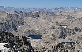
604:
565:
534:
523:Peakbagger.com
506:
505:
503:
500:
499:
498:
492:
491:
475:
472:
452:weather fronts
448:alpine climate
439:
436:
435:
434:
428:
425:
422:
419:
407:
404:
384:Mount Corcoran
351:
350:
345:
337:
336:
333:
327:
326:
322:
321:
316:
310:
309:
304:
298:
297:
292:
286:
285:
281:
280:
272:
266:
265:
260:
252:
251:
238:
234:
233:
222:
216:
215:
208:
207:
201:
200:
199:
198:
189:
183:
182:
175:
174:
168:
167:
166:
165:
164:
163:
160:
159:
155:
154:
149:
143:
142:
138:
137:
105:
99:
98:
93:
87:
86:
83:
77:
76:
70:
64:
63:
60:
54:
53:
50:
44:
43:
39:
38:
32:
24:
23:
15:
13:
10:
9:
6:
4:
3:
2:
727:
716:
713:
711:
708:
706:
703:
701:
698:
696:
693:
692:
690:
681:
680:Mount Newcomb
677:
676:
672:
663:
659:
655:
651:
644:
641:
637:
636:9781594857386
633:
629:
626:R. J. Secor,
623:
620:
617:
615:
608:
605:
594:
590:
586:
585:
580:
574:
572:
570:
566:
555:
551:
545:
543:
541:
539:
535:
524:
520:
514:
512:
508:
501:
497:
494:
493:
489:
478:
473:
471:
469:
465:
461:
457:
456:Pacific Ocean
453:
449:
445:
437:
432:
429:
426:
423:
420:
417:
413:
412:
411:
405:
403:
401:
397:
396:Simon Newcomb
393:
389:
385:
381:
377:
376:Mount Whitney
373:
369:
365:
364:Tulare County
361:
360:Sierra Nevada
357:
356:Mount Newcomb
349:
346:
344:
342:Easiest route
338:
334:
332:
328:
323:
320:
317:
315:
311:
308:
305:
303:
302:Mountain type
299:
296:
293:
291:
287:
282:
279:
278:Mount Whitney
276:
273:
271:
267:
264:
263:Sierra Nevada
261:
259:
253:
250:
246:
245:Tulare County
242:
239:
235:
217:Mount Newcomb
205:
184:Mount Newcomb
172:
161:
156:
153:
152:Simon Newcomb
150:
148:
144:
139:
134:
106:
104:
100:
97:
94:
92:
88:
84:
82:
78:
74:
71:
69:
65:
61:
59:
55:
51:
49:
45:
40:
36:
35:Mount Langley
30:
25:
22:Mount Newcomb
20:
653:
649:
643:
627:
622:
613:
607:
596:. Retrieved
582:
557:. Retrieved
553:
526:. Retrieved
522:
441:
430:
416:class 2
409:
400:first ascent
355:
354:
348:class 2
331:First ascent
314:Type of rock
277:
257:Parent range
638:, pages 62.
307:Fault block
290:Age of rock
128: /
116:118°17′36″W
103:Coordinates
75:(13,474 ft)
68:Parent peak
689:Categories
598:2021-05-18
559:2021-05-18
528:2021-05-18
502:References
468:Kern River
368:California
295:Cretaceous
113:36°32′24″N
58:Prominence
662:1027-5606
158:Geography
147:Etymology
81:Isolation
48:Elevation
616:, (1954)
474:See also
431:The Keep
406:Climbing
325:Climbing
319:granitic
270:Topo map
237:Location
450:. Most
438:Climate
284:Geology
91:Listing
660:
634:
464:runoff
141:Naming
658:ISSN
632:ISBN
335:1936
275:USGS
691::
656:.
654:11
652:.
591:,
587:.
581:.
568:^
552:.
537:^
521:.
510:^
366:,
664:.
601:.
562:.
531:.
Text is available under the Creative Commons Attribution-ShareAlike License. Additional terms may apply.